The Name on the Map Is an Argument: Four Early Maps
The Catalan Atlas is catalogued as 'Abraham Cresques ?'. The Carta Marina survives once, the Tabula Rogeriana only in later copies, the Paris itinerary in four versions. What each label leaves out.
Records in this piece: The Catalan Atlas, Carta marina navigatoria Portvgallen navigationes, atqve tocius cogniti orbis terre marisqve formam natvram sitvs et terminos nostris temporibvs recognitos et ab antiqvorum traditione differentes, eciam qvor vetvsti non meminervnt avtores, hec generaliter indicat, Nuzhat al-Mushtaq fi'khtiraq al-'Afaq (The Tabula Rogeriana), Itinerary from London to the Holy Land
On this page 7 sections
ContentsClose
In short
- The Bibliotheque nationale de France titles the Catalan Atlas 'Abraham Cresques ?' with the question mark in its own catalogue, because the maker is argued from archive documents and not read from a signature.
- The 1516 Carta Marina survives in one copy, and the physical evidence of a proof sheet and a concealed errata patch shows other impressions once existed.
- Al-Idrisi's book of 1154 survives only in copies, the earliest about 1325, and the world map most people picture is Konrad Miller's composite of 1928-1929.
- Matthew Paris drew the London to Jerusalem itinerary at least four times, and one scholar argues that the British Library copy is a later scribe's work made for a king.
Four maps, four labels that say more than the object does
Each of the four early maps in this archive reaches us with a label that is firmer than the object under it. The Catalan Atlas carries a maker's name with a question mark, the Carta Marina of 1516 exists once, the Tabula Rogeriana exists only in copies made long afterwards, and the Matthew Paris itinerary is one of at least four versions with a disputed hand.
A record built from the label alone would give each of them a clean maker, a clean date and an unbroken chain to the library that holds it. The records here do the opposite and keep the argument, because on all four the argument is the part a reader cannot find elsewhere, and it names who disagrees.
The Catalan Atlas is catalogued with a question mark
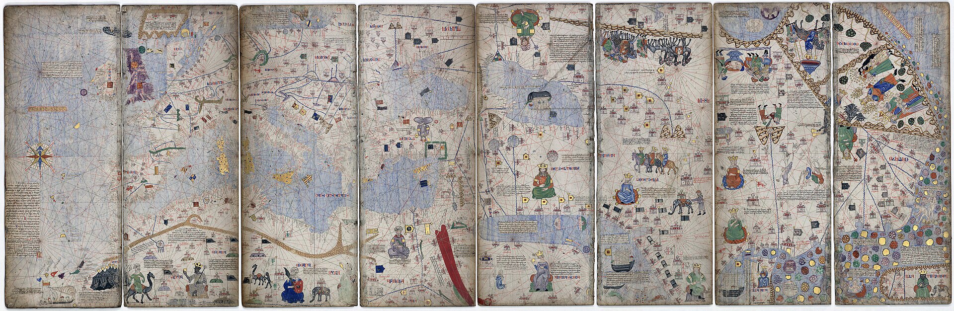
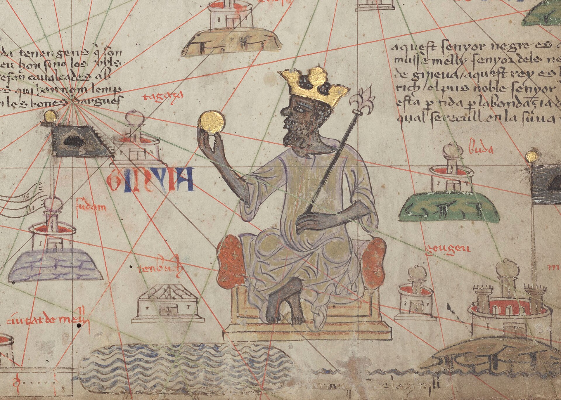
The Bibliotheque nationale de France titles the Catalan Atlas 'Abraham Cresques ?' because nothing on the object names its maker. The attribution rests on archive documents about Cresques Abraham, a Jew of Majorca described as a compass-maker and master of mappaemundi, and not on any signature. The BnF's own reasoning is that the Atlas was made if not by him then in his close circle, and no mappamundi or sea chart signed by him has survived.
The route from Majorca to Paris is open as well. The Atlas was in the Louvre library of Charles V by 6 November 1380, article 200 of Jean Blanchet's inventory, but no document records how it arrived. The gift of 1381 from Joan of Aragon, often cited as its delivery, is read by the BnF as concerning another map, because this one was already in the king's library, while the historian Clara Estow reads the same letters as this atlas's delivery. Two readings of one set of letters is a dispute, and the record keeps it as one.
The 1516 Carta Marina survives in a single copy that may be a proof
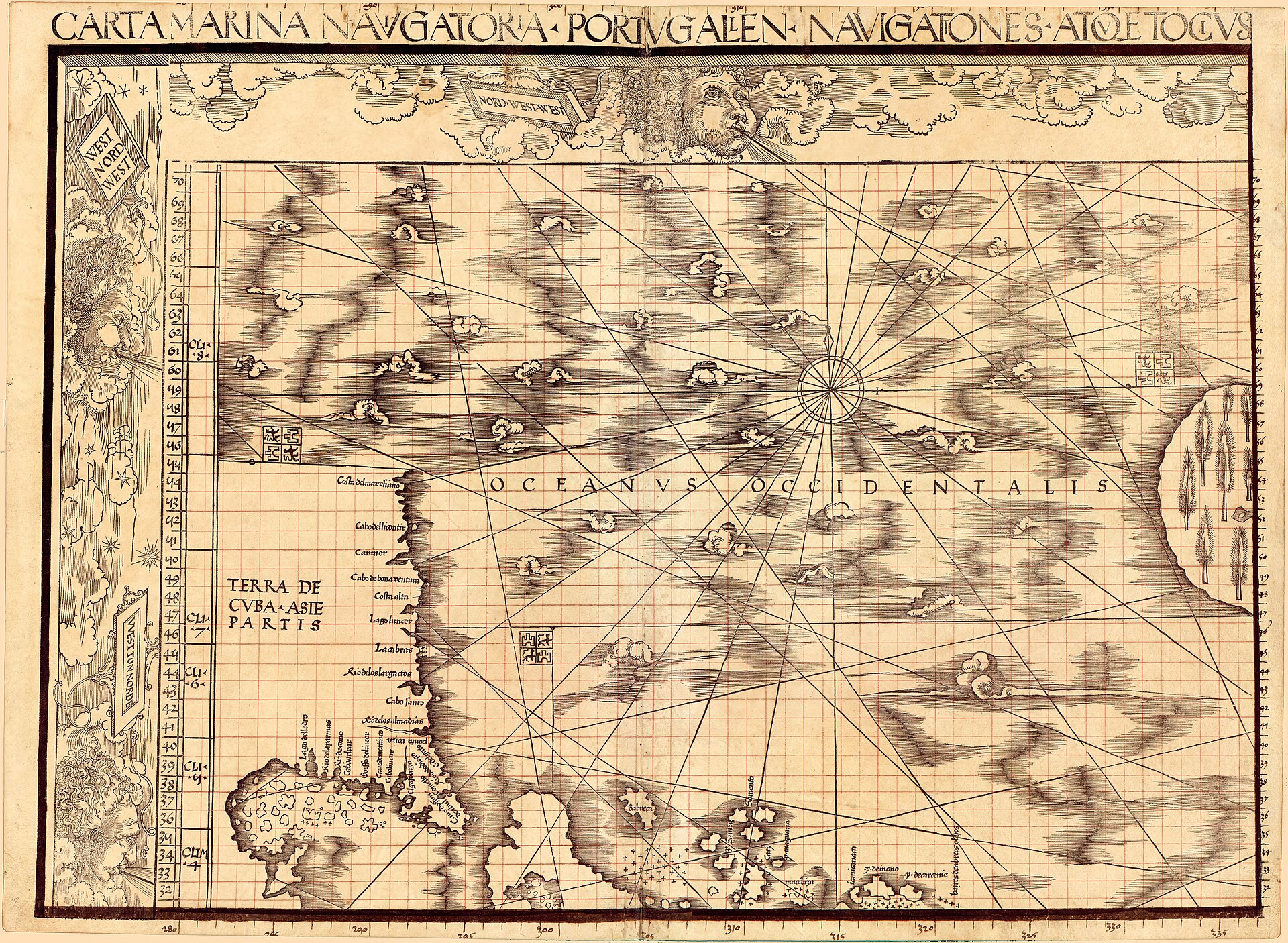
Martin Waldseemuller's 1516 Carta Marina survives in exactly one copy, held in the Jay I. Kislak Collection at the Library of Congress. The printer is not named on the map, and the Library catalogues the place of printing as Strasbourg with a question mark.
Chet Van Duzer's study of the map records physical evidence that more than one impression once existed: a proof sheet, and a small paper patch on sheet 9 that was found in conservation to conceal a printed list of corrections. Hildegard Binder Johnson argued that the map was never put on sale and that the survivor is a proof that never reached a buyer, and Van Duzer notes that no scholar has presented evidence against her. The Library's own exhibition page adds that the artistic detail possibly reflects the hand of Albrecht Duerer, another attribution held at 'possibly'.
The custody of the object is split in the same careful way. It was bound with the 1507 world map in the Schoner portfolio in 1517, but the Library bought the 1507 map in 2003 and its own records place the arrival of the Carta Marina in 2014 and 2015, a transfer its catalogue calls both an exchange and a gift.
Al-Idrisi's book of 1154 survives only in later copies
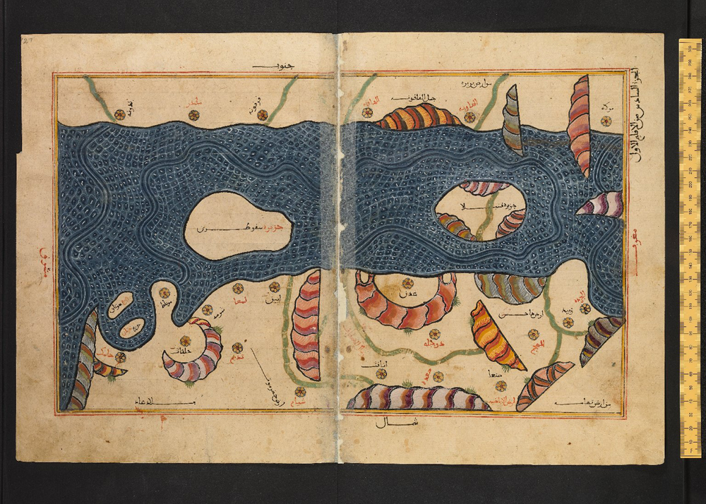
Al-Idrisi's Nuzhat al-Mushtaq was completed in 1154 for Roger II of Sicily, and no manuscript earlier than about 1325 is known. About ten copies survive, and the earliest, Bibliotheque nationale de France MS Arabe 2221, was written some 170 years after the text it carries.
The copy this archive illustrates is Bodleian Library MS. Greaves 42, a copy of the 14th or 15th century by an unnamed scribe at an unrecorded place. Nothing is recorded of where it was before it entered the Bodleian in 1678 with the collection of the Greaves brothers, so the first documented fact about this physical book comes more than five centuries after the text was written.
The image most people picture as the Idrisi map is not a medieval object at all. It is Konrad Miller's composite of 1928 and 1929, assembled from the sectional maps in later copies. The silver planisphere reported to have been made with the book is known only from modern secondary sources, and the record has found no primary source for how or when it was lost.
Matthew Paris drew the same journey at least four times
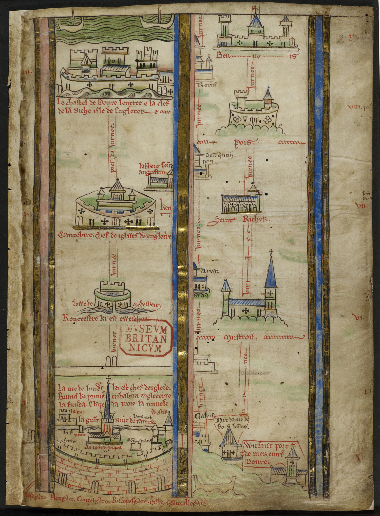
The itinerary from London to the Holy Land in British Library Royal MS 14 C VII, folios 2r to 5r, is one of at least four versions that Matthew Paris is known to have drawn of the same journey. The Library's catalogue describes it as an itinerary from London to the Holy Land with images of towns, their names and descriptions of places.
The standard attribution, following Richard Vaughan's study of Paris's handwriting, treats the prefatory quire as the work of Paris and his St Albans scriptorium. Daniel Connolly, in his 2009 book on the maps, argues that the script, the spelling and the added gold of this copy set it apart from Paris's plainer versions. He proposes a later, unidentified scribe working for a royal patron, probably Edward I. If Connolly is right the intended reader changes from a cloistered monk making an imagined pilgrimage to a king interested in the roads, and the meaning of the map changes with the reader.
No owner is documented between St Albans and the Old Royal Library, and the date the volume entered that library is not recorded. George II gave the Old Royal Library to the British Museum in 1757, and the British Library has held the volume since 1973.
Side by side, the label and the survivor
The table sets out, for each of the four maps, the date it carries, what actually survives and the earliest documented custody.
| Map | Date given | What survives | Earliest documented custody |
|---|---|---|---|
| Catalan Atlas | c. 1375 | Six double parchment leaves, BnF Espagnol 30 | Louvre library of Charles V, by 6 November 1380 |
| Carta Marina | 1516 | One copy, possibly a proof | Johann Schoner, by 1517 |
| Tabula Rogeriana | 1154 (text) | About ten later copies, the earliest c. 1325 | Bodleian Library, 1678 (Greaves 42) |
| Paris itinerary | c. 1250-1259 | One of at least four versions | British Museum, 1757 |
What a record does with the argument
Each of the four records grades the links it cannot document as disputed or unknown and names the scholar or the library that holds the other view. That is the working difference between a label and a record: the label states a conclusion, and the record states who reached it and what the object itself does and does not say.
A reader doing diligence on any of these maps can then see where the firm ground stops. For the Catalan Atlas it stops at the signature, for the Carta Marina at the single impression, for the Tabula Rogeriana at the missing original and for the Paris itinerary at the hand.
Questions
The Bibliotheque nationale de France attributes it to Cresques Abraham, with his son Jafuda, and titles it 'Abraham Cresques ?'. The attribution rests on archive documents about him, not on a signature, and no signed map by him survives.
One copy is known, in the Jay I. Kislak Collection at the Library of Congress. A proof sheet and a concealed errata patch suggest other impressions once existed, but none survives.
No. Al-Idrisi's book was completed in 1154, and about ten manuscript copies survive, the earliest dated to about 1325. The world map usually reproduced is Konrad Miller's 1928-1929 reconstruction.
The standard attribution says Paris and his scriptorium did. Daniel Connolly argues instead that a later unidentified scribe made this gilded copy for a royal patron, probably Edward I.
Sources
- 1Bibliotheque nationale de France, Archives et manuscrits, catalogue entry for Espagnol 30, 'Abraham Cresques ? Atlas de cartes marines, dit Atlas catalan'. archivesetmanuscrits.bnf.fr/ark:/...
- 2Leopold Delisle, Recherches sur la librairie de Charles V, vol. 1 (Paris: H. Champion, 1907), for the inventories of the Louvre library. archive.org/details/...
- 3Library of Congress exhibition, '1516 Carta Marina Map', Waldseemuller Maps, Exploring the Early Americas. loc.gov/exhibits/...
- 4Chet Van Duzer, Martin Waldseemuller's 'Carta marina' of 1516: Study and Transcription of the Long Legends (Springer, 2020). doi.org/10.1007/...
- 5Bodleian Libraries, 'Medieval Islamic maps of the world', The Conveyor, on Bodleian MS. Greaves 42. blogs.bodleian.ox.ac.uk/theconveyor/...
- 6British Library Archives and Manuscripts Catalogue, 'Royal MS 14 C VII, ff 1v-8r', itinerary from London to the Holy Land. searcharchives.bl.uk/catalog/...
- 7Camille Serchuk, review of Daniel K. Connolly, The Maps of Matthew Paris, The Medieval Review. scholarworks.iu.edu/journals/...
More in Attribution and Authenticity
The partWhat the Name al-Mawsili Tells You About Where It Was Made
Two signed ewers, a pyxis and a candlestick carry or borrow the name al-Mawsili. What the name proves about Mosul, and where the museums place each...
Paintings Draw the Attribution Fights, but Glass Is Disputed Far More Often
Seven of 45 paintings carry a disputed attribution and seven of 16 glasses do. No print does. A table of 330 records by object type.
The Name on an Instrument Covers More Than One Maker
A harpsichord with a false Ruckers rose, a Couchet rebuilt to pass, the oldest piano with a 1938 soundboard and a harp with a legend.