The Catalan Atlas
Abraham Cresques · c. 1375 (calendar computed from 1375, with 1376 and 1377 announced; in the Louvre library by 6 November 1380; Gallica gives 1370-1380)
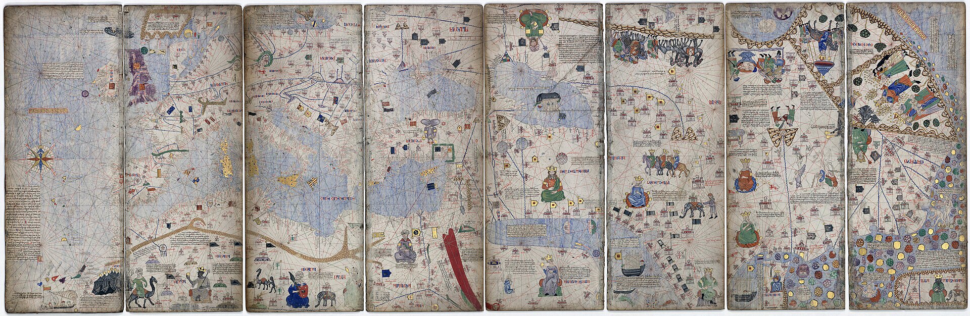
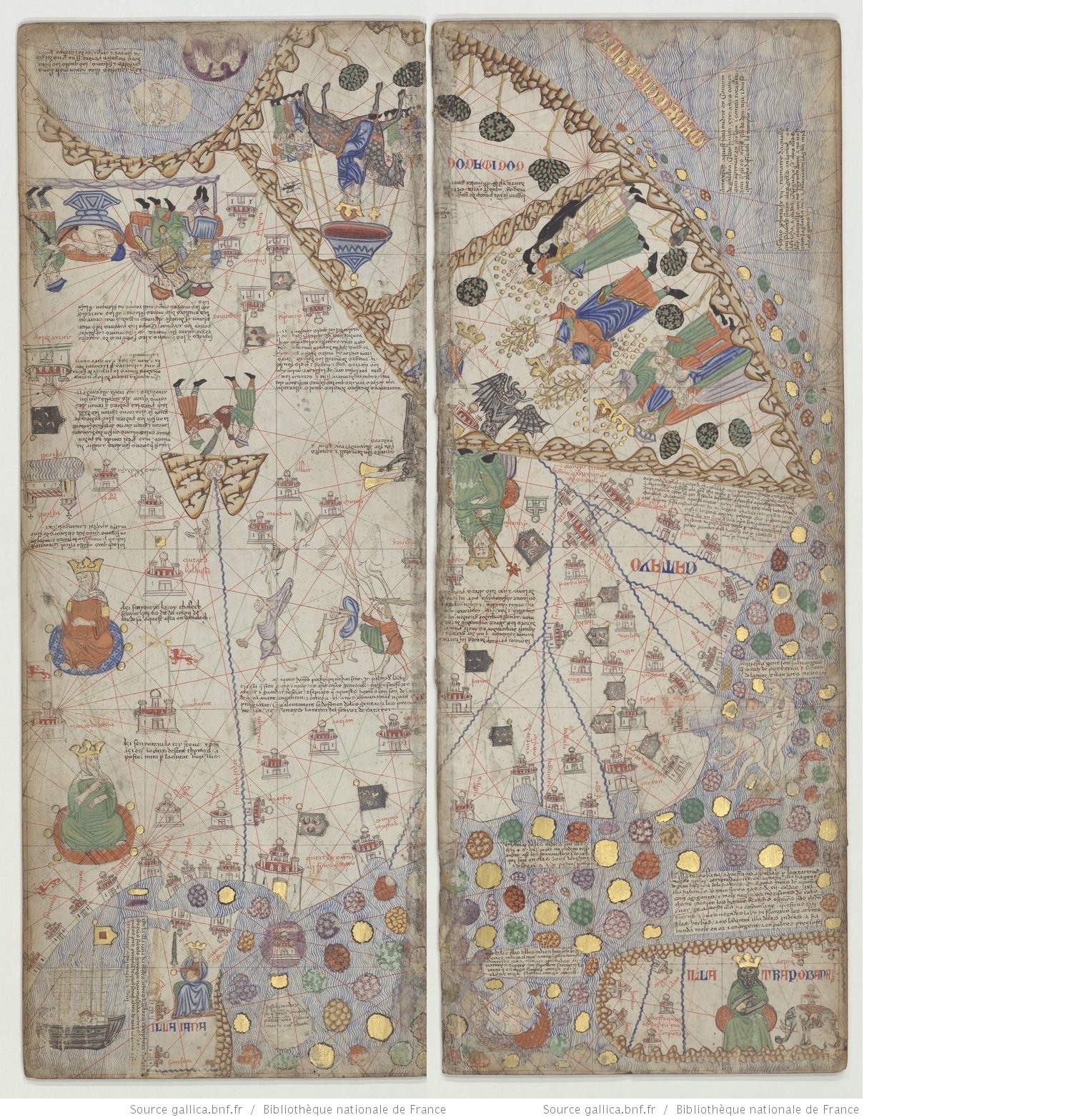
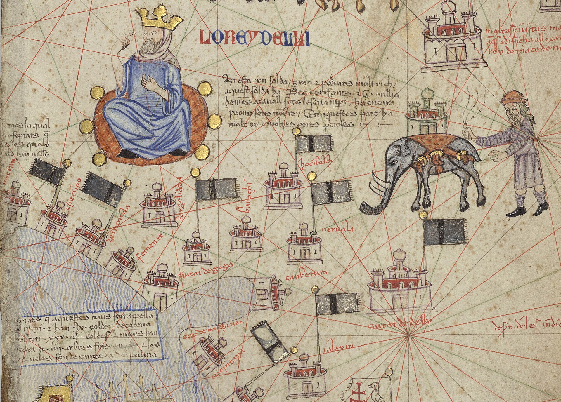
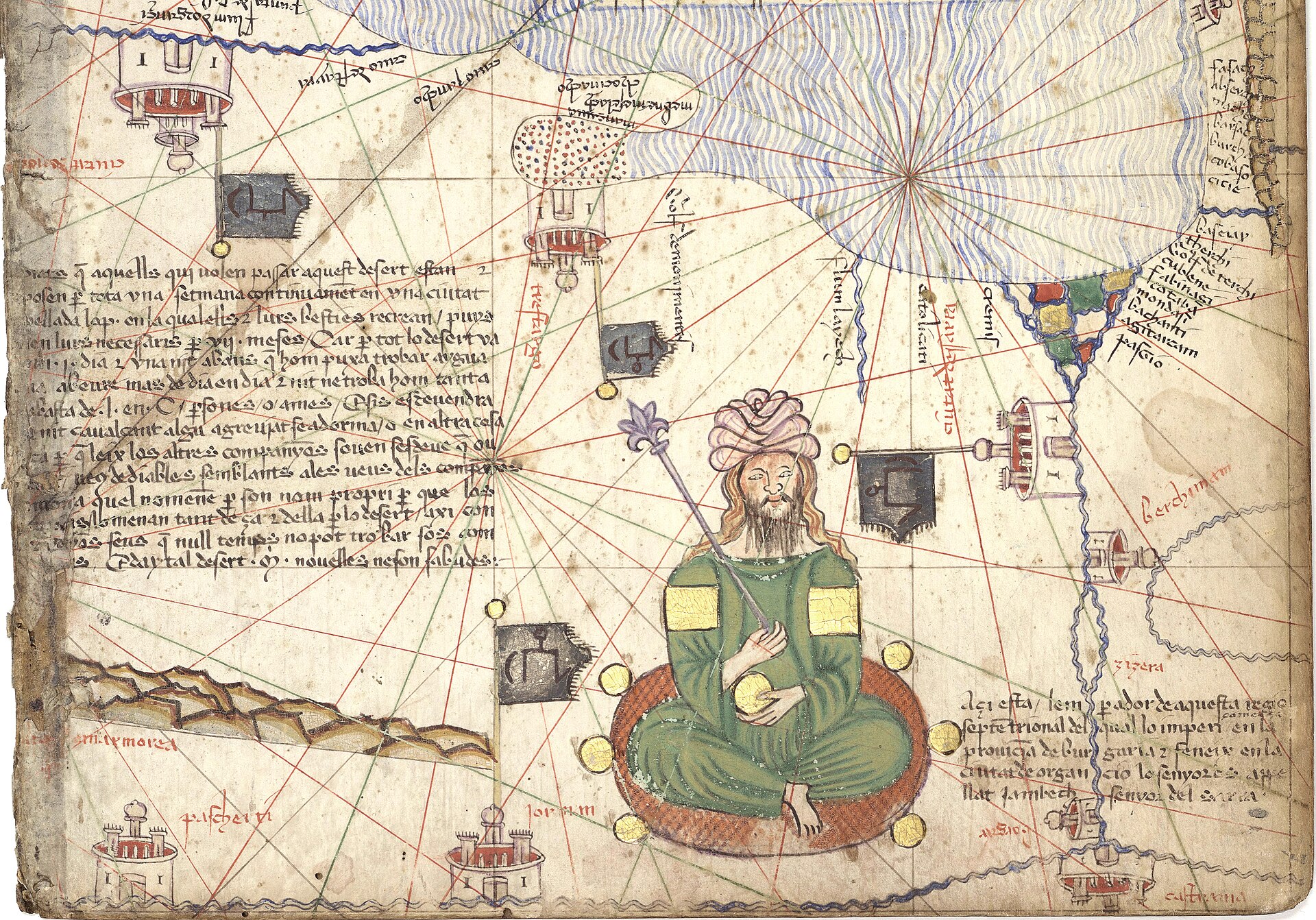
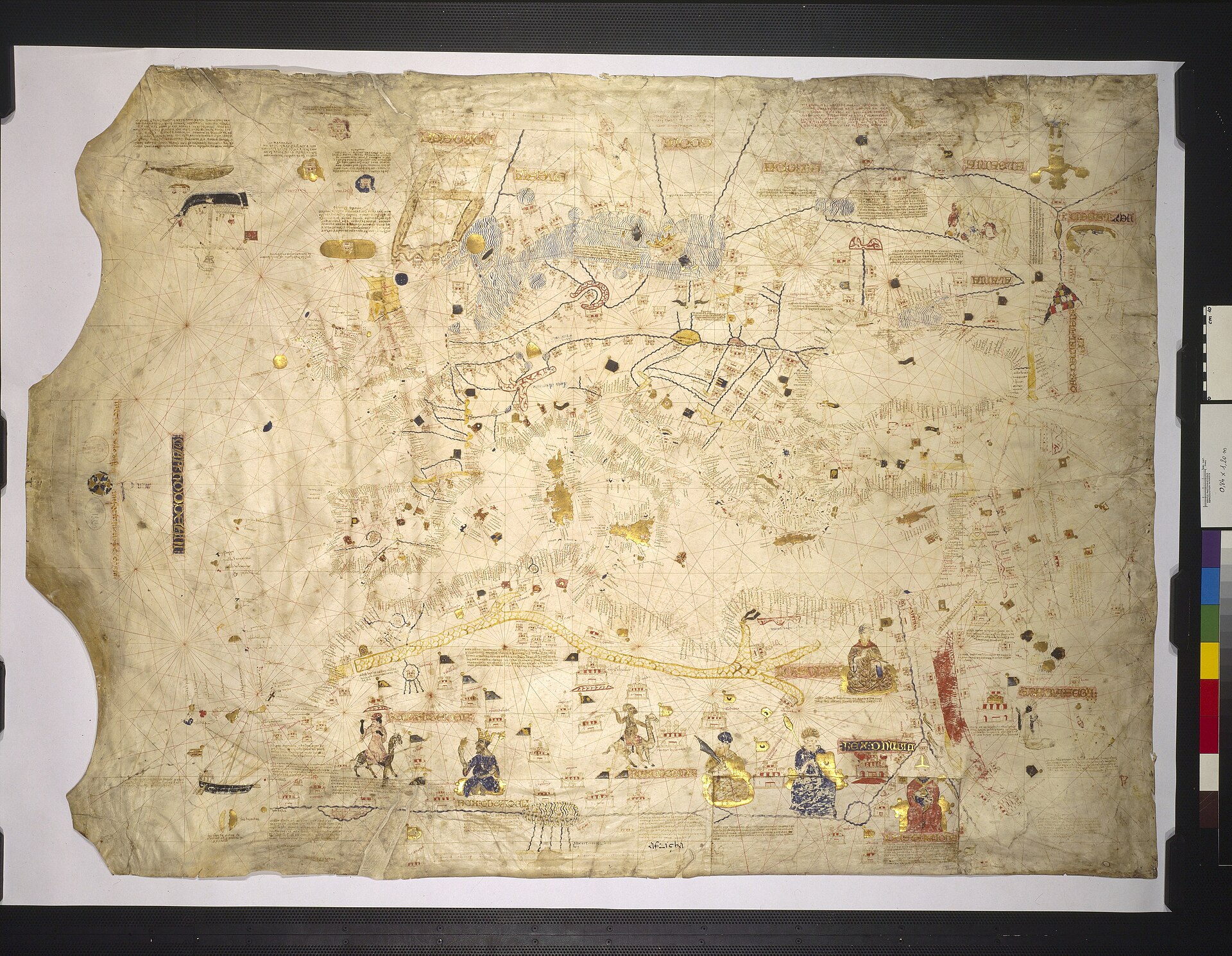
Montage of the eight half-leaves of the four map leaves (leaves 3 to 6) of the Catalan Atlas, BnF Espagnol 30, from Gallica, shown with south at the top and the Far East at the right as the BnF's own display arranges them. The first two leaves, with the calendar and cosmography, are not in this view. This IS the object described in this record.
| Artist | Abraham Cresques |
|---|---|
| Date | c. 1375 (calendar computed from 1375, with 1376 and 1377 announced; in the Louvre library by 6 November 1380; Gallica gives 1370-1380) |
| Medium | Pen and brush with opaque colours, burnished gold and burnished silver on parchment, pasted on wooden boards, in a Parisian calf binding of c. 1515 |
| Dimensions | Six double leaves; each folded half 645 x 250 mm (BnF), about 65 x 50 cm opened, about 65 x 300 cm across all six leaves |
| Where it is now | Bibliotheque nationale de France, Departement des Manuscrits, Parislast confirmed |
| Inventory number | Espagnol 30 (formerly Supplement francais 1191 by mistake; Regius 6816; Espagnol 119 in 1892) |
| Attribution | DisputedAttributed to Cresques Abraham of Palma, master of mappaemundi and compass-maker, with his son Jafuda (Jehuda). Full note |
| Object type | Map |
| Period | Majorcan, Crown of Aragon, fourteenth century |
| Cases | Disputed attribution · Has a provenance gap |
| Inscriptions | Legends in Catalan in a minuscule hand; names of countries in alternating red and blue capitals; the date 1375 in the calendar; wind names in the Atlantic rose; map drawn with south at the top |
| Owners on record | 9 links4 documented, 2 disputed, 3 unknown |
| Sources | 23 cited |
About this record Last verified · 23 sources cited · Change log
On this page 11 sections
ContentsClose
The Catalan Atlas, which the BnF's own web page calls the finest work to come from the Majorcan cartographic school, is six double parchment leaves painted in Majorca about 1375, attributed to the Jewish cartographer Cresques Abraham with his son Jafuda, and kept in the Bibliotheque nationale de France as Espagnol 30. Two leaves hold a cosmography, a tide table and a calendar with rules for bloodletting; four hold a sailing chart stretched from the Atlantic to China, with Musse Melly of Mali holding gold, Marco Polo's Asia and the end of the world at the eastern edge.
It was in the Louvre library of Charles V by 6 November 1380, article 200 of Jean Blanchet's inventory, and stayed in the royal collections, valued at four livres in 1424. The gift of 1381 from Joan of Aragon that is often cited as its delivery concerns another map, on the BnF's reading, and no document records how this one reached Paris.
This record separates what the inventories and archives document from what is argued: the attribution to Abraham, the share of his son, the commission and the sacred-history layout. There is no sale or auction to report, but a recorded gap of some 250 years in the provenance, a full open digitisation on Gallica and a handful of unsolved identifications.
Provenance
Each link is graded. Documented: a cited source supports it. Disputed: the identification is argued but not established. Unknown: no owner for that span, and the gap is not smoothed into a narrative. The grades in the glossary.
- c. 1375 - before 6 November 1380Made at Palma de Majorca, attributed to Cresques Abraham with his son Jafudadisputed
Majorca is given as the place of copy by the BnF and Gallica. The calendar is computed from 1375. Authorship is an argument from archive documents about Cresques Abraham, not from a signature; the BnF titles the work 'Abraham Cresques ?'. The commission, patron and recipient are not documented for this object.12710
- c. 1375-77 - before 6 November 1380Unknown route from Palma to Parisunknown
Secondary writing names Joan of Aragon as donor and 1381 as the year of delivery. The BnF rejects the 1381 letters as evidence for this object, because the Atlas was already in Charles V's library. Estow, by contrast, reads the 1381 letters as its delivery. No document of the transfer has been found.16818
- by 6 November 1380 - 1380Charles V, King of France (died 16 September 1380), Louvre library, in the keeping of Gilles Maletdocumented
Article 200 of Jean Blanchet's recolement of 6 November 1380 (BnF Francais 2700, f. 11v), with the note 'Il y est'. The inventory does not date individual additions; arrival during the king's lifetime is the BnF's and Delisle's reading, and Delisle shows it was added after the 1373 inventory. Tastu places it in the lower chamber about 1378 without naming a document.16722
- 1380 - 1424Charles VI, King of France, Louvre library (keepers Gilles Malet, Antoine des Essars, Garnier de Saint-Yon)documented
Described in the inventories of 1411 (Francais 2700 f. 63), 1413 (Francais 9430 f. 10) and 1424 (Mazarine 2030 f. 16). The 1424 entry gives a value of 4 livres parisis. Tastu dates the later inventories 1415, 1423 and 1425.167
- 1424 - 1425English regent John, Duke of Bedford, buyer of the Louvre libraryunknown
Bedford took possession of the library on 22 June 1425 and paid, per Delisle, 1,200 livres. No document found places the Atlas in Bedford's lot or among the books he sent away, and the BnF states only that it stood in the Louvre library until the library's dispersal.16
- 1425 - c. 1515Unknownunknown
Not in the library of Jean de Berry (the 5-livre mappamonde of 1413 and 1416 was already his). The BnF finds no support for E. Pognon's claim that it stood in the Blois library and reads the Blois items of 1518 and 1544 as Louis XII's seven-leaf atlas, Latin 4850.1
- c. 1515 - 1622Unknown, in Paris; rebound in the workshop attributed to Simon Vostre (Louis XII)disputed
The white leather cover of Charles V's time was replaced by the present Parisian calf binding, which the BnF attributes to the Vostre workshop and dates to about 1515. The attribution is by tooling; the owner at the time is not named. The Atlas is not in Rigault's inventory of 1622.1
- 1682 - 1797Bibliotheque du Roi, Parisdocumented
Number 6816 in Nicolas Clement's Regius catalogue of 1682, 'Anciennes cartes cosmographiques avec l'explication en catalan'. The number is not written on the volume.17
- 1797 - presentBibliotheque nationale (de France), Departement des Manuscrits, Espagnol 30documented
Repaired with the cipher BN and RF in 1797 or 1803 by the binder Durand or his son; marked by mistake as Supplement francais 1191 under the July Monarchy; Espagnol 119 in Morel-Fatio's inventory of 1892; now Espagnol 30. Binding restored in 1991; digitised in high definition in 2017. Modern geographers knew it from about 1803 (Tastu); first edition by Buchon and Tastu, 1839-1842.1267
Technical evidence
| Attribution note | Attributed to Cresques Abraham of Palma, master of mappaemundi and compass-maker, with his son Jafuda (Jehuda). The BnF titles it 'Abraham Cresques ?'. The attribution rests on archive documents about Cresques's mappaemundi and on stylistic kinship with the Hebrew Farhi Bible, not on a signature; the BnF concludes it was made if not by him then in his close circle. Campbell calls it the only work confidently, though not conclusively, assigned to Cresques Abraham. Whether Abraham or Jafuda drew which leaves is undocumented. |
|---|---|
| Support | Parchment (vellum): six double leaves, pasted recto and verso to five wooden boards and to the wooden inner covers.14 |
| Dimensions | Each folded half-leaf 645 x 250 mm (BnF); each double leaf about 65 x 50 cm opened; about 65 x 300 cm across all six leaves. Tastu in 1839 gave 23 by 18 pouces per leaf, folding into two halves of 9 pouces.147 |
| Medium and decoration | Pen drawing with opaque colours (blue, green, orange, mauve, gold yellow, ochre, pink, red), several motifs in burnished gold with colour highlights and burnished silver; filigree palmette grounds behind the circular diagrams; burnished gold initials with limited filigree in the text; red and violet inks. Twelve full-page paintings.1 |
| Language and hand | Catalan legends in a minuscule hand, country and region names in alternating red and blue capitals, coastal names perpendicular to the shore in black or red.17 |
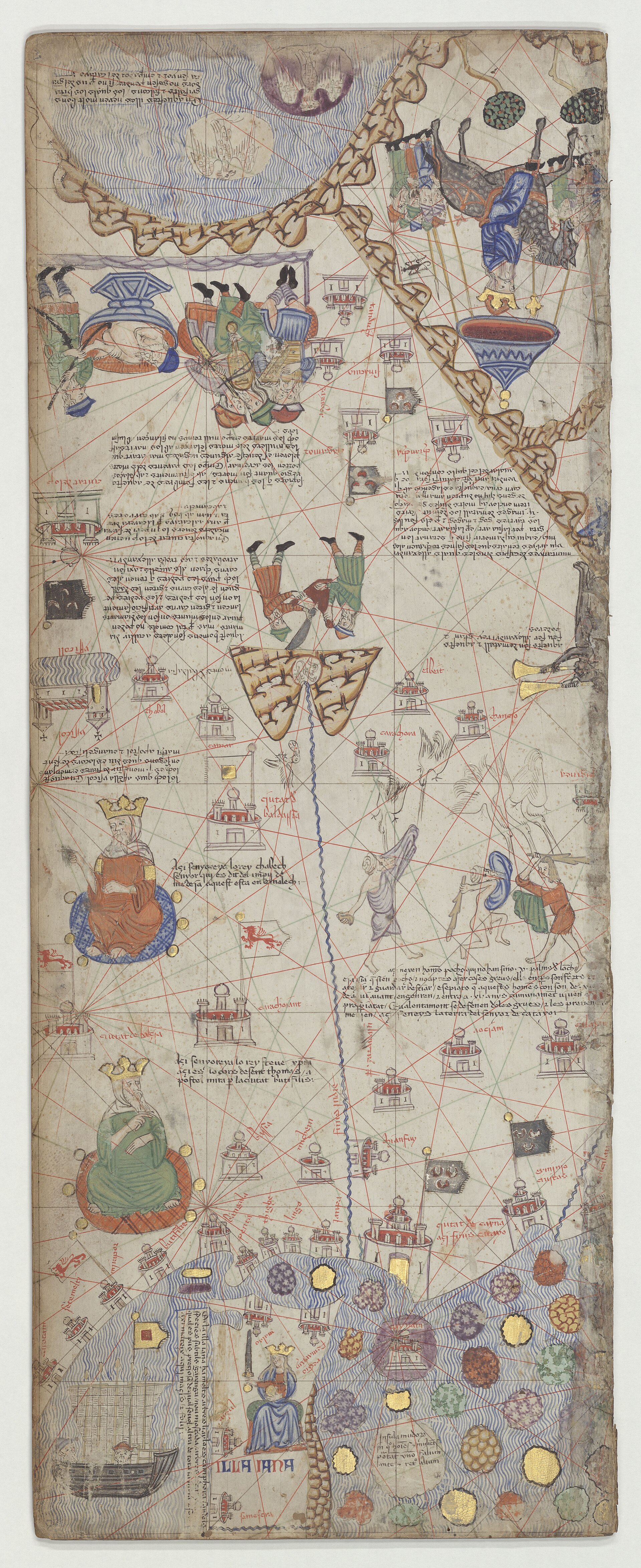
| Arrangement | Leaves 1-2: cosmography, tide diagram, movable-feast wheel, zodiac man, lunar table and circular calendar. Leaves 3-6: Far East and India, India to the Caspian, Persian Gulf, Arabia and Mecca; the Near East and eastern Mediterranean; the western Mediterranean and the Atlantic coast, with Scandinavia, the British Isles and the Canaries.1 |
| Orientation and reading order | South at the top on every map leaf; read from the Far East at the left to the Atlantic at the right. The order of the mounted leaves dates from shortly after 1500 according to Grosjean.149 |
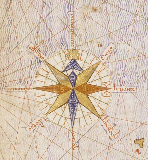
| Rhumb lines and scale | One wind system per page with 16 secondary centres, diameter 47 x 49 cm; main winds black, half-winds green, quarter-winds red. Scale bar on the westernmost leaf: 10 mm per division, five divisions 51 mm. An eight-point wind rose in the Atlantic, its winds named tramontana, grego, levante, laxaloch, merzodi, labetzo, ponente, magistro.1 |
| Names | About 2,300 place names, 1,120 of them coastal (Galera i Monegal 2016, via Liscak).9 |
| Date evidence | Golden-number calendar computed from 1375, with 1376 and 1377 announced (Tastu); entered in the Louvre library on or before the 6 November 1380 inventory. Gallica gives 1370-1380.127 |
| Binding | Parisian brown calf over light wooden boards, spine lost, cold-stamped and gilt tools, attributed to the Simon Vostre (Louis XII) workshop, c. 1515; board edges gilt and chiselled with lozenges and scrolls. Replaced Charles V's white-leather cover with four copper clasps and two open roundels.16 |
| Condition | Leaves split along the middle fold because the parchment no longer holds the boards together; water stains on the board edges; leather repaired with the BN and RF cipher in 1797 or 1803 and again in 1991.17 |
| Scientific analysis | Physico-chemical analysis of the paintings by the BnF scientific laboratory in 2018 (dossier BnF RIL 2018-014); results not located in published form.1 |
| Shelfmarks carried | Espagnol 30 (BnF, Departement des Manuscrits); formerly Supplement francais 1191 (a mistaken marking); Regius 6816 (Clement, 1682); Espagnol 119 (Morel-Fatio, 1892); Louvre inventories: article 200 or 201 in 1380, Francais 2700 f. 63 art. 132 in 1411, Francais 9430 f. 10 art. 129 in 1413, Mazarine 2030 f. 16 in 1424.1367 |
| Digital surrogate | Gallica ark btv1b55002481n; high-definition scan of 2017; 18 canvases of about 6,400 x 15,800 px in the IIIF manifest; rights stated as public domain. A BnF commentary site and the BnF Enluminures page also exist; Commons holds Gallica-derived images of every leaf.234523 |
| Legends | The Cresques Project publishes English translations of the map legends of the four map leaves (Panels III to VI), based on the 1975 Diafora facsimile transcription and the BnF scans; Buchon and Tastu (1839) transcribed and translated every legend into French.711121314 |
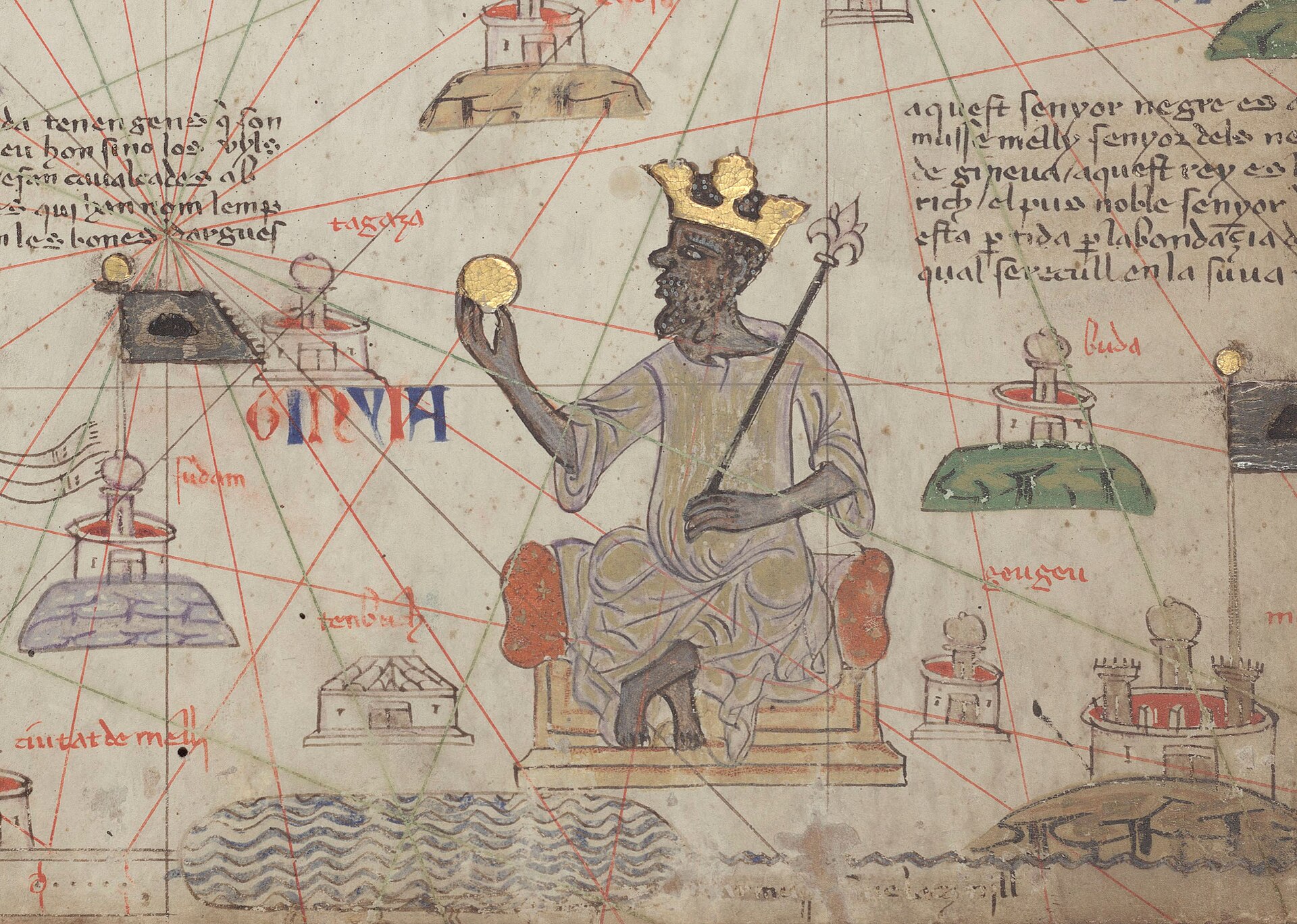
| Mali king | The legend names the crowned figure Musse Melly; the BnF reads him as Mansa Musa of Mali (reign c. 1312 to c. 1337, pilgrimage 1324-25). The figure holds a gold piece and a fleur-de-lis sceptre.41121 |
| King of Organa | A Saracen king in the central Sahara, with a palm-tree flag; no medieval African state of that name is known. Published readings: Kanem, Ouargla, Ife, Ghana (as summarised by Wikipedia from Obayemi, Blier, Masonen and Falchetta).1217 |
Images
The record in full
Chapter 1Six double leaves of parchment, pasted to boards and painted to be read as one book
The Catalan Atlas is six double leaves of parchment, each about 65 by 50 cm when opened, painted in pen and brush with opaque colours and burnished gold and silver.
The Catalan Atlas is six double leaves of parchment, each about 65 by 50 cm when opened, painted in pen and brush with opaque colours and burnished gold and silver. The BnF catalogue counts twelve full-page paintings and gives 645 by 250 mm for each folded half; laid end to end the six leaves run to about 65 by 300 cm. The first two leaves carry texts and diagrams: cosmography, a calendar, astronomy and astrology. The other four are drawn on the plan of a sailing chart and carry the map, with Jerusalem close to the centre of the whole.
It is not a codex in the ordinary sense. Each half-leaf is pasted to one face of five wooden boards, and the first half of the first leaf and the second half of the last leaf are pasted inside the covers. The parchment itself once held the boards together; it has since broken, so every leaf is badly worn along the middle, and the catalogue notes water stains on the board edges. The 1411 inventory describes the object as six large leaves of wood with the parchment glued on, closing with four copper clasps and covered in white leather with two open roundels. That white cover is gone. The present binding is Parisian brown calf over thin wooden boards, cold-stamped and gilt, attributed by the BnF to the workshop of Simon Vostre (also called the workshop of Louis XII) and dated about 1515, with gilt and chiselled board edges. The spine has vanished entirely.
The orientation is unusual. The BnF reads the leaves with south at the top and the sequence running from the Far East at the left to the Atlantic at the right, so that the book opens on the calendar and the cosmography, passes to the end of the world in the east and travels west. Georges Grosjean, whose 1977 facsimile commentary Liscak summarises, held that a portolan-style map has no priority orientation and that, because the work was a luxury piece for a princely library and not a working chart for a ship, asking for its correct orientation is pointless; he also dated the present order of the mounted leaves (I-II-VI-V-IV-III, south up) to shortly after 1500, while facsimiles usually print the leaves north up in the order I to VI.
The construction is that of a sailing chart. The catalogue records one system of rhumb lines per page, with sixteen secondary centres centred on the fold and a diameter of 47 by 49 cm: principal winds in black, half-winds in green, quarter-winds in red, with the figures painted over the lines (the green ones show through on the Red Sea). A graduated scale runs across the top of the westernmost leaf, each division 10 mm and five divisions 51 mm. Liscak, citing Galera i Monegal (2016), counts about 2,300 place names in all, 1,120 of them on coasts, 620 on the northern shore of the Mediterranean alone. Cities are small walled towers; European ones carry steeples and pointed roofs, Muslim and eastern ones domed or bulbous towers, and the BnF's older English page adds that Christian cities are marked with a cross, the others with a dome, and that port names are in red.
Chapter 2A Majorcan workshop, a Jewish family and a name the documents attach to other maps
Nothing on the object names its maker. The BnF still titles it 'Abraham Cresques ?', with the question mark, because the attribution rests on archive documents about a Jew of Majorca called Cresques...
Nothing on the object names its maker. The BnF still titles it 'Abraham Cresques ?', with the question mark, because the attribution rests on archive documents about a Jew of Majorca called Cresques Abraham, described as a compass-maker and master of mappaemundi, and not on any signature. The BnF's own reasoning is cautious: the numerous documents about him suggest that the Atlas was made if not by him then in his close circle, although no mappamundi or sea chart signed by him has survived.
The documents the catalogue cites are these. On 15 April 1368 Peter IV of Aragon admitted him to the royal household in recognition of his services, an honour that also freed him from the roundel Jews were required to wear. He owned a house with a garden near the Temple gate in Palma, and in 1378 obtained the right to draw part of a city fountain's water for his own use. In 1381 the Infante Joan renewed the status of familiaris for him and for his son Jafuda, the Jehuda of the usual spelling. On 20 March 1382 Peter IV ordered 150 Aragonese gold florins paid to Cresques Abraham, 'judeo de domo nostra, magistro de mapamundi', for certain tablets bearing the figure of the world. In 1387 a letter of Joan I ordered 60 livres 8 sous paid to Jafuda Cresques for a mappa mundi begun by Abraham two years earlier, which the BnF reads as showing that the son had taken up his father's work, the father having died probably shortly before.
Jafuda was forced to convert with the rest of his family in 1391 and took the name Jacobus (Jaume) Ribes, according to the BnF. Older reference works go further. The Encyclopaedia Judaica has him settle in Barcelona in 1394, hold the title magister cartarum navegandi from 1399, and be the Mestre Jacome of Majorca whom Henry the Navigator drew to Portugal in the 1420s; that identification goes back to Gonzalo de Reparaz in 1930. Against it, the BnF cites court papers of 1410 naming Dulcia, widow of Jaime Ribes, 'sans doute' the widow of Jafuda, and states, following Riera, that Jafuda was already dead by 1410, and the English Wikipedia article summarises recent research as concluding that Mestre Jacome must have been someone else. The Henry the Navigator link is therefore graded disputed here.
The most interesting strand ties the cartographer to a Hebrew book. The BnF gives the colophon of the Farhi Bible in French translation: Elisha, son of Abraham, son of Benveniste, son of Elisha called Cresques, finished the Bible on Wednesday 13 Kislev 5143, 19 November 1382, for himself, having begun it at the age of 41 in 1366. Jaume Riera argued in 1975 that Elisha and Cresques Abraham are one man, Abraham being not a first name but his father's name and Elisha his liturgical name, which gives a birth year of 1325 (the 'life' dates used on this record) and a death about 1387 at the age of 62. The BnF notes real stylistic kinship between the Bible and the Atlas: borders imitating oriental carpet interlace, chequered backgrounds, vivid colours, and the open tent that stands for Jacob's camp in the Bible and for the nomad camps of the Maghreb in the Atlas, and judges it quite possible that one illuminator decorated both. Katrin Kogman-Appel's 2020 monograph builds a full intellectual profile on that identification and presents Elisha ben Abraham Bevenisti Cresques as a hub where mapmaking met scribal work, miniature painting met scientific knowledge and a minority culture met the majority's.
Tony Campbell's census of unsigned charts sets the limits. In his view the Atlas is the only work confidently, though not conclusively, assigned to Cresques Abraham, and 'a thoroughly atypical presentation piece'. The five charts that Ramon Pujades grouped with it as a 'Cresques workshop' show, on Campbell's colour-and-shape analysis, no proof of one supervised atelier; Campbell suggests a small family operation lasting about two generations, with successive apprentices, whose members never signed, perhaps as a matter of policy for presentation pieces. One apprentice is documented: Samuel Corcos, a Jew who converted as Macia de Viladesters, served 1384-90 under Jafuda Cresques, yet his earliest surviving chart of 1413 matches the Atlas on only 47 per cent of the features Campbell compared.
The attribution is therefore graded in layers. That a Palma workshop of the Cresques family made it is argued by the BnF and by the literature above. That Abraham himself drew it is accepted by tradition and unproven. The share of Jafuda, who is usually named beside his father, is undocumented for this object; the only record of his hand is the 1387 payment for a different mappa mundi.
Chapter 3The calendar says 1375; the Louvre inventory says no later than November 1380
The date comes from the object itself. The BnF dates the Atlas 'around 1375', the year that enters the calculation of the golden number in the perpetual calendar, and says the date appears several...
The date comes from the object itself. The BnF dates the Atlas 'around 1375', the year that enters the calculation of the golden number in the perpetual calendar, and says the date appears several times there. Buchon and Tastu noticed that the author takes 1375 as the current year and announces 1376 and 1377 as the next two. Gallica's metadata gives the range 1370-1380, and recent English-language writing hedges with 'the late 1370s or the early 1380s'.
Tastu pressed the point in a long footnote. If the work had been made in another year the author would have given the golden number for that year; since six leaves of this size could hardly have been written and painted in the course of 1375 alone, he thought they were delivered during 1376 and 1377. He added an argument from absence: no papal banner is drawn over Rome or Avignon, which he explained by the papacy's move from Avignon in 1376 and by Peter IV of Aragon's refusal to choose between the rival popes afterwards. Tastu credits his friend d'Avezac with having been first to say 1375. The papal-banner argument is Tastu's inference and is not repeated in the BnF catalogue.
The other end of the window is documentary and firm. The Louvre library of Charles V was inventoried in 1373 by its keeper Gilles Malet; that original is lost. Two months after the king's death on 16 September 1380, Jean Blanchet, acting for the Duke of Burgundy, checked every book against a copy of the inventory on 6 November 1380, and the Atlas is on it. Delisle observed that the 1380 copies were made from the 1373 original with no marking of additions made in between, and he lists the Atlas among seven items he identified as later additions, the others being dated by inscriptions in the books themselves; for the Atlas he relied on its own date, which he thought 'selon toute apparence' to be 1375. So the Atlas was finished no earlier than 1375 and was in the Louvre library by 6 November 1380, though the inventory does not date individual additions. Tastu adds, without naming a document in his note, that it stood in the Louvre's lower chamber about 1378.
Chapter 4The royal gift of 1381 is the letter everyone cites, and it concerns another map
The usual account runs as follows: the Infante Joan of Aragon, later John I, gave the Atlas to Charles V of France, and it reached Paris in 1381 in the hands of Joan's wife Violante of Bar.
The usual account runs as follows: the Infante Joan of Aragon, later John I, gave the Atlas to Charles V of France, and it reached Paris in 1381 in the hands of Joan's wife Violante of Bar. The French Wikipedia article states it so, citing Estow and a Seuil survey. The documents behind it are two letters written by Joan on 5 November 1381. In the text Hamy published in 1891 (as reproduced on the French Wikipedia, and summarised by the BnF), Joan tells the king of France that he is sending 'une mappemonde' by Guillaume de Courcy, that it is kept in the archives at Barcelona in the keeping of one P. Palau, that it is to be handed over without any receipt, and that the Jew who made it is to be found in the Jewish quarter to instruct Courcy in everything necessary, failing whom two good sailors are to explain it.
The letters do not fit the Atlas on two counts. First, the date: Charles V died on 16 September 1380, so a letter of November 1381 is addressed to his son Charles VI. Estow notes that the printed Documents wrongly address it to Charles V, a typesetter's error she says has caused great confusion. Second, the inventory: the BnF catalogue records that already in 1891 Hamy pointed out that the mappemonde of the letter could not be the Atlas, which was by then in Charles V's library, and the BnF's account of the object's history follows that conclusion. Delisle gives the November 1381 mappemonde a place in his chapter on Charles VI's library and treats the Atlas separately under its own catalogue number, without joining the two.
The dissent is published. Estow's 2004 article treats the 1381 letters as the delivery of the Atlas, writing that it appears a Catalan atlas was delivered to Paris in 1381. Her footnotes list what else Rubio i Lluch's Documents contain: a letter of 1373 from the then Infante Joan to a Majorcan cartographer commissioning a carta de navegar, and a commission of September 1379 for a mappamundi that would set out what a Majorcan recently returned from Tartary and the Indies had reported. Neither text is shown to describe this object. Estow also points out that a statement attributed to Charles V, that he wanted a mappamundi showing the eastern and western parts of the world, rests on a mis-citation in Francesc Relano's book of two of those documents.
A third version, repeated in popular and older reference writing, has Joan commissioning the Atlas from Abraham and Jehuda in 1374-75 for 150 florins and 60 Majorcan pounds. Liscak cites Porcel (2002) for the sums, and Wikipedia's articles on the Cresques family repeat it. The payments the BnF cites are dated 1382 and 1387 and are not tied to the Atlas by any text. What survives is therefore an object, an inventory entry and a set of letters about other maps. There is no contract, receipt or letter that names this object, and how it passed from Palma to Paris between about 1375 and 6 November 1380 is not documented. The BnF offers one clue: the fleur-de-lis and geometric ground of the first leaves suggests to its authors that the book was meant for the king of France from the start. Tastu argued, from the evidence of the work itself, that it was made to serve Charles V of France, and explained the Italian-looking wind names on the rose by saying that the nomenclature adopted by all the navigators of the day was preferred.
Chapter 5In the Louvre tower: Gilles Malet, Jean Blanchet and article 200
Charles V kept his books in a tower of the Louvre, in three chambers one above another.
Charles V kept his books in a tower of the Louvre, in three chambers one above another. Their keeper was Gilles Malet, a valet de chambre in the king's service from 1364 and keeper of the library from 1369 at the latest, whom Christine de Pizan praised as a reader and a man of composure. Malet's 1373 inventory is lost. The two copies made in 1380 survive: a register in which Blanchet noted which books were missing, now Francais 2700 in the BnF, and a parchment roll that passed through Baluze's hands into the royal library in 1719.
On Blanchet's register the Atlas is article 200. The entry reads 'Une Quarte de mer, en tabliaux faite par maniere de unes tables painte et ystoriee, figuree et escripte, et fermant a .IIII. fermoers', and the marginal note in the register says 'Il y est', it is there. Editions differ over the number: Tastu notes that the printed inventory of 1836 wrongly has 201, and Delisle, following Van Praet's numbering, calls it A 201 and B 200. The clerks did not call it an atlas or a mappamundi; a 'quarte de mer' is a sea chart, and the 'tabliaux' are panels. The first series of the inventory, numbers 1 to 269 on the register, lists the books of the lowest chamber, which fits Tastu's remark that the Atlas stood in the chamber below.
The same object is described again in the inventories of 1411, 1413 and 1424, with the detail quoted earlier: six large wooden leaves, the parchment glued on, four copper clasps, white leather with two open roundels. Tastu dates the later inventories 1415, 1423 and 1425; the BnF and Delisle date them 1411, 1413 and 1424, and those dates are used here. Malet died in January 1411, and an inventory dated 11 March 1411 followed, handing the books to his successor Antoine des Essars; Garnier de Saint-Yon, keeper again from 1418, stayed on under Bedford until 1429.
The shelf around it explains it better than its modern title does. Delisle's summary of the library lists five copies of Marco Polo, two of Mandeville, two of the letter of Prester John, four of a pseudo-Solinus and a treatise on the provinces of the world, and then, as the entry that follows these, the maps now known as the Catalan Atlas. Elsewhere in the same survey he lists an immense collection of astronomical and astrological books including the series of works translated from Arabic, thirty volumes on geomancy, four on palmistry and one on necromancy. A book that sets out the stars, the moon's days and the marvels of the East was not an oddity in that library; it was one more title in a collection that Charles V had built up on these subjects.
Chapter 6The first two leaves: a calendar, a tide table and a body map for deciding when to be bled
The first double leaf opens with a definition: 'Mapamondi vol dir aytant con ymage del mon', a mappa mundi means as much as an image of the world, followed by the regions and the diverse kinds of...
The first double leaf opens with a definition: 'Mapamondi vol dir aytant con ymage del mon', a mappa mundi means as much as an image of the world, followed by the regions and the diverse kinds of people living there. The BnF identifies the cosmographic text as borrowed from the Imago mundi of Honorius Augustodunensis, a work of the first half of the twelfth century, and Buchon and Tastu, who transcribed it, record the text's comparison of the world to an egg, with the earth as the drop of fat inside the yolk, and its five ways of understanding the creation: as conceived in the divine mind before time, as made after an archetype, as made in six days, as one thing born from another, and as to be made new at the end. That sequence is documented in the text and is ordinary scholastic cosmography.
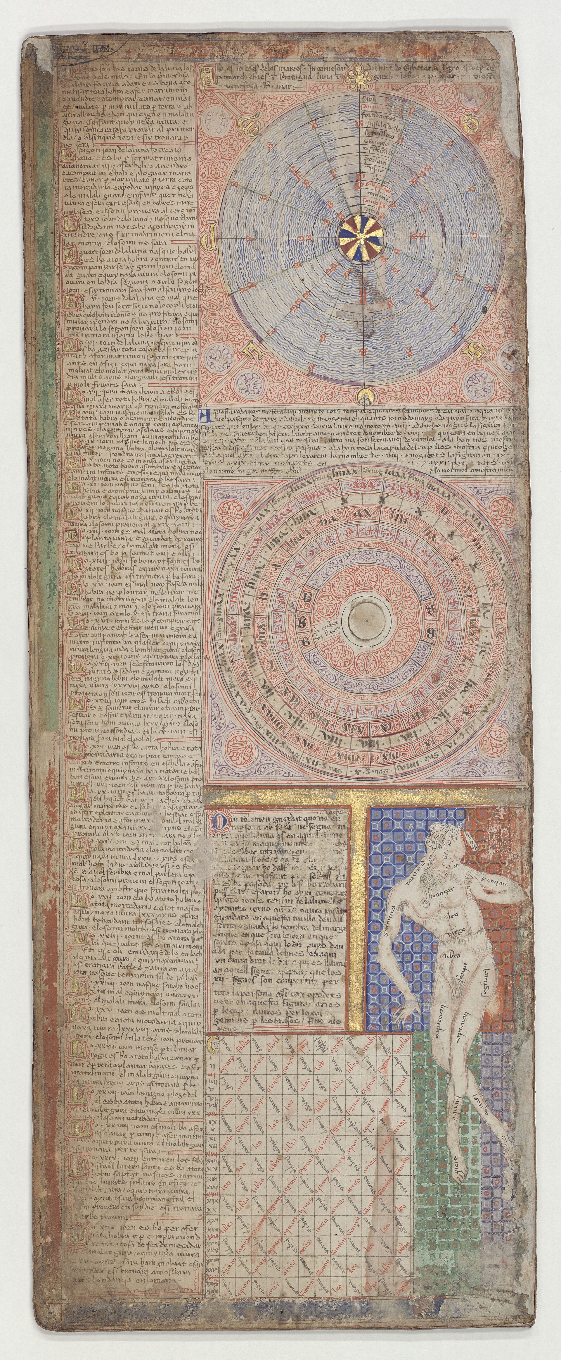
The same double leaf carries a tide diagram, a wheel for computing the movable feasts, a zodiac man and a lunar table. A long column lists the days of the moon, good and bad. The first day of the moon, it says, is the day Adam was created and is good for beginning every work, for marrying, for buying and selling, for travelling by sea or land and for building; the sick who fall ill that day will recover. The second is Eve's, good for marrying and for the vintage. The third is the day Cain was born and is bad for buying, selling or marrying, and the sick person will die. The fourth is Abel's. Genesis has thus been laid over a table of practical forecasts.
The zodiac man carries a legend that begins 'Diu Tolomeu', Ptolemy says: do not touch the part of your body governed by the moon's sign with iron, and do not be bled while the moon is in that sign. A table of the twelve signs follows, each with its element, its planetary house and a rule for bleeding and medicine. In Aries, hot and dry, of the nature of fire and the house of Mars, bloodletting and medicine are good but the head is not to be treated; in Taurus, cold and dry, of earth and the house of Venus, bloodletting and medicine are not good and the neck is left alone. Whether anyone at the French court followed a rule of this sort from this sheet is not documented, but the function is plain: it is a calendar for scheduling the surgeon.
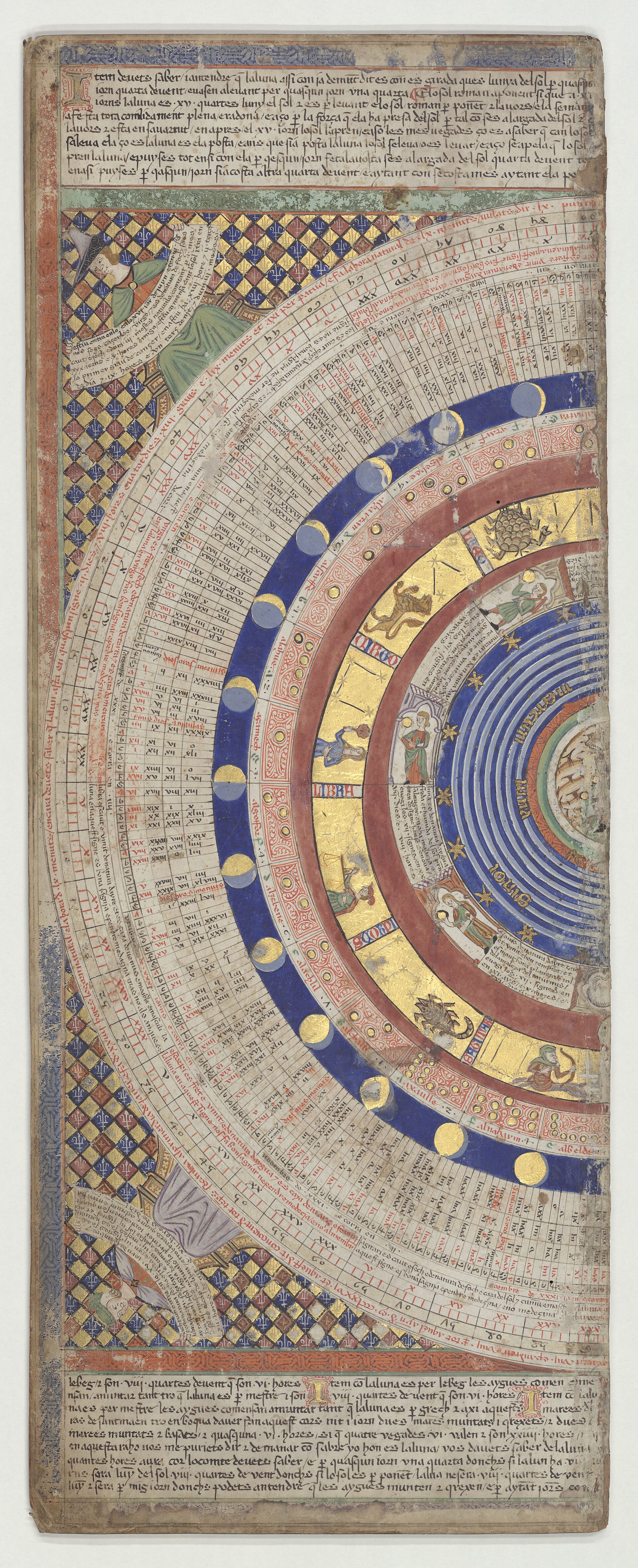
The second leaf is dominated by the great circular calendar, thirty-seven concentric bands in the count of Buchon and Tastu and of Liscak: the earth at the centre, the elements, the seven planets, the signs of the zodiac, the nineteen-year cycle of the golden number and a long run of lunar tables. A figure at each corner holds a scroll; the grounds behind them are chequered in red and blue with fleurs-de-lis. The calendar is where 1375 is written. The BnF adds that one of the quadrants of the diagrams once carried a movable needle, now lost; Tastu likewise remarks that a figure acted as the hand on a watch dial and that this fragile ornament has gone.
Nothing in these leaves points to a concealed doctrine. A tide table, a calendar, an Easter wheel, bloodletting rules and the days of the moon were the ordinary equipment of a courtly book of the time, and the king's library was full of such works. The absence of anything hidden is itself a finding, and the interest of the leaves is that a luxury object of the highest order carries working knowledge for physicians, sailors and clergy at the front of a map.
Chapter 7A Majorcan sailing chart stretched until it covered a world
The coastal drawing of the four map leaves belongs to a Majorcan tradition already visible in the chart signed in 1339 by Angelino Dulcert, whose inscription reads 'Hoc opus fecit Angelino Dulceri...
The coastal drawing of the four map leaves belongs to a Majorcan tradition already visible in the chart signed in 1339 by Angelino Dulcert, whose inscription reads 'Hoc opus fecit Angelino Dulceri, Anno M.CCC.XXXVIIII, de mense Augusto, in civitate Majoricarum'; the BnF says the western part of the Atlas shares the cartographic habits of the Majorcan charts already present there. What changed was the extension. The BnF calls the Atlas a work half-way between the sailing charts, criss-crossed by their rhumb lines, and the mappaemundi, and describes its image of Asia as very innovative. Liscak suggests a reason for the rectangular format: the cartographer cut an east-west strip out of a circular world map to cover only the Orient and the western ocean, perhaps because the prince who ordered it cared about those parts, so the shape cannot be read as evidence of ideas about the extent or shape of the earth, and the author, as an astronomer, certainly accepted its sphericity. That is Liscak's reading; no contract confirms the patron's wishes.
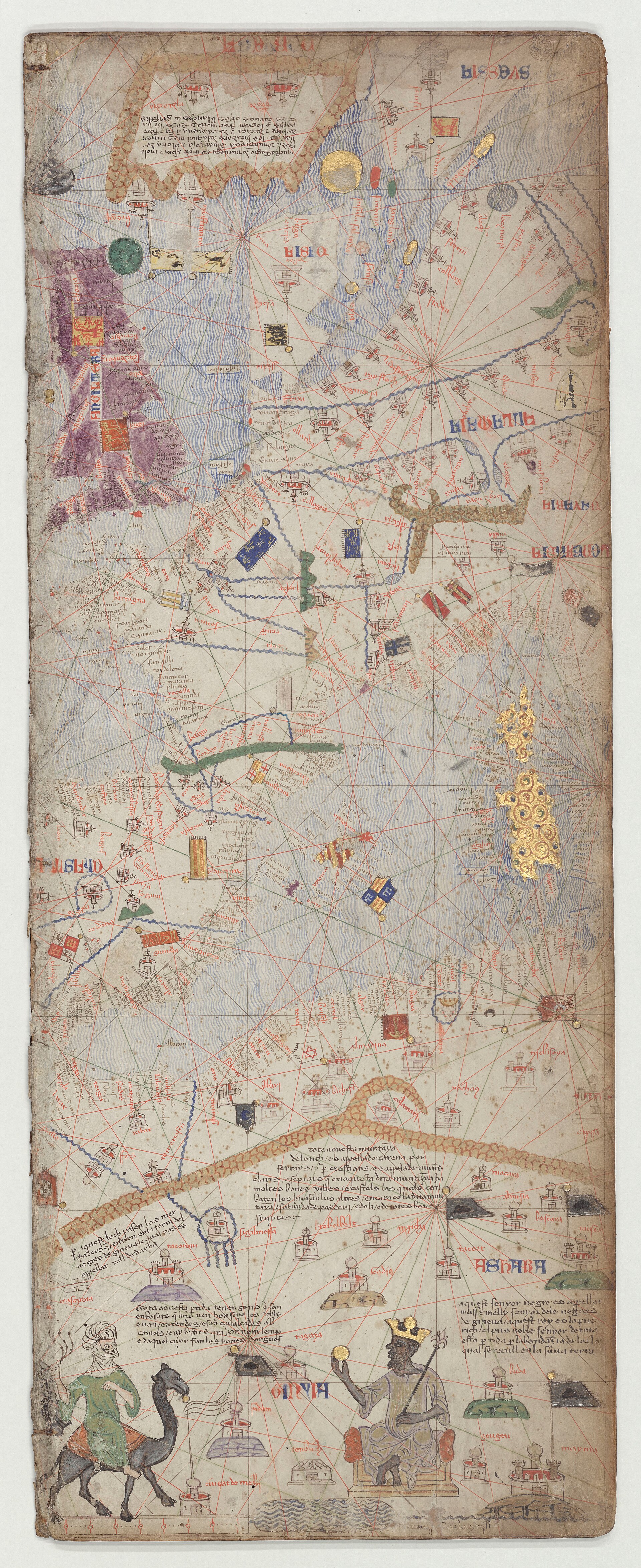
At the western end the wind rose in the Atlantic, with eight points named in Italian-looking forms (tramontana, grego, levante, laxaloch, merzodi, labetzo, ponente, magistro), is described by the BnF catalogue as one of the first compass roses on a sailing chart and by the BnF's older English page as the first. Next to it a long legend on the Fortunate Isles gives Isidore's reasons for the name and Pliny's account of an island where fruit grows unplanted, then says the pagans of the Indies believe the souls of their dead go there to live on the scent of the fruit, and adds that the truth is a fable. The mythical island of Brazil is drawn nearby. A small ship flying the arms of Aragon is labelled as the vessel of Jaume Ferrer, which left on 10 August 1346, the feast of St Lawrence, for the River of Gold; the BnF notes that the Majorcan seafarers hoped for a sea route round the Atlas Mountains to the gold and ivory of the African interior.
Other legends show the encyclopedic habit. Hibernia has islands where no one dies and none is born; Shetland or Iceland speaks the language of Norway; the island of Archania has six months of night-light and six of day-dark; the Baltic freezes from mid-October to mid-March hard enough to cross by ox-cart. The BnF's catalogue draws attention to one structural oddity: Corsica and Sardinia are drawn twice, on two successive leaves, creating an overlap in the middle of the Mediterranean that does not recur in the Asian part.
Chapter 8Musse Melly, the sand route and the gold the map was drawn to find
On the lowest part of the western leaf a crowned and enthroned black king holds a piece of gold in one hand and a sceptre ending in a fleur-de-lis in the other.
On the lowest part of the western leaf a crowned and enthroned black king holds a piece of gold in one hand and a sceptre ending in a fleur-de-lis in the other. The legend, in the English of the Cresques Project translation, says that this black lord is called Musse Melly and is the sovereign of the land of the black people of Gineva, and that he is the richest and noblest of all these lands because of the abundance of gold taken from his territory. The Project's own glosses differ on the place name, giving Ghana in one note and Guinea in another; the BnF reads the king as Mansa Musa of Mali. Musa reigned about 1312 to about 1337, made his pilgrimage to Mecca in 1324-25, and was by the later 1370s long dead; the legend is in the present tense. Hadrien Collet's 2022 book on the Mali sultanate, in the way the English Wikipedia summarises it, treats this legend as an early stage in the European making of the myth of Musa's unmatched wealth, and notes that the legend itself calls him richest of 'these lands', not of the world.
The map's knowledge of the Sahara is real. Liscak, following Grosjean, notes that the atlas marks the stages of the routes from Morocco to the Niger: Sigilmessa (Sijilmasa), Tebelt, Tagaza (Taghaza) and Tenbuch (Timbuktu). A legend names the pass through which merchants enter the land of the Black people, the valley of Darcha. A veiled rider on a camel, a Sanhaja Berber, is accompanied by a legend about veiled nomads who live in tents and ride camels, and an animal called lemp whose hide makes good shields. Another figure, the king of Organa, is a Saracen said to be constantly at war with the Saracens of the coast. No medieval African state called Organa is known. Obayemi (1980) and Blier (2012) identify it with the rulers of Ife, whose title Ogane or Oghene they connect to the name; the traditional reading is Kanem, or the city of Ouargla misread as a country; Falchetta (2006) proposed Kanem-Bornu or Ghana. The BnF catalogue lists the king without identifying him, and Buchon and Tastu render the country as Orgam and offer no identification.
The map ends in the south where the coast reaches the Rio de Oro. It was drawn by people whose interest in this coast was commercial: the Atlas puts the ship of Jaume Ferrer there with a legend about the elephants whose ivory lies on the beaches. None of the legends translated by the Cresques Project for this part of the map cites an African informant; the names are caravan stages and the figures are drawn from what Mediterranean traders knew of the trade.
The motif outlived the Atlas. The chart of Mecia de Viladestes of 1413 carries a figure labelled Mussa Melli beside Timbuktu, and its maker had been apprenticed to Jafuda Cresques. That chart appears among the comparison plates of this record and is not the Catalan Atlas.
Chapter 9Asia as the books described it, with the dead still on their thrones
The BnF's catalogue notes that Peter IV and Joan I gathered many manuscripts of eastern travel, in particular Marco Polo, Odoric of Pordenone and Mandeville, and judges it probable that these books...
The BnF's catalogue notes that Peter IV and Joan I gathered many manuscripts of eastern travel, in particular Marco Polo, Odoric of Pordenone and Mandeville, and judges it probable that these books, with the usual medieval authorities (Pliny, Solinus, Isidore, Honorius and the Alexander romance), inspired the Asian leaves. The map's own legends confirm the line. At the city of Lop the legend warns caravans, following Polo's desert story, that a rider who dozes will hear the voices of devils like those of his companions calling him by name. The great Khan is the most powerful prince of the Tartars, richer than any other emperor, guarded by twelve thousand horsemen in four companies of three months each. A long legend describes how the Khan, having learned by astrology that the city of Guatibalu would rebel, ordered it emptied and built Chambalech (Khanbaliq) beside it, twenty-four leagues round, with twelve gates and a bell after which no one dares walk the streets.
Several of the rulers drawn were dead long before 1375. The BnF notes that the Mongol prince north of the Caspian is identified with Jani Beg of the Golden Horde, who died in 1357, and that Rey Chabech is identified with Kebek Khan of the Chagatai line, who reigned 1309 to 1326; Liscak dates Kublai Khan to 1215-1294. The Asian leaves therefore carry rulers from several decades, which fits the BnF's remark that the Far Eastern place names seem to have been gathered from different sources and distributed at random. Japan does not appear on the map, and Liscak notes that the Malay peninsula and archipelago are missing while the Indian subcontinent is drawn in its peninsular form for the first time.
India shows how identifications diverge. The king of Colombo, a Christian, sits at the southern tip. Liscak concludes that this is Kollam on the south-west coast, drawn from the Franciscan Jordanus Catalani's Mirabilia descripta; the BnF record suggests that the figure is the sultan of Vijayanagar. A King Stephen, Christian, is placed by the legend where the body of St Thomas lies, facing Butifilis. A legend in the Near East says the king of Nubia is always at war with the Christians of Nubia, who are under the emperor of Ethiopia and the land of Prester John.
Biblical and legendary figures fill the interior. A legend marks the province of Tarsia, from which the three wise kings set out for Bethlehem, adding that they are buried at Cologne, two days from Bruges. The Queen of Sheba holds a nugget in the BnF's description, and a legend adds that Arabia Sheba now belongs to the Saracens and has myrrh, frankincense and a phoenix. At Mecca the legend says Muslims travel from every region to see what the English translation renders as the 'arch of Mohamed', and that after seeing so fine a thing they say they are not worthy to see anything else, and so empty their eyes in his honour; the BnF notes a kneeling Muslim pilgrim in prayer before the city. On the eastern islands the BnF's catalogue sees a rationalised bestiary: giants of Taprobane who eat white men, sirens in the sea, naked fish-eaters of the type Pliny and Solinus called Ichthyophagi, and pygmies fighting cranes, shown in a more plausible, cruder form than the older monsters.
Chapter 10A sacred order laid over the trade routes: Genesis at one end, the Last Judgement at the other
The BnF catalogue entry, written by Emmanuelle Vagnon and Marie-Pierre Laffitte and updated by Veronique de Becdelievre, reads the layout as an argument.
The BnF catalogue entry, written by Emmanuelle Vagnon and Marie-Pierre Laffitte and updated by Veronique de Becdelievre, reads the layout as an argument. The book begins with the creation and the calendar, then runs to the far east, where the world ends in space and in time: the prince of Gog and Magog, shut behind the Caspian mountains by Alexander according to the legend, and the Antichrist, who the legend says will be raised in Galilee and preach in Jerusalem at thirty, claiming to be Christ and rebuilding the Temple. The Last Judgement appears beside them. At the opposite pole, in the Atlantic, the Fortunate Isles are named in the legend as the place the pagans took for paradise. The catalogue concludes that the circle of the mappamundi joins beginning and end, east and west, earthly paradise and Last Judgement, despite the linear reading order.
The catalogue adds that the Orient is a mission field before it is a market. A legend quotes Isaiah on survivors sent to far peoples and islands that have never heard the Lord's name, who will proclaim his glory. The same eastern leaves hold the apostle Matthew's tomb with the Armenian monks, King Stephen at St Thomas's grave, the Magi and the cross-topped cities of Christians. The catalogue ties this to the diplomacy of the day, which it calls 'tout entiere tournee' toward taking from behind the Muslims who monopolised the spice trade; that is the catalogue authors' interpretation of the context, and no legend on the map says it. Nor does any document fetched here say what Cresques Abraham, who was a Jew, thought of the Christian eschatology that appears on a map made in his workshop; the colophon of the Farhi Bible, in the BnF's translation, shows only that he made a Hebrew Bible for himself.
Two further readings sit alongside this. Kogman-Appel's book, in the publisher's words, 'focuses on the Jewish aspects' of Elisha Cresques's career, his professional profile and his scholarship, and the reviewer Jacques Paviot (Francia-Recensio, 2021) credits it with recreating the intellectual and religious milieu of a Majorcan Jew shaped by Jewish, Christian and Muslim influences. Riera, quoted in the BnF catalogue, takes the title 'compass-maker and master of mappaemundi' to mean that Cresques's chief activity was painting, not cartography or compass-making, and still less the astrology or mathematics sometimes attributed to him. The Atlas is graded here accordingly: the documented content is a cosmography, an astro-medical calendar and a map filled with encyclopedic, travel and biblical material; the sacred-history reading is argued by the BnF authors; and no hidden or private doctrine is claimed by any source consulted.
Chapter 11After 1424: a gap, a binder and a catalogue number
In April 1424, after the death of Charles VI, three booksellers appraised the Louvre library for Garnier de Saint-Yon: 843 volumes valued at 2,323 livres 4 sous parisis.
In April 1424, after the death of Charles VI, three booksellers appraised the Louvre library for Garnier de Saint-Yon: 843 volumes valued at 2,323 livres 4 sous parisis. The Duke of Bedford, regent for the English, took possession on 22 June 1425; Delisle reports that the account shows 1,200 livres in cash handed over, to help pay for the tombs of the dead king and queen, and that Bedford probably sent the best of the books to England or to Rouen. The Atlas, appraised at four livres, was in the library so appraised. The BnF says it is listed in the Louvre library until the library's dispersal; it does not say where the Atlas went.
The BnF rejects two candidate sightings. A mappamonde in the library of Jean de Berry, valued at 5 livres tournois in 1413 and 1416, belonged to the duke already then and is not this object. The numbers 335 in the 1518 inventory of Blois and 1763 in that of 1544, which E. Pognon read as the Atlas, correspond more probably to Louis XII's small atlas of sea charts, Latin 4850, of seven leaves, not six. The Atlas is also absent from Rigault's inventory of 1622. Between 1425 and the next solid evidence nothing places it, other than its binding: the white leather of Charles V's time was replaced at the Paris workshop of Simon Vostre, which the BnF dates to about 1515, indicating that it was then in Paris.
It appears clearly in the catalogue of Nicolas Clement, keeper of the royal library under Louis XIV, compiled in 1682 as number 6816, 'Anciennes cartes cosmographiques avec l'explication en catalan'. The number 6816 is not written on the volume. The inner cover bears Supplement francais 1191, a mistaken marking probably of the July Monarchy, later corrected and given to a French William of Tyre; by 1892 Alfred Morel-Fatio inventoried it among the Spanish manuscripts as number 119, and it is now Espagnol 30. During the Revolution or the Consulate the leather was repaired by the Paris binder Durand or his son in 1797 or 1803, with the cipher BN and RF stamped on the covers; Tastu reads the letters at the four corners as R.F. and N.B., Napoleon Bonaparte. The alphabetical table appended to the notice, drawn up by a hand other than Buchon's, states that modern geographers knew the Atlas only from about 1803.
Chapter 12Printed, traced and scanned: how the Atlas reached its readers
Buchon and Tastu's notice is the first scholarly edition: a transcription and French translation of every legend with notes, in Notices et extraits des manuscrits, volume XIV, part 2.
Buchon and Tastu's notice is the first scholarly edition: a transcription and French translation of every legend with notes, in Notices et extraits des manuscrits, volume XIV, part 2. The offprint's title page reads Imprimerie royale, Paris, 1839; the BnF's bibliography dates the volume 1842 (pages 1 to 152). Delisle adds that it came with a lithographic facsimile and that an heliographic reproduction appeared in the Choix de monuments geographiques of 1883. Their introduction states the claim for the object's rank: 'On ne connait pas, en France, de manuscrit plus ancien, ni plus complet sur l'etat du globe avant la decouverte de l'Amerique.' They arranged the six leaves into two tables of cosmography and four maps and began the maps with the westernmost leaf, the one with the wind rose, which is the reverse of the BnF's present reading order.
Edmond Hamy's 1891 note on Cresques the Jew tied the maker to the documents and, per the BnF, separated the 1381 letters from the Atlas. Nordenskiold's Periplus of 1897 is listed in the BnF's bibliography for it, and Delisle gave it its place among the library's surviving manuscripts in 1907. The sixth centenary of 1975 produced the great facsimiles: Diafora in Barcelona at 1:1 scale in 1,500 copies, bilingual in Catalan and Spanish, with studies by Llompart, Moll, Riera and others; Grosjean's edition at Urs Graf in Dietikon in German in 1977 and English in 1978, with a Spanish edition by Ebrisa in 1983; a CD-ROM in 1999; and bibliophile editions of 2005 and 2008 by Enciclopedia Catalana and the Institut Cartografic de Catalunya. Kogman-Appel's book of 2020 includes a fold-out print of the Atlas.
Today the images are open to anyone. The BnF digitised the original in high definition in 2017; Gallica gives it as public domain, as part of its collection on the royal library of Charles V, with a IIIF manifest of 18 images, each roughly 6,400 by 15,800 pixels, covering the upper and lower boards and sixteen views. The Cresques Project's English translation of the legends, which this record uses, is based on the 1975 Diafora facsimile and the BnF's scans. The BnF's older English page and its exhibition site 'Le Ciel et la Terre' provide a commentary, though only the page description of the latter could be read for this record.
Chapter 13What it was worth: three sums, a valuation and no sale
No sale of the Atlas is recorded. It passed from the Louvre library to the royal library and the BnF without any source reporting an auction, a private sale, an export licence, a tax settlement or a...
No sale of the Atlas is recorded. It passed from the Louvre library to the royal library and the BnF without any source reporting an auction, a private sale, an export licence, a tax settlement or a dispute over title, so there is no hammer price or premium to separate, and the auction fields of this record are left empty on purpose. Three sums appear in the documents, and none is a price paid for this object.
The first is the payment of 20 March 1382: 150 Aragonese gold florins to Cresques Abraham for certain tablets bearing the figure of the world. The second is the payment of 1387: 60 livres 8 sous to Jafuda Cresques for a mappa mundi begun two years earlier by Abraham, in Majorcan pounds according to Liscak citing Porcel, though the BnF does not give the currency. Riera, quoted in the BnF catalogue, observes that the price of the works ordered from Cresques has nothing in common with the prices of the sea charts otherwise mentioned in Catalan archives. No source fetched gives the exchange rate between florin and livre, so the two sums are not compared with each other or turned into modern money here.
The third is the only figure attached to the object itself: four livres parisis in 1424. In that year the three appraisers put 843 volumes at 2,323 livres 4 sous parisis, an average of about 2.76 livres a volume, so the Atlas was about 0.17 per cent of the library. Other volumes show the range: a French Livy at 60 livres, others at 16, 8 and 5 livres, and one at 8 sous. For a frame in labour, Delisle records a daily wage of two sous parisis for the royal illuminator Jean Susanne in 1350, with 100 sous a year for his robes, and four sous a day for a scribe of the king's books in 1364. At twenty sous to the livre, four livres is 80 sous, or forty days of the illuminator's 1350 daily wage or twenty days of the scribe's 1364 wage. The method is a ratio of nominal money in the same unit; the wages date from 74 and 60 years before the appraisal and no deflator is applied, so the result gives an order of magnitude only. The 1424 figure is also an appraisal for the dispersal of a dead king's library under an English regent, and not the cost of making the Atlas or a market price. Jean de Berry's mappamonde, valued at 5 livres tournois in 1413 (a different unit from the livre parisis), sits at a comparable level.
Chapter 14What is happening to it now
As of this record the BnF classes access to the original as exceptional: it requires a reasoned request and the authorisation of the head of the Department of Manuscripts, and readers are asked to...
As of this record the BnF classes access to the original as exceptional: it requires a reasoned request and the authorisation of the head of the Department of Manuscripts, and readers are asked to consult a substitute copy first. The 1991 restoration renewed the leather of the cover and put a modern BN stamp on the manuscript. In 2018 the paintings were the subject of physico-chemical analyses by the BnF's scientific laboratory, filed as dossier BnF RIL 2018-014; no published results were found among the sources consulted. The catalogue lists as an exhibition reference the catalogue of the BnF show L'age d'or des cartes marines (23 October 2012 to 27 January 2013) and, in its bibliography, the 1998 Couleurs de la Terre catalogue; the sources fetched do not say whether the original was shown, and no later display was verified. Gallica's OAI record carries a datestamp of 21 August 2025. No conservation programme, loan, litigation or sale is reported in the sources fetched; web search was unavailable for this record, so recent news was not checked.
The artist
Cresques Abraham (liturgical name Elisha ben Abraham Cresques), with his son Jafuda (Jehuda) Cresques, called Jaume Ribes after 1391
The maker of the Catalan Atlas is a man defined by archive entries and a Hebrew colophon, not by a signature. Cresques Abraham, a Jew of Palma, was compass-maker and master of mappaemundi to the kings of Aragon in the 1360s, 1370s and 1380s, and his son Jafuda continued the workshop after his death. No chart or map signed by either survives, so every attribution to them, including the one on this record, is an argument from documents about their work to an unsigned object.
Exhibited
- 2012-2013L'age d'or des cartes marines. Quand l'Europe decouvrait le monde (the BnF entry lists the exhibition catalogue; whether the original was displayed is not stated)Bibliotheque nationale de France, Paris
Literature
- Buchon, J. A. C. and Tastu, J., Notice d'un atlas en langue catalane, Notices et extraits des manuscrits, vol. XIV, part 2, pp. 1-152 (offprint Imprimerie royale, 1839) (1839-1842)
- Hamy, E.-T., Cresques lo Juheu, note sur un cartographe juif catalan de la fin du XIVe siecle, Bulletin de geographie historique et descriptive, pp. 218-222 (1891)
- Delisle, L., Recherches sur la librairie de Charles V, vol. 1, pp. 128-129 and 276-277 (1907)
- El Atlas Catalan de Cresques Abraham, Barcelona, Diafora (facsimile with studies by Llompart, Moll, Riera and others) (1975)
- Grosjean, G., Mapamundi. Der katalanische Weltatlas vom Jahre 1375, Dietikon-Zurich, Urs Graf (English edition 1978) (1977)
- Estow, C., Mapping Central Europe: The Catalan Atlas and the European Imagination, Mediterranean Studies 13, pp. 1-16 (2004)
- Liscak, V., Mapa mondi (Catalan Atlas of 1375), Majorcan cartographic school, and 14th century Asia, Proceedings of the International Cartographic Association 1 (2017)
- Kogman-Appel, K., Catalan Maps and Jewish Books: The Intellectual Profile of Elisha ben Abraham Cresques (1325-1387), Turnhout, Brepols (2020)
Related works
| Work | Relation | Where it is |
|---|---|---|
| Chart of Angelino Dulcert, 1339 Angelino Dulcert (Dalorto) | Earliest dated Majorcan chart; the BnF says the western half of the Atlas shares its cartographic habits Inscribed 'Hoc opus fecit Angelino Dulceri' in August 1339 at Majorca; recovered by a Paris collector in 1885 (Delisle). | Bibliotheque nationale de France, Paris (Gallica btv1b7759104r) |
| Paris chart, Res. Ge. AA 751 Anonymous, grouped with the 'Cresques workshop' | The chart Campbell finds closest to the Atlas in features (gold Isle of Man, stripes over Majorca) Dated about 1400; not signed; one of the five charts Pujades grouped with the Atlas. | Bibliotheque nationale de France, Paris |
| Venice, Naples, Florence and Istanbul charts Anonymous, grouped with the 'Cresques workshop' | Rest of the group of charts attributed tentatively to the same atelier Dates between 1375 and 1400 are estimates; none is signed. | Biblioteca Marciana, Venice (It. IV, 1912); Biblioteca Nazionale, Naples (XII.D.102); Biblioteca Nazionale Centrale, Florence (Portolano 22); Topkapi Palace, Istanbul (fragments of a mappa mundi) |
| Chart of Mecia de Viladestes, 1413 Mecia de Viladestes (Samuel Corcos) | By a former apprentice of Jafuda Cresques; includes a figure of Mussa Melli and Timbuktu This is NOT the Catalan Atlas; it appears among the comparison plates of this record. | Bibliotheque nationale de France, Paris (CPL GE AA-566 RES) |
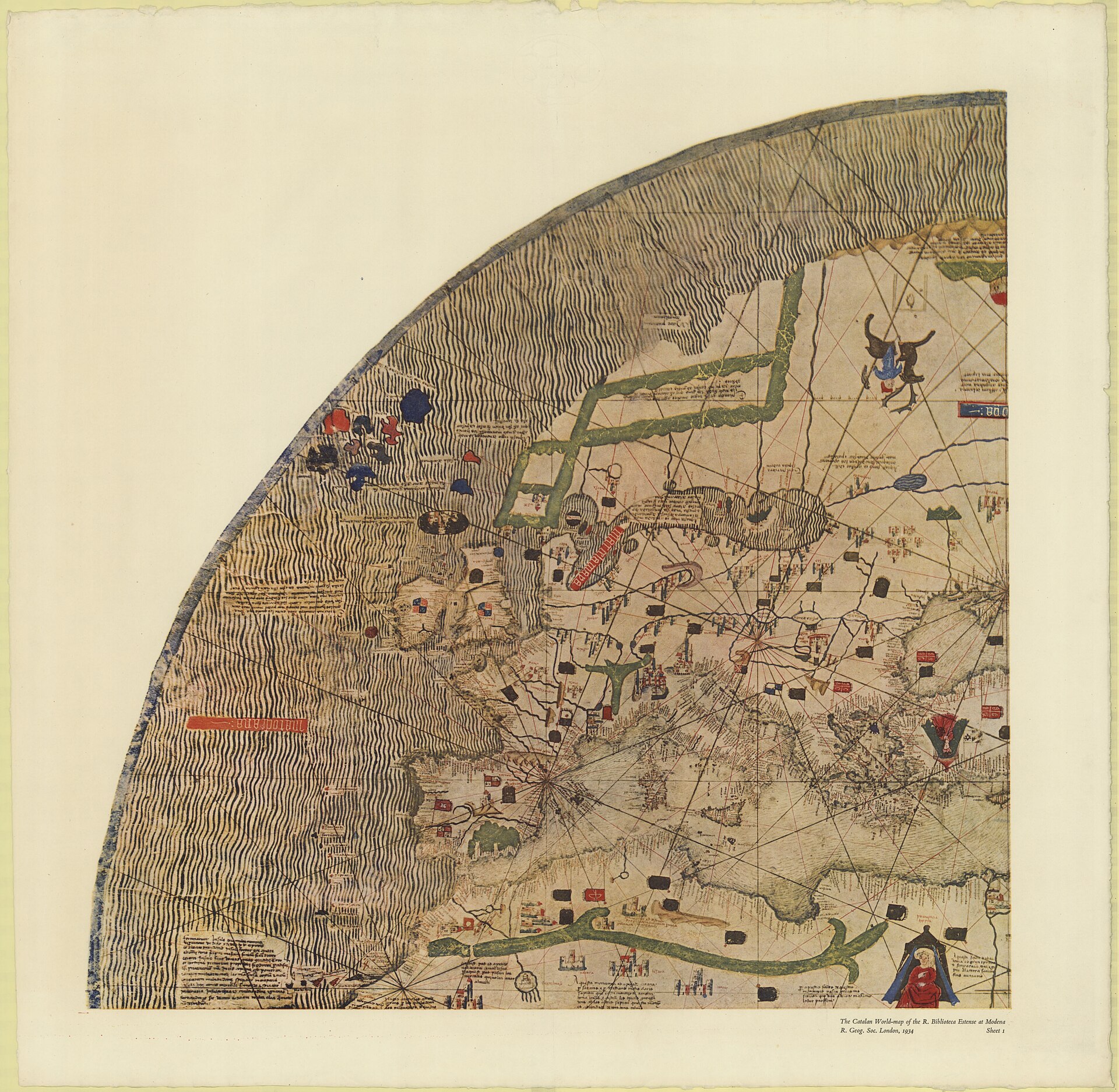
| Catalan-Estense world map Attributed to Petrus Roselli | Later Catalan world map, circular, in the same portolan-plus-mappamundi tradition Assigned to c. 1450-60; Campbell proposes c. 1462-64 and Roselli. Not the Catalan Atlas. | Biblioteca Estense, Modena (C.G.A.1) |
| Fra Mauro's World Map Fra Mauro | Venetian monastic mappamundi of c. 1450, heir to the same mixture of travel literature and sailing-chart outlines A separate record in this archive; not a version of the Catalan Atlas. | Biblioteca Nazionale Marciana, Venice |
| The Genoese World Map of 1457 Anonymous | Later hybrid portolan-and-mappamundi world map that this archive's record cites the Catalan Atlas as an ancestor of A separate record in this archive; more than eighty years later and from a different regional school. | Biblioteca Nazionale Centrale, Florence |
| Hereford Mappa Mundi Anonymous | Great mappamundi of c. 1300 in the older sacred-history tradition whose layout the BnF says the Atlas follows in spirit A separate record in this archive. | Hereford Cathedral |
| Farhi Bible Elisha ben Abraham Cresques | Hebrew Bible completed 19 November 1382 by the man the BnF and Kogman-Appel identify with Cresques Abraham Shares ornament with the Atlas (carpet-page borders, chequered grounds, tents). | Not stated in the sources consulted |
Open questions
- Who ordered the Atlas, for whom, and how did it reach Charles V's library before 6 November 1380? No contract, receipt or letter naming this object has been published; the letters of 5 November 1381 concern another map.
- What became of the mappemonde that Joan of Aragon sent to Charles VI through Guillaume de Courcy in November 1381, and is it one of the surviving Cresques-group objects?
- How was the work divided between Abraham and Jafuda, and which hand painted which leaf? The only documented work of Jafuda is a different mappa mundi, paid for in 1387.
- Where was the Atlas between the 1424-25 sale of the Louvre library and the binding of about 1515, and who owned it? The BnF excludes the Berry and Blois sightings.
- Who or what is the king of Organa: Kanem, Ouargla, Ife or Ghana, as four published readings hold? The BnF and the first editors leave it unidentified.
- What did the 2018 pigment and materials analyses by the BnF laboratory (dossier RIL 2018-014) show, and do they bear on the date or the workshop?
- Why do 1376 and 1377 appear beside 1375 in the calendar, and was the book finished in 1375 or later in the decade? Tastu argued for completion in 1376-77.
- Was Jafuda Cresques the Mestre Jacome of Henry the Navigator's Portugal? Reparaz said yes in 1930; the BnF and recent literature say he was dead by 1410.
- No insurance, declared or customs valuation of the Atlas was found, and the sources fetched do not say whether the original has been displayed since the 2012-13 exhibition listed in the BnF entry.
Questions about this object
What is The Catalan Atlas?
The Catalan Atlas is a map, dated c. 1375 (calendar computed from 1375, with 1376 and 1377 announced; in the Louvre library by 6 November 1380; Gallica gives 1370-1380). Medium: Pen and brush with opaque colours, burnished gold and burnished silver on parchment, pasted on wooden boards, in a Parisian calf binding of c. 1515.
Who made The Catalan Atlas, and is the attribution settled?
The attribution to Abraham Cresques is recorded here as disputed. Attributed to Cresques Abraham of Palma, master of mappaemundi and compass-maker, with his son Jafuda (Jehuda). The BnF titles it 'Abraham Cresques ?'. The attribution rests on archive documents about Cresques's mappaemundi and on stylistic kinship with the Hebrew Farhi Bible, not on a signature; the BnF concludes it was made if not by him then in his close circle. Campbell calls it the only work confidently, though not conclusively, assigned to Cresques Abraham. Whether Abraham or Jafuda drew which leaves is undocumented.
Where is The Catalan Atlas now?
Bibliotheque nationale de France, Departement des Manuscrits, Paris. Inventory number Espagnol 30 (formerly Supplement francais 1191 by mistake; Regius 6816; Espagnol 119 in 1892). Last confirmed 8 October 2026. BnF Archives et manuscrits catalogue entry (updated July 2018) and Gallica record; consultation of the original is exceptional and needs the authorisation of the head of the department.
What is still unknown about The Catalan Atlas?
Who ordered the Atlas, for whom, and how did it reach Charles V's library before 6 November 1380? No contract, receipt or letter naming this object has been published; the letters of 5 November 1381 concern another map.
Sources
- 1Bibliotheque nationale de France, Archives et manuscrits: catalogue entry for Espagnol 30, 'Abraham Cresques ? Atlas de cartes marines, dit [Atlas catalan]' (notice by Emmanuelle Vagnon and Marie-Pierre Laffitte, updated by Veronique de Becdelievre, July 2018). Primary institutional catalogue: shelfmarks, physical description, binding, inventories of 1380, 1411, 1413 and 1424, documents on Cresques Abraham, bibliography. archivesetmanuscrits.bnf.fr/ark:/...
- 2Gallica / BnF OAI-PMH record for the digitised Espagnol 30 (title, date 1370-1380, rights 'domaine public', high-definition digitisation 2017, Gallica corpus RegiaCharlesV, contributors). oai.bnf.fr/oai2/...
- 3Gallica IIIF presentation manifest for Espagnol 30 (18 canvases: upper board, 16 views, lower board; shelfmark, creator, place of copy). gallica.bnf.fr/iiif/...
- 4BnF Enluminures, 'The Catalan Atlas' (English-language page, Internet Archive capture of 6 February 2008): description of leaves, orientation, wind rose, contents of the Asian leaves. web.archive.org/web/...
- 5BnF exhibition site 'Le Ciel et la Terre: l'Atlas catalan' (Internet Archive capture of 13 August 2024; only the page title and the site's meta description were readable, the content pages are frames and image maps). web.archive.org/web/...
- 6Leopold Delisle, Recherches sur la librairie de Charles V, vol. 1 (Paris: H. Champion, 1907): the inventories of 1373-1424, the keeper Gilles Malet, the appraisal of 1424, the Apercu sommaire of the library, catalogue entry LXXIV (Atlas catalan). Full text via the Internet Archive. archive.org/details/...
- 7J. A. C. Buchon and J. Tastu, 'Notice d'un atlas en langue catalane, manuscrit de l'an 1375, conserve parmi les manuscrits de la Bibliotheque royale sous le numero 6816' (Imprimerie royale, Paris; offprint dated 1839 from Notices et extraits des manuscrits, vol. XIV part 2). First scholarly edition: transcription, French translation, notes. Scan on Wikimedia Commons. upload.wikimedia.org/wikipedia/...
- 8Clara Estow, 'Mapping Central Europe: The Catalan Atlas and the European Imagination', Mediterranean Studies 13 (2004), pp. 1-16 (footnotes 5, 7, 8, 15 on the documents of 1373, 1379 and 1381). PDF hosted by Yale's Iberian Connections project. iberian-connections.yale.edu/wp-content/...
- 9Vladimir Liscak, 'Mapa mondi (Catalan Atlas of 1375), Majorcan cartographic school, and 14th century Asia', Proceedings of the International Cartographic Association 1 (2017), peer reviewed, CC BY 4.0. Summarises Grosjean 1977, Galera i Monegal 2016 and others. proc-int-cartogr-assoc.net/1/...
- 10Tony Campbell, 'Anonymous works and the question of their attribution to individual chartmakers or to their supposed workshops' (Map History / History of Cartography, mounted 7 March 2011, with later dated corrections): the Cresques group, Viladestes's apprenticeship, the Catalan-Estense map. maphistory.info/PortolanAttributions.html
- 11The Cresques Project, 'Catalan Atlas Legends: Panel III' (English translations of the legends, based on the 1975 Diafora facsimile; Atlantic, north-west Europe, West Africa). cresquesproject.net/catalan-atlas-legends/...
- 12The Cresques Project, 'Catalan Atlas Legends: Panel IV' (Europe east, Near East, Nubia, Sinai). cresquesproject.net/catalan-atlas-legends/...
- 13The Cresques Project, 'Catalan Atlas Legends: Panel V' (Persia, Arabia, Golden Horde, India). cresquesproject.net/catalan-atlas-legends/...
- 14The Cresques Project, 'Catalan Atlas Legends: Panel VI' (Central Asia, Cathay, Gog and Magog, the eastern seas). cresquesproject.net/catalan-atlas-legends/...
- 15Brepols publisher page for Katrin Kogman-Appel, Catalan Maps and Jewish Books: The Intellectual Profile of Elisha ben Abraham Cresques (1325-1387) (Turnhout, 2020), with abstract and review excerpts. brepols.net/products/...
- 16Encyclopaedia Judaica entry 'Cresques, Abraham' (reproduced at encyclopedia.com). encyclopedia.com/religion/...
- 17Wikipedia, 'Catalan Atlas' (English). en.wikipedia.org/wiki/...
- 18Wikipedia, 'Atlas catalan' (French). fr.wikipedia.org/wiki/...
- 19Wikipedia, 'Abraham Cresques' (English). en.wikipedia.org/wiki/...
- 20Wikipedia, 'Jehuda Cresques' (English). en.wikipedia.org/wiki/...
- 21Wikipedia, 'Mansa Musa' (English). en.wikipedia.org/wiki/...
- 22Wikipedia, 'Charles V of France' (English). en.wikipedia.org/wiki/...
- 23Wikimedia Commons file page 'Catalan Atlas BNF, sheet 6.jpg' (Gallica source btv1b55002481n, PD-Art; the Commons 'sheet' numbers follow Gallica's views and are not the leaf numbers used by the BnF catalogue). commons.wikimedia.org/wiki/...

Last verified · Published
Change log
9 November 2026 - Record created at the house standard: researched narrative, technical evidence, maker dossier, graded provenance chain, prices with hammer and premium separated, related works, open questions and sources.