Itinerary from London to the Holy Land
Matthew Paris · c. 1250-1259
Last verified 14 September 2026 · 16 sources cited · Change log
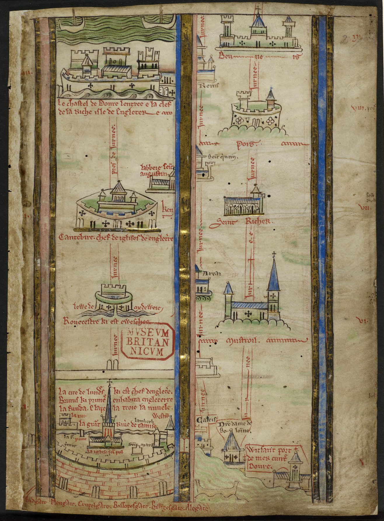
The opening folio of the itinerary, covering the journey from London to Beauvais. Verified against the British Library's own catalogue description of Royal MS 14 C VII, ff. 1v-8r, which places an itinerary from London to the Holy Land at exactly ff. 2r-5r.
| Artist | Matthew Paris |
|---|---|
| Date | c. 1250-1259 |
| Medium | Pen and ink line drawing with tinted colour washes and gold leaf on parchment |
| Dimensions | Folio dimensions not published in the sources consulted. The itinerary occupies four folios (ff. 2r-4r and 4v-5r) within an eight-folio prefatory quire (ff. 1v-8r) bound before the text of the Historia Anglorum. |
| Where it is now | British Library, London, Royal MS 14 C VII, ff. 2r-5r (within the bound volume Royal MS 14 C VII)last confirmed 14 September 2026 |
| Attribution | acceptedAttributed to Matthew Paris on the standard authority of the British Library's own catalogue, which describes Royal MS 14 C VII as carrying two autograph copies of his historical works with their prefatory material, and on the long-standing paleographic attribution made by Richard Vaughan in his 1958 study of Paris's hands. Full note |
| Object type | Map |
| Period | English, mid-thirteenth century (Gothic) |
| Cases | Has a provenance gap |
| Inscriptions | Town names, captions and journey times in the Anglo-Norman French of the mid-thirteenth century; the surrounding prefatory quire also carries Latin. |
- Where it is now
- British Library, Londonlast confirmed 14 September 2026
- Attribution
- accepted
- Provenance
- 5 links3 documented, 2 unknown
- Sources
- 16 cited
- Last verified
- 14 September 2026Change log
On this page 9 sections
A strip map in pen, tinted colour and gold, drawn by or for the St Albans monk-chronicler Matthew Paris to preface his Historia Anglorum. It does not show a country. It shows a road: London up through Rochester, Canterbury and Dover, across the Channel, down through France and the Alpine passes into Italy, on to Rome, and south again to the Apulian ports of embarkation for the crusader states, with a further two folios carrying the reader on to Acre and Jerusalem itself.
It is one of at least four versions Paris drew of the same journey, and the manuscript that carries this one, Royal MS 14 C VII, has been in continuous institutional custody since it entered the English royal library, given to the nation by George II in 1757 and held by the British Library since 1973. Scholars now read it less as a practical road map than as an aid to a form of devotion St Albans' cloistered monks could not otherwise perform: a journey to Jerusalem made in the mind, one town at a time.
Where the picture, and the picture alone, has been asked to answer a question the sources cannot yet answer, this record says so rather than filling the gap: who owned the volume before 1757, and whether the hand that drew this particular copy was Paris's own or a later scribe's, are both left as open findings, not settled facts.
Provenance
Each link is graded. Documented: a cited source supports it. Disputed: the identification is argued but not established. Unknown: no owner for that span, and the gap is not smoothed into a narrative. The grades in the glossary.
- c. 1250 -Matthew Paris and the scriptorium of St Albans Abbeydocumented
Produced at St Albans Abbey, England, within the date range c. 1250-1259 assigned by the British Library to the prefatory quire that carries this itinerary. Whether the itinerary was drawn by Paris's own hand or, as Connolly argues, by a later scribe working within the same tradition, is a separate and unresolved authorship question recorded under attribution.12
- 13th century - by 1757Unrecordedunknown
No owner or custodial route is documented between the manuscript's production at St Albans and its presence in the Old Royal Library. St Albans Abbey was dissolved in 1539; how the volume passed from the abbey, or from whatever hands held it afterward, into royal ownership is not stated in the sources consulted.15
- unrecorded date - 1757The Old Royal Library, sovereigns of Englandunknown
The manuscript carries a Royal shelfmark, meaning it belonged to the roughly 2,000-manuscript Old Royal Library assembled by English sovereigns from the reign of Edward IV onward. The exact date and reign in which Royal MS 14 C VII specifically entered that collection is not established in the sources consulted.54
- 1757 - 1973The British Museum, Londondocumented
King George II gave the Old Royal Library, some 2,000 manuscripts including Royal MS 14 C VII, to the recently founded British Museum in 1757, four years after the Museum's foundation on the Cotton and Sloane collections.5
- 1973 - presentThe British Library, Londondocumented
The British Library was established as an independent institution in 1973, separating the national library's holdings, including the Royal manuscripts, from the British Museum. The manuscript has remained there since, catalogued as Royal MS 14 C VII.5
Technical evidence
| Attribution note | Attributed to Matthew Paris on the standard authority of the British Library's own catalogue, which describes Royal MS 14 C VII as carrying two autograph copies of his historical works with their prefatory material, and on the long-standing paleographic attribution made by Richard Vaughan in his 1958 study of Paris's hands. The attribution is not unanimous: Daniel Connolly, in his 2009 monograph on Paris's maps, argues from differences in script, spelling and the added gold decoration that this particular copy of the itinerary was made by a later, unidentified scribe, probably for a royal patron such as Edward I, rather than by Paris himself. This record follows the institutional and majority scholarly attribution while recording the dissent. |
|---|---|
| Support | Parchment, forming part of an eight-folio prefatory quire (ff. 1v-8r) bound before the text of the Historia Anglorum.1 |
| Medium and decoration | Pen and ink line drawing with tinted colour washes and gold leaf, in the pen-and-wash 'tinted drawing' technique Matthew Paris used throughout his chronicles rather than fully modelled miniature painting.2 |
| Extent of the itinerary | The itinerary occupies four folios: ff. 2r-4r for the leg from London to Apulia, and ff. 4v-5r for the continuation to the Holy Land, now mounted separately from their original conjugate leaves.2 |
| Language | Town names, captions and journey times in the Anglo-Norman French current in England in the mid-thirteenth century; the surrounding prefatory quire also carries Latin.1 |
| Physical construction | Flaps of parchment were stitched to pages in the sequence to carry additional drawn material and alternative routes, requiring the reader to physically handle and unfold the book rather than only look at it.16 |
| Companion prefatory content | Bound in the same quire, immediately before and after the itinerary: a diagram of the winds (f. 1v), Matthew Paris's separate map of Britain (f. 5v), a tinted drawing of the Virgin and Child with the author in prayer (f. 6r), Easter tables (f. 6v), and a calendar with St Albans feast days (ff. 7r-8r).1 |
| Digitisation status | As catalogued by the British Library, full digital images of Royal MS 14 C VII are listed as currently unavailable through the library's own Digitised Manuscripts viewer, though individual leaves (including f. 2 of this itinerary) have been separately released as photographs via British Library Images Online.28 |
Images
The record in full
A road, not a country
The object is a strip map: a sequence of walled towns strung along a drawn road, read from the bottom of the page upward, each town named, each linked to the next by a line marked with the number of days it took to travel between them. London sits at the bottom left. The road climbs through Rochester and Canterbury to Dover, crosses the Channel to Wissant, and forks toward Beauvais and the roads into France. It is not an attempt to show the shape of a country, the way a mappa mundi shows the shape of the world. It is an attempt to show a route, city by city, as a traveller or a reader would encounter it in sequence.
In the manuscript that carries this copy, British Library Royal MS 14 C VII, the itinerary occupies four folios at the very front of the book, ff. 2r-4r for the leg from London to Apulia and ff. 4v-5r for the continuation to the Holy Land, prefacing Matthew Paris's Historia Anglorum. The British Library's own catalogue describes these leaves as now mounted separately from their original conjugate pairs, meaning the map as it survives has been physically rebound and worked on since Paris's lifetime.
The prefatory quire
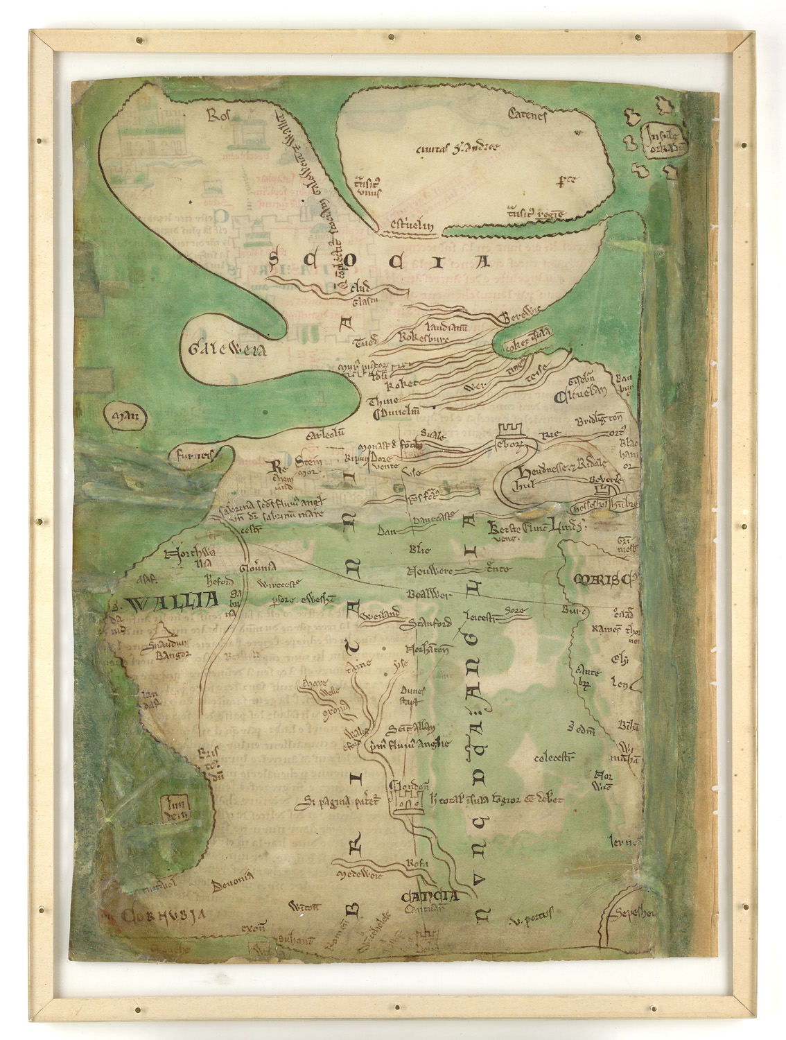
The itinerary does not stand alone in the manuscript. It is the second item in a short, deliberately assembled prefatory booklet of eight folios (ff. 1v-8r) that opens the volume: a diagram of the winds (f. 1v); this itinerary (ff. 2r-5r); Matthew Paris's own map of Britain, with a note of the great high road from Dover through London and St Albans to Durham (f. 5v); a tinted drawing of the Virgin and Child with the author, named in an inscription, kneeling in prayer at their feet (f. 6r); Easter tables running from 1116 to 1647 (f. 6v); and a calendar carrying the feast days specific to St Albans (ff. 7r-8r).
That sequence matters for reading the itinerary correctly. The map of Britain on f. 5v, drawn on the very next leaf, is a different object in a different genre: a regional map of an island, not a route. It is easy to conflate the two because they sit two pages apart in the same hand and the same campaign of work, and because Paris drew versions of both kinds of map repeatedly across his career. They are not the same picture and this record treats them as what the British Library's own catalogue treats them as: two separate items in one prefatory quire.
Which folios, and which versions
Matthew Paris drew the London-to-Jerusalem itinerary at least four times, and the copies are not identical. The simplest is a two-page spread in the Liber Additamentorum (British Library Cotton MS Nero D I, ff. 183v-184r). A fuller version, in French with the itinerary spread over three folios, prefaces a volume of the Chronica Majora at Corpus Christi College, Cambridge (Parker Library MS 26, ff. 1r-3r/4r), with a fragmentary fourth copy in the same library's MS 16. The version in this record, prefacing the Historia Anglorum in Royal MS 14 C VII, is the fullest of the group: five folios rather than three or two, with two additional pages given over specifically to the Holy Land, ending in a large plan-like rendering of Acre with Jerusalem, Mount Sinai and Bethlehem nearby.
Acre, not Jerusalem, dominates that final spread, drawn larger and given the more elaborate wall circuit. That is not an accident of composition. By the time Paris was drawing these maps, Jerusalem itself had been outside crusader control since the Khwarezmian sack of 1244, and Acre was the practical capital and principal port of what remained of the crusader states. A map meant to orient a reader toward the actual, currently reachable endpoint of a journey to the Holy Land would draw the functioning port larger than the symbolic but militarily unreachable city. The point is not stated by Paris; it is a reading argued from the map's own proportions and the political geography of the 1250s.
Matthew Paris, monk and chronicler
Matthew Paris entered St Albans Abbey as a Benedictine monk in 1217, probably in his teens, which is how his birth is conventionally placed around 1200. On the death of Roger of Wendover in 1236 he inherited Wendover's role as the abbey's chronicler and took over and continued Wendover's Flores Historiarum, reworking it into the basis of his own life's project, the Chronica Majora, a history of the world from Creation that he carried down to 1253 and continued, in a shorter version, to the year of his own death.
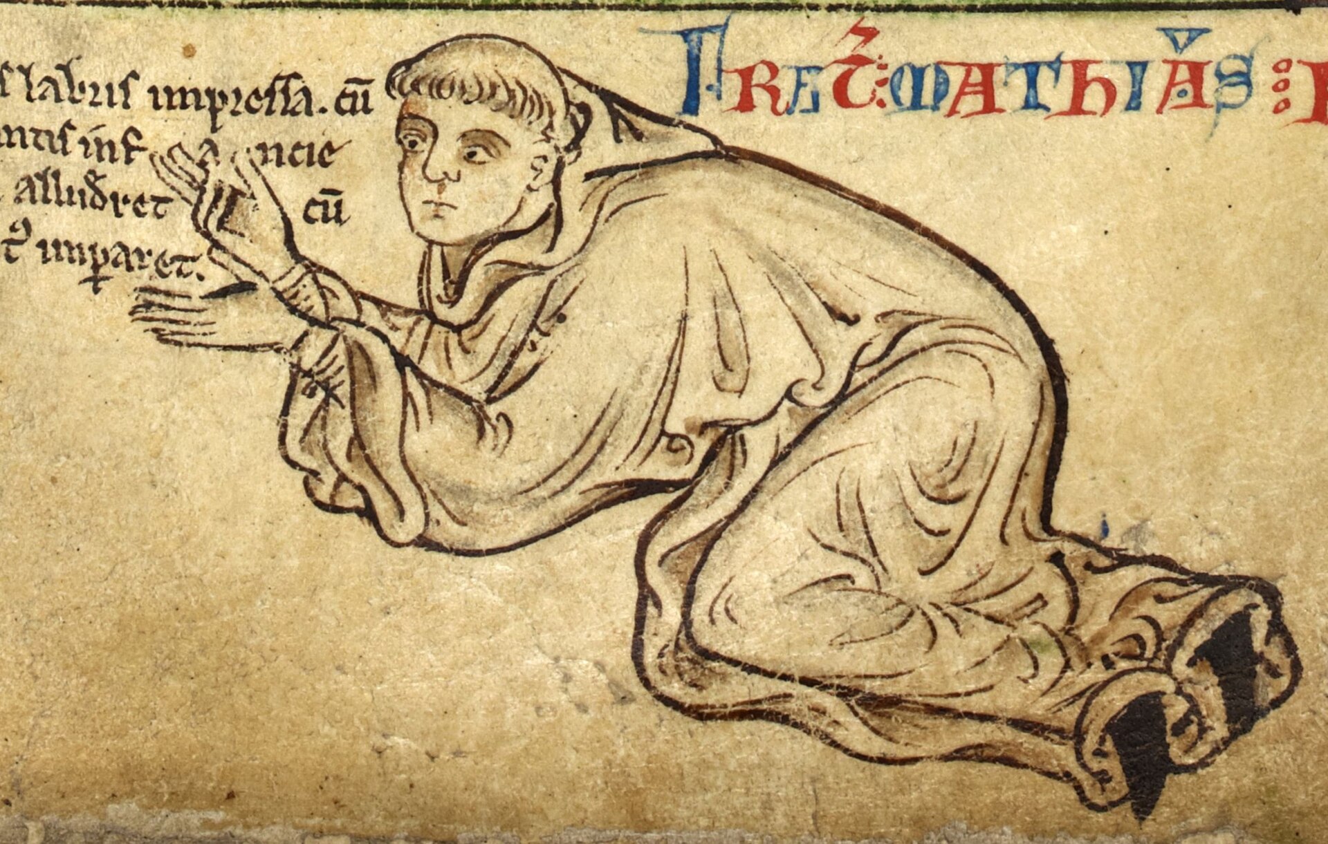
He was unusual among monastic chroniclers in being his own artist. Where most scriptoria divided the work of writing text from the work of painting images, Paris drew as well as wrote, working in a rapid pen-and-wash technique, tinted line drawing rather than fully modelled miniature painting, that let him illustrate his own histories at a pace and density no separate illuminator working to commission could easily have matched. The same prefatory quire that carries this itinerary carries, two leaves later, his own self-portrait: kneeling before the Virgin and Child, named by an inscription, at the foot of a full-page tinted drawing on f. 6r of this same manuscript.
Access to the world beyond the cloister
St Albans was not a remote house. It lay on the great north road, it was one of the wealthiest Benedictine abbeys in England, and its chronicler had a channel to information that most monks in most abbeys did not. Paris knew Henry III personally: in 1257 the king spent a week at St Albans and, in Paris's own account of the visit, kept him close and 'guided my pen with much goodwill and diligence,' anxious that his own reign be recorded accurately. In 1248 Paris himself carried a letter from Louis IX of France to King Haakon IV of Norway, inviting Haakon to join what would become Louis's crusade to Egypt, a mission that put a monk of St Albans personally in the diplomatic traffic of the Seventh Crusade rather than merely reporting on it after the fact.
That access explains why a monk who never went further than Norway on the king of France's business could draw, with any conviction, a route to a war he would never fight in. The itinerary is not the work of a man imagining a journey from nothing; it is the work of a chronicler who had handled the correspondence, met the returning knights, and had every reason to know which roads, which ports and which number of days between towns his readers would recognise as broadly right.
A map to be walked without leaving the cloister
The itinerary's design does more work than a practical road guide needs. Flaps of parchment were stitched to some of the pages in the sequence, hinged so a reader could lift them to reveal an alternative route or additional drawn detail, a device that forces the reader to handle the book rather than simply look at it. The sequence itself imposes a fixed order: bottom to top, left to right, one town at a time, in a rhythm closer to a devotional exercise than a itinerary a traveller would consult mid-journey.
Daniel Connolly has argued, first in a 1999 Art Bulletin article and at length in his 2009 monograph The Maps of Matthew Paris, that these maps functioned as instruments of imagined pilgrimage: a way for monks bound by vows of stability, who could not themselves travel to Jerusalem, to perform a devotional journey there in the mind, moving through the manuscript as a substitute for moving through the world. Dana Vasiliu has made a related case for the same seven opening pages as a deliberately constructed meditational tool bridging travel, history and liturgy. Neither claim rests on a statement by Paris himself explaining his intention; both are arguments from the map's physical design, made by named scholars in citable publications, and this record reports them as arguments, not as the chronicler's own stated purpose. What is documented, rather than argued, is the physical fact of the flaps and the fixed reading order; what the flaps and the order were FOR is Connolly's and Vasiliu's interpretation of that evidence.
Whose hand drew this copy
The standard attribution, following Richard Vaughan's paleographic study of Paris's manuscripts, treats Royal MS 14 C VII, prefatory quire included, as an autograph production of Matthew Paris and his St Albans scriptorium, and the British Library's own catalogue describes the volume as carrying two autograph copies of his historical works. Connolly's 2009 book disputes this for the itinerary specifically: he argues that the script, the spelling, and the added gold leaf decoration of this copy mark it out from Paris's other, plainer versions, and proposes instead that it is the work of a later, unidentified scribe, made for a royal patron, probably Edward I, rather than for a monastic reader at all. If Connolly is right, the map's intended audience shifts from a cloistered monk performing an imagined pilgrimage to a king with an active territorial interest in the routes to Scotland, Sicily and the Mediterranean, and its meaning shifts with it.
The two readings are not reconcilable by anything short of new codicological work, and this record does not adjudicate between them. It records the institutional attribution as the accepted one because that is what the holding library and the manuscript's principal cataloguer maintain, and it records Connolly's argument, by name, as the dissent.
How the manuscript reached the British Library
Nothing in the sources consulted documents where Royal MS 14 C VII was kept between its production at St Albans in the 1250s and its appearance in the English royal collection. St Albans Abbey was itself dissolved in 1539, and how the volume passed out of monastic hands and into royal ownership, whether directly at the Dissolution or by some later route, is not stated anywhere this record could verify. What is documented is the far end of that chain: the manuscript carries a Royal shelfmark, meaning it belonged to the Old Royal Library, the roughly 2,000-manuscript collection built up by successive English sovereigns from the reign of Edward IV onward, and in 1757 King George II gave that entire library to the recently founded British Museum. Royal MS 14 C VII passed to the Museum in that gift. When the British Library was established as an independent institution in 1973, separating the national library's holdings from the Museum's, the Royal manuscripts, this volume among them, transferred with it, and it has remained there since.
What is not settled
Several things a careful reader would want answered are not answered in the record as it currently stands, and are recorded here as findings rather than smoothed over. The manuscript's whereabouts for roughly three centuries between St Albans and the Old Royal Library are undocumented. The authorship of this specific copy, autograph Paris or a later royal scribe, is a live scholarly dispute rather than a settled fact. The map's original physical form before its leaves were separately mounted, whether it was ever a single continuous strip before being bound into a codex, is inferred rather than directly evidenced. And as catalogued by the British Library, full digital images of Royal MS 14 C VII are listed as currently unavailable through the library's own Digitised Manuscripts viewer, which limits how much of the itinerary beyond folio 2 can currently be checked online against the descriptions given here.
The artist
Matthew Paris (Latin: Mattheus Parisiensis)
Matthew Paris was a Benedictine monk of St Albans Abbey who was, unusually for his period, both the writer and the illustrator of his own historical works. He is the most prolific named cartographer of thirteenth-century England, and this itinerary is one of at least four surviving versions of a single journey he drew repeatedly across his career.
Related works
| Work | Relation | Where it is |
|---|---|---|
| Itinerary from London to the Holy Land (Chronica Majora copy) Matthew Paris | Sibling copy of the same itinerary, in a volume of the Chronica Majora Connolly reads this copy as the more monastic, spiritually oriented version, against the more secular Royal MS 14 C VII copy in this record. | Corpus Christi College, Cambridge, Parker Library MS 26, ff. 1r-3r |
| Itinerary from London to the Holy Land (fragment) Matthew Paris | Fourth, fragmentary surviving copy of the same itinerary The least complete of the four known versions. | Corpus Christi College, Cambridge, Parker Library MS 16 |
| Itinerary from London to the Holy Land (Liber Additamentorum copy) Matthew Paris | Simplest surviving copy of the same itinerary, a two-page spread The plainest of the four versions, without the extended Holy Land section found in Royal MS 14 C VII. | British Library, Cotton MS Nero D I, ff. 183v-184r |
| Map of Britain Matthew Paris | A different object in a different genre, drawn on the very next folio of the same bound volume as this itinerary Not the itinerary map. Shows the island's geography and the great road from Dover through London and St Albans to Durham, not a route to Jerusalem. Must not be pictured or described as the object of this record. | British Library, Royal MS 14 C VII, f. 5v |
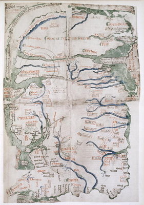
| Map of Britain Matthew Paris | A separate copy, in a different manuscript, of Paris's map-of-Britain genre Physically distinct from both this itinerary and the Royal MS 14 C VII Britain map. Included in the gallery only as a labelled comparison of Paris's other cartography. | British Library, Cotton MS Julius D VII, f. 49v |
| Map of Britain (the 'Claudius map') Matthew Paris | Paris's most celebrated map of Britain, in a further manuscript Regarded by scholars as the most detailed and ambitious of his surviving Britain maps; a different genre from the itinerary and not pictured in this record. | British Library, Cotton MS Claudius D VI |
| The Virgin and Child, with Matthew Paris in prayer Matthew Paris | Self-portrait, drawn two folios after this itinerary in the same prefatory quire The chronicler's own likeness, named by inscription, in the same campaign of work as the itinerary. | British Library, Royal MS 14 C VII, f. 6r |
Open questions
- Where was the manuscript kept between its production at St Albans in the 1250s and its appearance in the Old Royal Library? No specific owner or route is documented in the sources consulted, and St Albans Abbey itself was dissolved in 1539.
- Was this specific copy of the itinerary drawn by Matthew Paris himself, as the British Library's catalogue and the traditional Vaughan attribution hold, or by a later scribe working for a royal patron such as Edward I, as Daniel Connolly has argued from the script and decoration? The dispute is unresolved.
- Did the itinerary originate as a single continuous strip before being bound into the codex, as its 'now mounted separately' leaves suggest, and if so, when and why was it remounted in its current form?
- What did the stitched flaps mentioned in the secondary literature originally carry, and do any survive intact, or have some been lost since the leaves were remounted?
- Exactly when did Royal MS 14 C VII enter the Old Royal Library, and under which monarch? The sources consulted establish only that it was part of the collection by the time of George II's 1757 gift.
- What are the manuscript's or the individual leaves' physical dimensions in millimetres? No figure was found in the sources consulted for this record.
Questions about this object
What is Itinerary from London to the Holy Land?
Itinerary from London to the Holy Land is a map, dated c. 1250-1259. Medium: Pen and ink line drawing with tinted colour washes and gold leaf on parchment.
Who made Itinerary from London to the Holy Land, and is the attribution settled?
The attribution to Matthew Paris is recorded here as accepted. Attributed to Matthew Paris on the standard authority of the British Library's own catalogue, which describes Royal MS 14 C VII as carrying two autograph copies of his historical works with their prefatory material, and on the long-standing paleographic attribution made by Richard Vaughan in his 1958 study of Paris's hands. The attribution is not unanimous: Daniel Connolly, in his 2009 monograph on Paris's maps, argues from differences in script, spelling and the added gold decoration that this particular copy of the itinerary was made by a later, unidentified scribe, probably for a royal patron such as Edward I, rather than by Paris himself. This record follows the institutional and majority scholarly attribution while recording the dissent.
Where is Itinerary from London to the Holy Land now?
British Library, London, Royal MS 14 C VII, ff. 2r-5r (within the bound volume Royal MS 14 C VII). Last confirmed 14 September 2026. Part of the Old Royal Library, given to the British Museum by King George II in 1757; transferred to the British Library on its creation as an independent institution in 1973.
What is still unknown about Itinerary from London to the Holy Land?
Where was the manuscript kept between its production at St Albans in the 1250s and its appearance in the Old Royal Library? No specific owner or route is documented in the sources consulted, and St Albans Abbey itself was dissolved in 1539.
Sources
- 1British Library Archives and Manuscripts Catalogue, 'Royal MS 14 C VII, ff 1v-8r' (record 041-002338754): scope and content list for the prefatory quire, giving the exact folio range of the itinerary (ff. 2r-5r), the map of Britain (f. 5v), the self-portrait (f. 6r), and the manuscript's date range (c. 1250-1259). searcharchives.bl.uk/catalog/...
- 2British Library Archives and Manuscripts Catalogue, 'Royal MS 14 C VII' (record 040-002106988): scope, content and decoration description for the whole volume, including the itinerary's split into an Apulia leg (ff. 2r-4r) and a Holy Land leg (ff. 4v-5r), and the note that its leaves are now mounted separately. searcharchives.bl.uk/catalog/...
- 3British Library Archives and Manuscripts Catalogue, 'Royal MS 14 C VII, ff 8v-156v' (record 041-002338755): catalogue description of the Historia Anglorum text itself, confirming it as the only complete copy, probably composed and written 1250-1255. searcharchives.bl.uk/catalog/...
- 4British Library Archives and Manuscripts Catalogue, 'Royal MS 1 A I-20 E X: Royal Manuscripts' (record 032-002105724): top-level description of the Royal collection as manuscripts collected by English sovereigns from Edward IV onward. searcharchives.bl.uk/catalog/...
- 5Wikipedia, 'Royal manuscripts, British Library', for the formation of the Old Royal Library, George II's 1757 gift to the British Museum, and the 1973 transfer to the newly independent British Library. Tertiary source, flagged for replacement with the British Library's own published institutional history. en.wikipedia.org/wiki/...
- 6Wikipedia, 'Matthew Paris', for the biography, the 1257 Henry III visit and quotation, and the 1248 mission to Haakon IV of Norway. Tertiary source, flagged for replacement with Richard Vaughan's 'Matthew Paris' (Cambridge University Press, 1958) or a scholarly edition of the Chronica Majora. en.wikipedia.org/wiki/...
- 7Camille Serchuk, review of Daniel K. Connolly, 'The Maps of Matthew Paris: Medieval Journeys through Space, Time and Liturgy' (Boydell, Woodbridge, 2009), in The Medieval Review 10.06.39: the Vaughan attribution, Connolly's counter-argument for a later scribe and a royal patron (probably Edward I), and the imagined-pilgrimage thesis. scholarworks.iu.edu/journals/...
- 8Wikimedia Commons, File:Itinerary by Matthew Paris - Historia Anglorum (1250-1259), f.2 - BL Royal MS 14 C VII.jpg: file description, date (1250-1259), source (British Library via Flickr Commons, released March 2014), and licence (CC0 1.0 Universal Public Domain Dedication). commons.wikimedia.org/wiki/...
- 9Wikimedia Commons, File:Map of Britain (c.1250) - Matthew Paris, Historia Anglorum, f. 5v.jpg: file description confirming folio (f. 5v of Royal MS 14 C VII) and licence (Public Domain Mark 1.0). commons.wikimedia.org/wiki/...
- 10Wikimedia Commons, File:BritLibRoyal14CVIIFol006rMattParisSelfPort.jpg: file description confirming folio (f. 6r of Royal MS 14 C VII) and licence (Public Domain Mark / PD-Art). commons.wikimedia.org/wiki/...
- 11Wikimedia Commons, File:Map of Britain (c.1250) - Matthew Paris - STC255189.jpg: file description confirming this is a separate map, from British Library Cotton MS Julius D VII, f. 49v, distinct from Royal MS 14 C VII, with public domain licensing. commons.wikimedia.org/wiki/...
- 12Daniel K. Connolly, 'Imagined Pilgrimage in the Itinerary Maps of Matthew Paris,' The Art Bulletin 81, no. 4 (1999). Bibliographic citation only; full text and abstract were not accessible in this research session and the claims drawn from it here are cited via source 7 (the Medieval Review) and source 16, which discuss and quote the argument. tandfonline.com/doi/...
- 13Historia Cartarum, 'About Matthew Paris': overview of Paris's career as monk, chronicler and cartographer at St Albans, his royal connections, and his repeated production of itinerary and Britain maps across several manuscripts. historiacartarum.org/about-matthew-paris
- 14Medievalists.net, 'A Thirteenth-Century Meditational Tool: Matthew Paris's Itinerary Maps' (2011), summarising Dana Vasiliu's 2009 article in British and American Studies, vol. 15, on the itinerary as a meditational device for cloistered readers. medievalists.net/2011/...
- 15PeterRobins.co.uk, 'Medieval Itineraries: Matthew Paris': independent route-reconstruction resource giving the towns and day-counts along the itinerary and comparing the surviving manuscript versions. Not a peer-reviewed source; used here only for physical and route detail corroborated elsewhere, flagged for replacement with a scholarly edition. peterrobins.co.uk/itineraries/...
- 16The Pilgrim's Guide, 'Medieval (Re)interpretation of the Holy Places: Virtual Pilgrimage, Matthew Paris's Itinerary Map, and Meditative Tools': synthesis of the imagined-pilgrimage scholarship, including the stitched flaps and fixed reading order, citing Connolly. thepilgrimsguide.com/projects/...
,_f.2_-_BL_Royal_MS_14_C_VII.jpg)
_-_Matthew_Paris,_Historia_Anglorum,_f._5v.jpg)

_-_Matthew_Paris_-_STC255189.jpg)
Last verified 14 September 2026 · Published 14 September 2026
Change log
14 September 2026 - Record created at the house standard: researched narrative, technical evidence, maker dossier, graded provenance chain, prices with hammer and premium separated, related works, open questions and sources.