Carta marina navigatoria Portvgallen navigationes, atqve tocius cogniti orbis terre marisqve formam natvram sitvs et terminos nostris temporibvs recognitos et ab antiqvorum traditione differentes, eciam qvor vetvsti non meminervnt avtores, hec generaliter indicat
Martin Waldseemuller · 1516
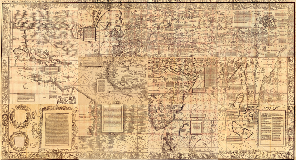
The Library of Congress composite of its sole surviving copy of the Carta Marina, Jay I. Kislak Collection, call number G1015 .S43 1517. This is the object described in this record, made in 1516, nine years after and physically separate from the 1507 world map that is the subject of a different record in this archive.
| Artist | Martin Waldseemuller |
|---|---|
| Date | 1516 |
| Medium | Woodcut with letterpress text on twelve sheets of laid paper, watermarked with a triple pointed crown, with extensive manuscript additions in ink and red ink by Johann Schoner |
| Dimensions | 128 x 233 cm assembled; sheets 46 x 63 cm or smaller (Library of Congress catalogue); Chet Van Duzer gives sheets as approximately 45.5 x 62 cm |
| Where it is now | Library of Congress, Geography and Map Division, Jay I. Kislak Collection, Washington DClast confirmed |
| Inventory number | G1015 .S43 1517 Vault (LCCN 2016586433) |
| Attribution | AcceptedAttributed to Martin Waldseemuller by the map's own title and by its place in the Schoner Sammelband alongside his signed 1507 map. Full note |
| Object type | Map |
| Period | German and Lorraine, early sixteenth century |
| Cases | Has a provenance gap |
| Inscriptions | Watermark of a triple pointed crown on all sheets. Ink annotations and a red-ink coordinate grid by Johann Schoner on every sheet except sheet 6. A paper patch over a shield on sheet 9 conceals a printed list of corrections. Sheet 6 is a proof impression, laid into the Sammelband after the volume was already bound. |
| Owners on record | 9 links8 documented, 1 unknown |
| Sources | 11 cited |
About this record Last verified · 11 sources cited · Change log
On this page 10 sections
ContentsClose
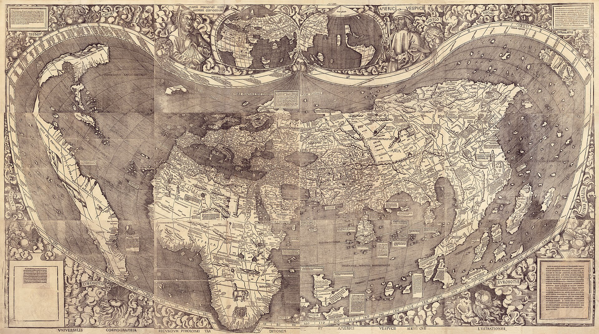
This is a different map from the Waldseemuller 1507 world map already in this archive. It is Martin Waldseemuller's second and last large wall map, printed nine years later in 1516, and it survives in exactly one copy, in the Jay I. Kislak Collection at the Library of Congress. The two maps were owned by the same man, the Nuremberg globemaker Johann Schoner, and bound into the same portfolio, the Schoner Sammelband, in 1517. They are not the same object and this record covers only the second one.
Where the 1507 map put Ptolemy and Amerigo Vespucci at the top of the sheet and coined the name America, the Carta Marina abandons both. It is built not on Ptolemy's geography but on a nautical chart, the Genoese pilot Nicolo de Caverio's chart of about 1503, and its list of the discoverers of the New World names Columbus first, Cabral second, and Vespucci third. The word America does not appear on it at all. Cuba is labelled part of Asia and the Pacific Ocean, which the 1507 map had shown before any European had seen it, is simply gone.
The Carta Marina did not arrive at the Library of Congress with the 1507 map. The Library bought only the 1507 sheets from the Waldburg-Wolfegg family in 2003. The Carta Marina, the companion globe gores, and the rest of the Sammelband portfolio passed instead through the collector Jay I. Kislak, who bought them and gave them to the Library in 2014, eleven years after the 1507 purchase and by an entirely separate transaction whose price is not published.
Provenance
Each link is graded. Documented: a cited source supports it. Disputed: the identification is argued but not established. Unknown: no owner for that span, and the gap is not smoothed into a narrative. The grades in the glossary.
- 1516 - by 1517Martin Waldseemuller, place of printing uncertain (catalogued as [Strasbourg, France?])documented
The printer is not named on the map. Physical evidence (a proof sheet, a concealed errata patch, and later copying by other cartographers) implies at least one other impression once existed, though none survives.25
- by 1517 - 1547Johann Schoner, Nurembergdocumented
Schoner used the map's coordinate grid to transfer data onto his own globes of 1515 and 1520. He died in 1547 per Van Duzer's monograph; a Library of Congress exhibition page gives 1474-1544 for Schoner, a discrepancy this record notes but does not resolve, parallel to a similar dating inconsistency already recorded for Waldseemuller himself on this archive's 1507 record.15
- 1547 - mid-seventeenth centuryNot establishedunknown
The same undocumented gap affects the 1507 map, since both objects were bound together in the same portfolio.
- mid-seventeenth century - twentieth centuryThe princely house of Waldburg-Wolfegg, Schloss Wolfegg, Upper Swabiadocumented
This record has not identified sources describing ownership stamps specific to the Carta Marina sheets, unlike the two Wolfegg stamps recorded on the verso of the 1507 map's upper left sheet.6
- 2003 - 2003Library of Congress (1507 map only)documented
This is the central fact distinguishing this object's provenance from the 1507 map's. The two did not arrive at the Library together.61011
- by 2014 - 2014Jay I. Kislak, member of the Library of Congress Madison Councildocumented
The Library's own press release states this plainly, but does not name the seller or the price. This record has found no source establishing either.6
- 2014 - 2015Library of Congress, Geography and Map Division, Jay I. Kislak Collectiondocumented
The two differing descriptions ('exchange' versus 'gift') for what appears to be one gift-and-transfer transaction are recorded here exactly as the Library's own catalogue states them.23
- late 2015 - presentLibrary of Congressdocumented
Price not published in the sources consulted.6
- 2016 - presentLibrary of Congressdocumented
Held in the Coolidge Auditorium, Thomas Jefferson Building, 6-7 October 2016.6
Prices realised
This object has never been offered at public auction. It has changed hands twice in the documented record: a private treaty purchase of the wider Schoner Sammelband portfolio (of which this map is part) by the collector Jay I. Kislak, on an unpublished date and for an unpublished price, followed by his gift and exchange of the map to the Library of Congress in 2014-2015. There is no hammer price, no buyer's premium, and no estimate for this object in any source consulted.
Technical evidence
| Attribution note | Attributed to Martin Waldseemuller by the map's own title and by its place in the Schoner Sammelband alongside his signed 1507 map. Authorship is not disputed. The printer is not identified and the place of printing is catalogued by the Library of Congress with a question mark: [Strasbourg, France?]. Careful study of the sheets shows multiple woodblock cutters working with little coordination, and there is no evidence Waldseemuller himself could cut a block; some scholars have wondered whether Albrecht Durer had a hand in the map's markedly superior artistry, but this remains unproven speculation, not an attribution. |
|---|---|
| Format | One map on twelve woodcut sheets, designed to be joined into a wall map. Overall 128 x 233 cm; sheets 46 x 63 cm or smaller per the Library of Congress catalogue, or approximately 45.5 x 62 cm per Van Duzer's independent measurement. Physically almost identical in size to Waldseemuller's 1507 map.12 |
| Cartographic model | Built on the model of a nautical or portolan chart rather than a Ptolemaic grid of latitude and longitude. The specific model chart has been identified as Nicolo de Caverio's nautical chart of Genoa, made around 1503 and now in the Bibliotheque nationale de France, on the evidence of matching place names and a closely similar layout of the rhumb-line network.1 |
| Geographic scope | Omits approximately 128 degrees of longitude present on the 1507 map and depicts less of the far north, reaching only a little past 70 degrees N rather than the pole. Does not depict the Pacific Ocean at all, and shows a much reduced South American landmass.145 |
| Imprint | Catalogued by the Library of Congress as [Strasbourg, France?]: publisher not identified, [1516]. No printer's name appears on the map.2 |
| Paper and watermark | All sheets bear a watermark of a triple pointed crown, the same watermark recorded on the 1507 map, which is part of the physical evidence used in dating disputes over both maps.2 |
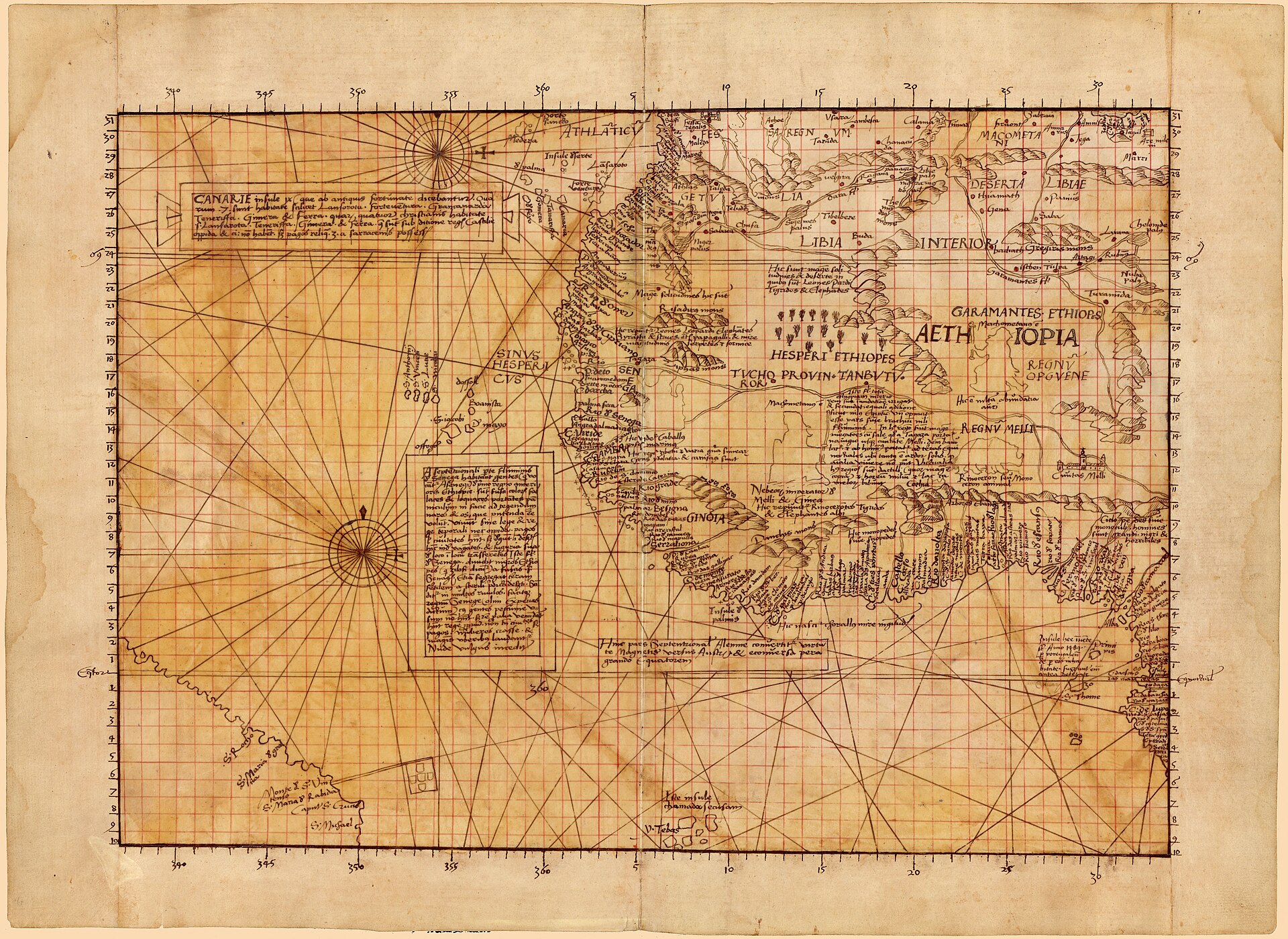
| Manuscript additions | All sheets except sheet 6 carry ink annotations and a red-ink coordinate grid added by Johann Schoner across the entire map, made so that Schoner could transfer place data onto his own globes.25 |
| Sheet 6, proof state | Sheet 6 of the Library's copy is a proof impression that was laid into the Schoner Sammelband only after the volume had already been bound, rather than at the same time as the other eleven sheets. A separate manuscript copy of sheet 6, apparently made by or for Schoner, survives as its own catalogued item.23 |
| Sheet 9, concealed errata | A small paper patch is pasted over a shield in the map's border on sheet 9. Conservation examination found that the patch conceals a printed list of corrections to the map that had already been made by the time this copy was assembled, indicating at least one earlier, uncorrected state existed.25 |
| Production evidence | Multiple woodblock cutters worked on the map with inconsistent styles and little coordination: wind-heads, cloud rendering, and compass rose designs vary between adjoining sheets, the decorative cartouche on sheet 9 is cut off by the sheet's edge, and rivers and mountain ranges are sometimes discontinuous across sheet joins.1 |
| Call number | G1015 .S43 1517 Vault, Geography and Map Division, Library of Congress, Jay I. Kislak Collection. LCCN 2016586433.2 |
Images
The record in full
Chapter 1A second wall map, not a sequel
Martin Waldseemuller printed two large wall maps in his working life.
Martin Waldseemuller printed two large wall maps in his working life. This record is about the second, made in 1516, nine years after the map that first put the name America on paper. The two objects are physically similar: both are printed from twelve woodcut sheets designed to be joined into a wall map of about 128 by 233 centimetres, and both survive in exactly one copy, owned by the same man and bound into the same portfolio. But they are different maps, made from different sources, showing a different and in some ways smaller world, and they are catalogued, housed, and were acquired by the Library of Congress separately. Nothing in this record should be read as describing the 1507 map, which already has its own entry in this archive.
The Library of Congress's own comparison is blunt about what changed: this map is markedly superior to the 1507 map in artistic detail, incorporates greatly expanded and corrected geographical information, and could be considered the first printed nautical map of the entire world. It is also, on the question that made its predecessor famous, a retreat.
Chapter 2Built on a chart, not on Ptolemy
The 1507 map is a Ptolemaic world map with the New World added: it uses a grid of latitude and longitude and follows the projection of a large map by Henricus Martellus.
The 1507 map is a Ptolemaic world map with the New World added: it uses a grid of latitude and longitude and follows the projection of a large map by Henricus Martellus. The Carta Marina throws that model out. Its full title announces the change: a nautical chart comprehensively showing the Portuguese voyages and the shape of the whole known world as determined in modern times, differing from the tradition of the ancients. Where the 1507 map's title credited both Ptolemy and Vespucci, the 1516 title credits neither.
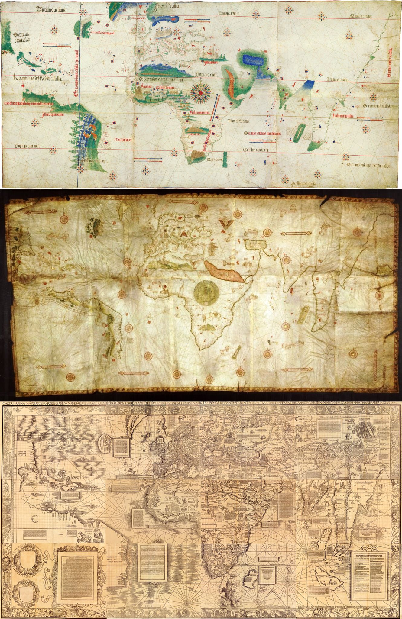
Chet Van Duzer, whose 2020 study is the first detailed examination of the map's texts and images, has identified the specific chart Waldseemuller used as his model: a nautical chart by the Genoese pilot Nicolo de Caverio, made around 1503 and now in the Bibliotheque nationale de France. The place names and the layout of the rhumb-line network on the Carta Marina match Caverio's chart closely enough to be certain of the connection. What makes this puzzling rather than simply a change of taste is that Waldseemuller already had access to the Caverio chart when he made the 1507 map, and chose the Ptolemaic system anyway. Something changed his mind in the years between, very possibly while he was working on a new edition of Ptolemy's Geography in 1513, whose modern maps are themselves built on nautical-chart data rather than Ptolemy's grid.
Chapter 3The word that is missing
The 1507 map put Vespucci's portrait at the top of the sheet and applied his first name to the newly found continent.
The 1507 map put Vespucci's portrait at the top of the sheet and applied his first name to the newly found continent. The Carta Marina does neither. Its long introductory text, in the lower left corner, lists Waldseemuller's sources by name, and Vespucci is not among them, though Columbus is. Elsewhere on the map a legend in the southern Atlantic ranks the discoverers of the New World in order: Columbus first, Cabral second, Vespucci third. The word America does not appear on the Carta Marina at all.
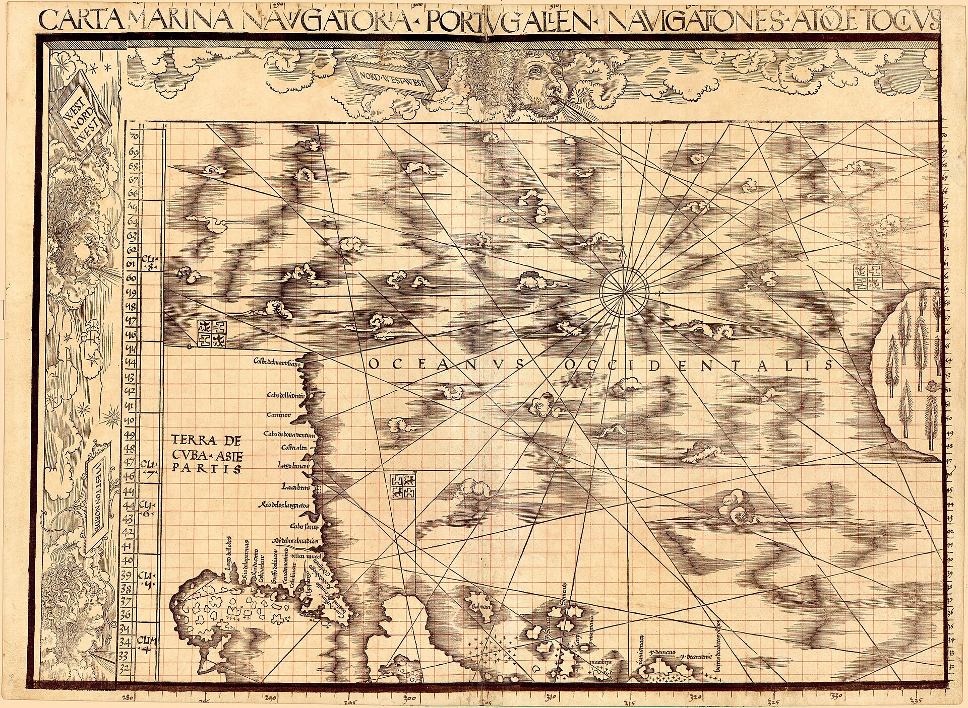
Nor is this a matter of a missing label alone. Waldseemuller adopts what Van Duzer calls a Columbian conception of the new lands. A legend on the northern landmass reads TERRA DE CVBA - ASIE PARTIS, the land of Cuba, part of Asia: exactly the belief Columbus held to his death, that he had reached the eastern edge of Asia by sailing west. A legend on Hispaniola identifies the island as Ophir, the biblical source of King Solomon's gold, which is also a claim Columbus made in his own writing. In other words the Carta Marina does not merely drop a name. It replaces Vespucci's reading of the New World as a separate continent with Columbus's belief that it was Asia, a belief that was wrong, and that Waldseemuller's own 1507 map had in one sense already corrected.
Chapter 4Why he changed his mind is not settled
This is a genuine and still-open question in the scholarship, not a puzzle this record can resolve.
This is a genuine and still-open question in the scholarship, not a puzzle this record can resolve. Van Duzer's own reading is that Waldseemuller had by 1516 concluded, probably from Columbus's own account of his 1492 voyage as printed in the Paesi novamente retrovati, that Columbus rather than Vespucci had priority as discoverer, and that the cartographer changed his map because he had changed his mind about the facts. Van Duzer is explicit that he does not read this as a response to customer demand: in his words, it was not the demands of customers, but rather his own determination to find the best method for representing the world, that led Waldseemuller to start again from scratch. On this reading the two figureheads of the 1507 map, Ptolemy and Vespucci, fell away together because Waldseemuller's thinking about both geography and discovery had moved on.
John Hessler, who curated the Library's Kislak Collection and co-authored an earlier study of both maps with Van Duzer, has taken a more cautious line in print, presenting several possible explanations for Waldseemuller's changes of mind rather than settling on one, on the grounds that it is impossible to walk in Waldseemuller and Ringmann's shoes five hundred years later. At the Library of Congress's own 2016 conference marking the map's five-hundredth anniversary, the cartographic historian Don McGuirk spoke specifically on the topic of Columbus, Vespucci, and the Carta Marina, alongside Van Duzer's own paper on the map's originality and diffusion; this record has not been able to read McGuirk's argument directly; only the fact that he addressed the question. No consensus explanation has been published, and this record treats the question as open rather than choosing between the available readings.
A further complication is that the map may never have been a commercial object at all. The cartographic historian Hildegard Binder Johnson argued that the Carta Marina was never published or sold, and that the sole surviving copy is not a market exemplar but a special proof printing. Van Duzer notes that no scholar has presented evidence against this. If Johnson is right, the map's conservatism cannot simply be read as a bid for a different, more commercially minded audience than the 1507 map's wall-map buyers, since on this reading it may never have reached a buyer of any kind.
Chapter 5The vanishing Pacific
The Carta Marina omits about 128 degrees of longitude that the 1507 map included, and it depicts less of the far north, running only to a little over 70 degrees north where the earlier map reached...
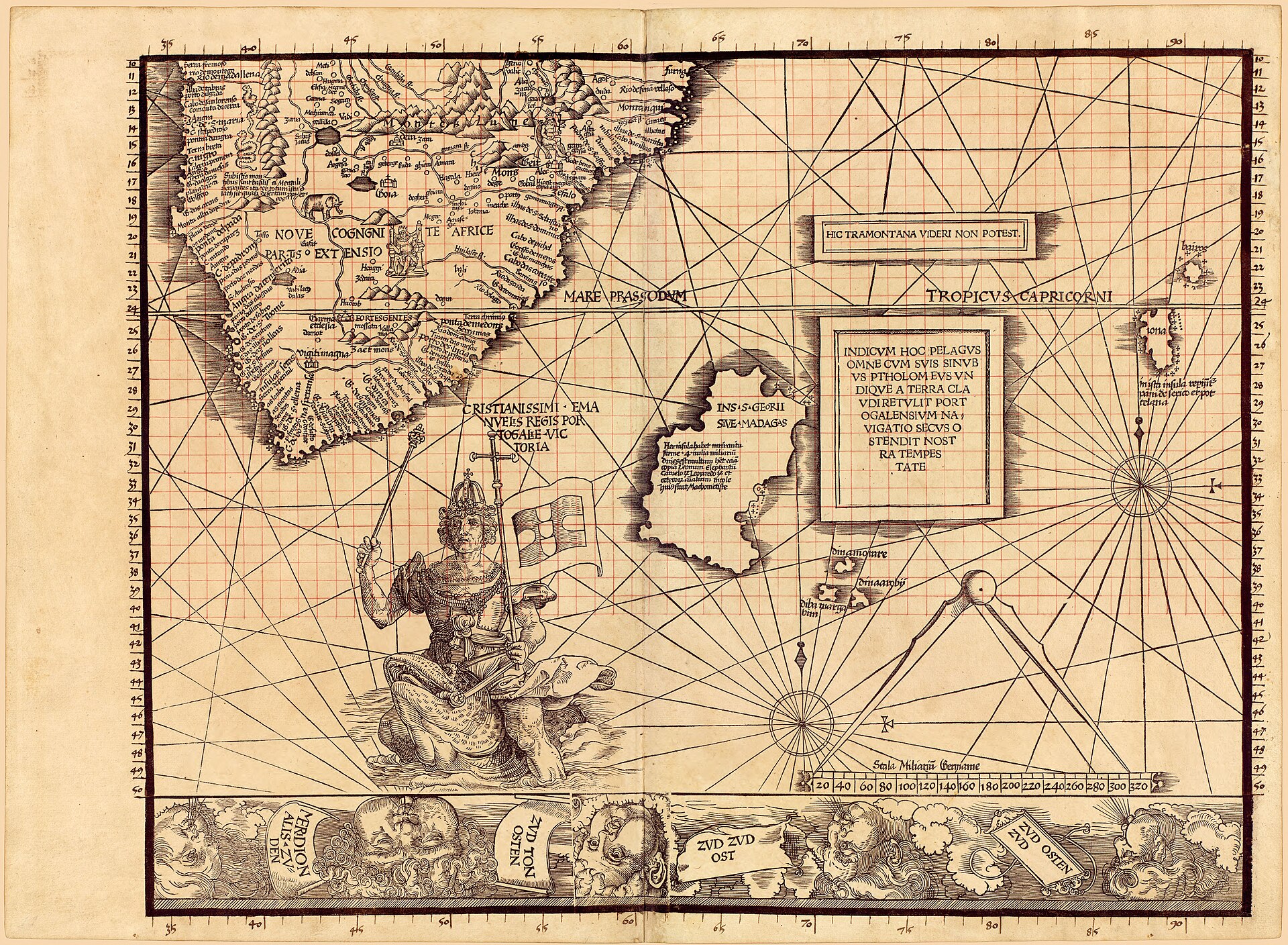
The Carta Marina omits about 128 degrees of longitude that the 1507 map included, and it depicts less of the far north, running only to a little over 70 degrees north where the earlier map reached the pole. Most strikingly, the Library of Congress states plainly that the 1516 map, unlike the 1507 map, does not show the existence of the Pacific Ocean at all, and shows a greatly reduced continent of South America whose outline resembles the Cantino planisphere rather than anything more expansive.
This is not a failure of information. Waldseemuller had good data on the distance from mainland Asia to Japan, drawn from Marco Polo, and had used it on the 1507 map to justify a separate ocean between Asia and the New World. He simply chose not to use it here. Van Duzer's reading is that the Carta Marina was designed to be more practical than the 1507 map: it shows only the parts of the world where Europeans had actually travelled and where trade was known to occur, in the fundamentally practical format of a nautical chart, rather than the whole circumference of the earth. Because the sheets are the same overall size as the 1507 map's but cover a smaller area, the effect is a zoomed-in view of the known world, with far more text and illustration per region than the earlier map could carry. Arabia, which on the 1507 map has room only for Ptolemaic place names, gets images of Mecca and Medina and long descriptive legends on the Carta Marina.
Chapter 6A king riding a sea monster
The 1507 map's Indian Ocean is crowded with dangerous sea monsters, copied from the encyclopedia Hortus sanitatis by way of Henricus Martellus's map.
The 1507 map's Indian Ocean is crowded with dangerous sea monsters, copied from the encyclopedia Hortus sanitatis by way of Henricus Martellus's map. On the Carta Marina those monsters are gone, replaced by a single, deliberate image: south of the Cape of Good Hope, King Manuel of Portugal rides a sea monster through the waves, holding aloft a sceptre and the banner of Portugal.
Van Duzer traces the likely source of this image to Jacopo de' Barbari's monumental view of Venice of about 1500, which shows Neptune riding a sea monster in the lagoon in front of St Mark's Square, with an inscribed sign reading, in translation, I, Neptune, reside here, watching over the seas at this port. Waldseemuller's image replaces the classical god with a living king, which Van Duzer reads as an argued case, not a certainty, as something close to an apotheosis of Manuel, and changes the meaning from Venice's passive protection to Portugal's active control of the sea route to India after Vasco da Gama. The image alludes directly to the title Manuel adopted after da Gama's return, Lord of the conquest, and navigation, and commerce of Ethiopia, Arabia, Persia and India, a title reported in the same travel compilation, the Paesi novamente retrovati, that supplied much of the map's other current information. Van Duzer's own summary of the change is worth recording exactly: most of the sea monsters on the 1507 map are dangerous and would discourage navigation, while the image of a king riding a sea monster on the Carta Marina boldly proclaims human control over the dangers of the sea, and by extension dominion over the oceans themselves.
Chapter 7The Great Khan and the monstrous races of India
In the northeastern corner of the map, on the sheet covering northeastern Asia, is a large and finely executed image of the Great Khan seated in his tent, rendered at a scale matched on the whole map...
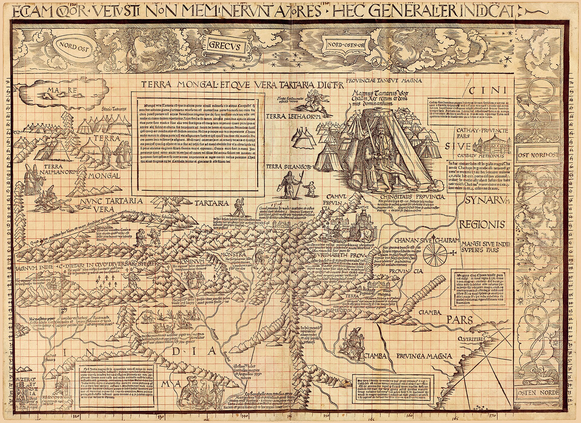
In the northeastern corner of the map, on the sheet covering northeastern Asia, is a large and finely executed image of the Great Khan seated in his tent, rendered at a scale matched on the whole map only by King Manuel's image. Waldseemuller had said almost nothing about the Khan in either the 1507 map or its accompanying booklet; the Carta Marina gives him one of its two largest figures, which Van Duzer connects to the map's new emphasis on practical political information, since the Khan represented a real and current threat to Europe.
On the same sheet, in northern India, Waldseemuller depicts several of the monstrous races of medieval travel literature together for the first time on any known map: men with the heads of dogs, Cyclopes, men whose faces are set in their chests, and pygmies, drawn from the medieval travellers John of Plano Carpini and Pierre d'Ailly. The material is old, reaching back through Plano Carpini and d'Ailly to a much older European idea of India as a land of marvels; what is new is Waldseemuller's decision to collect several of these figures on one map. Nearby, on the same sheet, is an image of sati, a widow burning herself to death on her husband's funeral pyre, copied closely from a 1515 German woodcut illustrating the traveller Lodovico de Varthema's account of the practice at Tarnassari, made just one year before the Carta Marina itself.
Chapter 8Borrowed bodies: how the map's illustrations travelled
Waldseemuller's iconographic programme on the Carta Marina is assembled almost entirely from recent printed sources, and tracing them shows both real curiosity about the wider world and a working...
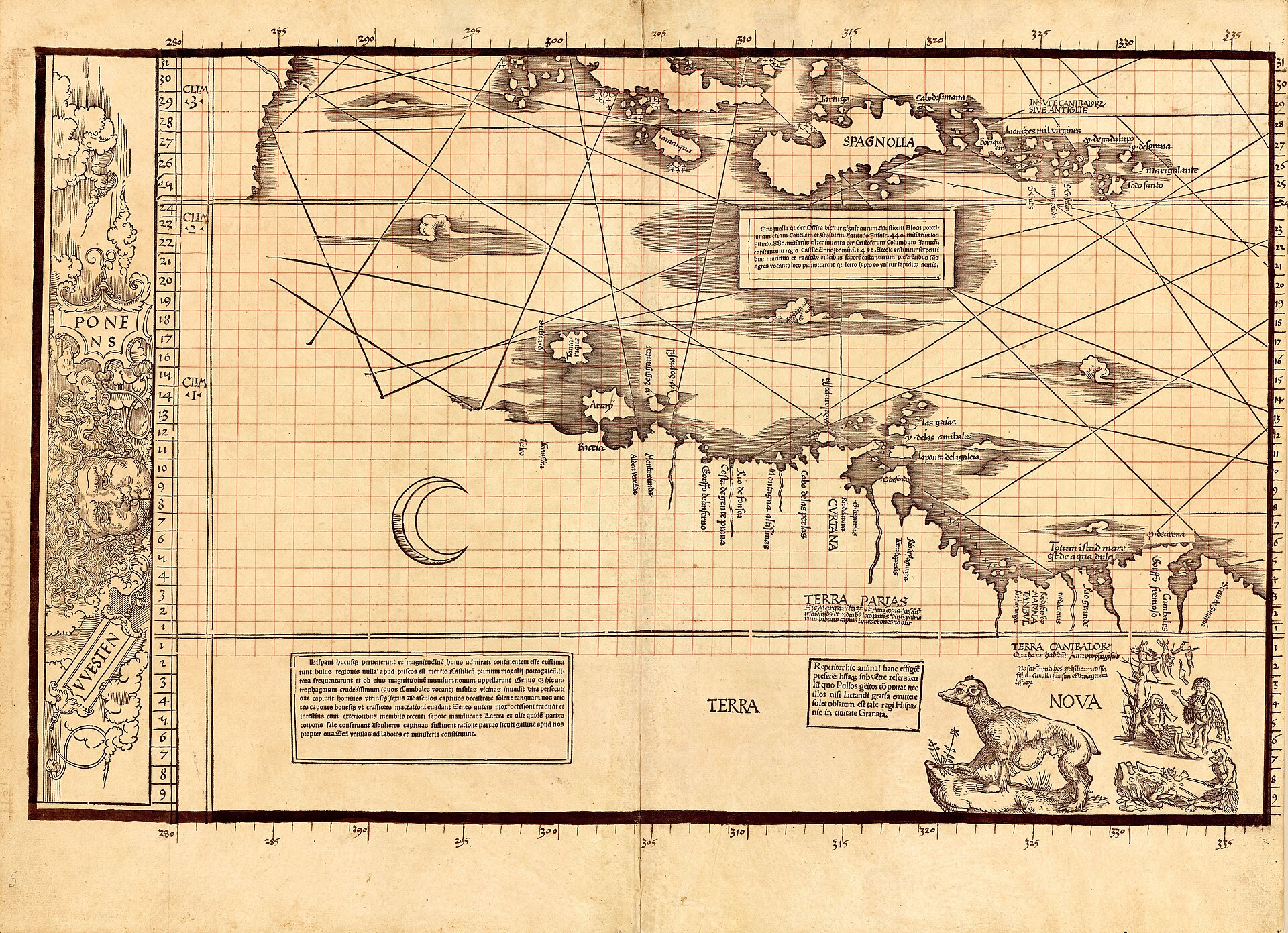
Waldseemuller's iconographic programme on the Carta Marina is assembled almost entirely from recent printed sources, and tracing them shows both real curiosity about the wider world and a working method under time pressure. In South America the map carries the earliest surviving European depiction of an opossum, an animal first seen by a European when Vicente Yanez Pinzon encountered one in 1499 and brought a specimen back to Spain; an early description calls it a strange monster with the foreparts of a fox, the hindparts of a monkey, and a great bag under its belly for carrying its young. In Scandinavia the map shows a walrus rendered as an elephant-like creature with tusks, described in the accompanying legend as huge, the size of an elephant, found in herds of two hundred in the northern promontories of Norway; the image was made from a written description rather than direct observation, though the herding behaviour recorded in the text may come from a genuine, if secondhand, account.
Other images were reused across continents. Waldseemuller took an image of an Indian man from a 1509 illustrated account of Francisco de Almeida's voyage to India, illustrated by Hans Burgkmair, and used it twice: once, lightly altered, to depict a king in southwestern India, and once again, in a different pose borrowed from another illustration in the same book, to depict a king in Senegal, in West Africa. He used a 1515 image of Medina from an illustrated edition of Varthema's travels to depict Mecca instead, replacing the flames the original showed issuing from the building's roof with an Islamic crescent. And the flag flown over Calicut carries an image of a black devil, based on Varthema's account of what he took to be devil-worship there, an account now understood as a European misreading of Hindu religious imagery rather than an accurate report. A small image of a rhinoceros in West Africa was copied not from Albrecht Durer's famous 1515 print of the animal, which had recently been presented to King Manuel, but from a rival print of the same rhinoceros made the same year by Hans Burgkmair, which survives today in only one copy.
Chapter 9A chaotic printing
Close examination of the surviving sheets shows that several different block cutters worked on the Carta Marina with little coordination between them.
Close examination of the surviving sheets shows that several different block cutters worked on the Carta Marina with little coordination between them. The wind-heads decorating the map's margins are rendered in inconsistent styles from sheet to sheet; the compass roses at the nodes of the rhumb-line network vary in size and spacing; clouds and open water are drawn differently on adjoining sheets; and on sheet 9 the decorative border is cut off awkwardly by the edge of the sheet, in a way none of the other eleven sheets shows. Rivers and mountain ranges sometimes fail to line up across the join between two sheets.
Van Duzer weighs several explanations, hasty work, production drawn out over time by lack of funds, sheets cut at different times by different hands, without settling on one; a note of thanks on the map to Hugues des Hazards, Bishop of Toul, presumably for financial support, may point to funding difficulties that were later resolved rather than to a smoothly run project. Physical evidence backs this up directly. Sheet 6 of the Library of Congress's copy is a proof impression, laid into the Sammelband only after the volume was already bound, meaning at least one other pull of that sheet must once have existed. And on sheet 9 a small paper patch covers a shield in the map's border; when the patch was examined during conservation, it was found to conceal a printed list of corrections to the map, the errata that had already been fixed by the time the Library's copy was finished. Both facts point to more than one impression of at least some sheets having existed, which sits uneasily with Hildegard Binder Johnson's argument, noted above, that the map was never actually sold.
Chapter 10One copy, two archives, eleven years apart
The Carta Marina and the 1507 map share almost their entire physical history.
The Carta Marina and the 1507 map share almost their entire physical history. Both were owned by Johann Schoner, the Nuremberg astronomer, mathematician, and globemaker, who bound them together in 1517 into the portfolio now called the Schoner Sammelband, along with a set of his own globe gores and, from 1515, Albrecht Durer's printed star chart. Schoner drew a coordinate grid in red ink over the entire Carta Marina, and over parts of the 1507 map, in order to transfer place names and coordinates onto his own globes; his 1515 printed globe drew heavily on the 1507 map, and his largely unstudied manuscript globe of 1520 borrows a number of legends from the Carta Marina. He also made, or had made, a careful manuscript copy of sheet 6 of the Carta Marina, now catalogued at the Library of Congress as its own item. The Sammelband passed at some point, undocumented in the sources consulted here, into the collections of the Waldburg-Wolfegg family at Schloss Wolfegg in Upper Swabia, where the whole portfolio lay together until the twentieth century.
Here the two maps' histories diverge, and this is the point at which confusing them becomes easy and wrong. In 2003 the Library of Congress completed its purchase, agreed with Prince Johannes Waldburg-Wolfegg, of the 1507 map alone, for USD 10 million. The Carta Marina, the globe gores, and the rest of the Sammelband portfolio were not part of that transaction and did not come to Washington in 2003. They remained in a different ownership track for another eleven years. Jay I. Kislak, a member of the Library's Madison Council and a major benefactor of its collection on the early Americas, purchased the Carta Marina, the globe gores, and the Sammelband portfolio itself, from a seller and for a price this record has not been able to establish, and donated them to the Library of Congress in 2014. The Library's own catalogue record for the Carta Marina describes the transfer as acquired on exchange from the Jay I. Kislak Foundation, while its catalogue record for the companion manuscript copy of sheet 6 describes the same transaction as a gift from the same foundation; both carry the same acquisition control number, 2015-052, suggesting the paperwork was processed the following year. The Library completed the reassembly of the original Sammelband in late 2015, when it separately purchased Durer's 1515 star chart, the fourth component, from another source.
The consequence is that the Carta Marina and the 1507 map, inseparable for roughly four hundred years inside one bound volume, arrived at the Library of Congress eleven years apart, through two different transactions, from two different immediate sources, for two different and largely unpublished sums of money. Anyone assuming the 2003 purchase brought both maps to Washington is simply wrong about this object's history.
Chapter 11Five hundred years on
In October 2016 the Library of Congress marked the map's five-hundredth anniversary with a two-day conference, Facts or Fictions, sponsored by the Jay I.
In October 2016 the Library of Congress marked the map's five-hundredth anniversary with a two-day conference, Facts or Fictions, sponsored by the Jay I. Kislak Family Foundation and the Gray Family Memorial Fund, which brought together historians of cartography, science, and literature to discuss the Carta Marina alongside other contested maps of the period, including the Vinland Map. The Library and the Galileo Museum in Florence jointly launched a multimedia website on Waldseemuller's life and cartography at the same event, and the Library's Conservation Division presented on the preservation and encasement of the 1507 map. The conference doubled as a formal close to the Sammelband reassembly project: by 2016 all four of the original portfolio's components, the two wall maps, Schoner's globe gores, and Durer's star chart, were finally reunited in one division of one library, for the first time since the sixteenth century.
Chapter 12What later mapmakers took from it
Because only one exemplar of the Carta Marina survives, its influence has to be traced indirectly, and the evidence is good.
Because only one exemplar of the Carta Marina survives, its influence has to be traced indirectly, and the evidence is good. In 1525 the cartographer Lorenz Fries and the publisher Johann Gruninger issued a reduced-scale version of the map at Strasbourg, with a German booklet, Uslegung der mercarthen oder Charta marina, supplying descriptions that would not fit on the sheet itself; no copy of the 1525 printing survives, but single exemplars of Fries's 1530 and 1531 re-editions do, and comparison of their images with Waldseemuller's confirms that Fries, or whoever supplied his workshop with a model, worked from a now-lost exemplar of the Carta Marina distinct from the one Schoner kept.
Stronger evidence comes from the Vallard Atlas, a manuscript atlas of nautical charts made around 1547 by the Dieppe school of French cartographers and now in the Huntington Library. Its image of the King of France riding a sea monster south of Africa is copied from Fries's version of Waldseemuller's image rather than from Waldseemuller's original; but its image of Mecca is strikingly close to Waldseemuller's own version, not to the simpler image on Fries's map, meaning the Dieppe workshop must have had independent access to a copy of the Carta Marina itself. In 1570 Abraham Ortelius listed a Martin Ilacomilus of Freiburg, a map of Europe, and separately a Martinus Waldseemuller universal nautical chart, commonly called Marina, published in Germany, adding that he believed the two names referred to the same cartographer; this is the clearest documentary proof that the Carta Marina circulated widely enough to reach a major Antwerp mapmaker two generations later. Claims that Gerard Mercator drew directly on the Carta Marina for his own 1569 world map are harder to sustain, since the one clear correspondence identified so far, in the legend describing the opossum, could equally have come from Mercator's own copy of Fries's edition.
The artist
Martin Waldseemuller
This archive already carries a dossier on Waldseemuller's career up to and including his famous 1507 map. The facts below focus instead on what changed in his final decade of work, on the Carta Marina specifically, and on Johann Schoner, the man whose ownership and annotation are the reason either of Waldseemuller's wall maps survives at all.
Related works
| Work | Relation | Where it is |
|---|---|---|
| Universalis Cosmographia (the 1507 world map) Martin Waldseemuller | The same cartographer's earlier and more famous wall map, made nine years before the Carta Marina and already covered by its own record in this archive. The two maps share an owner (Johann Schoner) and a single bound history in the Schoner Sammelband, but are physically separate objects with separate acquisition histories at the Library of Congress. Do not confuse the two records. This record covers only the 1516 Carta Marina. | Library of Congress, Geography and Map Division, Washington DC |
| Nautical chart of the world Nicolo de Caverio | The specific manuscript chart, made around 1503, that Waldseemuller used as his direct model for the Carta Marina's coastlines and rhumb-line layout Similar in size to Waldseemuller's own maps at 115 x 225 cm. | Bibliotheque nationale de France, Cartes et plans, SH archives 1 |
| Orbis Typus Universalis Iuxta Hydrographorum Traditionem (the 'Admiral's Map') Martin Waldseemuller | The modern world map in Waldseemuller's own 1513 edition of Ptolemy's Geography, a transitional work between the 1507 and 1516 maps that already uses a nautical-chart projection with rhumb lines rather than a Ptolemaic grid The nickname 'Admiral's Map' is misleading: Waldseemuller's own text credits an unnamed former admiral of Portugal's surveys, not Columbus specifically, and the map draws on multiple explorers. | Library of Congress, Rare Book and Special Collections Division |
| Globe gores of 1507 Martin Waldseemuller | Companion object from the same Schoner Sammelband, part of the Kislak gift rather than the 2003 purchase Two of the roughly six known copies of this globe gore set are now established or strongly suspected twentieth-century forgeries, a fact recorded on this archive's 1507 record. | Several collections; one set in the Jay I. Kislak Collection, Library of Congress |
| Star chart of the southern hemisphere, 1515 Albrecht Durer | The fourth original component of the Schoner Sammelband, purchased separately by the Library of Congress in late 2015 to complete the portfolio's reassembly Bought a year after the Carta Marina and globe gores arrived via the Kislak gift. | Geography and Map Division, Library of Congress |
| Carta marina Lorenz Fries, after Martin Waldseemuller | Reduced-scale re-editions of the Carta Marina, published 1525 (no copy survives), 1530, and 1531, with an accompanying German-language booklet The clearest surviving evidence that a version of Waldseemuller's map circulated and was copied beyond Johann Schoner's own exemplar. | Bayerische Staatsbibliothek, Munich (1530); Museum zu Allerheiligen, Schaffhausen (1531) |
| Vallard Atlas Anonymous, Dieppe school of cartography | A manuscript atlas of nautical charts, made around 1547, whose image of Mecca is close enough to Waldseemuller's own version (rather than Fries's simplified copy) to prove its maker had independent access to the Carta Marina itself Its King of France riding a sea monster is copied from Fries, not from Waldseemuller directly, showing the atlas drew on both sources. | Huntington Library, San Marino, California, MS HM 29 |
Open questions
- Why did Waldseemuller abandon Vespucci for Columbus and drop the name America between 1507 and 1516? Van Duzer argues it reflects a genuine change of mind about who deserved credit as discoverer; Hessler has declined to settle on a single explanation; no consensus has been published, and this record does not choose between the available readings.
- Was the Carta Marina ever actually sold as a printed map, or is the sole surviving copy a proof that never reached a buyer? Hildegard Binder Johnson has argued for the latter, and Van Duzer notes no scholar has presented evidence against her; but the existence of a corrected errata state, a laid-in proof sheet, and clear later copying by Lorenz Fries and the Dieppe school implies more than one impression once existed.
- Why was the map's printing so uncoordinated among the block cutters, with mismatched styles, a misaligned cartouche on sheet 9, and discontinuous rivers between sheets? Funding trouble, haste, and division of labour by geography have all been suggested; Van Duzer states plainly that it is not possible to know without further evidence.
- How did the Carta Marina, the globe gores, and the rest of the Sammelband portfolio pass from the Waldburg-Wolfegg family to Jay I. Kislak before 2014? Unlike the well-documented 1999-2003 licence and purchase trail for the 1507 map, no source consulted for this record identifies the seller, the date, or the intermediate history of this transaction.
- What did Jay I. Kislak pay for the Carta Marina, the globe gores, and the Sammelband portfolio in 2014, and what did the Library of Congress pay for the Durer star chart in 2015? Neither figure is published in the sources consulted.
- Was Albrecht Durer personally involved in engraving or designing any of the Carta Marina's images, as the map's markedly superior artistic quality has led some to suggest? No direct evidence has been presented, and Van Duzer treats this as unproven speculation rather than an attribution.
- Does the surviving manuscript copy of sheet 6, apparently made by or for Johann Schoner, imply that a second full printed exemplar of the Carta Marina once existed from which it could have been copied, or is it simply a study copy made for Schoner's own globe-making reference? The sources consulted for this record do not resolve the question.
Questions about this object
What is Carta marina navigatoria Portvgallen navigationes, atqve tocius cogniti orbis terre marisqve formam natvram sitvs et terminos nostris temporibvs recognitos et ab antiqvorum traditione differentes, eciam qvor vetvsti non meminervnt avtores, hec generaliter indicat?
Carta marina navigatoria Portvgallen navigationes, atqve tocius cogniti orbis terre marisqve formam natvram sitvs et terminos nostris temporibvs recognitos et ab antiqvorum traditione differentes, eciam qvor vetvsti non meminervnt avtores, hec generaliter indicat is a map, dated 1516. Medium: Woodcut with letterpress text on twelve sheets of laid paper, watermarked with a triple pointed crown, with extensive manuscript additions in ink and red ink by Johann Schoner.
Who made Carta marina navigatoria Portvgallen navigationes, atqve tocius cogniti orbis terre marisqve formam natvram sitvs et terminos nostris temporibvs recognitos et ab antiqvorum traditione differentes, eciam qvor vetvsti non meminervnt avtores, hec generaliter indicat, and is the attribution settled?
The attribution to Martin Waldseemuller is recorded here as accepted. Attributed to Martin Waldseemuller by the map's own title and by its place in the Schoner Sammelband alongside his signed 1507 map. Authorship is not disputed. The printer is not identified and the place of printing is catalogued by the Library of Congress with a question mark: [Strasbourg, France?]. Careful study of the sheets shows multiple woodblock cutters working with little coordination, and there is no evidence Waldseemuller himself could cut a block; some scholars have wondered whether Albrecht Durer had a hand in the map's markedly superior artistry, but this remains unproven speculation, not an attribution.
Where is Carta marina navigatoria Portvgallen navigationes, atqve tocius cogniti orbis terre marisqve formam natvram sitvs et terminos nostris temporibvs recognitos et ab antiqvorum traditione differentes, eciam qvor vetvsti non meminervnt avtores, hec generaliter indicat now?
Library of Congress, Geography and Map Division, Jay I. Kislak Collection, Washington DC. Inventory number G1015 .S43 1517 Vault (LCCN 2016586433). Last confirmed 28 August 2026. Acquired on exchange from the Jay I. Kislak Foundation; Library of Congress press materials date the purchase and donation to Jay I. Kislak to 2014, with the item's own acquisition control number (2015-052) indicating the transfer was processed in 2015.
What is still unknown about Carta marina navigatoria Portvgallen navigationes, atqve tocius cogniti orbis terre marisqve formam natvram sitvs et terminos nostris temporibvs recognitos et ab antiqvorum traditione differentes, eciam qvor vetvsti non meminervnt avtores, hec generaliter indicat?
Why did Waldseemuller abandon Vespucci for Columbus and drop the name America between 1507 and 1516? Van Duzer argues it reflects a genuine change of mind about who deserved credit as discoverer; Hessler has declined to settle on a single explanation; no consensus has been published, and this record does not choose between the available readings.
Sources
- 1Chet Van Duzer, Martin Waldseemuller's 'Carta marina' of 1516: Study and Transcription of the Long Legends (Springer Open, 2020), open access. Chapter 1, 'Introduction to the Carta Marina', pp. 1-53, read in full for this record. doi.org/10.1007/...
- 2Library of Congress catalogue record, 'Carta marina navigatoria Portvgallen navigationes...', LCCN 2016586433, call number G1015 .S43 1517 Vault, Jay I. Kislak Collection, Geography and Map Division. loc.gov/item/...
- 3Library of Congress catalogue record, '[Manuscript copy of sheet 6 of Waldseemuller's Carta marina]', LCCN 2016586443, Jay I. Kislak Collection. loc.gov/item/...
- 4Library of Congress exhibition, '1516 Carta Marina Map', Waldseemuller Maps, Exploring the Early Americas. loc.gov/exhibits/...
- 5Library of Congress exhibition, '1516 Carta Marina Highlights', Waldseemuller Maps, Exploring the Early Americas. loc.gov/exhibits/...
- 6Library of Congress press release PR 16-142, 'Cartography Conference Will Celebrate 1516 Carta Marina and Focus on Mysterious Maps', 31 August 2016. loc.gov/item/...
- 7Library of Congress catalogue record, 'Legends on Martin Waldseemuller's Carta Marina of 1516' (webcast lecture by Chet Van Duzer, recorded 15 March 2012), LCCN 2021688827. loc.gov/item/...
- 8California Literary Review, review of John W. Hessler, The Naming of America: Martin Waldseemuller's 1507 World Map and the Cosmographiae Introductio, discussing Hessler's treatment of the map's unresolved questions. calitreview.com/the-naming-of-america-by-john-w-hessler
- 9GeoGarage blog, reproducing an Associated Press report, 'The making of a mysterious Renaissance map', 2013, on the Caverio chart source and the map's iconography. blog.geogarage.com/2013/...
- 10Library of Congress, press release PR 01-093, 'Library of Congress Acquires Only Known Copy of 1507 World Map Compiled by Martin Waldseemuller', 23 July 2001. Cited here only for the USD 10 million price of the separate 2003 purchase of the 1507 map, referenced in this record solely to distinguish it from this object's own, separate 2014 acquisition. loc.gov/item/...
- 11Library of Congress, press release PR 03-110, 'Library of Congress Completes Purchase of Waldseemuller Map', 18 June 2003. Cited here only for the completion of the separate 2003 purchase of the 1507 map, referenced in this record solely to distinguish it from this object's own, separate 2014 acquisition. loc.gov/item/...
Last verified · Published
Change log
28 August 2026 - Record created at the house standard: researched narrative, technical evidence, maker dossier, graded provenance chain, prices with hammer and premium separated, related works, open questions and sources.