Nuzhat al-Mushtaq fi'khtiraq al-'Afaq (The Tabula Rogeriana)
Muhammad al-Idrisi · Text completed 1154 CE at Palermo; no manuscript copy earlier than c. 1325 survives
Last verified 15 September 2026 · 12 sources cited · Change log
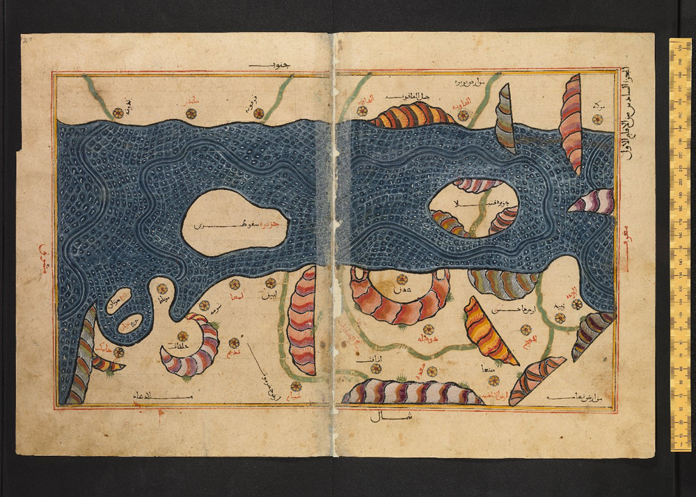
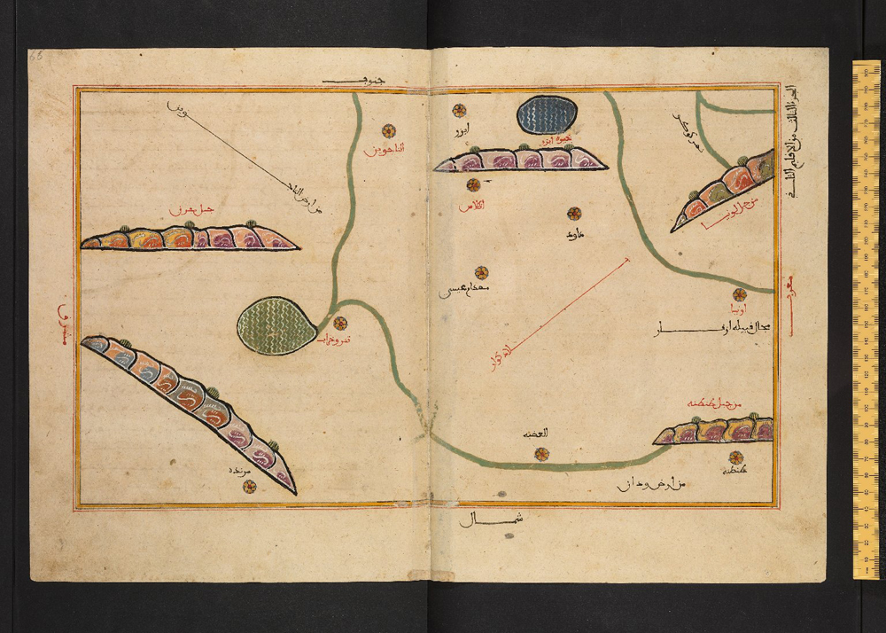
Folio 87b of Bodleian Library MS. Greaves 42, a 14th- or 15th-century Arabic copy of al-Idrisi's Nuzhat al-Mushtaq, showing the Persian Gulf. This is a photograph of a genuine later manuscript copy of al-Idrisi's text, not of the lost 1154 original and not of Konrad Miller's 1929 reconstruction.
| Artist | Muhammad al-Idrisi |
|---|---|
| Date | Text completed 1154 CE at Palermo; no manuscript copy earlier than c. 1325 survives |
| Medium | Arabic geographical treatise (Kitab Nuzhat al-Mushtaq fi'khtiraq al-'Afaq) comprising a descriptive text and 70 sectional maps, transmitted in ink on paper manuscript copies. The original commission is reported, separately, to have included a world map engraved on a silver planisphere; that object does not survive. |
| Dimensions | Not established for a single object. Dimensions vary by manuscript copy and are not published for Bodleian MS. Greaves 42 in the sources consulted. The lost silver planisphere is reported, in modern secondary accounts rather than any verified contemporary measurement, at roughly 300 lb (136 kg). |
| Where it is now | No single original survives. The text is preserved in roughly ten manuscript copies dispersed across several institutions. The manuscript photographed for this record is held by the Bodleian Library, University of Oxford., Bodleian Library, University of Oxford, MS. Greaves 42last confirmed 15 September 2026 |
| Attribution | acceptedAuthorship of the text and its accompanying maps is not disputed: the work is dedicated to Roger II in its own preface and has carried al-Idrisi's name through the entire manuscript tradition. Full note |
| Object type | Map |
| Period | Norman Sicily, 12th century (composition); later Islamic manuscript tradition, 14th-16th century (surviving copies) |
| Cases | Has a provenance gap |
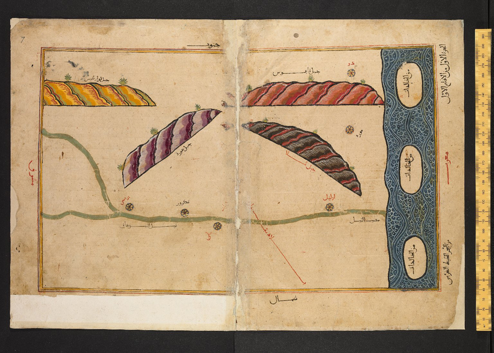
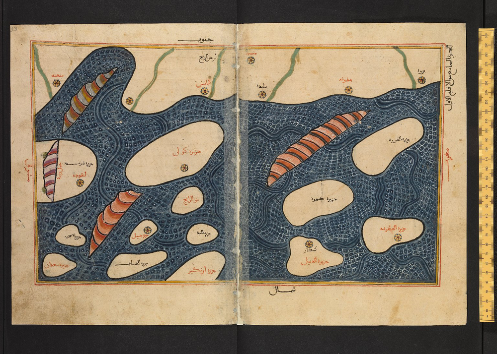
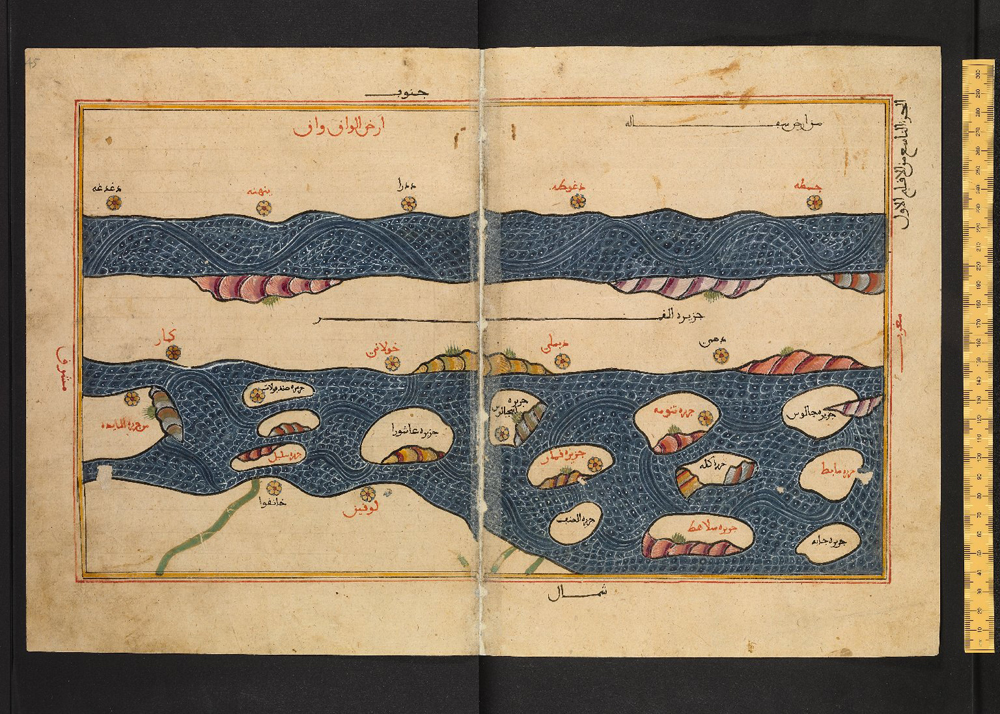
| Inscriptions | Arabic text and toponyms throughout. The sectional maps are captioned by climate zone and section number and are oriented with south at the top and north at the bottom, with Mecca placed near the center, following the convention of the Balkhi school of geography. |
- Where it is now
- No single original survives. The text is preserved in roughly ten manuscript copies dispersed across several institutions. The manuscript photographed for this record is held by the Bodleian Library, University of Oxford.last confirmed 15 September 2026
- Attribution
- accepted
- Provenance
- 4 links2 documented, 1 disputed, 1 unknown
- Sources
- 12 cited
- Last verified
- 15 September 2026Change log
On this page 9 sections
Completed in 1154 for Roger II of Sicily, the Nuzhat al-Mushtaq is a seventy-map Arabic geography compiled by the Andalusi scholar Muhammad al-Idrisi from fifteen years of interviews with travelers, verification by agents sent into the field, and the inherited framework of Ptolemaic and Balkhi-school geography. A companion world map said to have been engraved on a silver disc does not survive, and this record has found no primary source that documents how or exactly when it was lost; that part of the story is report, not record, and is presented that way.
The book itself survives only through later copying: about ten manuscripts worldwide, the earliest from around 1325. This record is illustrated from Bodleian Library MS. Greaves 42, a genuine but partial and anonymous 14th- or 15th-century Arabic copy whose own history is undocumented before its arrival at Oxford in 1678. The image most people picture when they hear 'Idrisi map,' Konrad Miller's 1929 composite reconstruction, is a modern scholarly artifact assembled from later copies and is presented here only as a clearly labeled comparandum, never as the object itself.
Read past the popular version and two disciplined findings emerge: the map's celebrated south-up orientation is a documented Balkhi-school convention al-Idrisi adopted rather than an invention of his own, and the frequent claim that his geography fed European Age-of-Exploration cartography does not survive contact with the fact that no Latin translation existed before 1619. What remains, honestly stated, is still substantial: one of the most systematically compiled geographies of the medieval world, made possible by a Sicilian court willing to fund fifteen years of cross-checked, multilingual fieldwork.
Provenance
Each link is graded. Documented: a cited source supports it. Disputed: the identification is argued but not established. Unknown: no owner for that span, and the gap is not smoothed into a narrative. The grades in the glossary.
- 1138 - 1154Roger II of Sicily, royal court, Palermodocumented
Roger II commissioned al-Idrisi to compile a comprehensive geography over a period reported as fifteen to eighteen years, drawing on interviews with travelers and merchants, verification agents, and prior Islamic and Ptolemaic geographical writing. The text was completed and dedicated to Roger II in 1154, shortly before his death.125
- 1154 - 1160/1161Norman royal court, Palermo (reported: the silver planisphere)disputed
Modern secondary sources report that a silver disc engraved with al-Idrisi's world map was produced alongside the book and was lost or destroyed during the unrest that followed Roger II's death, commonly associated with the 1160-1161 revolt led by Matthew Bonnellus and the anti-Muslim violence in Palermo that accompanied it. No primary account of that unrest consulted for this record names the disc among the palace's contents or describes its destruction. This record treats the disc's very existence, and certainly its fate, as reported rather than documented.1512
- 14th-15th century - 1678Unrecordedunknown
The specific manuscript photographed for this record, Bodleian MS. Greaves 42, was copied by an unnamed scribe at an unrecorded location, dated only by palaeography to the 14th or 15th century. Nothing is recorded of its ownership or location between that copying and its documented arrival in England in the Greaves collection by 1678.3411
- 1678 - presentBodleian Library, University of Oxforddocumented
Acquired as part of the Bodleian's 1678 purchase of the Oriental manuscript collection of the brothers John Greaves (d. 1652), the Gresham College mathematician and astronomer who collected manuscripts during travels in the Ottoman Levant and Egypt in the 1630s, and Thomas Greaves (d. 1676), an Oxford orientalist. The manuscript has remained at the Bodleian since, catalogued as MS. Greaves 42.3411
Technical evidence
| Attribution note | Authorship of the text and its accompanying maps is not disputed: the work is dedicated to Roger II in its own preface and has carried al-Idrisi's name through the entire manuscript tradition. What is not attributable is the execution of any single surviving copy. No manuscript witness is autograph. Bodleian Library MS. Greaves 42, the manuscript photographed for this record, is anonymous and undated; palaeography places it in the 14th or 15th century, one to three centuries after al-Idrisi's death, and its scribe is not recorded. |
|---|---|
| Textual structure | Arabic prose treatise divided into seven latitudinal climate zones after the Ptolemaic system, each zone subdivided into ten sections, giving seventy sectional maps, each accompanied by a descriptive text on the towns, distances, peoples and produce of that section.17 |
| Orientation | South at the top, north at the bottom, with the Arabian peninsula and Mecca placed near the center of the world map, following the convention established by al-Khwarizmi in the 9th century and used by the Balkhi-school geographers al-Balkhi and al-Istakhri in the 10th century.15 |
| This record's manuscript witness | Bodleian Library, University of Oxford, MS. Greaves 42. Arabic manuscript, undated, assigned on palaeographic grounds to the 14th or 15th century. Anonymous scribe. Contains the first three of the work's seven climate zones only, covering territory from the equator to roughly the latitude of North Africa and from the Atlantic coast to eastern China.34 |
| Other principal manuscript witnesses | Bibliotheque nationale de France, MS Arabe 2221, the earliest known surviving copy, dated to around 1325. Bodleian Library MS. Pococke 375, a complete copy of all seven climates made in Cairo in 1553, acquired by the Bodleian in 1692. A more complete copy including the full world map and all seventy sectional maps is held in Istanbul. Roughly ten manuscript copies of the text are known to survive in total; about five preserve the complete text and about eight carry at least some maps.14 |
| The lost silver planisphere (reported) | Modern secondary sources report a world map engraved on a silver disc, produced as part of the same commission, weighing in the region of 300 lb (136 kg). No contemporary measurement, illustration or eyewitness description of the object as it existed has been located for this record; the figures in circulation come from later or modern secondary accounts.15 |
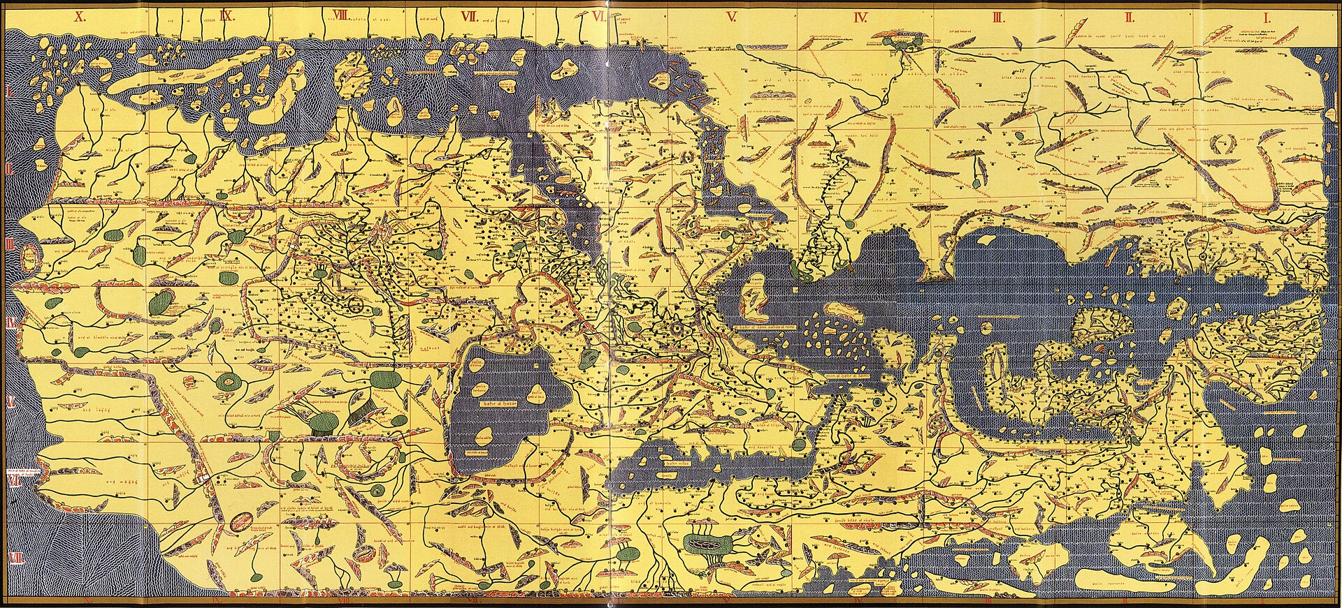
| Konrad Miller's 1929 reconstruction | Charta Rogeriana: Weltkarte des Idrisi vom Jahr 1154 n. Chr., a modern rectangular composite assembled from the seventy sectional maps of later manuscript copies (principally Pococke 375 and/or Arabe 2221) with place names transliterated into the Roman alphabet. A 20th-century scholarly artifact, not a medieval object.9 |
| Earth circumference calculation | Al-Idrisi's team is credited with a calculated figure for the Earth's circumference. Secondary sources quote inconsistent figures and units for this calculation and its margin of error; this record has not been able to establish a single authoritative primary figure and flags the discrepancy rather than resolving it by guesswork.1 |
Images
The record in full
A book of seventy maps, and a lost disc of silver
What is usually called the Tabula Rogeriana is not one object but two, and only one of them survives, and not in its original form. The first is a work of geography: an Arabic treatise titled Nuzhat al-Mushtaq fi'khtiraq al-'Afaq, roughly The Entertainment of One Who Longs to Traverse the Horizons, completed in 1154 for Roger II of Sicily. It divides the inhabited world into seven latitudinal climate zones after the Ptolemaic system, each zone cut into ten sections, giving seventy sectional maps, each paired with a two-page written description of the towns, distances, peoples and produce of that section. The second is a report, separate from the book and much less securely documented, that the same commission also produced a world map engraved on a large silver disc.
The book survives, but not as al-Idrisi left it: it survives only in later copies, the earliest of them dated a century and a half after 1154. The disc does not survive at all. This record covers both honestly, which means treating them differently: the book's transmission can be traced through named, catalogued manuscripts; the disc's fate cannot be traced through any comparable evidence and rests on report rather than record.
The commission: fifteen years at the Norman court
Roger II of Sicily ruled a kingdom that had absorbed a substantial Arabic-speaking, Arabic-literate population along with Byzantine Greek and Latin administrative traditions, and his court at Palermo was unusual in medieval Europe for employing Muslim scholars, physicians and officials alongside Christian ones. Al-Idrisi, an Arab-Andalusi geographer of the Hammudid line who had already travelled widely across the Mediterranean and Anatolia, arrived at that court, by his own account and the account of later biographers, after instability in al-Andalus made his position there difficult. He remained at Roger's court for some fifteen to eighteen years working on the geography project; sources differ on the exact figure, and this record has not been able to reconcile the discrepancy from a primary source.
Al-Idrisi describes his method in terms that later scholarship treats as a genuine statement of practice rather than a formula: he says he retained from his informants only that part of their testimony 'on which there was complete agreement and seemed credible, excluding what was contradictory.' Roger II is reported to have taken part personally in some of the interviews with travelers and merchants passing through Sicily, and al-Idrisi is also reported to have sent out agents to check travelers' accounts against each other before anything was recorded as established.
How much of it is fieldwork, and how much is compiled from books
This is where popular accounts of the Tabula Rogeriana tend to overstate the case, and where the honest answer is that both things are true at once. Al-Idrisi's project drew on interviews with sailors, merchants and travelers who had first-hand experience of the coasts and roads they described, and on agents sent to particular regions to corroborate what they said. That is real fieldwork, in the sense that it produced information not available from any earlier written geography, and it shows in the noticeably finer detail given to regions close to Sicily and to the trade routes the Norman kingdom actually used.
At the same time, the intellectual scaffolding of the work is compiled, not observed. Al-Idrisi organizes his seventy sections within the seven-climate system inherited from Ptolemy's Geography, known to him through Arabic translation, and he draws on three centuries of prior Islamic geographical writing, including the tradition associated with the Balkhi school of Baghdad. Earlier Muslim geographers had already corrected some of Ptolemy's errors using exactly the kind of merchant testimony al-Idrisi also relied on, for instance rejecting Ptolemy's claim that the Indian Ocean was a closed sea and revising his gross overestimate of the length of the Mediterranean. Al-Idrisi's achievement was to combine an inherited written framework with a genuinely new round of empirical checking at an unusually large and systematic scale for his period, not to invent either the framework or the method of checking from nothing.
Why south sits at the top
Readers meeting a reproduction of the Idrisi world map for the first time are usually struck by its orientation: south at the top, north at the bottom, with the Arabian peninsula and Mecca near the center. This was not a personal choice by al-Idrisi. The convention was established a good two centuries earlier by the mathematician and geographer al-Khwarizmi in the ninth century, and it was the standard orientation used by the Balkhi school geographers Abu Zayd al-Balkhi and al-Istakhri in the tenth century, whose maps al-Idrisi's tradition inherited.
Why the convention itself exists is argued rather than settled. Some historians read it as an expression of religious orientation toward Mecca, on the model of the qibla; others point out that the earliest of these Muslim world maps carry very little explicit religious iconography, and treat the south-up format as inherited technical convention rather than devotional statement. This record follows the more cautious position: the orientation is well documented as a Balkhi-school convention that al-Idrisi adopted, but the reason for the convention's original adoption is argued, not proven, and this record does not take a side beyond reporting that the dispute exists.
The silver planisphere: what is reported, and what is documented
Modern accounts of the Tabula Rogeriana almost all repeat a striking detail: that alongside the book, al-Idrisi's team produced a second version of the world map engraved on a massive disc of silver, reportedly weighing in the region of 300 lb, and that this disc was lost during unrest that followed Roger II's death. This record has traced that claim as far as it can be traced, and the honest result is that it rests on later report rather than a documented event.
Al-Idrisi's own text, so far as it has been checked for this record, does not itself describe or refer to a silver planisphere. The claim comes from later biographical and bibliographical notices about al-Idrisi, repeated and elaborated in modern secondary literature, not from a surviving eyewitness account of the object or of its destruction. The circumstantial context usually attached to the disc's loss is the period of unrest in Palermo after Roger II's death in February 1154, under his son and successor William I: the assassination of the chief minister Maio of Bari in November 1160, the subsequent revolt led by Matthew Bonnellus in alliance with Simon and Tancred, the seizure and looting of the royal palace, and an anti-Muslim pogrom in Palermo that a contemporary chronicle attributes to the narrowness of the Muslim quarter's streets for having limited its scope rather than to any intervention that stopped it. What none of the primary narrative of that revolt, so far as consulted for this record, actually says is that a silver planisphere was among the palace's contents or was destroyed. The disc's loss is plausible given the palace was looted at exactly the right moment, and it is repeated consistently across modern sources, but it is not, on the evidence gathered here, a documented event in the way the palace looting itself is documented. This record grades it accordingly.
What survives: a manuscript tradition, not a manuscript
Because the original disc and the original presentation copy of the book are both gone, everything known of the Tabula Rogeriana today comes through later copying. Roughly ten manuscript copies of the Nuzhat al-Mushtaq are known to survive worldwide; about half preserve the complete text, and about eight carry at least some of the seventy sectional maps. The earliest known copy, MS Arabe 2221 in the Bibliotheque nationale de France in Paris, is dated to around 1325, some 170 years after composition. A more complete copy, containing the world map and all seventy sectional maps, is held in Istanbul. The Bodleian Library in Oxford holds two separate Arabic copies: MS. Pococke 375, made in Cairo in 1553 and containing descriptions and maps for all seven climates, acquired by the library in 1692; and MS. Greaves 42, undated but assigned on palaeographic grounds to the 14th or 15th century, which is incomplete, carrying only the first three of the work's seven climates, covering territory from the equator to roughly the latitude of North Africa and from the Atlantic coast to eastern China.
No two of these copies necessarily agree in every particular, and the copying process over two and three centuries is exactly the kind of process in which toponyms drift, sections are recombined, and later copyists' own knowledge or ignorance of geography leaves traces. Any specific claim about 'the' Idrisi map has to specify which copy it is drawn from.
This record's manuscript: Bodleian MS. Greaves 42
The photographs used in this record are of MS. Greaves 42, and it is worth being precise about what that manuscript is and is not. It is a genuine Arabic-language copy of al-Idrisi's Nuzhat al-Mushtaq, confirmed as such by the Bodleian Library's own published cataloguing of its Islamic manuscript holdings, not a modern facsimile or a differently titled work that happens to share subject matter. It is partial, containing only the first three of the work's seven climate zones. It is anonymous: no scribe is named, no place of copying is recorded, and its date rests on palaeographic estimate rather than a colophon, placing it one to three centuries after al-Idrisi's own lifetime.
Its documented history begins only in 1678, when the Bodleian purchased the Oriental manuscript collection assembled by the brothers John Greaves, the Gresham College mathematician and astronomer who travelled through the Ottoman Levant and Egypt in the 1630s acquiring manuscripts and instruments, and Thomas Greaves, an Oxford orientalist. That purchase is the origin of the 'Greaves' manuscripts at the Bodleian generally, of which this is number 42. Between the manuscript's copying, sometime in the 14th or 15th century, and its documented arrival in the Greaves collection by 1678, nothing is recorded: where it was, who owned it, and how one of the Greaves brothers obtained it are all open questions this record has not been able to close.
Konrad Miller's 1929 reconstruction, and why it is not the medieval map
The single image most commonly reproduced as 'the Idrisi map,' including on general encyclopaedias and in casual online use, is not a photograph of any medieval object. It is a modern composite drawn in 1928-1929 by the German cartographic historian Konrad Miller, titled Charta Rogeriana: Weltkarte des Idrisi vom Jahr 1154 n. Chr. Miller took the seventy separate sectional maps as they appear in later manuscript copies, principally Bodleian MS. Pococke 375 and/or Bibliotheque nationale de France MS Arabe 2221, and assembled them into a single continuous rectangular world map, transliterating the Arabic place names into the Roman alphabet for a modern readership.
Two things follow from that description and both matter for how this image should be used. First, it is a 20th-century scholarly artifact, not a medieval one: Miller made interpretive choices about how sectional maps drawn as separate two-page spreads, sometimes inconsistently across manuscript copies, should be stitched into one continuous sheet, and those choices are his, not al-Idrisi's. Second, its correspondence with the circular format long associated with al-Idrisi's tradition is itself part of an unresolved scholarly question, addressed below, about whether that circular format originates with al-Idrisi at all. Because Miller's reconstruction is public domain and visually striking, it circulates far more widely than any actual manuscript photograph, and that popularity is precisely why this record separates it out: fame is not the same thing as fidelity to the object.
A rival circular map, a century earlier: the Book of Curiosities problem
A further complication, not usually mentioned outside specialist literature, concerns the well-known circular world map long treated as al-Idrisi's own design. In 2000, the Bodleian Library and the University of Oxford's Oriental Institute began studying an anonymous Fatimid-era Arabic cosmography acquired by the library in 2002, known as the Book of Curiosities (Kitab Gharaib al-Funun), originally compiled in Cairo between about 1020 and 1050, with the sole surviving copy dated to the early 13th century. That work contains its own circular world map, of a type closely resembling the map long labelled 'the Idrisi world map.'
This raises a genuine question of priority that the discovery of the Book of Curiosities put back into play: was the circular world map format invented by al-Idrisi for his 1154 treatise, or did it already exist in the Fatimid geographical tradition a century before him, making the label 'Idrisi world map' a misattribution inherited from modern scholarship rather than medieval practice? The historian Yossef Rapoport, who co-led the Book of Curiosities research project, has argued that the map's different color palette relative to the rest of that manuscript is evidence it was a later interpolation copied from the al-Idrisi tradition rather than an independent precursor to it, which would restore al-Idrisi's priority; but this is Rapoport's argued position, not a settled consensus, and this record has not found a published rebuttal to weigh against it.
What the map gets right, and where it becomes speculative
Judged against later, more precisely surveyed maps, the Idrisi tradition's accuracy is uneven in a pattern that tracks the availability of first-hand testimony. The Mediterranean basin, the regions the Norman kingdom traded with and travelled through, and the general shape of the connected Indian Ocean and Atlantic are rendered with a level of relative correctness that impressed 19th-century Orientalist scholars when the work was properly studied again. Al-Idrisi's team also arrived at a calculated figure for the Earth's circumference; modern secondary sources disagree on which measurement should be quoted and in which units, which is itself worth recording rather than silently resolving, and this record has not been able to establish a single authoritative figure from a primary calculation.
Further from Sicily and from the trade routes reachable by informants at Roger's court, the map becomes progressively more schematic and, in places, simply wrong by inheritance rather than by new error: it repeats Ptolemy's fictitious 'Mountains of the Moon' as the source of the Nile, and it omits central and southern Africa almost entirely rather than guessing at their shape. This unevenness is not a flaw specific to al-Idrisi; it is the expected signature of a compilation method that mixes verified local testimony with an inherited classical framework, and reading the map's reliability as a gradient from the Mediterranean outward, rather than as a single verdict of 'accurate' or 'inaccurate,' is the more defensible way to use it.
An influence claim that needs qualifying
It is often suggested, in popular accounts, that al-Idrisi's geography fed into the European voyages of exploration of the following centuries. The chronology does not support a strong version of that claim. No medieval Latin translation of the Nuzhat al-Mushtaq is known to have circulated in Europe during the relevant period; the first Latin edition, by the Maronite scholar Gabriel Sionita, was printed in Paris only in 1619, more than a century after Columbus and Vasco da Gama, and well after the main phase of Iberian oceanic exploration that a strong influence claim would require. Wider European recognition of the scale and quality of al-Idrisi's achievement had to wait longer still, for the rise of academic Oriental studies in the 19th century, which is also when serious critical study, translation into further European languages, and eventually Miller's reconstruction all followed.
None of this diminishes the work on its own terms. It means the accurate claim is narrower than the popular one: the Nuzhat al-Mushtaq was, by the assessment of the scholars who examined it once it became properly accessible, one of the most detailed and systematically compiled works of geography produced anywhere in the medieval world, and it stands as material evidence of exactly how much cross-cultural scientific exchange the multi-confessional Norman court of Sicily was capable of sustaining. It is not, on the evidence available, a demonstrated causal input into the specific navigational project of the Iberian voyages of discovery three and a half centuries later.
After Roger: a second geography, now lost, and the geographer's own exile
Roger II died in February 1154, close to the completion of the project bearing his name. Al-Idrisi remained at the Sicilian court under Roger's son and successor, William I, known to later historiography as William the Bad, and is reported to have produced for him an enlarged and updated version of the geography, titled Rawd al-Uns wa-Nuzhat al-Nafs, roughly The Garden of Intimacy and the Delight of the Soul. That work does not survive in any known copy; it is known only by title and description in later bio-bibliographical sources, which places it in a strictly weaker evidentiary category than the Nuzhat al-Mushtaq itself, which at least survives in ten manuscript witnesses.
Al-Idrisi's own departure from Sicily is usually connected to the same period of anti-Muslim unrest under William I discussed above in connection with the disputed fate of the silver disc, though, again, no source consulted for this record specifically names al-Idrisi as a witness to or victim of that unrest; the connection is inferential, based on timing, not documented by a source describing his departure directly. He is reported to have died in 1165 or 1166, and even his place of death is not agreed in the sources consulted: some give Sicily, others his birthplace of Ceuta in North Africa. Beyond the two geographical works, he is also credited with a pharmacological treatise cataloguing simple medicinal substances with their names given in multiple languages, reflecting the same comparative, cross-checking habit of mind visible in the geography.
What is being done with it now
The most active recent work on this material is not textual editing but physical reconstruction. The Factum Foundation, a Madrid-based organization specializing in digital recording and physical facsimile production of cultural heritage, has an ongoing project titled Re-creating the Lost Silver Map of al-Idrisi, which uses the surviving sectional maps from the Nuzhat al-Mushtaq manuscript tradition to attempt a reconstruction, focused initially on the Mediterranean and Arabian Gulf sections, of what the lost silver disc's map content might have looked like. This is explicitly presented as a modern reconstruction project working from the surviving book, not as a discovery of the disc itself or of new documentary evidence for its fate, and this record treats it accordingly: it is evidence of continuing scholarly and conservation interest in the object, not evidence that resolves the underlying disputes about the disc's original appearance or its loss.
The artist
Abu Abd Allah Muhammad ibn Muhammad ibn Abd Allah ibn Idris al-Sharif al-Idrisi
Al-Idrisi is documented well enough to be a real historical figure rather than a legend attached to a famous map, but the documentation is biographical rather than personal: dates, posts and works are recorded by later bio-bibliographers, while his own voice survives mainly in the preface and method statements of the geography itself. He is best understood as a working scholar who spent the greater part of his career, by his own report, checking one traveler's account against another's, rather than as a solitary genius who produced a masterpiece from nowhere.
Related works
| Work | Relation | Where it is |
|---|---|---|
| Book of Curiosities (Kitab Gharaib al-Funun) Anonymous, Fatimid Cairo | An earlier Arabic cosmography, composed c. 1020-1050, whose sole surviving copy (early 13th century) contains a circular world map closely resembling the map long attributed to al-Idrisi. A live scholarly question, not resolved here, concerns which tradition originated the circular format. Acquired by the Bodleian in 2002; studied jointly by the Bodleian and Oxford's Oriental Institute. Yossef Rapoport has argued the map is a later interpolation copied from the al-Idrisi tradition, not an independent precursor to it. | Bodleian Library, University of Oxford, MS. Arab. c. 90 |
| Nuzhat al-Mushtaq, complete copy Scribe unrecorded, after al-Idrisi | Sister manuscript witness to the same text, complete where MS. Greaves 42 is partial Made in Cairo in 1553; acquired by the Bodleian in 1692; contains descriptions and maps for all seven climate zones. | Bodleian Library, University of Oxford, MS. Pococke 375 |
| Nuzhat al-Mushtaq, earliest known copy Scribe unrecorded, after al-Idrisi | The oldest surviving manuscript witness to the text Dated to around 1325, roughly 170 years after composition. | Bibliotheque nationale de France, Paris, MS Arabe 2221 |
| Charta Rogeriana: Weltkarte des Idrisi vom Jahr 1154 n. Chr. Konrad Miller | Modern composite reconstruction of al-Idrisi's world map, assembled from the seventy sectional maps of later manuscript copies Published Stuttgart, 1928-1929. A 20th-century scholarly artifact, not a medieval object; do not confuse with a photograph of any manuscript. | Multiple institutional holdings (e.g. Library of Congress); widely reproduced online |
| Coronation Mantle of Roger II Royal workshop (tiraz), Palermo | Another documented commission of the same patron, Roger II, made at the same court in the same decade Already a separate published record on this site (coronation-mantle-roger-ii-vienna); referenced here for context only, not duplicated. | Kunsthistorisches Museum, Vienna |
Open questions
- Did the silver planisphere exist substantially as later sources describe it? Al-Idrisi's own text, as consulted for this record, does not mention it, and the claim rests on later biographical notice rather than a contemporary description.
- If the disc existed, exactly how and when was it lost? The common attribution to the 1160-1161 unrest under William I is plausible by timing but is not stated in the primary narrative of that unrest consulted for this record.
- Who copied Bodleian MS. Greaves 42, and where and when precisely? Palaeography gives only a two-century window (14th-15th century); no colophon or scribal note has been reported.
- How and when did John or Thomas Greaves acquire this specific manuscript before its 1678 sale to the Bodleian? The Greaves collection's purchase by the library is documented; the individual manuscript's earlier history is not.
- Does the circular world map format associated with al-Idrisi actually originate with him, or does it predate him in the Fatimid tradition represented by the Book of Curiosities? Rapoport has argued for al-Idrisi's priority; this record has not located a published rebuttal.
- What is the correct figure, in a consistent unit, for al-Idrisi's calculated Earth's circumference, and by what method was it derived? Secondary sources disagree and this record has not traced the calculation to a primary figure.
- Which of the ten surviving manuscript copies, if any, most faithfully preserves al-Idrisi's original arrangement of the seventy sectional maps, given that Konrad Miller had to choose between conflicting later copies to build his 1929 composite?
Questions about this object
What is Nuzhat al-Mushtaq fi'khtiraq al-'Afaq (The Tabula Rogeriana)?
Nuzhat al-Mushtaq fi'khtiraq al-'Afaq (The Tabula Rogeriana) is a map, dated text completed 1154 CE at Palermo; no manuscript copy earlier than c. 1325 survives. Medium: Arabic geographical treatise (Kitab Nuzhat al-Mushtaq fi'khtiraq al-'Afaq) comprising a descriptive text and 70 sectional maps, transmitted in ink on paper manuscript copies. The original commission is reported, separately, to have included a world map engraved on a silver planisphere; that object does not survive.
Who made Nuzhat al-Mushtaq fi'khtiraq al-'Afaq (The Tabula Rogeriana), and is the attribution settled?
The attribution to Muhammad al-Idrisi is recorded here as accepted. Authorship of the text and its accompanying maps is not disputed: the work is dedicated to Roger II in its own preface and has carried al-Idrisi's name through the entire manuscript tradition. What is not attributable is the execution of any single surviving copy. No manuscript witness is autograph. Bodleian Library MS. Greaves 42, the manuscript photographed for this record, is anonymous and undated; palaeography places it in the 14th or 15th century, one to three centuries after al-Idrisi's death, and its scribe is not recorded.
Where is Nuzhat al-Mushtaq fi'khtiraq al-'Afaq (The Tabula Rogeriana) now?
No single original survives. The text is preserved in roughly ten manuscript copies dispersed across several institutions. The manuscript photographed for this record is held by the Bodleian Library, University of Oxford., Bodleian Library, University of Oxford, MS. Greaves 42. Last confirmed 15 September 2026. Bodleian Library cataloguing (Digital Bodleian / Fihrist), and the Bodleian's own published account of its al-Idrisi holdings.
What is still unknown about Nuzhat al-Mushtaq fi'khtiraq al-'Afaq (The Tabula Rogeriana)?
Did the silver planisphere exist substantially as later sources describe it? Al-Idrisi's own text, as consulted for this record, does not mention it, and the claim rests on later biographical notice rather than a contemporary description.
Sources
- 1Wikipedia, 'Tabula Rogeriana'. Tertiary source; flagged for replacement with S. Maqbul Ahmad's chapter on al-Sharif al-Idrisi in the History of Cartography (University of Chicago Press) where a legible copy can be obtained. en.wikipedia.org/wiki/...
- 2Wikipedia, 'Muhammad al-Idrisi'. Tertiary source; flagged for replacement with a scholarly biography. en.wikipedia.org/wiki/...
- 3Biblissima IIIF manifest, 'Oxford. Bodleian Library, MS. Greaves 42', consolidating Digital Bodleian's own catalogue description of the manuscript. iiif.biblissima.fr/collections/...
- 4Bodleian Libraries, 'Medieval Islamic maps of the world', The Conveyor (Bodleian blog), for the library's own account of MS. Greaves 42 and MS. Pococke 375. blogs.bodleian.ox.ac.uk/theconveyor/...
- 5Sacred Footsteps, 'The Complex Story Behind Al-Idrisi's Iconic World Map'. Popular history site citing named scholars (Yossef Rapoport among them); flagged as secondary rather than primary. sacredfootsteps.com/2022/...
- 6Factum Foundation, 'al-Idrisi and Roger II: Mapping The World in the Twelfth Century', for the ongoing digital reconstruction project and its own account of the silver map's loss. factumfoundation.org/our-projects/...
- 7Wikipedia, 'Nuzhat al-Mushtaq'. Tertiary source, used for structural detail on the work's title and organization. en.wikipedia.org/wiki/...
- 8Wikipedia, 'Book of Curiosities'. Tertiary source, used for the manuscript's acquisition date, composition date and authorship. en.wikipedia.org/wiki/...
- 9Wikimedia Commons API (imageinfo/extmetadata) for File:Book of Roger MS. Greaves 42 9b.jpg, 13b.jpg, 49b.jpg, 87b.jpg, 94b.jpg and File:TabulaRogeriana.jpg, verifying licence, credit line, folio subject and date attribution for each file. commons.wikimedia.org/w/...
- 10Simerg, interview with Yossef Rapoport and Emilie Savage-Smith, authors of 'Lost Maps of the Caliphs', on the Book of Curiosities and its circular world map's relationship to the al-Idrisi tradition. simerg.com/2020/...
- 11Oxford LibGuides, 'Middle East - Manuscripts: Asian and Middle Eastern', Bodleian Libraries, for the 1678 purchase of the John and Thomas Greaves manuscript collection. libguides.bodleian.ox.ac.uk/c.php
- 12Wikipedia, 'Matthew Bonnellus'. Tertiary source, consulted specifically to check whether the primary narrative of the 1160-1161 Palermo revolt mentions a silver planisphere; it does not. en.wikipedia.org/wiki/...

Last verified 15 September 2026 · Published 15 September 2026
Change log
15 September 2026 - Record created at the house standard: researched narrative, technical evidence, maker dossier, graded provenance chain, prices with hammer and premium separated, related works, open questions and sources.