Carta Universal de Juan de la Cosa
Juan de la Cosa · 1500, per its own legend; a substantial minority of cartographic historians argue the surviving sheet is a copy or composite completed after 1500, in some readings as late as 1508-1509 (see narrative)
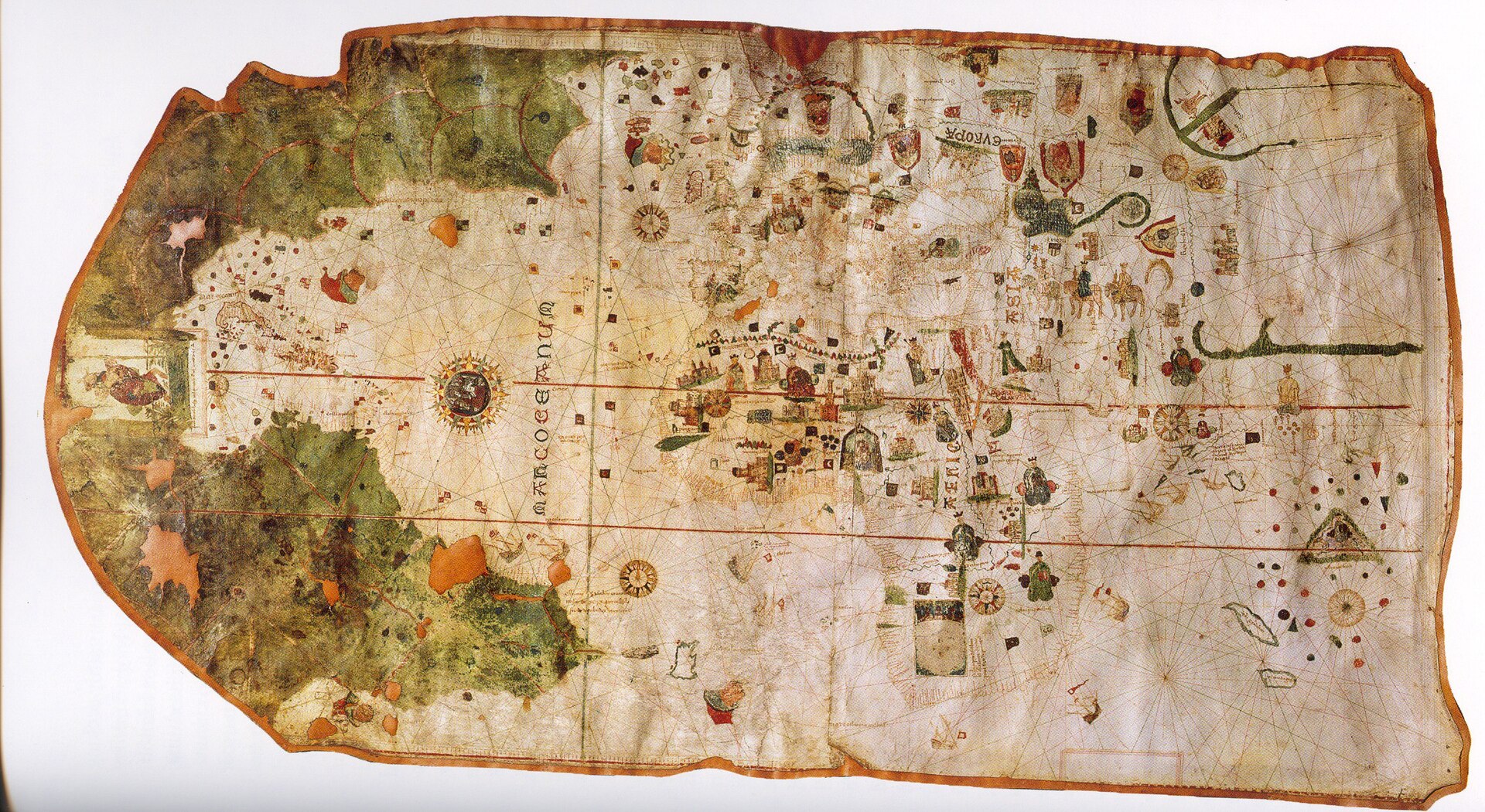
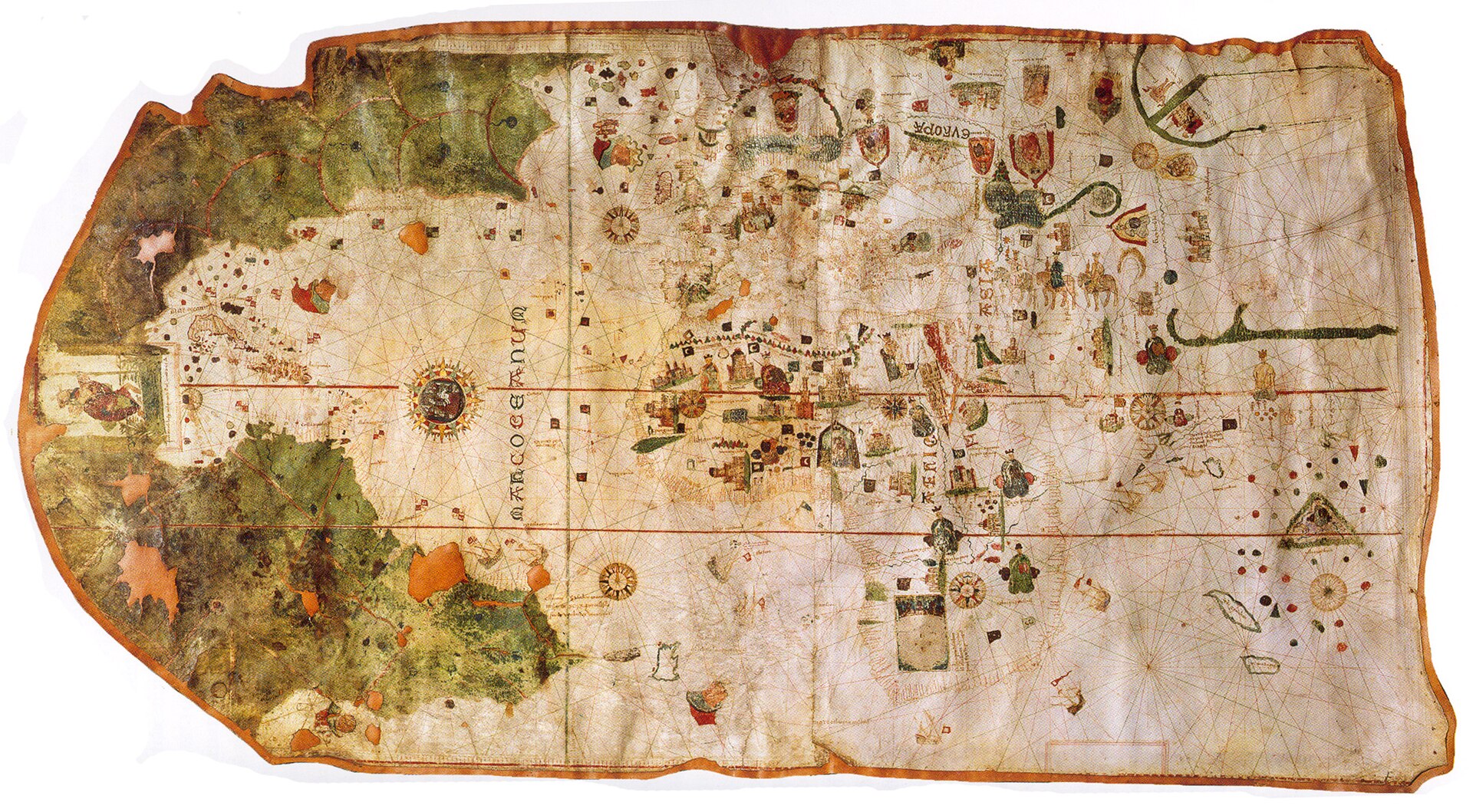
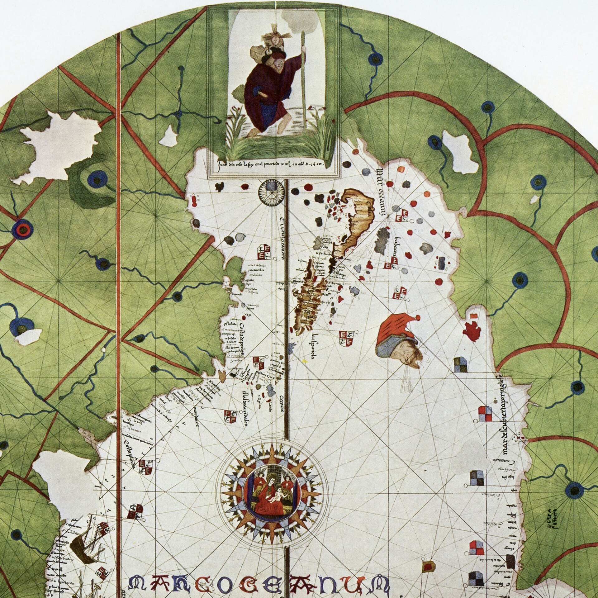
The full chart, rotated for legibility. The New World appears in green at the top; the uncolored Old World occupies the center and lower portion. Museo Naval, Madrid.
| Artist | Juan de la Cosa |
|---|---|
| Date | 1500, per its own legend; a substantial minority of cartographic historians argue the surviving sheet is a copy or composite completed after 1500, in some readings as late as 1508-1509 (see narrative) |
| Medium | Ink and watercolor pigment on two joined sheets of parchment (calfskin), sewn onto a canvas backing |
| Dimensions | 93 x 183 cm per the most detailed published Spanish scholarship (Martin-Meras Verdejo, 2000); commonly given as 96 x 183 cm in English-language sources, with the parchment's irregular edge reaching about 186 cm at its widest point |
| Where it is now | Museo Naval, Madridlast confirmed 18 September 2026 |
| Inventory number | Not documented in any source consulted for this record. The Museo Naval's own published material identifies the chart by title (Carta Universal de Juan de la Cosa) and gallery location, not by a quoted registry or accession number, and no scholarly citation found for this record gives one either. If a modern internal inventory number exists, it is not publicly quoted; state this plainly rather than guessing at a number. |
| Attribution | DisputedThe chart's own legend claims sole authorship by Juan de la Cosa, made at the port of Santa Maria in 1500. Full note |
| Object type | Map |
| Period | Castilian, Age of Discovery, circa 1500 |
| Cases | Disputed attribution · Has a provenance gap · Rediscovered |
| Inscriptions | Juan de la cosa la fizo en el puerto de S: ma en ano de 1500 (Juan de la Cosa made it in the port of Santa Maria in the year 1500), inscribed beneath the Saint Christopher cartouche over Central America. A second cartouche in the lower right margin is left blank, apparently reserved for text never added. House style here omits the original Spanish accents. |
| Owners on record | 8 links7 documented, 1 unknown |
| Sources | 13 cited |
About this record Last verified 18 September 2026 · 13 sources cited · Change log
On this page 10 sections
ContentsClose
Drawn in 1500 by a Castilian pilot who had crossed the Atlantic with Columbus twice and charted the coast of northern South America himself, this parchment chart is the earliest surviving European map to show any part of the Americas from direct exploration rather than theory. Its correct outline of Cuba as an island, drawn by a man who had sworn six years earlier that Cuba was part of Asia, is the single most argued-over detail in a genuine, unresolved scholarly dispute over whether the surviving sheet is de la Cosa's own 1500 original or a later copy retouched by another hand.
The chart vanished from the documentary record for roughly three centuries after 1514 and resurfaced in a Paris shop, bought in 1832 by Baron Walckenaer and identified as historically significant that same spring by Alexander von Humboldt. Spain bought it back at Walckenaer's 1853 estate sale for 4,321 francs, and it has been the Museo Naval's signature holding in Madrid ever since, interrupted only by a wartime evacuation to France, Catalonia, and Geneva between 1936 and 1939.
Its maker did not survive it by long. Juan de la Cosa, who had sailed with Columbus, Ojeda, and Vespucci, died at Turbaco, near Cartagena, on 28 February 1510, struck by poisoned arrows during a landing he had personally advised against.
Provenance
Each link is graded. Documented: a cited source supports it. Disputed: the identification is argued but not established. Unknown: no owner for that span, and the gap is not smoothed into a narrative. The grades in the glossary.
- 1500 - 1503Juan de la Cosadocumented
The chart's legend states it was made by Juan de la Cosa at the port of Santa Maria in 1500. In 1503 de la Cosa presented two sea charts of the Indies to Ferdinand and Isabella at Segovia; whether one of the two was this exact sheet, or an updated version of the same underlying chart, is not established.1
- 1503 - 1514Bishop Juan Rodriguez de Fonseca, administrator of the Indiesdocumented
The two charts presented in 1503 are thought to have passed into Fonseca's keeping. The chronicler Pedro Martir de Angleria recorded examining charts by de la Cosa in Fonseca's office in a text dated 4 December 1514.1
- 1514 - 1832Unknownunknown
No document places the chart anywhere for roughly three centuries. It resurfaces already in commercial hands in a Paris shop. How it left Spain, and whether that departure was lawful, is not documented; a 2024 article by Luisa Martin-Meras Verdejo proposes it amounted to a theft from a Spanish archive, a recent hypothesis not yet independently confirmed by other historians in the sources consulted.1
- 1832 - 1852Baron Charles Athanase Walckenaer, Parisdocumented
Purchased from a Paris dealer early in 1832. Shown that same spring to Alexander von Humboldt, who was the first to publicize the chart's significance. Ramon de la Sagra published its American portion in 1837; the Viscount of Santarem reproduced its African portion in 1842.1
- 1852 - 1853Estate of Baron Walckenaer, sold at auctiondocumented
Walckenaer died in 1852 and his library went to auction. Ramon de la Sagra alerted the Spanish Ministry of Marine, which authorized him to bid for Spain. Spain won the chart for 4,321 francs.1
- 1853 - 1936Museo Naval, Madriddocumented
Entered the Museo Naval's Sala de Descubrimientos in 1853 and has been the museum's central exhibit since.1
- 1936 - 1939Museo Naval collection, evacuated with Spain's Tesoro Artisticodocumented
Evacuated from Madrid to Valencia in November 1936 during the Spanish Civil War, following the Republican government, then to Barcelona, then Girona province, then in February 1939 to the League of Nations headquarters in Geneva. After the war the League handed the collection to the Franco government, and the chart returned to the Museo Naval on 3 June 1939. A 2024 study by Luisa Martin-Meras Verdejo treats this as the second of two departures from Spain in the chart's history.1
- 1939 - presentMuseo Naval, Madriddocumented
On permanent exhibition since its 1939 return, never restored. A handmade facsimile by the museum's own cartographer, Juan Pedro Suarez Davila, substituted for the original on display from 1988 to 1992. The Factum Foundation produced a new elevated-print facsimile in 2021 using a Lucida 3D scanner, exhibited at the Spanish Gallery in Bishop Auckland; whether the Museo Naval has since substituted this or any facsimile for the original on permanent display is not confirmed in the sources consulted.14
Prices realised
| Date | Sale | Estimate | Result | Note |
|---|---|---|---|---|
| 1852-1853 | Estate sale of the library of Baron Charles Athanase Walckenaer, Paris (the specific auction house is not named in the sources consulted) | Not documented | Hammer 4,321 francs With premium Not specified; sources do not distinguish a hammer price from an all-in price for this sale French franc | Ramon de la Sagra bid for Spain's Ministry of Marine after alerting it to the sale. This is the only recorded sale of the chart since it left Bishop Fonseca's custody in the early sixteenth century; it has not been sold at auction since entering the Museo Naval in 1853. |
Hammer is the price at which the bidding stopped; with premium adds the fee the house charges the buyer on top. Hammer price and buyer's premium in the glossary.
Technical evidence
| Attribution note | The chart's own legend claims sole authorship by Juan de la Cosa, made at the port of Santa Maria in 1500. Cartographic historians dispute whether the surviving sheet is that 1500 original, a later copy of a lost original, or, on one scholar's reading, a de la Cosa sketch completed and enriched by another cartographer. A 1987 pigment analysis found materials consistent with a 1500 execution and no evidence of later repainting, which supports an early date for the physical object but does not by itself settle whether a single hand or several produced the composition. See Narrative, 'The authorship and dating dispute.' |
|---|---|
| Support | Two joined sheets of calfskin parchment sewn onto a canvas backing. The join falls near Italy and North Africa; the sheets are asymmetric because the western sheet follows the natural shape of the animal's neck.1 |
| Medium | Ink and watercolor pigment. The New World is painted green; the Old World is left uncolored parchment.1 |
| Dimensions | 93 x 183 cm per Martin-Meras Verdejo (2000); commonly given as 96 x 183 cm in English-language sources, with the parchment's irregular edge reaching about 186 cm at its widest point.124 |
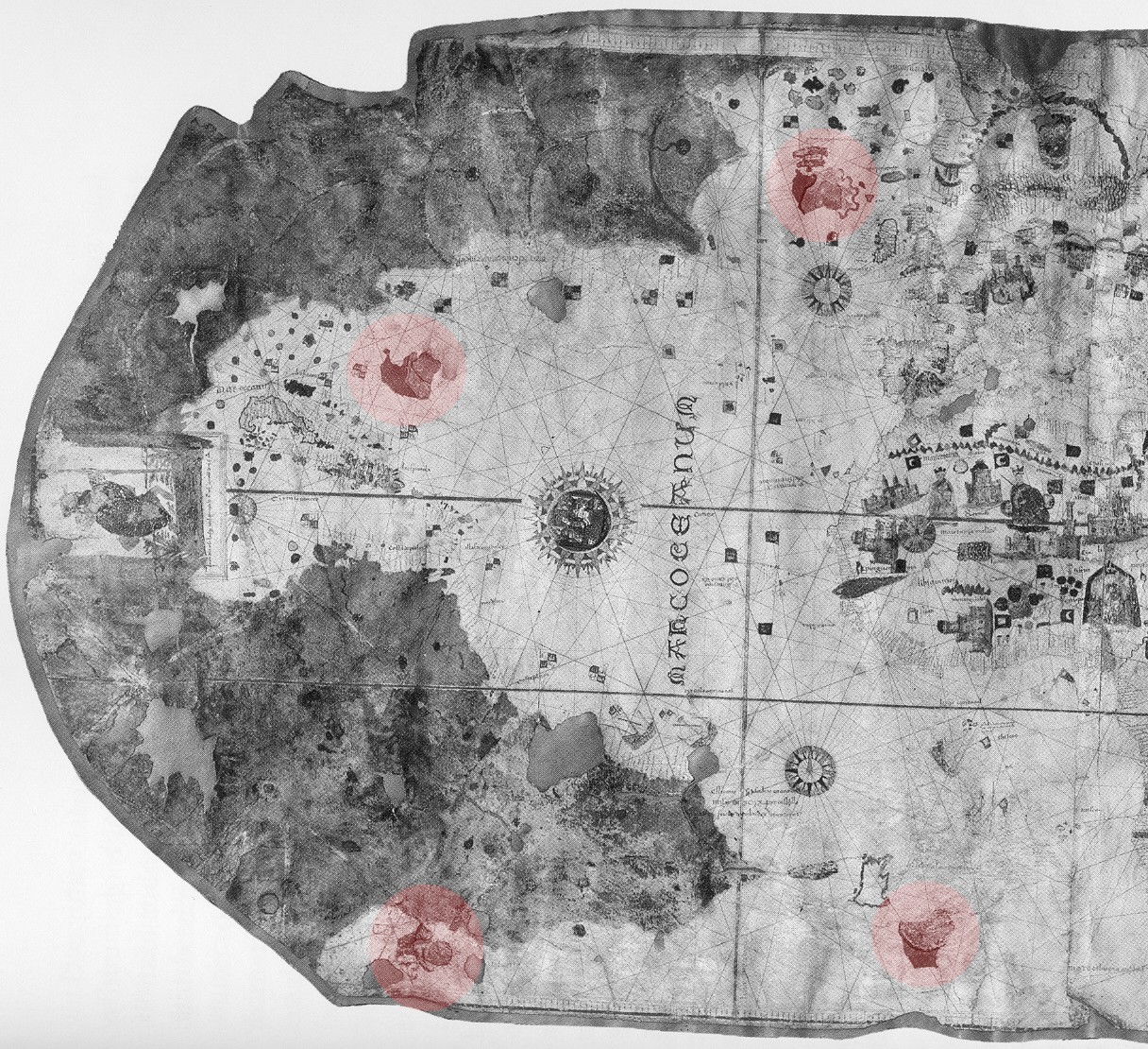
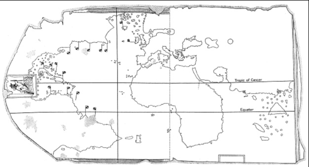
| Reference lines and wind roses | Two principal 32-point wind roses (one south of India, a larger one at the center of the Atlantic), each the center of a circle of 16 smaller secondary wind roses that do not intersect one another. Three ruled straight lines are identified as the equator (circulo equinoccial), the Tropic of Cancer (circulo cancro), and a north-south meridian through the Azores and Cape Verde, which historians variously read as the Alexandrine line of the 1493 bull Inter Caetera, the 1494 Treaty of Tordesillas meridian, or the line of zero magnetic declination.1 |
| Scale | Two unmarked dot-scales, thought to represent intervals of about 50 miles, set in the margins of the western half. The New World appears drawn at a different, larger scale than the Old World, in a ratio estimated at about 1.4 to 1. No coordinate system or projection is stated on the sheet itself; a 2010 cartometric analysis by Robles Macias proposes a specific projection consistent with the Atlantic coastlines.113 |
| Legend | Juan de la cosa la fizo en el puerto de S: ma en ano de 1500 (Juan de la Cosa made it in the port of Santa Maria in the year 1500), beneath the Saint Christopher cartouche over Central America. A second cartouche, lower right, is left blank.12 |
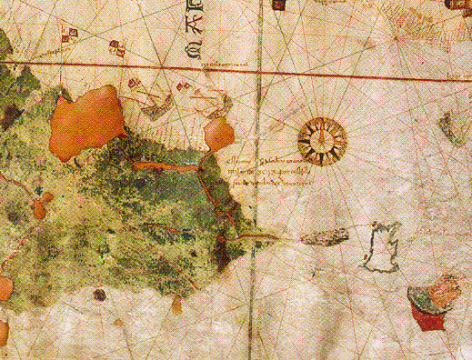
| Condition | Generally good, with some flaking losses near the top of the sheet and damage attributed to an unspecified fire. Never restored. Many New World place names are illegible.1 |
| Technical analysis | In 1987 the Documentation Laboratory of the Museo del Prado analyzed the chart's pigments and found them compatible with an execution date of 1500, with no signs of later repainting.1 |
Images
The record in full
Chapter 1What it is
A single manuscript sheet, roughly a meter high and just under two meters wide, made of two pieces of calfskin parchment sewn together and backed with canvas.
A single manuscript sheet, roughly a meter high and just under two meters wide, made of two pieces of calfskin parchment sewn together and backed with canvas. It is not symmetrical: the seam falls near Italy and North Africa, and the western half is narrower because it follows the natural shape of the animal's neck. Down that seam, the chart carries the whole of the known world as a Castilian pilot understood it at the turn of the sixteenth century, from the Caribbean in the west to the Arabian Sea in the east.
The New World is painted in green. Everything else is left uncolored parchment, decorated in ink and watercolor in the ornamental idiom of the Majorcan portolan school: wind roses, flags, ships under sail, African kings enthroned under canopies, and legendary figures placed where medieval geography expected them, Prester John in Africa and the Three Magi in Asia. A wind rose set in the middle of the Atlantic carries a small image of the Virgin and Child. It is, in other words, both a working navigational chart and a piece of court decoration, and the two purposes sit on the same sheet without much tension between them.
Chapter 2Two charts on one sheet
Structurally the object is two charts joined into one.
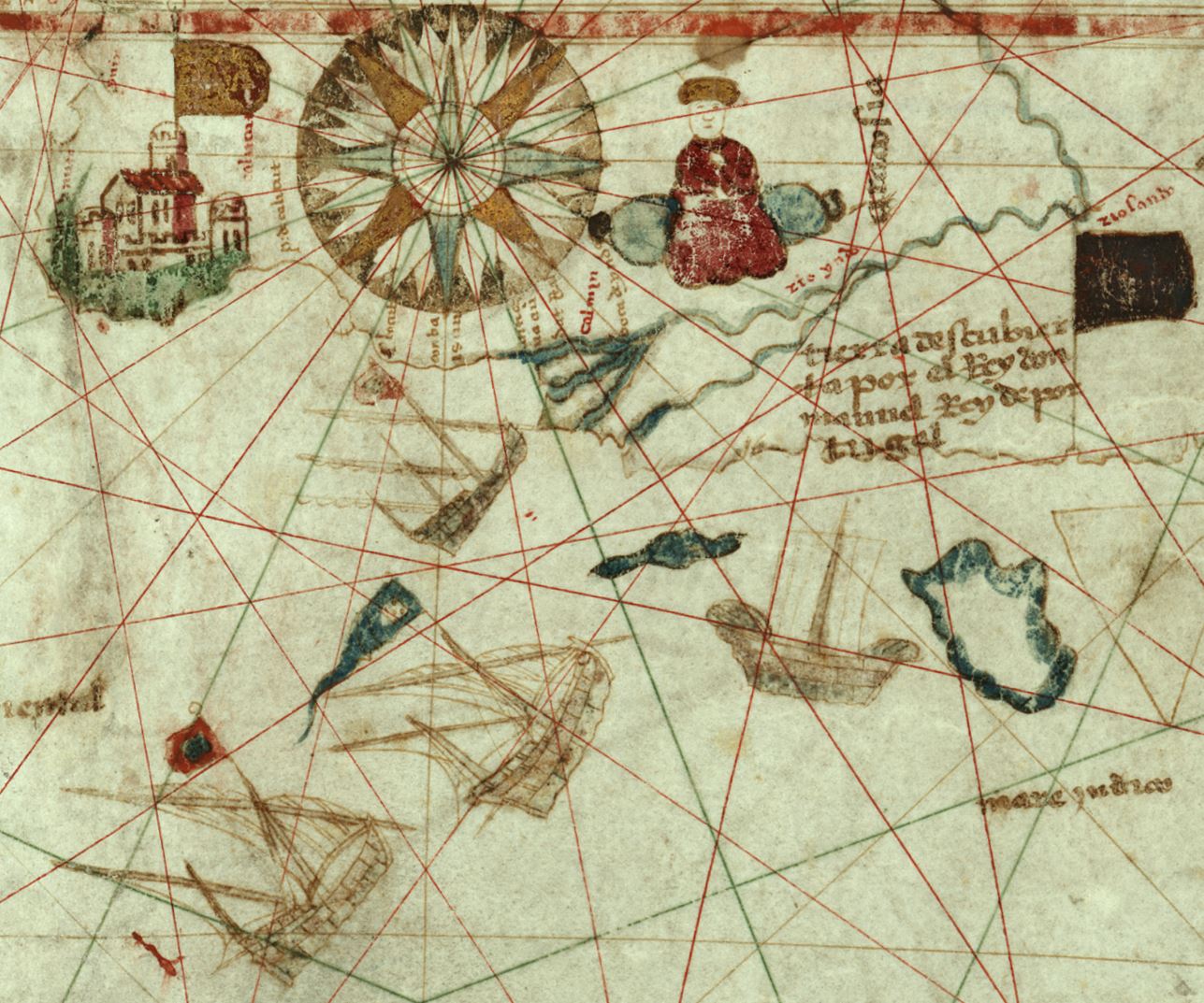
Structurally the object is two charts joined into one. The Old World portion follows the conventions of ordinary Mediterranean portolan charts of the period: the African coastline reflects the most recent Portuguese reconnaissance, with a note near the Cape recording that the coast was reached under King John II of Portugal, a reference to Bartolomeu Dias's voyage of 1487-1488. Asia is drawn only as far as the Arabian Sea, cutting the continent off before China or Japan, with a note crediting King Manuel of Portugal for the coast beyond, a reference to Vasco da Gama's voyage of 1497-1499.
The American portion is drawn at a different, larger scale than the Old World, a discrepancy some historians estimate at roughly 1.4 to 1, which stretches the apparent size of the new discoveries relative to everything else on the sheet. The map supplies two unmarked dot-scales in the margins of its western half, thought to represent intervals of about fifty miles, but nowhere states the coordinate system or projection it uses; a 2010 cartometric study by Luis A. Robles Macias proposed a specific mathematical projection consistent with the Atlantic coastlines and found the chart's American latitudes considerably more accurate under that reading than earlier commentators had judged them by eye.
Chapter 3Saint Christopher over the unmapped isthmus
Where a cartographer with better information would have drawn a coastline, the chart instead places a large framed image of Saint Christopher carrying the infant Christ across a river, positioned...
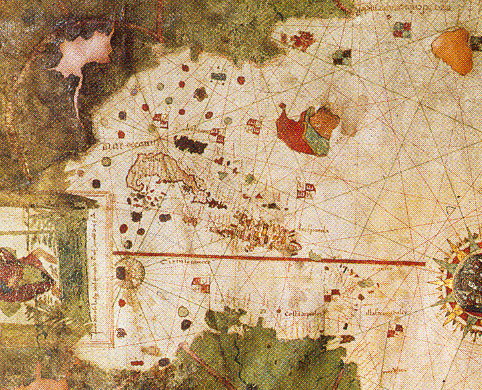
Where a cartographer with better information would have drawn a coastline, the chart instead places a large framed image of Saint Christopher carrying the infant Christ across a river, positioned squarely over the region that would become Central America. Below it sits the signature legend. The pairing is usually read as a visual pun: the saint who carried Christ across the water stands in for Christopher Columbus, who carried Christianity across the Atlantic.
The image also does cartographic work. By covering the isthmus rather than drawing it, de la Cosa avoided having to commit to a continuous coastline joining North and South America, a decision that would have foreclosed the possibility, which Columbus and others still argued for, of an open sea passage through to the Indian Ocean and the Spice Islands. The same evasion appears at the map's eastern edge, where the deliberate cutoff before China and Japan spares the chart from having to take a position on whether the lands Columbus reached were the edge of Asia or something new. Both choices are treated by cartographic historians as considered omissions rather than gaps in knowledge, a chartmaker declining to draw a conclusion the political and geographic argument of the day had not yet settled.
Chapter 4What the Old World half still adds
The Old World portion is easy to treat as filler beside the New World data that gives the chart its fame, but it carries its own information worth reading closely.
The Old World portion is easy to treat as filler beside the New World data that gives the chart its fame, but it carries its own information worth reading closely. Below the Indian peninsula a note credits King Manuel of Portugal with the coast beyond, tying that section of the chart directly to Vasco da Gama's 1497-1499 voyage, which means the Old World half of the sheet was current to within a year or two of the chart's own completion date, not copied wholesale from an older exemplar. Ceylon appears as a large triangular island under the name Trapobana, and two further large islands in the middle of the Indian Ocean, named Zanabar and Madagascoa, are drawn in a form close to their equivalents on Martin Behaim's globe of 1492, evidence of a shared stock of Ptolemaic and early-Renaissance geographic convention that both works were drawing on independently.
The chart's Asia stops at the shores of the Arabian Sea, cutting off before Indochina, China, or Japan. Historians read this as a second version of the same evasion at work over Central America: by declining to draw the Asian mainland any further east, de la Cosa avoided having to take a position on whether Columbus's discoveries were the edge of that same continent or something genuinely new. Both cutoffs, the American isthmus hidden under Saint Christopher and the Asian coast trimmed short, serve the same function, letting the chart carry the live geographic argument of 1500 without forcing an answer to it.
Chapter 5Guanahani, left unmarked
Among the Bahamas, which de la Cosa charts with unusual care and individually names, sits the island of Guanahani, the first land in the Indies that Columbus claimed to have sighted on his first...
Among the Bahamas, which de la Cosa charts with unusual care and individually names, sits the island of Guanahani, the first land in the Indies that Columbus claimed to have sighted on his first voyage. It receives no special graphic treatment on the chart at all, no distinguishing mark, no flag, no cartouche, nothing to set it apart from any of its neighbors. For an island that would become the anchor point of the entire Columbian landfall debate in later centuries, its complete ordinariness here is itself a small piece of evidence: to de la Cosa, sailing the Bahamas in the 1490s and drawing them in 1500, Guanahani was simply one island among the group, not yet the symbolically loaded point of first contact it was later made into.
Chapter 6The latitude problem
Read as a strict grid of longitude and latitude, the chart's longitudes for the Atlantic crossing are close to correct: the apparent longitudinal gap between the Iberian peninsula and Hispaniola...
Read as a strict grid of longitude and latitude, the chart's longitudes for the Atlantic crossing are close to correct: the apparent longitudinal gap between the Iberian peninsula and Hispaniola works out to about 62 degrees against a true value of roughly 59, and Africa sits about 16 degrees from the northeast coast of South America against a true separation of about 17.75, both reasonably tight for the period. Its American latitudes, by the same simple grid reading, are considerably worse. Puerto Rico is drawn sitting on the Tropic of Cancer when it in fact lies about five degrees south of it. Hispaniola is placed at the same latitude as the Canary Islands, though the two differ by roughly eight degrees in reality. Cuba's north coast appears as far north as 36 degrees, some twelve degrees north of its true position.
Two things complicate any simple verdict of error. First, Columbus made comparable mistakes independently: his March 1493 letter describing his own return voyage claims Hispaniola lies 26 degrees from the equator, and he repeated a similar figure in a 1494 letter to the Crown, when the island in fact sits between about 17.5 and 20 degrees north, suggesting these latitude errors were common currency among Spanish navigators of the moment rather than a fault unique to this chart. Second, a 2010 cartometric study by Luis A. Robles Macias argued that reading the chart against a specific, non-obvious projection rather than a simple rectangular grid produces considerably more accurate latitudes across both the Old and New World, with errors generally under two degrees; if that projection is the right one to apply, most of the apparent latitude error is an artifact of reading the chart the wrong way rather than evidence de la Cosa measured badly. The two findings sit uneasily together and this record does not adjudicate between them; both are reported because a reader doing diligence on the chart's technical accuracy needs both halves of the argument.
Chapter 7The authorship and dating dispute
The legend is unambiguous about who made the chart and when.
The legend is unambiguous about who made the chart and when. Whether the surviving sheet is what it claims to be is a genuine, long-running argument among cartographic historians, not a settled footnote.
The challenge was first formulated by George E. Nunn in a 1934 monograph, which argued that Cuba could not have been circumnavigated before 1509, so de la Cosa could not have known in 1500 that it was an island, which the chart nonetheless shows correctly. Nunn's argument has been contested since: Ricardo Cerezo Martinez and others point out that Pietro Martire d'Anghiera, writing in 1501, already reported that many claimed to have sailed around Cuba, which undercuts Nunn's chronology. The counter-argument from the other direction is that the chart omits events that had happened by the time it was supposedly finished, most pointedly de la Cosa's own third voyage of 1501-1502, which reached the Gulf of Uraba and the Darien coast and left no trace on the map at all; if the sheet were retouched as late as 1508-1509, that omission is harder to explain.
A separate and more widely held position does not dispute the 1500 date so much as the hand: that the surviving sheet is a copy of a lost original rather than de la Cosa's own autograph work. The chief evidence is the state of the New World place names, many of which are illegible in a way consistent with a copyist unable to make out the original author's handwriting rather than with damage or fading. The Spanish military historian Hugo O'Donnell pushed this further, arguing that de la Cosa's own contribution may have amounted to no more than a working sketch, later completed and elaborated by a different, unnamed cartographer.
Material science has weighed in without fully resolving the question. In 1987 the Documentation Laboratory of the Museo del Prado analyzed the chart's pigments and found them compatible with an execution date of 1500, with no signs of later repainting. That result supports an early date for the physical object itself, but it cannot distinguish a single 1500 autograph from a faithful, contemporaneous copy made from the same period materials, so it narrows the dispute without closing it. A 2017 study by Joaquim Alves Gaspar approaches the same problem from the institutional side, asking whether the chart represents the first known Spanish padron real, the official royal master chart from which authorized copies were struck, or instead the last of an older, informal charting tradition before the padron real system was established; his framing treats the sheet's early depiction of the equator and the Tropic of Cancer, on a chart of this date, as evidence that observed astronomical latitude had already begun entering Spanish nautical cartography.
Chapter 8Cuba, and what a correct island proves
The dispute over Cuba is worth setting out on its own because it is the single most-argued detail on the chart.
The dispute over Cuba is worth setting out on its own because it is the single most-argued detail on the chart. De la Cosa draws Cuba as an elongated island, pinched at two points, with numerous bays and a curved western tip enclosing a gulf scattered with small islands, an outline cartographic historians consider reasonably accurate for the period. The difficulty is that Columbus himself had made every member of his second voyage, de la Cosa included, swear in June 1494 that Cuba was not an island but a peninsula of the Asian mainland. A chart correctly showing it as an island in 1500, made by a man who had sworn otherwise six years earlier, is either evidence the chart postdates that oath by years, or evidence that de la Cosa simply knew better than the oath he had been made to take.
Historians divide on which reading is correct. Those who doubt de la Cosa could have known Cuba was insular in 1500 point to the fact that the definitive circumnavigation of the island is credited to Sebastian de Ocampo's voyage of 1508-1509. Those on the other side argue that partial Castilian voyages had already sailed around portions of Cuba's coast well before Ocampo's confirming circumnavigation, and that de la Cosa, present in the Caribbean through the 1490s, had ample opportunity to learn the truth independent of any single official voyage. Neither side has produced a document that ends the argument, and this record does not resolve it either; the honest description is that the chart's Cuba is the strongest single piece of evidence on both sides of the dating dispute, not proof for either one.
Chapter 9What the chart says about America, briefly, against the corpus
Set beside the corpus's other early world maps, this chart's place is specific and narrow.
Set beside the corpus's other early world maps, this chart's place is specific and narrow. It predates the Cantino planisphere by two years and depicts markedly less of the American coastline, without that chart's more complete Portuguese data on Brazil. It predates the Waldseemuller world map of 1507 by seven years and, unlike Waldseemuller, does not draw the New World as a separate continent at all, let alone name it America; de la Cosa's chart is a full generation older than the name it eventually made possible. It has no genealogical relationship to the Piri Reis map of 1513, an Ottoman compilation which claims Columbus's own charts among its twenty-odd sources, though the claim illustrates how fast Spanish Atlantic data of the kind on this chart could travel once it existed.
What distinguishes this chart from all of them is that its maker was there. Alonso de Ojeda and Amerigo Vespucci sailed the northern coast of South America with de la Cosa in 1499-1500, and de la Cosa had crossed the Atlantic with Columbus twice before that. No other surviving map of the Americas from this early was made, even in part, by someone who had navigated the coasts it depicts. That is the basis for the claim, made across the literature on this object, that it is the earliest surviving European map to show any part of the Americas from direct exploration rather than from theory or secondhand report; the caveat attached by every serious source that makes the claim is the dating dispute itself, since a map retouched after the fact draws on more than one voyage's worth of direct knowledge, and to that extent stops being a single eyewitness snapshot.
Chapter 10Juan de la Cosa before the chart
De la Cosa was born in Santona, on the Cantabrian coast, at some point in the mid-fifteenth century; no source consulted for this record gives a firmly documented birth year, and estimates in the...
De la Cosa was born in Santona, on the Cantabrian coast, at some point in the mid-fifteenth century; no source consulted for this record gives a firmly documented birth year, and estimates in the literature range from about 1449 to 1460. He later lived much of his working life out of the port of Santa Maria, near Cadiz, the port his chart names as the place of its making.
His documented role in Columbus's first voyage of 1492 was not that of an ordinary sailor. He owned and was master of the Santa Maria, Columbus's flagship, while Columbus himself held the overall command. The ship wrecked off the coast of present-day Haiti on the night of 24-25 December 1492. Columbus's own account of the wreck accused de la Cosa of abandoning the sinking ship rather than helping to save it, a charge de la Cosa disputed; he was compensated for the loss of the vessel in 1494. He sailed again on Columbus's second voyage, 1493-1496.
Chapter 11The 1499-1500 voyage that made the chart possible
In 1499 de la Cosa joined Alonso de Ojeda as chief pilot on an independent expedition to South America, in which Amerigo Vespucci also took part.
In 1499 de la Cosa joined Alonso de Ojeda as chief pilot on an independent expedition to South America, in which Amerigo Vespucci also took part. They sailed in May 1499 and charted a substantial stretch of the Atlantic coast of South America, from roughly the Essequibo river to Cape de la Vela. The return date is itself disputed: the traditional account gives June 1500, but the historian Demetrio Ramos has argued for a considerably earlier return, around November 1499. The chart is generally thought to have been drawn in the summer or autumn of 1500, after de la Cosa's return and before he sailed again, this time with Rodrigo de Bastidas, on an expedition some sources date to late 1500 and others to mid-1501.
Its evident quality and rich decoration lead historians to conclude it was made on commission for someone of real standing at court, quite possibly Bishop Juan Rodriguez de Fonseca, who administered Spain's American affairs on behalf of the Crown throughout this period. One direct piece of testimony survives from a pilot named Juan de Jerez, who stated in a 1513 legal deposition connected to the Columbus lawsuits that he had personally seen the chart de la Cosa made on that 1499-1500 voyage and the coastline it recorded, evidence that de la Cosa was carrying at least a working sketch of the coast home with him from the voyage itself.
Chapter 12From the Crown to three centuries of silence
The next documented moment comes in 1503, when de la Cosa presented two sea charts of the Indies to Ferdinand and Isabella at Segovia.
The next documented moment comes in 1503, when de la Cosa presented two sea charts of the Indies to Ferdinand and Isabella at Segovia. Whether either of those two charts was this exact sheet, or a later, updated version of the same underlying chart, is not established in the sources consulted for this record; the presentation is documented, the identity of the object presented is not certain.
The two charts are then thought to have passed into the custody of Bishop Fonseca, where the historian and papal chronicler Pedro Martir de Angleria examined them in Fonseca's office. Writing on 4 December 1514, four years after de la Cosa's death, Martir recorded having seen a solid globe of the world and several sea charts there, among them work by de la Cosa, whom he names, alongside charts attributed to the Portuguese with Vespucci's involvement and one begun by Columbus and continued by his brother Bartolome. It is the earliest outside assessment of de la Cosa's cartographic work to survive, and it treats his charts as being kept among the most valued in Fonseca's collection.
After 1514, the trail goes dark. No document places the chart anywhere for roughly three centuries. It resurfaces already in commercial hands, in a shop in Paris, bought by the French naturalist and diplomat Baron Charles Athanase Walckenaer early in 1832. How it left Spain, whether through an ordinary sale, an inheritance passed down without record, or an outright theft from a Spanish archive, is not documented, and this record does not guess at it. A 2024 article by Luisa Martin-Meras Verdejo, published in the Revista de Historia Naval, argues for a specific theft hypothesis covering this gap, framed by the article's own title as the first of two thefts in the chart's history, the second being its wartime departure from Spain in 1936. That is a recent scholarly proposal, not yet a settled consensus, and this record flags it as such.
Chapter 13Humboldt, the auction, and the return to Spain
In the spring of 1832, shortly after acquiring it, Walckenaer showed the chart to friends visiting Paris, among them the German naturalist Alexander von Humboldt, who recognized its importance and...
In the spring of 1832, shortly after acquiring it, Walckenaer showed the chart to friends visiting Paris, among them the German naturalist Alexander von Humboldt, who recognized its importance and was the first to bring it to scholarly attention. The Spanish scholar Ramon de la Sagra published the chart's western, American portion in 1837, and the Portuguese scholar and diplomat the Viscount of Santarem reproduced its African portion in 1842. For the rest of Walckenaer's life the chart stayed in his private collection in Paris.
Walckenaer died in 1852 and his library went to auction. Ramon de la Sagra alerted the Spanish Ministry of Marine to the sale and to the chart's importance, and the Ministry authorized La Sagra to bid on Spain's behalf. Spain won the chart for 4,321 francs. Whether that figure was a hammer price or an all-in price, and which auction house conducted the Walckenaer estate sale, are not specified in the sources consulted for this record. The chart entered the Museo Naval in Madrid in 1853 and went on display in the museum's Sala de Descubrimientos, where it has remained the museum's central exhibit ever since, with one significant interruption.
Chapter 14The wartime absence, 1936-1939
That interruption came during the Spanish Civil War.
That interruption came during the Spanish Civil War. In November 1936 the chart was evacuated from Madrid to Valencia along with the rest of what came to be called Spain's Tesoro Artistico, following the Republican government as it relocated. From Valencia the collection moved to Barcelona, then to Girona province, and in February 1939, as the Republic collapsed, across the border to the headquarters of the League of Nations in Geneva. When the war ended, the League handed the Tesoro Artistico, this chart among it, over to Franco's government, and the chart returned to the Museo Naval in Madrid on 3 June 1939.
The episode is the subject of Luisa Martin-Meras Verdejo's 2024 study, which treats it as the second of the two departures from Spain named in the article's title, the first being the chart's undocumented exit from Spain before its reappearance in Paris in 1832. Whatever happened to the chart during its years abroad in the 1930s, it survived intact and came home; the surrounding record of exactly how it was held and transferred between 1936 and 1939, beyond the outline above, was not available in the sources consulted for this record.
Chapter 15Display, facsimile, and the original's present state
The chart has never been restored. Its condition is generally described as good, with some flaking losses near the top of the sheet and damage attributed to an unspecified fire at some point in its...
The chart has never been restored. Its condition is generally described as good, with some flaking losses near the top of the sheet and damage attributed to an unspecified fire at some point in its history. Several facsimile editions have been produced, the first in 1892, timed to the fourth centenary of Columbus's landfall, and the most recent in 1992, for the fifth centenary. Between those anniversaries, a handmade copy made by the museum's own cartographer, Juan Pedro Suarez Davila, stood in for the original on public display from 1988 to 1992, while the original itself was kept off view.
In 2021 the Factum Foundation digitized the chart using a Lucida 3D scanner combined with composite photography, capturing both its surface relief and its color, and produced a facsimile using elevated-print technology for display at the Spanish Gallery in Bishop Auckland. Reporting connected to that project has suggested the Museo Naval may eventually substitute a facsimile for the fragile original on permanent display, echoing the 1988-1992 precedent; whether and when that happens is a live, unresolved question rather than a settled fact, and belongs among the open questions below rather than in the record of what has already occurred.
Chapter 16Attention in three waves
Scholarly attention to the chart has arrived in three concentrated bursts rather than as a steady stream, and each is tied to an anniversary or a rediscovery rather than to a change in the object...
Scholarly attention to the chart has arrived in three concentrated bursts rather than as a steady stream, and each is tied to an anniversary or a rediscovery rather than to a change in the object itself. The first wave followed its 1832 resurfacing, when Humboldt, Ramon de la Sagra, and the Viscount of Santarem gave it its first scholarly description and reproduction through the 1830s. The second followed the 1892 fourth centenary of Columbus's landfall, which produced the chart's first facsimile edition and an accompanying study by the researcher A. Vascano. The third gathered around the 1992 fifth centenary, which produced the most recent facsimile and much of the technical and cartometric literature, including Alves Gaspar's later Padron Real argument, that this record draws on. Reading the historiography this way explains an otherwise odd feature of the literature: long stretches with almost nothing published, interrupted by short periods of intense, overlapping scholarship, all clustered around round-number Columbus anniversaries rather than around new archival finds.
Chapter 17Turbaco
De la Cosa's career after the chart continued to be spent at sea.
De la Cosa's career after the chart continued to be spent at sea. New World Encyclopedia's account, the only source found for this specific voyage, places him in command of an expedition to the Pearl Islands and the Gulf of Uraba around 1504-1506; this record flags that detail as thinly sourced rather than independently confirmed, since no second source corroborating it was found.
His last voyage is much better documented. In 1509 he sailed once more with Alonso de Ojeda, departing Santo Domingo on 10 November 1509 with roughly two hundred colonists aboard three ships, bound for the coast of present-day Colombia. On arrival, de la Cosa advised against landing at Cartagena and argued for the more peaceable coast of the Gulf of Uraba instead, on the grounds that the local population used poisoned arrows extensively and effectively. Ojeda overruled him. The party pushed inland to the village of Turbaco, roughly twenty kilometers from Cartagena, where they were attacked by the Indigenous inhabitants. De la Cosa was struck by poisoned arrows and died of the wounds; most surviving accounts agree the attack was a rout for the Spanish party and that de la Cosa did not survive it. Ojeda escaped and reached a passing expedition, which returned with him to Turbaco to retaliate. De la Cosa died on 28 February 1510. This record found no documented earlier ambush at Turbaco that de la Cosa survived before this fatal one; every source consulted describes a single engagement there, in late 1509 or very early 1510, that killed him.
Chapter 18What is unresolved
The largest unresolved question is the oldest one on this record: whether the sheet in the Museo Naval is de la Cosa's own 1500 work, a faithful copy of it made later, or, as Hugo O'Donnell has...
The largest unresolved question is the oldest one on this record: whether the sheet in the Museo Naval is de la Cosa's own 1500 work, a faithful copy of it made later, or, as Hugo O'Donnell has proposed, a sketch by de la Cosa finished by another hand. A century of argument over Cuba's insular coastline and the state of the chart's toponyms has not settled it, and the 1987 pigment analysis, while informative, addresses only the materials, not the authorship of the drawing itself.
Underneath that larger dispute sit several smaller, equally open gaps: the roughly three centuries between Pedro Martir's 1514 sighting and Walckenaer's 1832 purchase, across which no document places the chart anywhere; the exact circumstances of its departure from Spain that Martin-Meras's 2024 study frames as a theft; and the precise handling of the chart during its 1936-1939 absence from Spain, beyond the broad outline of Valencia, Barcelona, Girona, and Geneva. None of these gaps should be filled with a guess, and none are.
The artist
Juan de la Cosa
Juan de la Cosa is known almost entirely through the record of what he did rather than what he wrote or said about himself. No personal correspondence, journal, or first-person account by him survives. What is documented comes from ships' logs, legal depositions taken after his death, a handful of contemporary chroniclers who mention him, and the chart itself, which is both his single greatest surviving work and, in the eyes of a substantial part of the scholarship on it, possibly not entirely his own unaided hand. That tension, a man mostly known through his actions at sea and a chart whose authorship is itself disputed, is the right way to read every fact below.
Related works
| Work | Relation | Where it is |
|---|---|---|
| Cantino planisphere Unknown Portuguese chartmaker | The next-earliest surviving European map to depict the Americas, made two years after this chart and drawing on more complete Portuguese data for the Brazilian coast Already catalogued in this collection; see that record for its own theft and recovery history, unrelated to this chart's. | Biblioteca Estense Universitaria, Modena |
| Universalis Cosmographia (the Waldseemuller 1507 world map) Martin Waldseemuller | Made seven years after this chart; the first map to use the name America and the first to draw the New World as a separate continent, a step this chart's maker did not take Already catalogued in this collection. | Library of Congress, Washington DC |
| The Piri Reis Map of 1513 Piri Reis | An Ottoman compilation chart whose own legend claims to draw on some twenty source maps, including a chart said to have belonged to Columbus; illustrates how quickly Spanish Atlantic charting data of the kind on this sheet could circulate beyond Spain, without any direct link to this specific chart Already catalogued in this collection. | Topkapi Palace Museum, Istanbul |
| Cabot's map of the North American coast (lost) John Cabot, or a copy made for the Spanish Crown | Believed to be the source for the five English flags de la Cosa placed on this chart's North American coastline Sent to Ferdinand and Isabella by the Castilian ambassador in London, Pedro de Ayala; no copy is known to survive. | Untraced; presumed lost |
Open questions
- Is the surviving sheet Juan de la Cosa's own 1500 original, a later copy of a lost original, or a de la Cosa sketch completed by another cartographer, as Hugo O'Donnell has argued? A century of argument over Cuba's coastline and the state of the New World toponyms has not settled it.
- Does the Museo Naval hold a modern accession or inventory number for the chart internally? None is quoted in any source consulted for this record.
- How did the chart leave Spain and reach a Paris shop before Baron Walckenaer's 1832 purchase? Three centuries pass between Pedro Martir's 1514 sighting and the 1832 resurfacing with no document placing the chart anywhere. Luisa Martin-Meras's 2024 article proposes a theft; whether other historians accept that thesis is not yet established.
- What exactly happened to the chart between its November 1936 evacuation from Madrid and its 3 June 1939 return, beyond the broad outline of Valencia, Barcelona, Girona province, and Geneva?
- Did the 1499-1500 Ojeda-Vespucci expedition, on which de la Cosa served as chief pilot, return in November 1499 or June 1500? The chart's completion window depends in part on which date is correct.
- Did Rodrigo de Bastidas's expedition, de la Cosa's next voyage after the chart, depart in late 1500 or mid-1501? Sources disagree, and the usual dating of the chart to summer or autumn 1500 assumes the earlier figure.
- Has the Museo Naval acted on reported plans to substitute the Factum Foundation's 2021 facsimile for the original on permanent display, as it did between 1988 and 1992 with a different handmade copy? No source consulted confirms this has happened.
Questions about this object
What is Carta Universal de Juan de la Cosa?
Carta Universal de Juan de la Cosa is a map, dated 1500, per its own legend; a substantial minority of cartographic historians argue the surviving sheet is a copy or composite completed after 1500, in some readings as late as 1508-1509 (see narrative). Medium: Ink and watercolor pigment on two joined sheets of parchment (calfskin), sewn onto a canvas backing.
Who made Carta Universal de Juan de la Cosa, and is the attribution settled?
The attribution to Juan de la Cosa is recorded here as disputed. The chart's own legend claims sole authorship by Juan de la Cosa, made at the port of Santa Maria in 1500. Cartographic historians dispute whether the surviving sheet is that 1500 original, a later copy of a lost original, or, on one scholar's reading, a de la Cosa sketch completed and enriched by another cartographer. A 1987 pigment analysis found materials consistent with a 1500 execution and no evidence of later repainting, which supports an early date for the physical object but does not by itself settle whether a single hand or several produced the composition. See Narrative, 'The authorship and dating dispute.'
Where is Carta Universal de Juan de la Cosa now?
Museo Naval, Madrid. Inventory number Not documented in any source consulted for this record. The Museo Naval's own published material identifies the chart by title (Carta Universal de Juan de la Cosa) and gallery location, not by a quoted registry or accession number, and no scholarly citation found for this record gives one either. If a modern internal inventory number exists, it is not publicly quoted; state this plainly rather than guessing at a number.. Last confirmed 18 September 2026. Purchased by the Spanish Ministry of Marine at the 1852-1853 estate sale of Baron Walckenaer's library and placed on exhibition in the museum's Sala de Descubrimientos in 1853, where it has remained the museum's signature holding ever since (with one wartime absence, 1936-1939).
What has Carta Universal de Juan de la Cosa sold for?
Hammer 4,321 francs; with premium, Not specified; sources do not distinguish a hammer price from an all-in price for this sale. Estate sale of the library of Baron Charles Athanase Walckenaer, Paris (the specific auction house is not named in the sources consulted), 1852-1853.
What is still unknown about Carta Universal de Juan de la Cosa?
Is the surviving sheet Juan de la Cosa's own 1500 original, a later copy of a lost original, or a de la Cosa sketch completed by another cartographer, as Hugo O'Donnell has argued? A century of argument over Cuba's coastline and the state of the New World toponyms has not settled it.
Sources
- 1Wikipedia (Spanish), 'Mapa de Juan de la Cosa', a featured article (Articulo bueno) consolidating and citing Martin-Meras Verdejo (2000), Cerezo Martinez (1989, 1993, 1994), Nunn (1934), Roukema (1959), Davies (1976), Alvarez (2003), Manzano Manzano (1988), Verlinden and Perez Embid (2006), Hugo O'Donnell, Elkhadem et al. (1992), Rivero Dominguez (2003), and Martin-Meras Verdejo's 2024 article on the chart's two departures from Spain. Flagged for replacement with the primary journal articles and Martin-Meras Verdejo's monograph directly. es.wikipedia.org/wiki/...
- 2Wikipedia (English), 'Map of Juan de la Cosa'. Tertiary source, flagged for replacement with primary scholarship. en.wikipedia.org/wiki/...
- 3Wikipedia (English), 'Juan de la Cosa'. Tertiary source, flagged for replacement with a scholarly biography. en.wikipedia.org/wiki/...
- 4Factum Foundation, 'The Map of Juan de la Cosa', on the 2021 digitisation and facsimile made for the Spanish Gallery, Bishop Auckland. factumfoundation.org/our-projects/...
- 5Wikipedia (English), 'Naval Museum of Madrid'. Tertiary source, cited only for the chart's status as the museum's signature permanent-display holding. en.wikipedia.org/wiki/...
- 6Alida C. Metcalf, 'Color Plate 4: Juan de la Cosa, Carta Universal, 1500', Mapping an Atlantic World, Rice University. acm5.blogs.rice.edu/color-plate-4
- 7Historia del Nuevo Mundo, 'Juan de la Cosa, first cartographer of America'. historiadelnuevomundo.com/en/...
- 8Historia del Nuevo Mundo, 'Ojeda leaves for Uraba, the governorate that would never govern'. historiadelnuevomundo.com/en/...
- 9Wikipedia (English), 'Alonso de Ojeda'. Tertiary source, cited for the chronology of Ojeda's voyages with de la Cosa. en.wikipedia.org/wiki/...
- 10New World Encyclopedia, 'Juan de la Cosa'. Tertiary source, the only source found for the 1504-1506 Pearl Islands and Gulf of Uraba expedition; flagged as thinly corroborated. newworldencyclopedia.org/entry/...
- 11Joaquim Alves Gaspar, 'The Planisphere of Juan de la Cosa (1500): The First Padron Real or the Last of Its Kind?', Terrae Incognitae 49, no. 1 (2017): 68-88. Consulted via publisher abstract and secondary summary; full text was not accessible (paywalled). tandfonline.com/doi/...
- 12James L. Smith, 'Europe's confused transmutation: the realignment of moral cartography in Juan de la Cosa's Mappa Mundi (1500)', European Review of History: Revue europeenne d'histoire 21, no. 6 (2014). Consulted via publisher abstract and secondary summary; full text was not accessible (paywalled). tandfonline.com/doi/...
- 13Luis A. Robles Macias, 'Juan de la Cosa's Projection: A Fresh Analysis of the Earliest Preserved Map of the Americas', Coordinates, Series A, no. 9 (2010). Consulted via secondary summary; full text was not directly accessible. academia.edu/737652/...
Last verified 18 September 2026 · Published 18 September 2026
Change log
18 September 2026 - Record created at the house standard: researched narrative, technical evidence, maker dossier, graded provenance chain, prices with hammer and premium separated, related works, open questions and sources.