Cantino planisphere
Unknown Portuguese chartmaker · 1502
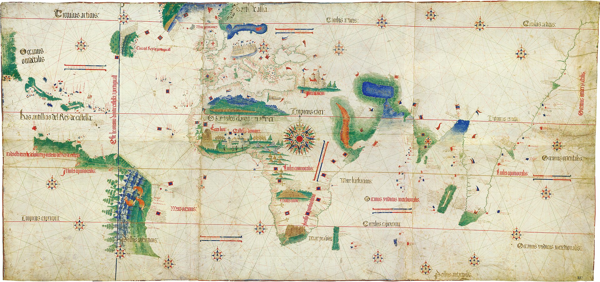
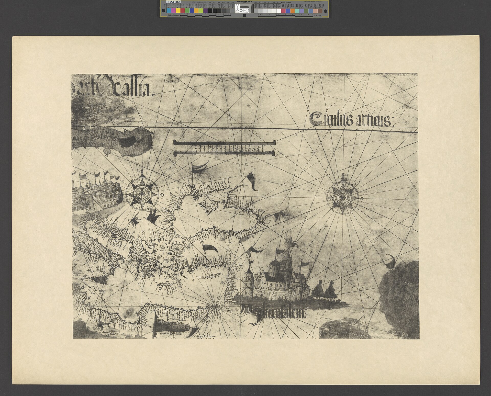
The object described in this record, photographed in the Biblioteca Estense Universitaria at Modena. There is only one Cantino planisphere, so no other copy exists to be confused with it; the risk in this case is the facsimiles, which are labelled as such below.
| Artist | Unknown Portuguese chartmaker |
|---|---|
| Date | 1502 |
| Medium | Ink, pigment and gold on parchment, six skins joined |
| Dimensions | About 105 x 220 cm |
| Where it is now | Biblioteca Estense Universitaria, Modenalast confirmed 17 September 2026 |
| Inventory number | C.G.A.2 (ark:/65666/v1/13655) |
| Attribution | UnknownThe chart is unsigned and its maker has never been identified. Full note |
| Object type | Map |
| Period | Portuguese, early sixteenth century |
| Cases | Has a provenance gap |
| Inscriptions | Place names along the coasts in black and red according to importance. The top margin, which Harrisse believed carried a title in large gothic letters, was cut away and destroyed before 1859 |
| Owners on record | 7 links5 documented, 1 disputed, 1 unknown |
| Sources | 7 cited |
About this record Last verified 17 September 2026 · 7 sources cited · Change log
On this page 10 sections
ContentsClose
A Portuguese world chart of 1502 on six joined skins of parchment, about 105 by 220 cm, the earliest surviving map to show the Brazilian and Caribbean coasts and to mark the Tordesillas line. It is named not for the man who drew it, who is unknown, but for Alberto Cantino, the agent of Ercole I d'Este who had it made in Lisbon and sent it to Ferrara. His covering letter of 19 November 1502 survives and gives the only price this object has ever had: twelve gold ducats, by contract.
What makes it a provenance record rather than a cartography lecture is what happened afterwards. The chart went with the Este library to Modena when the family lost Ferrara. At some point before 1859 an owner cut off its top margin, probably removing its title, and pasted the map onto the folds of a screen. In the upheaval of 1859 the ducal palace was invaded and the map stolen. A few years later Giuseppe Boni, the librarian of the Biblioteca Estense, walking down the Via Farini in Modena, saw it doing duty as a screen in the shop of a pork butcher named Giusti. He bought it, lifted the vellum off the screen, and gave it to the library in 1870.
It has been in Modena ever since, shelfmark C.G.A.2. There is one of it. The version risk in this record is not another copy but the facsimiles, which have circulated since 1906 and are routinely reproduced as though they were the object.
Provenance
Each link is graded. Documented: a cited source supports it. Disputed: the identification is argued but not established. Unknown: no owner for that span, and the gap is not smoothed into a narrative. The grades in the glossary.
- 1502 - 1502Alberto Cantino, agent of Ercole I d'Este at Lisbondocumented
From Cantino's own letter to the Duke, written at Rome on 19 November 1502, one of five of his letters preserved in the Archivio di Stato di Modena. Whether its removal from Portugal breached a secrecy policy is an interpretation, held by the holding library, and not stated in the letter.12
- 1502 - the 1590sThe House of Este, ducal archives, Ferraradocumented
Acquired by Ercole I d'Este in 1502, per the holding library's provenance note.12
- the 1590s - 1859The House of Este, Modenadocumented
Harrisse gives the year as 1592 and attributes the transfer to Clement VIII dispossessing Cesare d'Este. The devolution of Ferrara is normally dated later in that decade, and this record does not substitute another year without a source.2
- before 1859 - 1859An unnamed private possessordisputed
Harrisse calls this person the last possessor and does not name them, and does not explain how a chart in the ducal collections came to be made into furniture. The sequence he gives has the mutilation happening before the theft.2
- 1859 - about 1868Not establishedunknown
No record of who took it or where it was between the theft and its appearance in a shop.
- about 1868 - 1870Giuseppe Boni, librarian of the Biblioteca Estensedocumented
Harrisse's account, written within a few decades of the event. He does not give a year, and he does not say what Boni paid.2
- 1870 - presentBiblioteca Estense Universitaria, Modenadocumented
The library's own note reads: gift of Giuseppe Boni (1870), but already in the old Este collection. It returned as a donation because it had been bought back on the open market rather than recovered as stolen property.12
Prices realised
This chart has never been at auction and no valuation for it has been published. Only two sums are attached to it in any source: twelve gold ducats, the contract cost of having it made in Portugal in 1502, and twenty narrow ducats of three libre each, which is not a price at all but an advance paid to Alberto Cantino at Genoa by Francesco Cataneo. The amount Giuseppe Boni paid the butcher in the Via Farini to get it back is not recorded. There is no hammer price and no buyer's premium anywhere in this object's history.
Technical evidence
| Attribution note | The chart is unsigned and its maker has never been identified. It is named for Alberto Cantino, the Este agent who commissioned it in Lisbon and delivered it to Ferrara, not for the hand that drew it. It is understood to derive from the Portuguese royal pattern chart, the padrao real, which does not survive. |
|---|---|
| Support | Parchment: six skins joined. Catalogued by the holding library as one sheet.13 |
| Dimensions | About 105 x 220 cm overall, per the facsimile produced with the holding library.3 |
| Condition | The top margin was cut away and discarded by a nineteenth-century owner, taking with it what Harrisse believed was a title in large gothic letters; the tail of one letter was still visible in his day.2 |
| Place and date | Lisbon, 1502. Delivered by way of Genoa; Cantino's covering letter is written from Rome on 19 November 1502.12 |
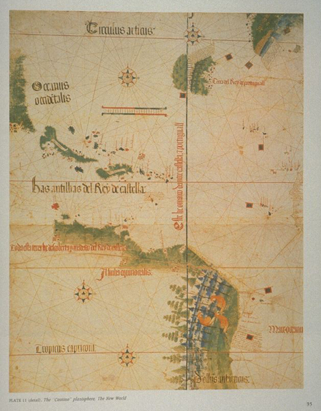
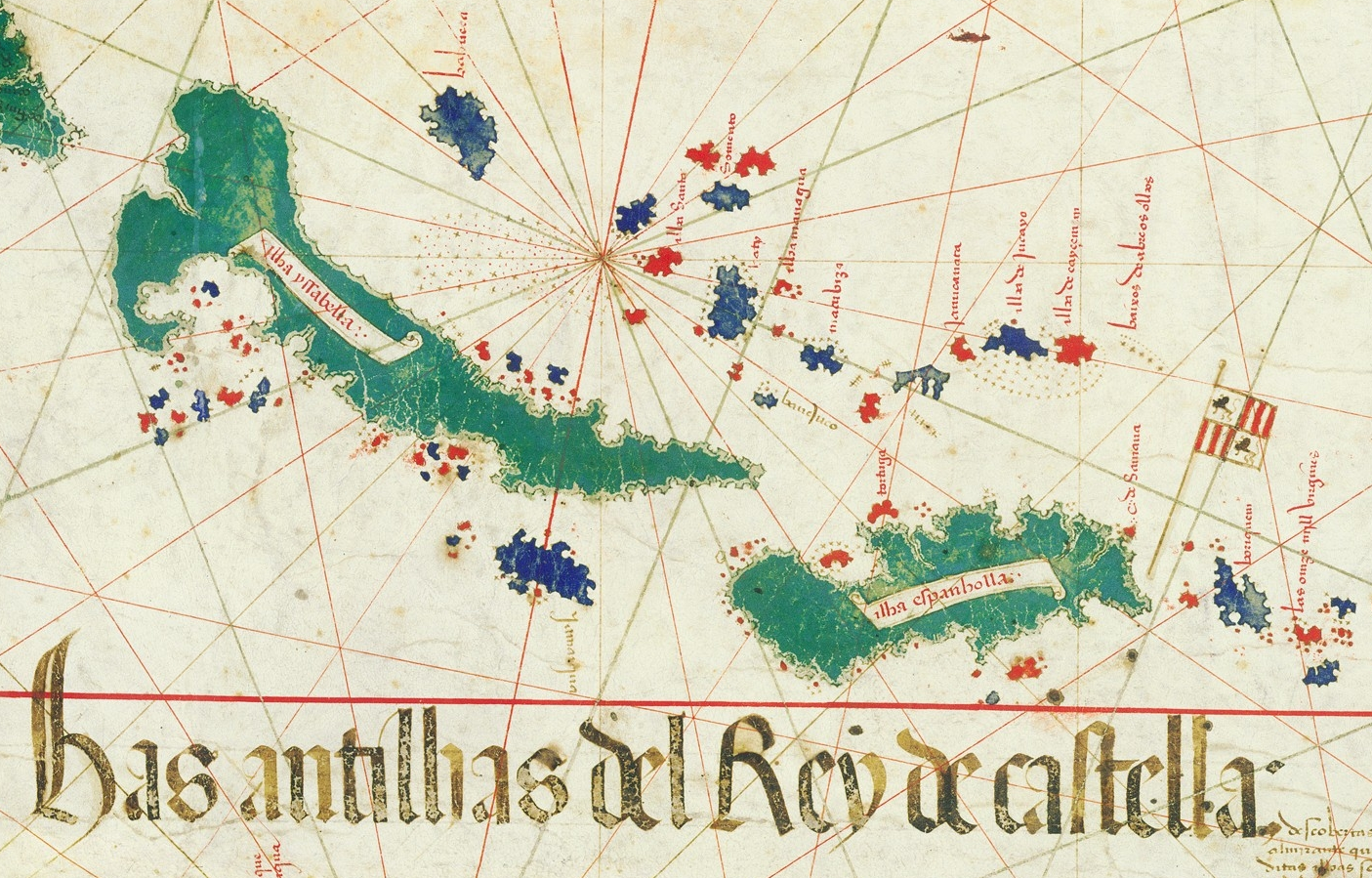
| Content | Caribbean and Brazilian coasts; the raya of the Treaty of Tordesillas; place names in black and red according to importance, in the nautical convention.1 |
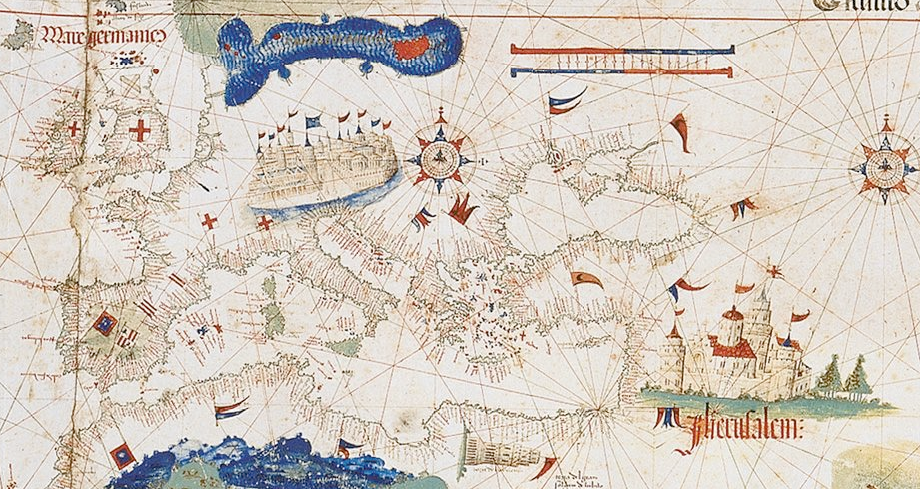
| Decoration | Gold heightening, and interior scenes from medieval legend and scripture: the kingdom of Prester John, the Tower of Babel, the flight from Egypt with the Red Sea parted.13 |
| Geometry | Cartometric analysis finds the geometry fully explained by the cartographic methods of the period. The African coast is a mosaic of regional charts on the plate carree projection, each at its own scale and orientation.45 |
| Shelfmark | Biblioteca Estense Universitaria, Modena, C.G.A.2. Persistent identifier ark:/65666/v1/13655.1 |
Images
The record in full
Chapter 1Six skins joined, and a title somebody cut off
The chart is drawn and illuminated on parchment: six skins joined, measuring about 105 by 220 cm overall.
The chart is drawn and illuminated on parchment: six skins joined, measuring about 105 by 220 cm overall. The Biblioteca Estense Universitaria catalogues it as one sheet, shelfmark C.G.A.2, material parchment, place of production Lisbon, date 1502.
The top margin is missing. Henry Harrisse, who examined the chart in the nineteenth century, recorded that a later owner cut it away and threw it out, and that the margin doubtless carried a title in large gothic letters, of which the tail end of one letter was still visible in his day. That is the physical condition of the object: a world map of 1502 with its own title trimmed off by the man who wanted it to fit a piece of furniture.
Chapter 2A duke's agent, twelve gold ducats, and a letter that survives
Alberto Cantino was in Lisbon as an agent of Ercole I d'Este, Duke of Ferrara.
Alberto Cantino was in Lisbon as an agent of Ercole I d'Este, Duke of Ferrara. Five of his letters to the Duke survive in the Archivio di Stato di Modena, among the papers of the Este ducal chancery, written between 7 June 1501 and 19 November 1502. In them he reports on Portuguese political and economic affairs. In the last of them, written from Rome, he reports that he has obtained a map carrying the most recent discoveries.
Harrisse printed a translation of that letter, and its detail is the reason this record can be precise about money. Cantino tells the Duke that he has left the chart at Genoa in the hands of Francesco Cataneo, who has paid him twenty narrow ducats, that is, ducats of three libre each. Then the sentence that matters: 'In truth, the map cost me in Portugal, by contract, twelve gold ducats; but being hard pressed, and not knowing whom to ask, I was constrained to accept this sum.' He signs it at Rome, 19 November 1502.
So there are two figures and they are not the same kind of figure. Twelve gold ducats is what the chart cost to have made in Portugal, under contract. Twenty narrow ducats is what a Genoese intermediary advanced to Cantino, who was short of cash. Neither is a market price for the object, and the first is a commissioning cost, not a purchase.
Chapter 3Whether it was smuggled is the part everyone repeats and nobody documents
The holding library states the traditional account plainly: despite the prohibitions on taking maps recording the most up-to-date geographical discoveries outside Portuguese territory, Cantino...
The holding library states the traditional account plainly: despite the prohibitions on taking maps recording the most up-to-date geographical discoveries outside Portuguese territory, Cantino succeeded in smuggling the precious map out and sending it to the Este court.
What the surviving letter says is narrower. It says the map was made for Cantino in Portugal by contract, and that he moved it through Genoa. It does not describe an evasion, and Cantino writes as a man worried about the Duke's opinion of the expense rather than about the Portuguese authorities. The espionage reading is the standard one and it may well be right; the document that is usually cited for it does not say it.
This record therefore separates the two. That the chart was commissioned in Lisbon for a foreign prince and delivered to Ferrara is documented. That its removal breached a Portuguese secrecy policy is an interpretation, held by the holding library among others, and it is graded as such.
Chapter 4What is on it, and what had never been drawn before
The chart shows the Caribbean and Brazilian coasts, and marks the raya, the line dividing Portuguese from Spanish possessions under the Treaty of Tordesillas.
The chart shows the Caribbean and Brazilian coasts, and marks the raya, the line dividing Portuguese from Spanish possessions under the Treaty of Tordesillas. Coastal outlines are dense with place names written in black and red according to their importance, in the ordinary convention of a working nautical chart.
Inside the landmasses it stops being a nautical chart and becomes something else. There are decorative elements drawn from medieval legend and from the Bible: the kingdom of Prester John, the Tower of Babel, the flight of the Jews from Egypt with the Red Sea shown parted. A chart that a pilot could not use for those things sits on the same parchment as coastal detail a pilot could.
The judgement of the modern cartometric literature on the coasts is severe in the object's favour. The portrayal of the outline of Africa here is described as so good that it was not surpassed for the next two, possibly three centuries. The same analysis finds that the African coastline is a mosaic of accurate regional charts on the plate carree projection, each with its own scale and orientation, and that the projective properties of those regional charts are incompatible with the navigation and charting techniques of the period. That is a live problem, not a compliment.
Chapter 5What the geometry says about how it was made
Joaquim Alves Gaspar's cartometric analysis of the chart, published in Imago Mundi in 2012, assessed the scales of latitude and distance, the implicit grid of meridians and parallels, and the...
Joaquim Alves Gaspar's cartometric analysis of the chart, published in Imago Mundi in 2012, assessed the scales of latitude and distance, the implicit grid of meridians and parallels, and the accuracy of latitudes. His conclusion is that the geometry of the Cantino planisphere is fully explained by the cartographic methods in use at the time, and that some of the details obtained contradict previous interpretations.
The relationship to the Portuguese royal pattern chart, the padrao real, is where the argument now sits. A 2022 study of the place names on the African coast argues that the Caverio planisphere of about 1506 was probably not copied from the Cantino chart, as had often been assumed, and that the most likely explanation is that Caverio derives from the padrao real of about 1505 to 1506 while Cantino reflects the previous version of that pattern chart, of 1502.
This desk has read the abstracts of these papers and not the papers. The publisher refuses automated readers, and the Portuguese doctoral thesis that carries the fullest treatment is a scanned PDF with no text layer. That limitation is recorded here rather than papered over, and no claim above goes beyond what the abstracts state.
Chapter 6Ferrara to Modena, when a pope took the duchy
The planisphere reached its destination and was kept in the archives of the House of Este at Ferrara.
The planisphere reached its destination and was kept in the archives of the House of Este at Ferrara. Harrisse writes that it remained there until 1592, when it shared the fate of the whole ducal library and collections and was transferred to Modena after Pope Clement VIII dispossessed Cesare d'Este of his duchy.
Harrisse's date should be checked. The devolution of Ferrara to the Papal States is normally placed at the end of the 1590s rather than in 1592, and this record does not substitute a different year on its own authority. What is not in doubt is the mechanism: the map moved because a dynasty lost a state, and the Este library went with the family to Modena.
Chapter 7A screen in a shop, and a librarian walking down the Via Farini
Harrisse records what happened next in two sentences that are worth having exactly.
Harrisse records what happened next in two sentences that are worth having exactly. The last private possessor 'put it to a very singular use. Wishing to cover a common screen, he had the map pasted on its folds, after cutting off and throwing away the top margin.' Then: 'During the popular outbreak of 1859, the palace was invaded by a mob and the map stolen.'
And then: 'A few years afterwards, the librarian of the Biblioteca Estense, the Signor Boni, happening to pass in the Via Farini, noticed in the shop of a pork butcher, called Giusti, the Cantino chart still put to such ignominious use. He bought the map, removed the vellum from the screen, and presented that all-important geographical monument to the Este Library where it is now preserved.'
The library's own catalogue confirms the ending in its provenance note: gift of Giuseppe Boni, 1870, but already in the old Este collection. Both halves of that sentence are needed. The chart came back to the Estense as a private gift from its own librarian, and it came back to a shelf it had been on before.
Two details deserve holding on to, because they are the sort that get smoothed away. The margin was cut off before 1859, by an owner making furniture, not by the mob. And Boni paid a butcher for a map that had been stolen from the collection he ran, which is the reason the recovery is recorded as a donation rather than a restitution.
Chapter 8What it was for, and why that is not what it looks like
The chart is described in the period as a charta del navichare, a chart for navigating.
The chart is described in the period as a charta del navichare, a chart for navigating. The Modena facsimile edition, produced with the holding library, rejects that reading: it is a presentation chart, made for contemplation and study, for court geography rather than for a ship.
Everything about the object supports that. The gold heightening, the Tower of Babel, the kingdom of Prester John, the scale of it at more than two metres wide, and the fact that it was commissioned by a diplomat for a duke who had no fleet in the Atlantic. It is intelligence, and it is display. Ercole I was being shown what the Portuguese knew, and being shown that his agent could get it.
Chapter 9It is unique, and the copies of it are not it
There is one Cantino planisphere. That removes the version problem that governs printed maps and printed books, and replaces it with a different one: this chart has been reproduced in facsimile...
There is one Cantino planisphere. That removes the version problem that governs printed maps and printed books, and replaces it with a different one: this chart has been reproduced in facsimile repeatedly since the nineteenth century, at full size and in colour, and those reproductions circulate widely.
Edward Luther Stevenson published it in fifteen sheets in 1906 in Maps Illustrating Early Discovery and Exploration in America. Il Bulino issued a full-size facsimile with the library in an edition of 750 numbered and certified copies. A photograph of a Stevenson sheet or of a modern facsimile is not a photograph of the object in Modena, and the plates in this record say which is which.
Chapter 10Where it is now
The chart is in the Biblioteca Estense Universitaria in Modena under shelfmark C.G.A.2, and the library publishes it in its Estense Digital Library with a persistent identifier.
The chart is in the Biblioteca Estense Universitaria in Modena under shelfmark C.G.A.2, and the library publishes it in its Estense Digital Library with a persistent identifier. No loan out of Modena is recorded in the sources consulted here, and no valuation for it has ever been published: it has been in one institution's care, with one interruption, since the sixteenth century, and the only sums ever attached to it are the twelve gold ducats it cost to make and whatever Giuseppe Boni handed a butcher in the Via Farini.
The artist
Unknown Portuguese chartmaker, Lisbon, 1502
Nobody knows who drew it. The chart carries no signature, and the name it goes by is that of the man who commissioned and shipped it, not the man who made it. What can be said about the maker is said through the object: what he had access to, what he was copying from, and how well he did it. On the evidence of the African coastline he was working from a body of regional charts of extraordinary quality, and the standard account of who produced those charts is now itself under challenge.
Related works
| Work | Relation | Where it is |
|---|---|---|
| Caverio planisphere Nicolo Caverio | The closest comparable chart, long assumed to be copied from this one A 2022 study of the African place names argues it was probably not derived from the Cantino chart but from a later version of the padrao real, of about 1505-06. | Bibliotheque nationale de France |
| The padrao real The Portuguese royal cartographic establishment | The official pattern chart from which this and its relatives are believed to derive No version survives. Its content is reconstructed from the charts believed to descend from it, of which this is the earliest substantial witness. | Lost |
| Maps Illustrating Early Discovery and Exploration in America, 1502-1530 Edward Luther Stevenson | The 1906 facsimile publication, which reproduced this chart in fifteen sheets Stevenson's sheets circulate as images of the Cantino chart and are frequently mistaken for photographs of the original. | Widely held |
| Carta del Cantino, facsimile edition Il Bulino edizioni d'arte with the Biblioteca Estense Universitaria | Full-size modern facsimile, faithful to the gold heightening and to the measurements Two metres twenty by one metre five. A photograph of this is not a photograph of the object. | Edition of 750 numbered and certified copies |
Open questions
- Who drew the chart? The maker is anonymous and no candidate has been established.
- Was its removal from Portugal actually a breach of a secrecy policy? The holding library says it was smuggled out despite prohibitions; Cantino's surviving letter describes a contract and a delivery through Genoa and says nothing about evading anyone.
- In what year did the Este collections move to Modena? Harrisse says 1592 and ties it to Clement VIII dispossessing Cesare d'Este; the devolution of Ferrara is normally dated later in that decade. The Este archive would settle it.
- Who owned the chart when it was pasted onto a screen, and how did an item from the ducal collections come to be treated as upholstery? Harrisse calls the person the last possessor and names nobody.
- In what year did Giuseppe Boni find it, and what did he pay the butcher? Harrisse says only 'a few years' after 1859, and the library records the gift in 1870.
- How does this chart stand to the padrao real of 1502? The question is now the central one in the scholarship and the abstracts consulted here do not settle it.
- Has the chart ever left Modena on loan, and what conservation has it had since the vellum was lifted off the screen? Nothing was found in the sources consulted.
Questions about this object
What is Cantino planisphere?
Cantino planisphere is a map, dated 1502. Medium: Ink, pigment and gold on parchment, six skins joined.
Who made Cantino planisphere, and is the attribution settled?
The attribution to Unknown Portuguese chartmaker is recorded here as unknown. The chart is unsigned and its maker has never been identified. It is named for Alberto Cantino, the Este agent who commissioned it in Lisbon and delivered it to Ferrara, not for the hand that drew it. It is understood to derive from the Portuguese royal pattern chart, the padrao real, which does not survive.
Where is Cantino planisphere now?
Biblioteca Estense Universitaria, Modena. Inventory number C.G.A.2 (ark:/65666/v1/13655). Last confirmed 17 September 2026. Gift of Giuseppe Boni, 1870, returning it to the Este collection from which it had been stolen in 1859.
What is still unknown about Cantino planisphere?
Who drew the chart? The maker is anonymous and no candidate has been established.
Sources
- 1Biblioteca Estense Universitaria, Modena, catalogue record for [Carta del Cantino], 1502, shelfmark C.G.A.2, in the Estense Digital Library. edl.cultura.gov.it/item/...
- 2Henry Harrisse, The Discovery of North America (London and Paris, 1892), pp. 423-424, translating Alberto Cantino's letter of 19 November 1502 and recording the theft of 1859 and the recovery by Giuseppe Boni. Full text read directly from the Internet Archive scan. archive.org/download/...
- 3Il Bulino edizioni d'arte, Modena, description of its facsimile of the Carta del Cantino, produced with the Biblioteca Estense Universitaria: six parchments joined, 105 x 220 cm. ilbulinoedizionidarte.it/italiano/...
- 4Joaquim Alves Gaspar, 'Blunders, Errors and Entanglements: Scrutinizing the Cantino Planisphere with a Cartometric Eye', Imago Mundi 64:2 (2012). Abstract read from the OpenAlex record; the publisher refuses automated readers and the full text has not been read. api.openalex.org/works/...
- 5Joaquim Alves Gaspar, 'The Mapping of Africa on the Nautical Charts of the Age of Discovery', Terrae Incognitae 53:3 (2021). Abstract read from the OpenAlex record. api.openalex.org/works/...
- 6'The Caverio Planisphere (c. 1506) Was Not Copied from the Cantino Planisphere (1502)', Terrae Incognitae 54:3 (2022). Abstract read from the OpenAlex record. api.openalex.org/works/...
- 7Wikipedia, 'Cantino planisphere'. Tertiary, used only to locate the underlying references. Flagged for replacement with Ernesto Milano (ed.), La Carta del Cantino e la rappresentazione della Terra nei codici e nei libri a stampa della Biblioteca Estense e Universitaria (Modena, Il Bulino, 2012), which the holding library names as its own reference. en.wikipedia.org/wiki/...
Last verified 17 September 2026 · Published 6 August 2026
Change log
6 August 2026 - Record created at the house standard: researched narrative, technical evidence, maker dossier, graded provenance chain, prices with hammer and premium separated, related works, open questions and sources.
17 September 2026 - Re-verified via fresh web search: the planisphere remains at the Biblioteca Estense Universitaria, Modena, its documented home since the 1859 theft and 1870 return. No new sale, loan, theft, damage or scholarly redating found. No change to current_location.