Henricus Martellus's World Map
Henricus Martellus Germanus · c. 1489-1491 (most accounts fix it to about 1491, partly because one legend quotes a text published that year; estimates in the literature range from c. 1489 to c. 1492)
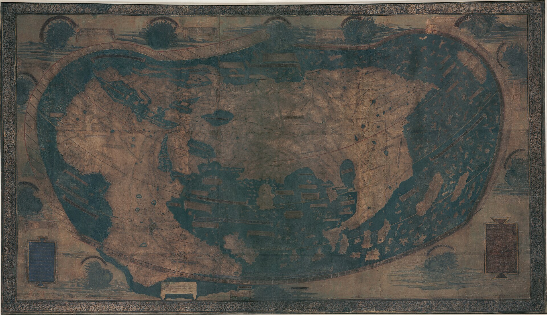
The full sheet, digitally stitched from two archival files by Yale. This is the object described in this record.
| Artist | Henricus Martellus Germanus |
|---|---|
| Date | c. 1489-1491 (most accounts fix it to about 1491, partly because one legend quotes a text published that year; estimates in the literature range from c. 1489 to c. 1492) |
| Medium | Hand-drawn and colored manuscript map, ink and pigment on a single large sheet. The exact ground material (paper or parchment) is not established in the sources consulted for this record. |
| Dimensions | Approximately 201 x 122 cm (about 6.6 x 4 ft), commonly rounded in press accounts to 6 by 4 feet. A precise institutional measurement was not accessible in the sources consulted. |
| Where it is now | Beinecke Rare Book & Manuscript Library, Yale University, New Haven, Connecticutlast confirmed |
| Inventory number | Yale University Library / Beinecke catalog record (collections.library.yale.edu/catalog/2007580; legacy record brbl-dl.library.yale.edu/vufind/Record/3435243). A specific Beinecke call or shelf number was not accessible in the sources consulted. |
| Attribution | AcceptedThe map carries a Latin inscription describing its purpose but no colophon or signature was found in the sources consulted for this record. Full note |
| Object type | Map |
| Period | Renaissance Florence, late fifteenth century |
| Cases | Has a provenance gap |
| Inscriptions | Extensive Latin descriptive legends and place names across the map, most illegible before 2014-15 and substantially recovered by multispectral imaging. Includes a programmatic inscription in which Martellus states his intent to go beyond Strabo and Ptolemy by incorporating newly discovered knowledge. |
| Owners on record | 3 links2 documented, 1 unknown |
| Sources | 15 cited |
About this record Last verified · 15 sources cited · Change log
On this page 9 sections
ContentsClose
A hand-drawn wall map of the known world, about two meters wide, made in Florence around 1491 by the German cartographer Henricus Martellus. Five centuries of fading left most of its Latin text and imagery invisible before a 2014-15 multispectral imaging project, led by the map historian Chet Van Duzer with imaging scientists from the Rochester Institute of Technology and the Early Manuscripts Electronic Library, recovered roughly four-fifths of what could be read: hundreds of place names, dozens of descriptive legends, and unusually detailed African geography that appears to trace back to an Ethiopian delegation at the 1441 Council of Florence.
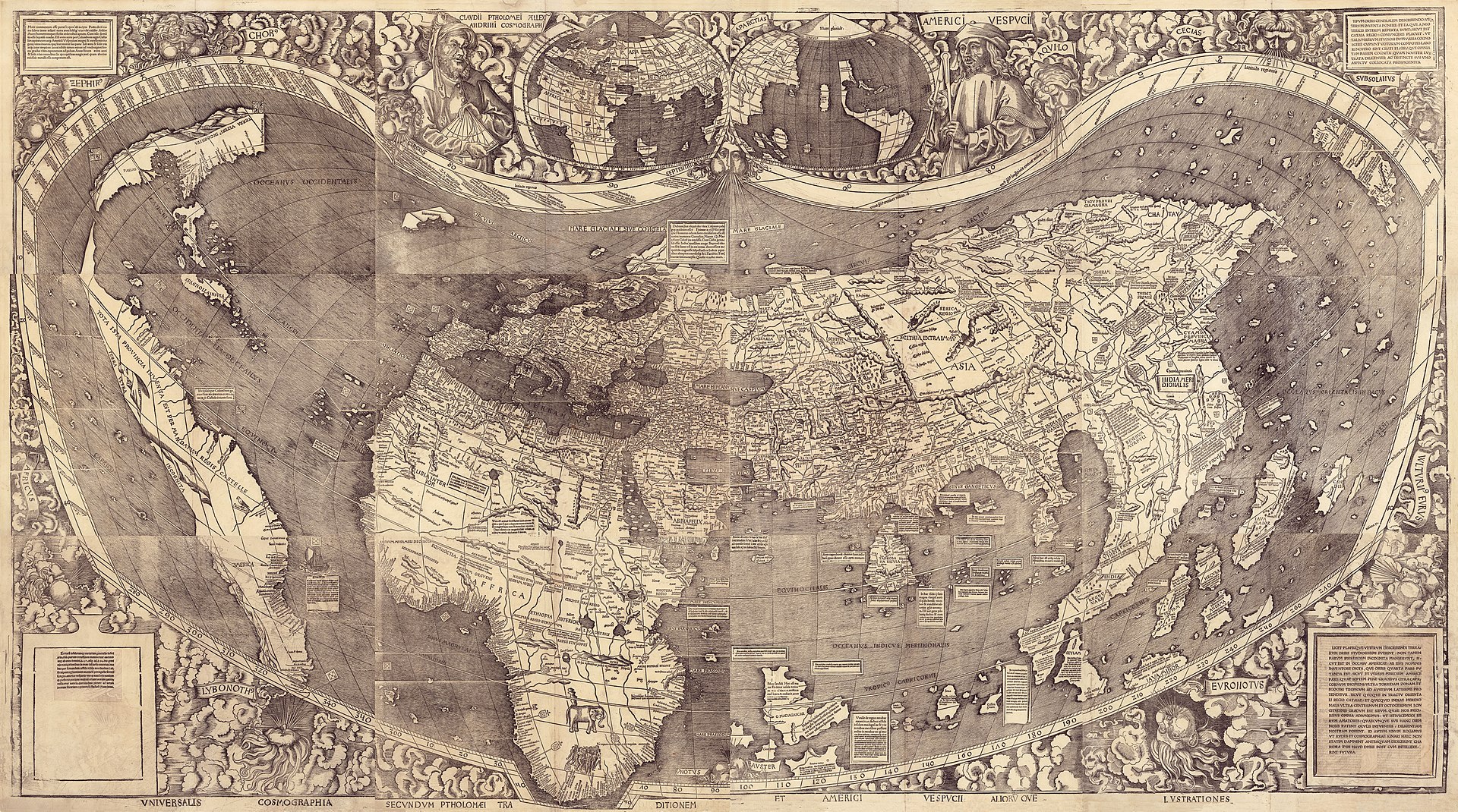
The map updates Ptolemy's Geography with fresh reports of Bartolomeu Dias's 1488 rounding of the Cape of Good Hope and draws on the Marco Polo tradition for Asia. Scholars argue, on the strength of Columbus's son Ferdinand's later account of his father's expectations about Japan, that Columbus consulted this map or one very like it before 1492; Van Duzer himself treats parts of that argument as reasonable speculation rather than proof. The map also appears to have supplied text, though not place names, to Martin Waldseemuller's 1507 map, the first to label the new continents America.
The Beinecke Library received the map as an anonymous gift in 1962; its ownership before that date is not established in the sources checked for this record. Martellus's other surviving world maps are page-sized illustrations bound into copies of his own island-book, held elsewhere including at the British Library; this large freestanding sheet at Yale is, so far as these sources establish, the only known example of his large-format wall map to survive.
Provenance
Each link is graded. Documented: a cited source supports it. Disputed: the identification is argued but not established. Unknown: no owner for that span, and the gap is not smoothed into a narrative. The grades in the glossary.
- c. 1489-1491 -Henricus Martellus Germanus (workshop, Florence)documented
Drawn by the German cartographer Henricus Martellus, active in Florence c. 1480-1496. The map is unsigned; its date is fixed to about 1491 in most scholarship, partly because one legend quotes a text published that year.612
- c. 1491 - 1962Unknownunknown
No ownership is documented in any source this record could directly verify for roughly four and a half centuries. Secondary, unverified summaries repeat a claim that the map belonged to a family in Tuscany, surfaced on the market in Bern in the late 1950s, and was offered by named dealers before an anonymous purchase; this record has not treated that chain as established fact because it could not be confirmed against a source actually fetched and read. See notes_for_editor.
- 1962 - presentBeinecke Rare Book & Manuscript Library, Yale Universitydocumented
Received by the Beinecke Library in 1962 as the gift of an anonymous donor. Displayed for a period on a wall outside the library's reading room; later moved into storage at the Yale University Art Gallery during a Beinecke renovation. Rendered legible in large part by the 2014-15 multispectral imaging project.123
Technical evidence
| Attribution note | The map carries a Latin inscription describing its purpose but no colophon or signature was found in the sources consulted for this record. Authorship is nonetheless treated as settled in the literature: R.A. Skelton and Roberto Almagia examined it directly around 1960 and supported its genuineness, and Chet Van Duzer's 2019 monograph treats it as securely Martellus's work, consistent with the style, legends and cartographic method of his other attributed manuscripts (the Insularium Illustratum copies and manuscripts of Ptolemy's Geographia). |
|---|---|
| Format | Single-sheet manuscript wall map, hand-drawn and colored, unbound, with Latin text throughout.12 |
| Dimensions | Approximately 201 x 122 cm (about 6.6 x 4 ft), rounded in most press accounts to 6 by 4 feet.612 |
| Imaging method, 2014 | Divided into 55 overlapping tiles; 22 images taken per tile across 12 reflective color bands spanning ultraviolet to infrared, then digitally stitched and processed. Funded by a National Endowment for the Humanities preservation grant (PW-51707-14).12479 |
| Recovery yield | Approximately 80 percent of the map's recoverable text rendered legible, per the earliest published accounts of the project's results.238 |
| Dating evidence | One legend on the map quotes a text published in 1491, used by scholars including Van Duzer to help fix the map's date to around that year.6 |
| Coordinate grid | Described in one cataloguing record as the only Martellus Dragon Tail map to carry a coordinate grid. Single-source claim, not independently corroborated for this record.14 |
| Principal sources synthesized | Ptolemy's Geographia as the base framework, updated with reports of Bartolomeu Dias's 1488 rounding of the Cape of Good Hope and, for Asia, the tradition descending from Marco Polo's account.510 |
Images
The record in full
Chapter 1What it is
A large hand-drawn wall map of the known world, roughly two meters wide and just over a meter tall, made in Florence around 1491 by the German cartographer Henricus Martellus.
A large hand-drawn wall map of the known world, roughly two meters wide and just over a meter tall, made in Florence around 1491 by the German cartographer Henricus Martellus. It runs from the Atlantic in the west to Japan in the east, covering Europe, Africa and Asia in the Ptolemaic tradition brought up to date with the latest Portuguese exploration reports. Latin text is scattered across the sheet: place names, longer descriptive legends about regions and peoples, and a programmatic inscription in which Martellus announces his intent to surpass Strabo and Ptolemy by folding in new knowledge.
Unlike the small, page-sized world maps Martellus also drew for his own island-book, the Insularium Illustratum, this is a single freestanding sheet meant to be looked at as a wall map, not turned as a page. That scale and format are part of why it survives as a distinct kind of object in Martellus's corpus, discussed further below.
Chapter 2Faded past use
Five centuries of fading and scuffing had reduced most of the map's text and fine detail to illegibility or invisibility by the twentieth century.
Five centuries of fading and scuffing had reduced most of the map's text and fine detail to illegibility or invisibility by the twentieth century. Chet Van Duzer, the map historian who eventually led the effort to recover it, described the situation starkly: almost all of the text had faded to the point of being unreadable, leaving what he judged perhaps the most important map of the fifteenth century effectively unstudiable.
Scholars had recognized the map's likely importance since it resurfaced in the mid-twentieth century, but without legible text there was little more to do than speculate about what it actually said.
Chapter 3The multispectral recovery project, 2014-2015
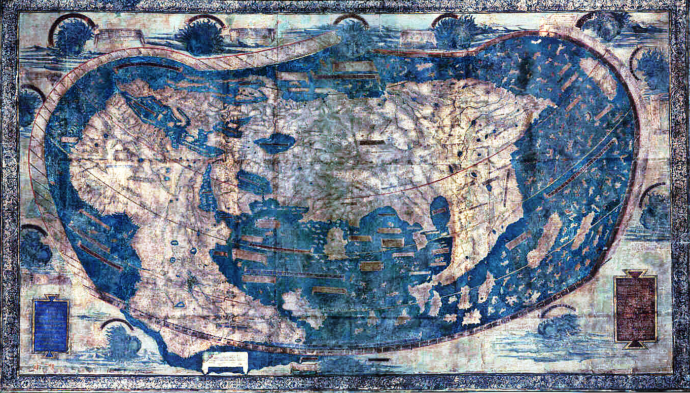
In August 2014 a five-person team funded by a National Endowment for the Humanities grant (PW-51707-14) brought a custom multispectral imaging rig to the Beinecke Rare Book & Manuscript Library.
In August 2014 a five-person team funded by a National Endowment for the Humanities grant (PW-51707-14) brought a custom multispectral imaging rig to the Beinecke Rare Book & Manuscript Library. Van Duzer directed the project. Roger Easton of the Chester F. Carlson Center for Imaging Science at the Rochester Institute of Technology handled the technical imaging science, working alongside Gregory Heyworth of the Lazarus Project at the University of Mississippi, Michael Phelps of the Early Manuscripts Electronic Library, and Kenneth Boydston of MegaVision, who supplied the imaging hardware.
The team divided the map into 55 overlapping tiles and photographed each one 22 times at varying wavelengths, spanning 12 reflective color bands from ultraviolet through infrared, frequencies that can pick up faded ink and pigment invisible under ordinary light. The images were digitally stitched and processed to bring out text the naked eye could no longer read. By the time of the first public accounts, the project had rendered roughly 80 percent of the map's recoverable text legible. The resulting images and metadata were released publicly through the Beinecke Library's digital collections in early 2015.
Chapter 4What the imaging recovered
The recovered text runs to hundreds of place names and around 60 substantial descriptive legends.
The recovered text runs to hundreds of place names and around 60 substantial descriptive legends. Some of it is fantastical in the tradition of medieval mappae mundi: descriptions of the Panotii, said to have ears large enough to wrap around their bodies, the horse-footed Hippopodes, and warnings about sea monsters including the orca in the Indian Ocean.
The more consequential recovery concerns Africa. Van Duzer's research argues that the map's unusually detailed depiction of Africa's interior traces back to information supplied by an Ethiopian delegation present at the Council of Florence in 1441, filtered through an intermediate source known as the Egyptus Novelo map. On that reading the Martellus map is not simply a European projection of African geography but a document that preserves, at one remove, African-sourced geographic knowledge, which Van Duzer calls a uniquely important record for the study of fifteenth-century African cartography.
Chapter 5Ptolemy corrected by new reports
Martellus built the map on Claudius Ptolemy's Geographia, the second-century framework that had reached Florence in Latin translation via Manuel Chrysoloras at the end of the fourteenth century and...
Martellus built the map on Claudius Ptolemy's Geographia, the second-century framework that had reached Florence in Latin translation via Manuel Chrysoloras at the end of the fourteenth century and become the working scaffold for European cartography. Onto that scaffold he grafted recent Portuguese exploration data, above all Bartolomeu Dias's 1488 rounding of the Cape of Good Hope, which for the first time gave European cartographers a documented sea route from the Atlantic into the Indian Ocean.
At least three legends on Martellus's maps cite the Portuguese explicitly, one stating that the map shows the modern true shape of Africa according to the map of the Portuguese, from the Mediterranean seas to the southern ocean. For Asia, Martellus worked within the tradition descending from Marco Polo's travel account rather than citing it directly, which is the source of the map's material on Cathay and Cipangu.
Chapter 6The Dragon Tail and a discredited theory
South of the Malay peninsula the map extends a long peninsula eastward and south, a feature cartographic historians call the Dragon Tail, the first appearance of that motif in surviving cartography.
South of the Malay peninsula the map extends a long peninsula eastward and south, a feature cartographic historians call the Dragon Tail, the first appearance of that motif in surviving cartography. It results from Martellus's attempt to reconcile Ptolemy's closed, landlocked Indian Ocean with the open sea the Portuguese had just proven existed around Africa; historians of cartography have not settled exactly how much of it reflects garbled real information about Southeast Asia against how much is invented to bridge the two traditions, and some popular accounts have speculatively linked it to geography later associated with South America. This record treats that identification as unresolved rather than established.
A different and more clearly settled dispute involves the historian Arthur Davies, who argued in the 1970s that Columbus's brother Bartholomew had deliberately distorted a Martellus-type map to persuade the Spanish crown to fund the 1492 voyage. That theory has not held up and is not treated as credible in the more recent literature consulted for this record.
Chapter 7The Columbus question
The most publicized claim about this map is that Christopher Columbus consulted it, or one very like it, before 1492, and that it shaped his miscalculation of how far Japan lay across the Atlantic.
The most publicized claim about this map is that Christopher Columbus consulted it, or one very like it, before 1492, and that it shaped his miscalculation of how far Japan lay across the Atlantic. The evidence is real but indirect. Columbus's son Ferdinand later recounted that his father expected to find Japan at roughly the distance and orientation at which Martellus's map places it, a configuration that does not appear so clearly on any other surviving contemporary map, and one crew member's account of the voyage describes southern Asia in terms consistent with how Martellus drew it.
Van Duzer's own language is more careful than the headlines built on his work. He has called the map's unusually accurate north-south orientation of Japan almost certainly a lucky guess rather than superior information, and has framed the argument that Columbus relied on Martellus's specific distance figures as reasonable to speculate, not as proven fact. The connection also cannot rule out that Columbus and Martellus drew independently on an earlier common source rather than Columbus using this particular map or a direct copy of it. The honest state of the argument is that a link between Martellus's cartography and Columbus's beliefs about the shape of Asia is well supported and widely accepted among specialists, while the claim that Columbus specifically examined this sheet is circumstantial.
Chapter 8After Martellus: Waldseemuller and beyond
Van Duzer's research also traces the map's afterlife in print.
Van Duzer's research also traces the map's afterlife in print. He demonstrates a close relationship between the Martellus map and Martin Waldseemuller's 1507 Universalis Cosmographia, the map that first applied the name America to the new continents: Waldseemuller drew substantially on Martellus's descriptive texts even where he chose different place names of his own. Some researchers have additionally argued that Martin Behaim's 1492 terrestrial globe, the Erdapfel, made in Nuremberg and the oldest surviving globe of its kind, drew on cartographic material closely related to Martellus's, though that connection is argued rather than documented and this record treats it as such.
Read together, the evidence places Martellus's map, or the tradition it represents, close to the center of European cartographic thinking at exactly the moment Europe's picture of the world's shape was being overturned by both the Portuguese voyages around Africa and the aftermath of Columbus's Atlantic crossing.
Chapter 9Into the Beinecke
The map came to Yale's Beinecke Rare Book & Manuscript Library in 1962 as the gift of an anonymous donor.
The map came to Yale's Beinecke Rare Book & Manuscript Library in 1962 as the gift of an anonymous donor. It was for a period displayed on a wall outside the library's reading room, a public presence unusual for an object of its fragility, and was later moved into storage at the Yale University Art Gallery during a Beinecke renovation.
How the map reached the point of that 1962 gift is not established by any source this record could directly verify. Secondary summaries repeat a more detailed account, that the map had belonged to a family in Tuscany for many years, surfaced on the market in Bern in the late 1950s, and was handled by named dealers before its anonymous purchase and donation to Yale, but every attempt to confirm that account against a source actually read for this record was blocked by a paywall or login wall. It is flagged in the open questions and editor notes below rather than stated as fact.
Chapter 10One map among several: version safety
Henricus Martellus's surviving cartographic output is not limited to this sheet.
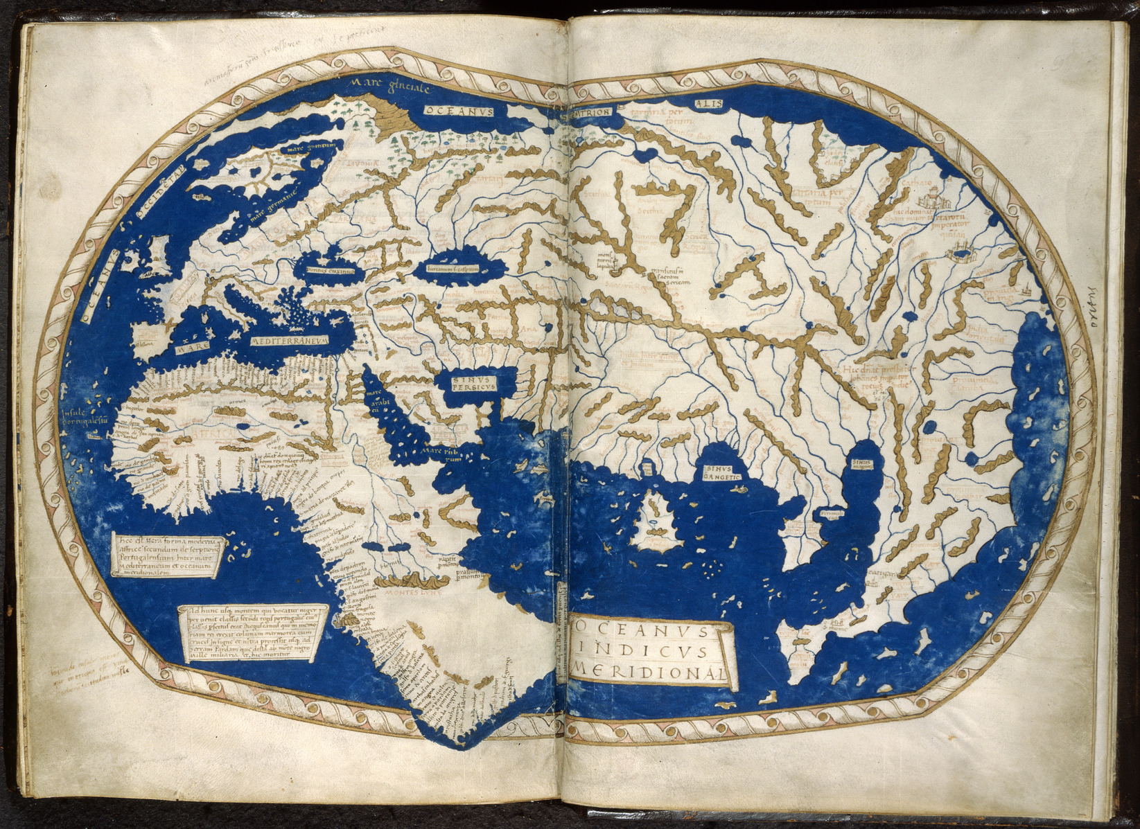
Henricus Martellus's surviving cartographic output is not limited to this sheet. Wikipedia's account of Martellus, checked directly for this record, lists five extant manuscripts of his Insularium Illustratum plus one working copy at the Biblioteca Medicea Laurenziana in Florence. At least one of those manuscript copies, held by the British Library as Add MS 15760, contains its own smaller world map, drawn on facing pages of the bound volume (folios 68v and 69r) rather than as a freestanding sheet. That British Library map shares the same Dragon Tail motif and the same general Ptolemaic-Portuguese synthesis as the Yale sheet, and the two are frequently mixed together online, including within the same Wikimedia Commons category, but they are not the same object: different institution, different physical form, different scale.
Based on the sources checked for this record, the large, freestanding wall map now at the Beinecke is the only known example of Martellus's big-format world map to survive; his other documented world maps are page-sized illustrations bound into copies of his own island-book. This record makes no claim beyond what these sources establish, and a fuller institutional census was not attempted.
The artist
Henricus Martellus Germanus (Latinized name; the German form is sometimes given as Heinrich Hammer)
Almost nothing is documented about Martellus's life outside his own cartographic output. His name is Latinized, as was standard scholarly practice in fifteenth-century Florence, and the surname Germanus is itself the clearest evidence of his origin: German by birth, working as an outsider in the Florentine map trade. No portrait, correspondence, contract or testament for him was found in the sources consulted for this record. He is known almost entirely through the maps and manuscripts that carry his name.
Related works
| Work | Relation | Where it is |
|---|---|---|
| World map, Insularium Illustratum (Add MS 15760, ff. 68v-69r) Henricus Martellus Germanus | A different, smaller world map by the same cartographer, drawn on facing pages inside a bound manuscript copy of his own island-book c. 1489. A distinct object from the Yale wall map: different institution, different physical form and scale. The two are frequently mixed together online, including sharing a Wikimedia Commons category; this record treats that as a version-confusion risk worth naming explicitly. | British Library, London |
| Manuscript copies of Insularium Illustratum Henricus Martellus Germanus | Martellus's other major surviving cartographic project, an illustrated island-book Five manuscripts plus one working copy are reported extant. Distinct in form and scale from the Yale wall map; at least one copy (the British Library volume above) includes its own smaller world map. | Multiple collections, including a working copy at the Biblioteca Medicea Laurenziana, Florence |
| Universalis Cosmographia Martin Waldseemuller | 1507 world map shown by Van Duzer's research to have drawn textual material from the Martellus map, though the two differ in many place names The first map to apply the name America to the new continents. The Martellus-to-Waldseemuller textual relationship is one of the central findings of the multispectral imaging project. | Library of Congress, Washington DC |
| Erdapfel globe Martin Behaim | The oldest surviving terrestrial globe, of 1492, argued by some researchers to draw on cartographic material closely related to Martellus's The Martellus-Behaim relationship is argued, not documented, and is treated that way in this record. Not illustrated here: no public-domain or CC0 photograph of the globe was identified during this research. | Germanisches Nationalmuseum, Nuremberg |
Open questions
- What is the map's chain of ownership between its creation in Florence around 1491 and its appearance at Yale in 1962? No source this record could directly verify establishes it. Secondary accounts repeat a claim involving a Tuscan family, a reappearance in Bern in the late 1950s, and named dealers, but every attempt to confirm that chain against a primary source was blocked by a paywall or login wall.
- Did Christopher Columbus consult this specific sheet, a now-lost copy of it, or an earlier source shared independently with Martellus? The evidence, chiefly Ferdinand Columbus's later account of his father's beliefs about Japan, is indirect and consistent with more than one explanation.
- What does the map's Dragon Tail peninsula south of Asia actually represent: a cartographic artifact of reconciling Ptolemaic and Portuguese data, or something closer to real, if garbled, information? Historians of cartography have not settled the question, and some popular accounts overstate a link to South America that the specialist literature does not establish.
- What is the map's exact support material and pigment set? No source consulted for this record reports a material analysis (paper versus parchment, or pigment identification), despite the imaging project's close physical engagement with the object.
- How much of the map's originally recoverable text remains unrecovered? The 2014-15 project reported roughly 80 percent legibility restored at the time of its first public accounts; whether a later pass closed the remaining gap is not established in the sources consulted.
Questions about this object
What is Henricus Martellus's World Map?
Henricus Martellus's World Map is a map, dated c. 1489-1491 (most accounts fix it to about 1491, partly because one legend quotes a text published that year; estimates in the literature range from c. 1489 to c. 1492). Medium: Hand-drawn and colored manuscript map, ink and pigment on a single large sheet. The exact ground material (paper or parchment) is not established in the sources consulted for this record.
Who made Henricus Martellus's World Map, and is the attribution settled?
The attribution to Henricus Martellus Germanus is recorded here as accepted. The map carries a Latin inscription describing its purpose but no colophon or signature was found in the sources consulted for this record. Authorship is nonetheless treated as settled in the literature: R.A. Skelton and Roberto Almagia examined it directly around 1960 and supported its genuineness, and Chet Van Duzer's 2019 monograph treats it as securely Martellus's work, consistent with the style, legends and cartographic method of his other attributed manuscripts (the Insularium Illustratum copies and manuscripts of Ptolemy's Geographia).
Where is Henricus Martellus's World Map now?
Beinecke Rare Book & Manuscript Library, Yale University, New Haven, Connecticut. Inventory number Yale University Library / Beinecke catalog record (collections.library.yale.edu/catalog/2007580; legacy record brbl-dl.library.yale.edu/vufind/Record/3435243). A specific Beinecke call or shelf number was not accessible in the sources consulted.. Last confirmed 20 August 2026. Acquired 1962 as the gift of an anonymous donor, per Beinecke's and Yale News's own accounts. Ownership before that date is not established in the sources this record could verify.
What is still unknown about Henricus Martellus's World Map?
What is the map's chain of ownership between its creation in Florence around 1491 and its appearance at Yale in 1962? No source this record could directly verify establishes it. Secondary accounts repeat a claim involving a Tuscan family, a reappearance in Bern in the late 1950s, and named dealers, but every attempt to confirm that chain against a primary source was blocked by a paywall or login wall.
Sources
- 1Beinecke Rare Book & Manuscript Library, Yale University, 'Hidden Secrets of Yale's 1491 World Map Revealed Via Multispectral Imaging'. beinecke.library.yale.edu/article/...
- 2Yale News, 'Hidden secrets of Yale's 1491 world map revealed via multispectral imaging', 11 June 2015. news.yale.edu/2015/...
- 3Phys.org, 'Hidden secrets of 1491 world map revealed via multispectral imaging', 2015. phys.org/news/...
- 4National Endowment for the Humanities, 'Columbus Sailed Here! Multi-Spectral Imaging of an Important 15th Century World Map'. neh.gov/divisions/...
- 5National Geographic, 'A 500-year-old map used by Columbus reveals its secrets'. nationalgeographic.com/culture/...
- 6Smithsonian Magazine, 'Did This Map Guide Columbus?'. smithsonianmag.com/history/...
- 7Archaeology Magazine, 'Digs & Discoveries: Reading the Invisible Ink', January/February 2016. archaeology.org/issues/...
- 8Hyperallergic, 'Researchers Decipher the Map That May Have Guided Columbus Westward'. hyperallergic.com/researchers-decipher-the-map-that-may-h...
- 9Early Manuscripts Electronic Library, 'Martellus Map Spectral Imaging Project'. emelibrary.org/martellus-map-spectral-imaging-project
- 10TheCollector, 'How the Martellus Map Saw Africa and Europe During the Age of Exploration'. thecollector.com/martellus-map
- 11Springer Nature Link, book landing page for Chet Van Duzer, 'Henricus Martellus's World Map at Yale (c. 1491): Multispectral Imaging, Sources, and Influence' (Cham: Springer, 2019). link.springer.com/book/...
- 12Wikipedia, 'Henricus Martellus Germanus'. en.wikipedia.org/wiki/...
- 13Wikimedia Commons, File:Henricus Martellus - Map of the world - 1489 - Yale archive.jpg, file information and licensing. commons.wikimedia.org/wiki/...
- 14Wikimedia Commons, File:Martellus-Yale.jpg, file information and licensing. commons.wikimedia.org/wiki/...
- 15Wikimedia Commons, File:World map by Martellus - Account of the Islands of the Mediterranean (1489), ff.68v-69 - BL Add MS 15760.jpg, file information and licensing. commons.wikimedia.org/wiki/...


,_ff.68v-69_-_BL_Add_MS_15760.jpg)
Last verified · Published
Change log
20 August 2026 - Record created at the house standard: researched narrative, technical evidence, maker dossier, graded provenance chain, prices with hammer and premium separated, related works, open questions and sources.