The Gough Map of Great Britain
Unknown maker or makers · Second half of the 14th century: traditionally c. 1360; c. 1370 (Linguistic Geographies); c. 1390 (Bodleian Maps blog, 2020); copying after 1399 proposed by the Gough Map Project (2022). Disputed.
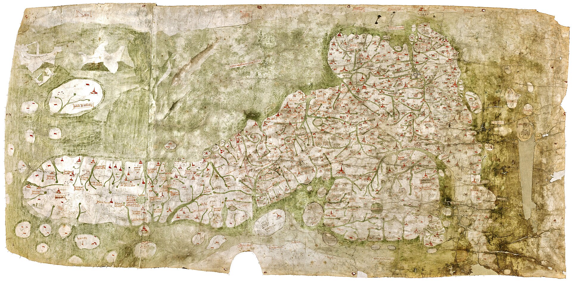
The whole map, east at the top, high-resolution scan from the Gough Map website (12224 x 6021 pixels). Public domain on Commons.
| Artist | Unknown maker or makers |
|---|---|
| Date | Second half of the 14th century: traditionally c. 1360; c. 1370 (Linguistic Geographies); c. 1390 (Bodleian Maps blog, 2020); copying after 1399 proposed by the Gough Map Project (2022). Disputed. |
| Medium | Manuscript on two sheepskin parchments joined vertically, flesh side, in black and red ink and colour, with gold lettering for London and York and a green wash for the sea and rivers |
| Dimensions | c. 553 x 1164 mm (UNESCO UK and Bodleian conservation page); 115 x 56 cm in rounded form (Bodleian Maps blog) |
| Where it is now | Bodleian Library, University of Oxfordlast confirmed |
| Inventory number | MS. Gough Gen. Top. 16 |
| Attribution | UnknownNo maker, patron or workshop is documented. Full note |
| Object type | Map |
| Period | English, later 14th century |
| Cases | Has a provenance gap |
| Inscriptions | Place names across the map; short red lines with distances in Roman numerals between many settlements; the back carries a paper lot label numbered 405 reading Old map of Great Britain, found during the 2006-2009 conservation. |
| Owners on record | 5 links3 documented, 1 disputed, 1 unknown |
| Sources | 18 cited |
About this record Last verified · 18 sources cited · Change log
On this page 10 sections
ContentsClose
The Gough Map is a manuscript map of the whole island of Britain on two joined sheepskins, held by the Bodleian Library as MS. Gough Gen. Top. 16. The Bodleian calls it the oldest surviving sheet map of Britain. Richard Gough bought it for half a crown at the sale of the collection of Thomas Martin of Palgrave on 20 May 1774 and it reached Oxford with his bequest in 1809.
Its date has moved more than once. It was long given as c. 1360, the Linguistic Geographies project proposed c. 1370 and the Bodleian now gives c. 1390, while the Gough Map Project argues the surviving sheet is a copy of a lost earlier map made no earlier than the reign of Henry IV. The red lines once read as medieval roads are now understood as routes with distances, added to a map that never was a road map. Date, maker, patron and purpose are all still disputed.
Provenance
Each link is graded. Documented: a cited source supports it. Disputed: the identification is argued but not established. Unknown: no owner for that span, and the gap is not smoothed into a narrative. The grades in the glossary.
- c. 1360-1430 -Maker or makers unknowndisputed
The surviving sheet is dated variously to c. 1360, c. 1370, c. 1390 and after 1399, and may be a copy of a lost earlier map. No maker or patron is documented.5674
- - before 1771Unknown, up to Thomas Martin of Palgraveunknown
Nothing is documented before the map appears in the collection of Thomas Martin of Palgrave. How and when Martin acquired it is not recorded in the sources consulted. The Bodleian's own catalogue is reported to record an earlier showing to the Society of Antiquaries in 1768, which could not be verified here.12
- before 1771 - 1774Thomas Martin of Palgrave (1696/7-1771) and then his collection, which passed to John Worth of Dissdocumented
Martin died on 7 March 1771; John Worth, a chemist of Diss, bought his collections for 600 pounds. The map was lot 405 in the sale of Martin's collection.1212
- 1774 - 1809Richard Gough (1735-1809)documented
Bought on 20 May 1774 for half a crown at the sale of Martin's collection. Published in Gough's British Topography in 1780.12481213
- 1809 - presentBodleian Library, University of Oxforddocumented
Entered the Bodleian in Gough's bequest in 1809, as MS. Gough Gen. Top. 16. Repaired in 1864; conserved 2006 to 2009; inscribed on the UK Memory of the World Register in 2011; exhibited in Talking Maps 2019-20.12414
Prices realised
| Date | Sale | Estimate | Result | Note |
|---|---|---|---|---|
| 20 May 1774 | Sale of the collection of Thomas Martin of Palgrave (auctioneer not identified in the sources consulted) | None recorded | Hammer 2s 6d (half a crown), the price paid by Gough; no separate buyer's premium is recorded With premium None recorded GBP (pre-decimal: two shillings and sixpence) | Lot 405, described as a curious and most ancient map of Great Britain. This is the only recorded sale. No modern auction history is known; no equivalent value is stated in the sources and none is given here. |
Hammer is the price at which the bidding stopped; with premium adds the fee the house charges the buyer on top. Hammer price and buyer's premium in the glossary.
Technical evidence
| Attribution note | No maker, patron or workshop is documented. The old ascription to Matthew Paris is not accepted. The Linguistic Geographies project (2010-11) set out to establish how many scribes worked on the manuscript, where they came from and when it was revised, using handwriting and the dialect form of the place names. A later team (the Gough Map Project) argues that the surviving sheet is a copy traced from a lost earlier map, the Predecessor, and was updated while being copied. Who the makers were, and for whom they worked, remains unestablished. |
|---|---|
| Support | Flesh side of two sheepskin parchments joined vertically; the left-hand skin shows what appears to be a lamb's backbone and ribcage in transmitted light. The Bodleian places the join north of Hadrian's Wall.14 |
| Join | Originally a running stitch, in place before the green wash of the sea was painted; now held by adhesive alone.12 |
| Dimensions | About 553 x 1164 mm (UNESCO UK, Bodleian conservation page); Smallwood gives 55.3 x 116.4 cm; the Bodleian Maps blog rounds to 115 x 56 cm.12411 |
| Medium | Black and red ink; sea and rivers tinted green; London and York in gold lettering.4511 |
| Orientation | East at the top.411 |
| Content | Over 200 rivers and over 600 towns, cities and settlements (Bodleian); 654 inhabited centres (Historia Cartarum summary).47 |
| Red lines | Straight red lines linking settlements, nearly all with a distance in Roman numerals, probably in old French miles.456 |
| Pinholes | Pinpricks at many settlement signs, evidence the map was traced from an earlier map; absent at some settlements, and, per the Wikipedia summary, in Kent, East Anglia and the south-west.56 |
| Lot label | Paper label numbered 405 reading Old map of Great Britain on the back, found during the 2006-2009 conservation.2 |
| Earlier repairs | Invasive repair of lacunae in 1864; textile lining; mid-19th-century patches on the back; rust-stained pinning holes at the edge.2 |
| Scientific study | 3D scanning, hyperspectral imaging and Raman spectroscopy; Leverhulme Trust grant RPG-2019-070.461016 |
| Mount and frame | Sprung stainless steel mount with linen threads, sealed stainless steel frame with laminated low-reflectance glass and acrylic, oak over-frame for display.2 |
Images
The record in full
Chapter 1What the object is
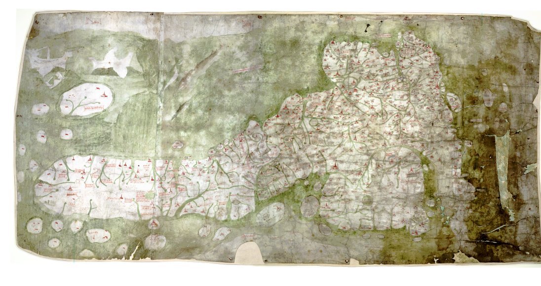
The Gough Map is a manuscript on parchment, about 553 by 1164 millimetres, showing England, Wales and Scotland with east at the top.
The Gough Map is a manuscript on parchment, about 553 by 1164 millimetres, showing England, Wales and Scotland with east at the top. It is drawn on two sheepskins joined vertically, and the Bodleian places the join north of Hadrian's Wall. Seen in transmitted light, the left-hand skin shows what appears to be a lamb's backbone and ribcage. The join was originally sewn with a running stitch, and the sewing was in place before the green wash of the sea was painted. It is now held by adhesive alone.
The Bodleian counts over 200 rivers and over 600 towns, cities and settlements; the Historia Cartarum summary of the project's work gives 654 inhabited centres. London and York are picked out in gold leaf. Calais is shown in detail at the edge of the map; Edward III took it in 1346. Black and red ink carry the writing and the sea and rivers are tinted green.
It is not a world map. T. M. Smallwood stressed the point in his 2010 article on its date: a regional map with an unusual density of correctly placed rivers and settlements, with no comparable European map known from before some years into the fifteenth century.
Chapter 2How Gough came to own it, and how it came to Oxford
Richard Gough (1735-1809), a Fellow of the Society of Antiquaries from 1767 and its director from 1771 to 1791, bought the map on 20 May 1774 at the sale of the collection of Thomas Martin of...
Richard Gough (1735-1809), a Fellow of the Society of Antiquaries from 1767 and its director from 1771 to 1791, bought the map on 20 May 1774 at the sale of the collection of Thomas Martin of Palgrave. It was lot 405, described in the sale as a curious and most ancient map of Great Britain, and he paid half a crown, two shillings and sixpence. The Bodleian gives the same price as 12 and a half pence.
Martin, known as Honest Tom Martin, was born at Thetford in 1696 or 1697 and died at Palgrave in Suffolk on 7 March 1771. He had been forced by money troubles to sell some of his books and manuscripts in his lifetime. After his death a chemist of Diss, John Worth, bought his collections for 600 pounds. Booth and Berry of Norwich sold the printed books in 1773, Samuel Baker sold part of the manuscripts in London in April 1773, and a second sale of manuscripts, books, drawings, coins and curiosities followed in May 1774. The 20 May 1774 date given for Gough's purchase falls inside that May sale, although none of the sources consulted states the link in so many words.
Gough published the map in his British Topography of 1780, which is the source of the first modern copy. After his death in 1809 his topographical collection, together with the Sheldon tapestry maps, came to the Bodleian. The Bodleian's own conservation page records that the map arrived in 1809 in his bequest.
Chapter 3Eighteenth and nineteenth century treatment
The conservation project of 2006 to 2009 uncovered how the sheet was handled before it was treated.
The conservation project of 2006 to 2009 uncovered how the sheet was handled before it was treated. It seems to have been rolled and then pinned to a support, which left rust-stained holes around the edge. A textile lining caused distortion and loss of paint, and mid-nineteenth-century patches had been stuck to the back. An invasive repair of the gaps in the parchment was made in 1864. On the back the team found a paper lot label numbered 405 reading Old map of Great Britain, which confirmed the 1774 purchase.
The area of southern England, including the Bristol and English Channels, was more abraded and grimed than the rest. Grey stains over some place names come from a reagent made of oak galls and Madeira wine, applied at Gough's request to make faded writing legible, according to the Wikipedia summary of the project's findings. That detail is carried here as a tertiary claim awaiting a primary citation.
Chapter 4The Ordnance Survey facsimile and the scholarly dating
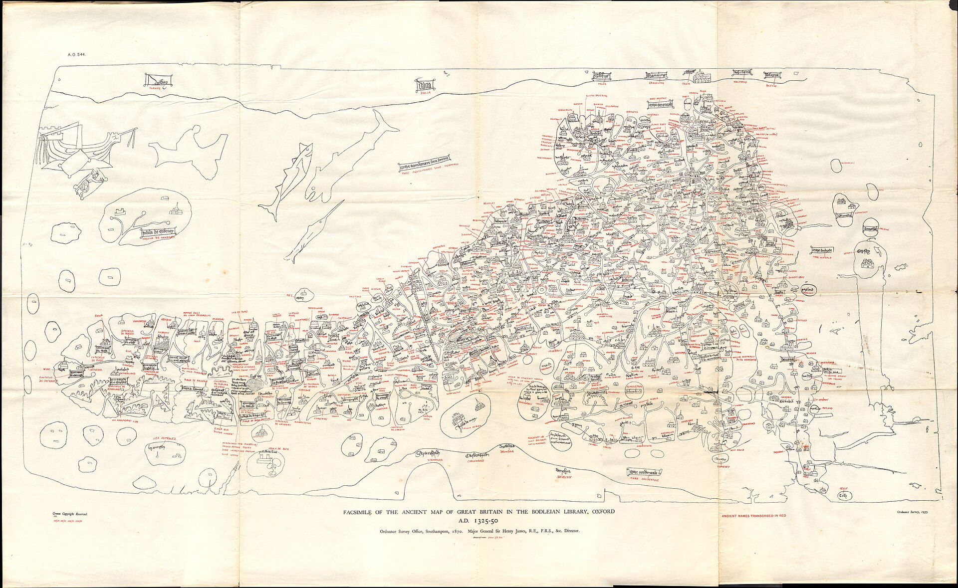
The first modern reproduction was made by the Ordnance Survey, as a zincograph in the volume Facsimiles of National Manuscripts of Scotland by Colonel Sir Henry James; the Historia Cartarum...
The first modern reproduction was made by the Ordnance Survey, as a zincograph in the volume Facsimiles of National Manuscripts of Scotland by Colonel Sir Henry James; the Historia Cartarum bibliography gives the date as 1870 and the imprint as 1871. The Ordnance Survey facsimile carried a date of c. 1300, attributed to W. B. Sanders. It is a facsimile, a different object from the map, and its date is not evidence for the date of the map.
Nineteenth-century opinion therefore favoured Edward I, c. 1300, while Thomas Martin himself had thought the map belonged to the reign of Edward III. In 1958 E. J. S. Parsons issued the Bodleian and Royal Geographical Society facsimile, The Map of Great Britain circa A.D. 1360 known as the Gough Map, with a chapter by Sir Frank Stenton on the roads of the map, and called the map an official compilation. That is the origin of the c. 1360 date, which was later narrowed by the evidence of internal names: a city wall around Coventry begun in 1355 gives the earliest limit, and the renaming of Sheppey as Queenborough in 1366 the later.
Chapter 5The red lines are routes, not roads
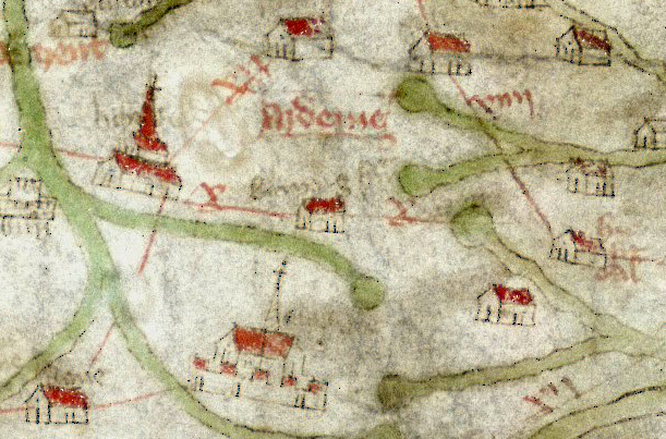
Narrow red lines link settlements across much of England and Wales, and nearly all carry a distance in Roman numerals.
Narrow red lines link settlements across much of England and Wales, and nearly all carry a distance in Roman numerals. The Bodleian's 2020 blog notes the numbers probably give distances in old French miles. Gough called the lines roads and the Bodleian's 2007 book by Nick Millea asked in its title whether this was the earliest road map of Great Britain. Stenton's 1936 article on the road system of medieval England and his 1958 chapter treated them as a network of roads.
The modern reading is different. The Gough Map Project reports that the red lines were not on the Predecessor, so the earlier map was never a road map; the lines are at best routes, added by the copyist, and may have helped readers use a regional map, itself a fairly new kind of object at the start of the fifteenth century. There are no routes from London to the south or east and large parts of Watling Street are omitted, which fits a selective set of itineraries rather than a survey of roads. Parsons's claim that the map served travellers is now questioned.
Chapter 6The Linguistic Geographies project, 2010-11
The Linguistic Geographies project, funded by the Arts and Humanities Research Council under its Beyond Text programme, ran from April 2010 to July 2011.
The Linguistic Geographies project, funded by the Arts and Humanities Research Council under its Beyond Text programme, ran from April 2010 to July 2011. It was directed by Keith Lilley of Queen's University Belfast, with Nick Millea of the Bodleian and Paul Vetch of King's College London as co-investigators. It combined a palaeographic study of the map with study of the linguistic form of the place names, which may reflect the dialect of the scribes, and set out to establish how many scribes worked on it, where they came from and what their exemplars were like. It also built an interactive online edition, developing a version first made in 2005 under a British Academy grant.
The project's conclusion was a date in the second half of the fourteenth century, c. 1370. Elizabeth Solopova's study for the project found the map was first made in the 1370s and extensively revised not long afterwards, perhaps as late as 1430, according to the Wikipedia summary. Overwriting of some place names shows the map was still in use well into the fifteenth century. Solopova's argument has been criticised on the ground that the claimed extensive erasure of earlier writing is not evident in the area said to be revised.
The online edition was withdrawn on 29 November 2024 as a cybersecurity precaution; a digitised facsimile remains available through Digital Bodleian.
Chapter 7The Gough Map Project: a copy, and a ghost behind it
A second research effort began in 2012 under Catherine Delano-Smith.
A second research effort began in 2012 under Catherine Delano-Smith. It used hyperspectral imaging, one of the first uses of that technique at the Weston Library in 2015, together with Raman pigment analysis and 3D scanning. In its last three years it was funded by the Leverhulme Trust (grant RPG-2019-070). About three dozen people took part, including palaeographers and place-name specialists. The interim result was published in Imago Mundi 69:1 (2017), 1 to 36, as New Light on the Medieval Gough Map of Britain, by Delano-Smith and nine co-authors.
The project's central finding, as summarised by William Shannon in 2022, concerns pinholes. Many settlement signs are marked by pinpricks, made with an awl, which show the surviving sheet was traced from an earlier map, the Predecessor. Not every settlement has pinholes, so the copyist appears to have updated the Predecessor rather than reproduce it. The project suggests the copy was made in the early years of Henry IV, from 1399, although the date of the Predecessor is unknown. The Wikipedia summary reports the same work as three layers, a first of 1390 to 1410 for the whole of Britain, a second of the first quarter of the fifteenth century for England south of the Wall and Wales, and a third of the last quarter of the century for the south-east and south-central England; that summary also notes the pinholes are absent in Kent, East Anglia and the south-west. These layer dates are carried here as tertiary and unconfirmed against the 2017 paper, which was not accessible.
The project concludes that the map was a practical working document and not a showpiece. Daniel Birkholz had proposed instead that it was a display object making a political statement about Britain as a single monarchy. A research volume with Brill was announced for after 2025.
Chapter 8Conservation, housing and display
Christopher Clarkson, consultant to the Bodleian, and Marinita Stiglitz, Head of Paper Conservation, treated the map between 2006 and 2009, funded by Brian Wilson of the Friends of the Bodleian.
Christopher Clarkson, consultant to the Bodleian, and Marinita Stiglitz, Head of Paper Conservation, treated the map between 2006 and 2009, funded by Brian Wilson of the Friends of the Bodleian. Clarkson had written an internal report on its condition and future preservation in 2006, and the two published an account in the Bodleian Library Record 22:2 (2009), 212 to 224.
Flaking paint was consolidated and the surface cleaned with soft brushes and vinyl erasers. The textile lining was lifted off, the patches and adhesive removed, fragile areas repaired with Japanese paper and new toned sheepskin with gelatine adhesive. The map was humidified several times and straightened with clips and pins. The result stabilised the paint and let the parchment recover part of its flexibility and appearance. It is now mounted on a sprung stainless steel mount with linen threads, in a sealed frame of stainless steel with laminated low-reflectance glass and acrylic that allows the back to be examined, and in a simple oak over-frame while on display.
The conservation project dates 2006 to 2009 are those the Bodleian gives; no conservation of 2017 or 2018 was found.
Chapter 9Recognition and exhibition
The map was inscribed on the UK Memory of the World Register in 2011, nominated by the Bodleian.
The map was inscribed on the UK Memory of the World Register in 2011, nominated by the Bodleian. The UK register describes it as the earliest surviving map to show routes across Britain and the first to depict a recognisable coastline. A digital version was published by the Bodleian in 2011. The BBC series In Search of Medieval Britain (2008) used it, with Alixe Bovey retracing medieval journeys.
The map was one of the highlights of the exhibition Talking Maps, curated by Jerry Brotton and Nick Millea at the Weston Library from 5 July 2019 to 8 March 2020, with a companion book that discusses the map's purpose. The 2020 catalogue The Aura in the Age of Digital Materiality, published by Factum Arte, carries an essay by Catherine Delano-Smith and Damien Bove on the map.
Chapter 10Who made it, for whom, and why: what is not known
The maker is unknown. Wikipedia's summary of the literature records the hypotheses: information may have come from one or more men who travelled in Edward I's Welsh and Scottish campaigns, where the...
The maker is unknown. Wikipedia's summary of the literature records the hypotheses: information may have come from one or more men who travelled in Edward I's Welsh and Scottish campaigns, where the fringe detail is most accurate; accuracy in South Yorkshire and Lincolnshire suggests an author from that region; accuracy in Oxfordshire may reflect William Rede's calculation of Oxford's coordinates in 1340. Smallwood in 2010 argued that the c. 1360 dating rests on invalid arguments, asked whether the map is original or a copy, and whether its makers borrowed from a prototype tied to the wars of Edward I, and placed it in the early fifteenth century.
The map has some errors that the sources record: Anglesey and Windermere are oversized, rivers are emphasised, the Durham peninsula is over-prominent and Scotland is poorly depicted. It also contains myth treated as fact, such as the landings of Brutus in Devon. In 2022 Simon Haslett and David Willis argued that two islands in Cardigan Bay shown on the map, long taken as phantoms, probably existed when it was made. No patron is named in any source consulted and no document about the commission survives in the sources consulted.
The artist
Maker or makers unknown; the scribes of the Gough Map and its later revisers
No name attaches to the Gough Map. The old ascription to Matthew Paris is not accepted and nothing in the sources consulted supports any named hand. What the research has produced instead is a description of the work: several scribes over a long period, a copy traced from a lost earlier map, and revisions that kept the map in use into the fifteenth century. The dossier is therefore about the maker as a problem, not a person.
Related works
| Work | Relation | Where it is |
|---|---|---|
| Facsimile of the ancient map of Great Britain in the Bodleian Library (Ordnance Survey, 1870) Ordnance Survey, under Col. Sir Henry James | Modern facsimile; a different object, and the source of the date c. 1300 attributed to W. B. Sanders A black and white zincograph; a later edition transcribed ancient names in red (dated 1935 on Commons, 1937 in one bibliography). | Published in Facsimiles of National Manuscripts of Scotland (imprint 1871) |
| The Map of Great Britain circa A.D. 1360 known as the Gough Map (1958 facsimile) E. J. S. Parsons, with Sir Frank Stenton | Bodleian and Royal Geographical Society facsimile in two sheets with overlays; source of the c. 1360 date Reprinted 1970 with minor revisions. | Oxford, Bodleian Library Map Reproduction 1 |
| Matthew Paris itinerary maps (Royal MS 14 C VII) Matthew Paris | Different object; a thirteenth-century route diagram, not the Gough Map Included only to prevent version confusion; the ascription of the Gough Map to Matthew Paris is rejected. | British Library |
| Hereford Mappa Mundi Unknown | Different object; a world map, not a regional map Included only to prevent version confusion. | Hereford Cathedral |
| Sheldon Tapestry Maps Sheldon workshop | Came to the Bodleian with Gough's collection Tapestry county maps, a separate object conserved by the Bodleian. | Bodleian Library, Oxford |
Open questions
- Who made the map, in what circumstances and for whom? No maker or patron is named in any source consulted.
- When was the surviving sheet made: c. 1360, c. 1370, c. 1390 or after 1399? The Bodleian blog gives c. 1390, Linguistic Geographies c. 1370 and the Gough Map Project proposes the early years of Henry IV.
- What was the lost Predecessor map, when and where was it made, and why? The Gough Map Project calls this open.
- Where was the map before Thomas Martin of Palgrave, and how did he acquire it? Nothing before the 1774 sale is documented in the sources consulted.
- Was it a practical working document or a display object? The Gough Map Project and Daniel Birkholz disagree.
- Do the layer dates reported for the 2017 interim paper hold? The three-layer summary is known only through a tertiary source here, and the full Brill volume is announced for after 2025.
- How far did the revisions go in the south of England, and do they show erasure of earlier writing? Solopova's reading is contested.
- What exactly do the numbers on the red lines measure, and why are routes from London to the south and east missing? Distances in old French miles are suggested, not proven.
Questions about this object
What is The Gough Map of Great Britain?
The Gough Map of Great Britain is a map, dated second half of the 14th century: traditionally c. 1360; c. 1370 (Linguistic Geographies); c. 1390 (Bodleian Maps blog, 2020); copying after 1399 proposed by the Gough Map Project (2022). Disputed.. Medium: Manuscript on two sheepskin parchments joined vertically, flesh side, in black and red ink and colour, with gold lettering for London and York and a green wash for the sea and rivers.
Who made The Gough Map of Great Britain, and is the attribution settled?
The attribution to Unknown maker or makers is recorded here as unknown. No maker, patron or workshop is documented. The old ascription to Matthew Paris is not accepted. The Linguistic Geographies project (2010-11) set out to establish how many scribes worked on the manuscript, where they came from and when it was revised, using handwriting and the dialect form of the place names. A later team (the Gough Map Project) argues that the surviving sheet is a copy traced from a lost earlier map, the Predecessor, and was updated while being copied. Who the makers were, and for whom they worked, remains unestablished.
Where is The Gough Map of Great Britain now?
Bodleian Library, University of Oxford. Inventory number MS. Gough Gen. Top. 16. Last confirmed 2 August 2026. Entered the Bodleian in 1809 with the bequest of Richard Gough. Shown in the Talking Maps exhibition at the Weston Library, 5 July 2019 to 8 March 2020.
What has The Gough Map of Great Britain sold for?
Hammer 2s 6d (half a crown), the price paid by Gough; no separate buyer's premium is recorded; with premium, None recorded. Sale of the collection of Thomas Martin of Palgrave (auctioneer not identified in the sources consulted), 1774-05-20.
What is still unknown about The Gough Map of Great Britain?
Who made the map, in what circumstances and for whom? No maker or patron is named in any source consulted.
Sources
- 1UNESCO UK, Memory of the World Register, The Gough Map (provenance, lot 405, price, dimensions, support, inscription 2011). unesco.org.uk/our-sites/...
- 2Bodleian Libraries, The Gough Map conservation project 2006-2009 (Clarkson and Stiglitz; repairs of 1864; lot label; housing). bodleian.ox.ac.uk/node/...
- 3Clarkson, C. and Stiglitz, M., The Gough Map - Its Nature, Conservation History and Display, Bodleian Library Record 22:2 (2009), 212-224, Oxford ORA record. ora.ox.ac.uk/objects/...
- 4Bodleian Libraries Maps blog, Mr. Gough's map, 22 April 2020 (c1390, price, skin, red lines, research methods, Talking Maps). blogs.bodleian.ox.ac.uk/maps/...
- 5Wikipedia, Gough Map. en.wikipedia.org/wiki/...
- 6Shannon, W. D., The Gough Map Project: A Tale of Two Maps, On History (Institute of Historical Research blog), April 2022. blog.history.ac.uk/2022/...
- 7Petrovskaia, N., Medieval maps: the Gough Map, Defining Europe project blog, Utrecht University, 2018. definingeurope.sites.uu.nl/2018/...
- 8Historia Cartarum, Chronological Gough Map Bibliography (Gough 1780; OS 1870/1871; Stenton 1936; Parsons 1958; Millea 2007; Smallwood 2010; Solopova 2012). historiacartarum.org
- 9Historia Cartarum, Extended Gough Map Bibliography (conservation, red lines and acquisition literature). historiacartarum.org/medieval-maps-and-mapping-resources/...
- 10Bodleian Libraries, Gough Map of Great Britain, research project page (Leverhulme RPG-2019-070; online edition withdrawn 29 November 2024; Brill volume). goughmap.bodleian.ox.ac.uk
- 11Medievalists.net, excerpt of T. M. Smallwood, The Date of the Gough Map, Imago Mundi 62:1 (2010). medievalists.net/2017/...
- 12Wikipedia, Thomas Martin of Palgrave. en.wikipedia.org/wiki/...
- 13Wikipedia, Richard Gough (antiquary). en.wikipedia.org/wiki/...
- 14Map Room Blog, Talking Maps, 2019 (exhibition dates, curators, Gough Map as a highlight). maproomblog.com/2019/...
- 15Map Room Blog, The Gough Map and Its Ghostly Predecessor, 28 April 2022. maproomblog.com/tag/...
- 16The Art Newspaper, Oxford's Weston Library to dust for hyperspectral fingerprints, 7 April 2015. theartnewspaper.com/2015/...
- 17Wikimedia Commons file metadata (titles, dimensions, licence: Public domain) for the four files used. commons.wikimedia.org/wiki/...
- 18Bodleian Libraries, The Conveyor blog, Gough Map project (Beyond Text, April 2010 to July 2011; aims and methods). blogs.bodleian.ox.ac.uk/theconveyor/...

Last verified · Published
Change log
16 November 2026 - Record created at the house standard: researched narrative, technical evidence, maker dossier, graded provenance chain, prices with hammer and premium separated, related works, open questions and sources.