Hereford Mappa Mundi
Richard of Haldingham and Lafford (identity disputed) · c. 1300 (dated on palaeographic and art-historical grounds to between c. 1290 and c. 1310; the oak backboard is dendrochronologically dated to trees felled around 1295-1300)
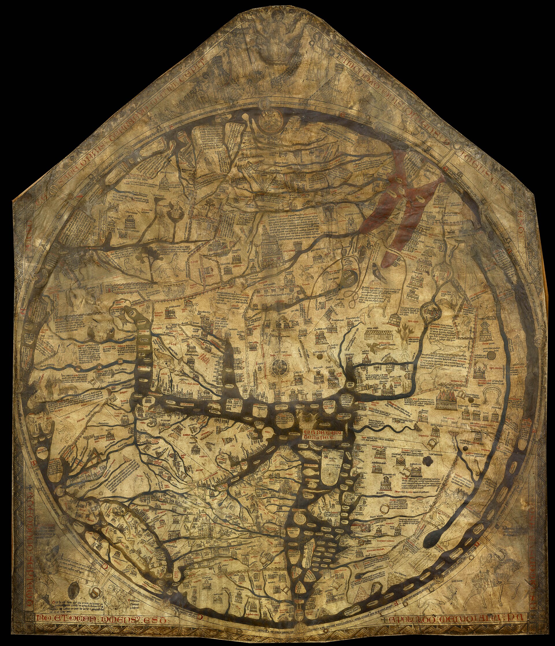
The Hereford Mappa Mundi on display at Hereford Cathedral. Photographed 7 January 2009 with a professional medium-format digital camera back, sourced via the United Kingdom National Commission for UNESCO's website in connection with the map's 2006 Memory of the World nomination. Public domain: a flat two-dimensional reproduction of a manuscript map whose maker died over 600 years ago (see notes_for_editor for the Section 68 UrhG reasoning). (Treated here as a direct photograph of the object on the balance of the evidence; the Commons file page does not itself confirm this in so many words, as opposed to a professionally produced reproduction made for the 2006 UNESCO nomination.)
| Artist | Richard of Haldingham and Lafford (identity disputed) |
|---|---|
| Date | c. 1300 (dated on palaeographic and art-historical grounds to between c. 1290 and c. 1310; the oak backboard is dendrochronologically dated to trees felled around 1295-1300) |
| Medium | Iron gall ink, pigment (red, gold, blue and green) and gold leaf on a single sheet of vellum, mounted since the Middle Ages on an oak backboard |
| Dimensions | Approximately 158 x 133 cm per most published accounts, though the United Kingdom's 2006 UNESCO Memory of the World nomination (compiled with the owning Trust) gives 1626 mm x 1346 mm; the circular map field itself is roughly 132 cm in diameter. This record treats the small discrepancy as unresolved and cites both figures rather than silently rounding one away. |
| Where it is now | Hereford Cathedral, Hereford, England, in the purpose-built Mappa Mundi and Chained Library exhibitionlast confirmed |
| Inventory number | No public catalogue or accession number is published; the map is not part of a numbered museum collection |
| Attribution | DisputedThe map carries no signature in the modern sense. Full note |
| Object type | Map |
| Period | English, late thirteenth century |
| Cases | Disputed attribution · Has a provenance gap |
| Inscriptions | An Anglo-Norman French verse in the lower left corner: 'Tuz ki cest estorie ont / Ou oyront ou lirront / Ou ueront...' asking prayer for Richard of Haldingham and Lafford, who made and laid it out (fet e compasse). The Last Judgement roundel above the map is ringed with the letters M O R S (Latin: death), a memento mori addressed directly to the viewer. |
| Owners on record | 10 links8 documented, 2 unknown |
| Sources | 24 cited |
About this record Last verified · 24 sources cited · Change log
On this page 9 sections
ContentsClose
A single sheet of vellum, roughly a metre and a half across, drawn around 1300 with Jerusalem at its centre and the known world arranged around it as a visual encyclopaedia of biblical history, classical learning and Christian judgement: it is the largest medieval world map to survive complete, and it has hung at Hereford Cathedral for most of its life. Its inscribed maker, 'Richard of Haldingham and Lafford', has never been securely identified, and scholars disagree on where in the cathedral it originally hung, whether it was made at Hereford or brought from Lincoln, and whether its most famous labelling quirk - Africa and Europe's legends swapped - is an error or a deliberate device.
In 1988 the Dean and Chapter proposed selling it through Sotheby's to raise a stated seven-million-pound endowment for the cathedral, triggering parliamentary debate in both Houses and a public campaign that forced the sale's withdrawal in February 1989. A rescue package assembled by the National Heritage Memorial Fund (two million pounds, conditional on a matching public appeal) and Mr J. Paul Getty (a further one million pounds) kept the map at Hereford, and the newly formed Hereford Mappa Mundi Trust took ownership on terms that removed the Chapter's power to sell it again. A purpose-built library building, opened by the Queen in 1996, has housed the map ever since.
This record leaves several things openly unresolved rather than smoothing them into a clean story: the actual sum the 1989 public appeal raised, Sotheby's own valuation before the sale was withdrawn, and the identity behind the map's own six-hundred-year-old plea for prayer.
Provenance
Each link is graded. Documented: a cited source supports it. Disputed: the identification is argued but not established. Unknown: no owner for that span, and the gap is not smoothed into a narrative. The grades in the glossary.
- c. 1287-1300 -Hereford Cathedral (Dean and Chapter)documented
Made for, or brought to, Hereford Cathedral around the time of the promotion of the cult of St Thomas de Cantilupe, whose remains were translated to an enlarged shrine in 1287. Scholars disagree on whether the map's original display position was in the north transept beside the shrine itself (Terkla, 2004) or on a wall in the south choir aisle near Cantilupe's tomb (de Wesselow, 2013); both are argued positions rather than settled fact.6910
- c. 1300s - 1640sHereford Cathedral (Dean and Chapter)unknown
Continuous display and custody through the fourteenth to seventeenth centuries is asserted in tertiary summaries but not documented in detail in the sources located for this record; this record flags the gap rather than inventing a continuous narrative.14
- 1640s - Restoration eraHereford Cathedral (Dean and Chapter)unknown
During the English Civil War the map is reported to have been hidden beneath the floor of Bishop Audley's Chantry within the cathedral, presumably to protect it from disruption to church property during the period. This account rests solely on Wikipedia's article on the map, a tertiary source flagged for replacement with the Cathedral's own archival record.14
- 1855 - 1855Hereford Cathedral (Dean and Chapter)documented
Cleaned and repaired at the British Museum in 1855; small holes were subsequently patched with replacement parchment coloured to match the medieval surface.614
- 1939 - 1946Hereford Cathedral (Dean and Chapter)documented
Removed from the cathedral for safekeeping during the Second World War; returned to display in 1946. Sourced here to Wikipedia's article on the map; the wider practice of evacuating British cultural treasures during the Second World War is well corroborated independently, though this specific case has not been checked against the Cathedral's own archival record.14
- winter 1987-88 - 1988Hereford Cathedral (Dean and Chapter)documented
Displayed publicly at the Royal Academy's Age of Chivalry exhibition over the winter of 1987-88, and returned to Hereford shortly before the proposed sale became public.5
- November 1988 - end of February 1989Hereford Cathedral (Dean and Chapter)documented
The Dean and Chapter announced their intention to sell the map at auction via Sotheby's, stating an aim of raising a seven-million-pound endowment for the cathedral's finances (against a separately reported advisers' recommendation of at least six million pounds). The plan provoked debates in both Houses of Parliament (5, 6 and 21 December 1988). No published Sotheby's valuation of the map has been located. The Dean and Chapter withdrew the map from auction at the end of February 1989, before a full rescue package was finalised, and briefly proposed an alternative scheme selling shares in a company at 1,000 pounds each with a replica for each shareholder; this scheme was not proceeded with.12345
- 17 February 1989 - 1989Hereford Mappa Mundi Trust (newly formed charity)documented
The National Heritage Memorial Fund offered two million pounds, conditional on a matching public appeal of a similar sum; Mr J. Paul Getty (later Sir Paul Getty KBE) offered a further one million pounds. Together with the anticipated public appeal this totalled approximately five million pounds against the Chapter's stated seven-million target. This record cannot confirm the final sum actually raised by the public appeal, nor whether Getty's gift came from him personally or via a charitable trust in his name; both gaps are flagged rather than filled by assumption. The Hereford Mappa Mundi Trust was created to hold permanent, non-saleable ownership of the map (and the Cathedral's Chained Library) going forward.413
- 1989 - 1996Hereford Mappa Mundi Trustdocumented
A purpose-built library building, designed by William Whitfield, was constructed in the south-east corner of the Cathedral close to house the map and the Chained Library, opened by Queen Elizabeth II on 5 May 1996, and awarded the Royal Fine Art Commission's Building of the Year award in 1997.1314
- 1996 - presentHereford Mappa Mundi Trustdocumented
On permanent public display in the Mappa Mundi and Chained Library exhibition at Hereford Cathedral, in a sealed, environmentally controlled case, delegated by the Trust to the Dean and Chapter for day-to-day care and exhibition. The Trust's deed provides that ownership passes to the British Library, London, should the Trust ever be dissolved.613
Technical evidence
| Attribution note | The map carries no signature in the modern sense. Its only claim to authorship is an Anglo-Norman French verse inscription in the lower left corner asking those who see it to pray for 'Richard of Haldingham and Lafford, who made and laid it out' (fet e compasse). Scholars have never agreed on who this Richard was, whether the inscription names a designer, a supervising scribe, or a patron who commissioned and gave the map rather than drew it, or whether he produced the design himself or adapted an earlier exemplar. The United Kingdom's own 2006 nomination of the map to the UNESCO Memory of the World Register states the problem plainly: it is not clear who he was, or whether he created the Hereford map or only its exemplar. The strongest identification on record links him to a Richard de Bello, prebendary of Lafford (Sleaford) at Lincoln Cathedral around 1283, who later held office under the Bishop of Hereford; a further hypothesis holds that the design and patronage involved more than one person, including Bishop Richard Swinfield of Hereford. None of this is settled, and this record treats the name as a documented inscription rather than a documented biography. |
|---|---|
| Support | A single sheet of vellum (prepared calfskin), not multiple sheets joined, mounted since the medieval period on an oak backboard.612 |
| Medium | Iron gall ink for the primary drawing and text, with red, gold, blue and green pigment added; the Red Sea is coloured red. Gold leaf is used sparingly for emphasis.614 |
| Dimensions | Approximately 158 x 133 cm per the figure most widely published (e.g. Daniel Crouch Rare Books' catalogue description), versus 1626mm x 1346mm given in the 2006 UNESCO Memory of the World nomination compiled with the owning Trust. This record cites both rather than resolving the discrepancy. The circular map field is roughly 132 cm in diameter.617 |
| Backboard dating | Dendrochronological analysis of the oak backboard indicates the tree or trees used were felled around 1295-1300, and separate wood-sourcing analysis points to an origin in or around Hereford rather than Lincolnshire, feeding directly into the manufacture-location debate.1214 |
| Content statistics | Approximately 500 individual images and legends: about 420 town views and place symbols, 15 biblical scenes, 33 animals/plants/birds/fish, 32 peoples of the earth, and 5 scenes from classical mythology.6 |
| Condition | Overall condition is described in the 2006 UNESCO nomination as extremely good; some colours have altered through fading and oxidisation, and small holes were patched with replacement parchment in the nineteenth century, coloured to match the medieval surface but distinguishable on close inspection. The depiction of Hereford itself has been almost entirely worn away by generations of visitors touching or pointing to the spot, though the 2013 3D scan detected faint surviving traces of ink and pigment beneath the worn surface.612 |
| Display environment | Kept in a sealed, environmentally controlled case: constant 17 degrees Celsius, 55 per cent relative humidity, light held to 25 lux, with ultraviolet-filtering glass. The case is opened for direct inspection only roughly once every two years.612 |
| Inscription language | The maker/patron inscription is in Anglo-Norman French verse, not Latin; a separate Last Judgement roundel carries the Latin-derived acronym M O R S (death) spelled out around its rim.14 |
| Digitisation | First high-resolution 3D scan carried out by Factum Arte in January 2013 (Lucida laser scanner, 10,000 points/cm2, 48x48 cm sections); colour documentation via gigapixel composite macro photography added 2016-2018; included with IIIF-based 2D/3D data in the Virtual Mappa project alongside other medieval mappae mundi.12 |
Images
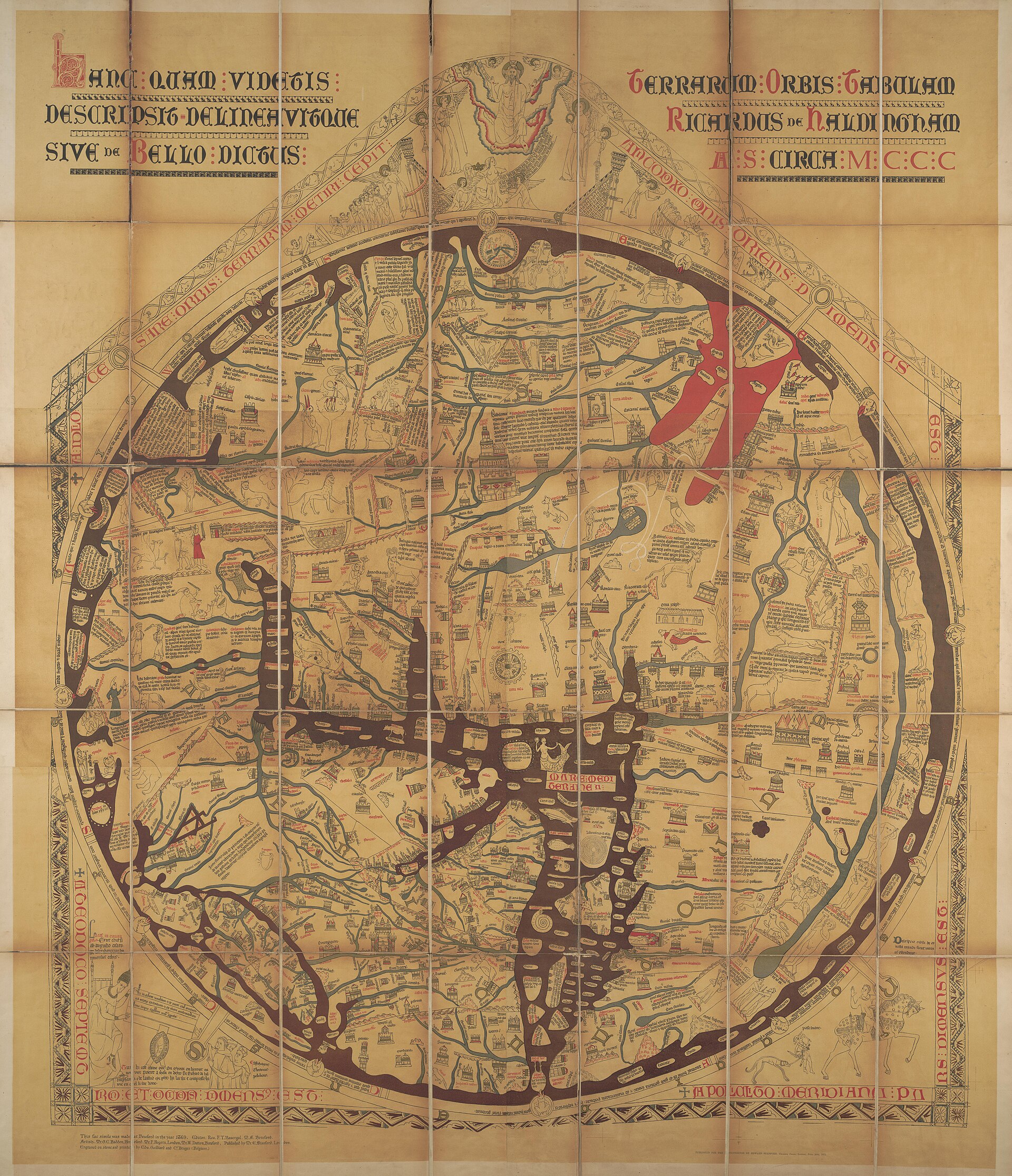
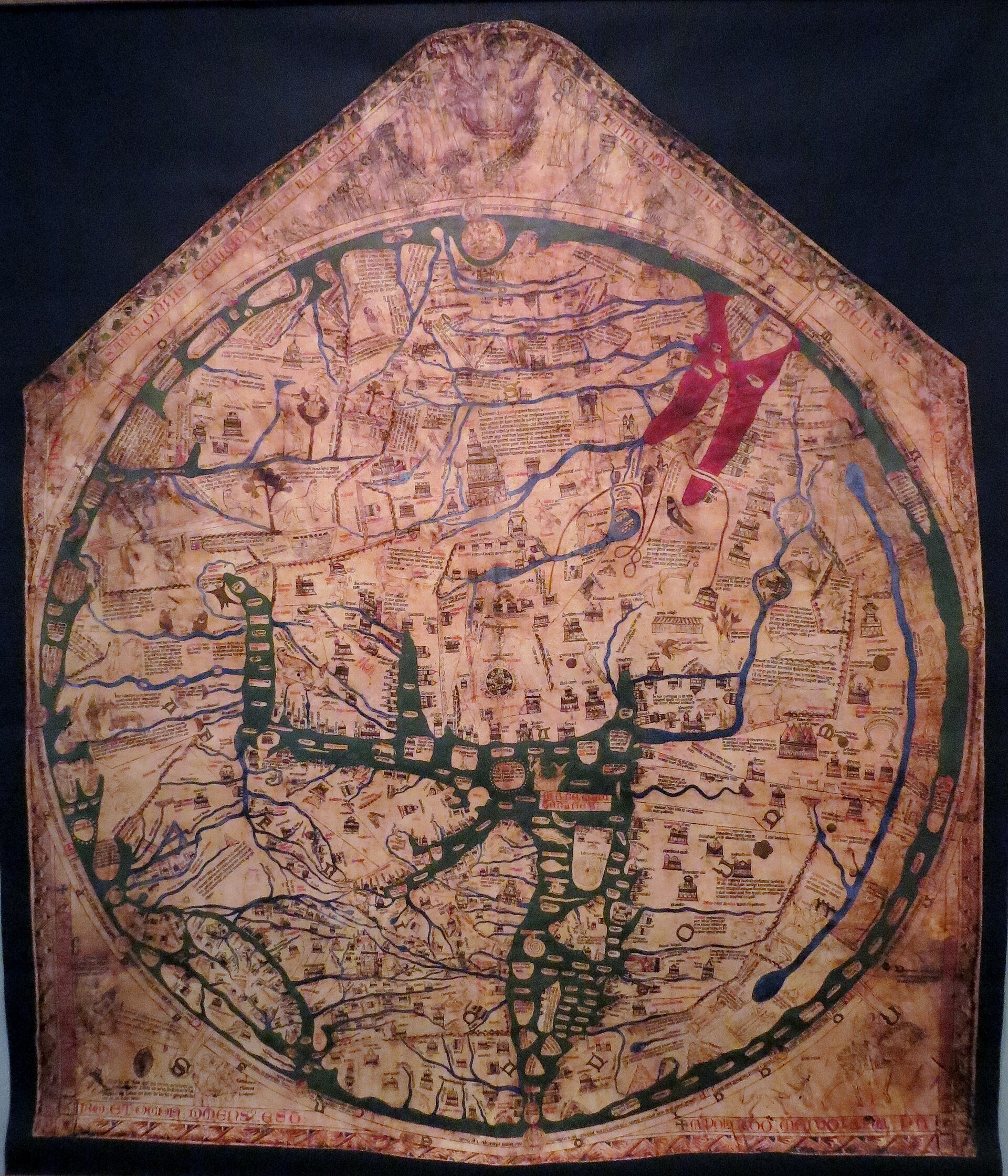
The record in full
Chapter 1What it is
The Hereford Mappa Mundi is a single sheet of vellum, roughly 158 by 133 centimetres by the figure most often published, or 162.6 by 134.6 centimetres by the measurement given in the United Kingdom's...
The Hereford Mappa Mundi is a single sheet of vellum, roughly 158 by 133 centimetres by the figure most often published, or 162.6 by 134.6 centimetres by the measurement given in the United Kingdom's own 2006 nomination of the map to the UNESCO Memory of the World Register - the two figures do not quite agree, and this record cites both rather than picking one silently. Within that sheet a circle about 132 centimetres across contains the map proper: the known world drawn as a disc, Jerusalem fixed at its centre, east at the top, ringed by an outer band of ocean and, beyond the world's edge, a scene of the Last Judgement with Christ enthroned above it. It is, by common agreement among the scholars who have catalogued the surviving corpus of large medieval display maps, the biggest one still in existence.
The map is not a navigational instrument and was never meant to be one. It carries roughly 500 individual images and passages of text: about 420 town views and place symbols, fifteen scenes from the Bible, thirty-three animals, plants, birds and fish, thirty-two peoples of the earth (many of them the monstrous races of classical and medieval ethnography), and five stories drawn from classical mythology. Around the outer edge of the world, at the top, the letters M O R S - Latin for death - are spaced around the Last Judgement roundel, so that a viewer tracing the rim of the earth with their eye is made, without being told to, to read the word for their own mortality. This is a visual encyclopaedia of sacred and secular knowledge built around a map, not a chart for finding a route.
It has hung, with interruptions covered in a later section, in Hereford Cathedral for most of its seven centuries of existence, and it is today displayed in a sealed, environmentally controlled case that is opened for direct inspection only roughly once every two years.
Chapter 2How it was made
The map is drawn in iron gall ink with additions of red, gold, blue and green pigment, on a single prepared skin of vellum - a single animal hide large enough to take the whole design, rather than...
The map is drawn in iron gall ink with additions of red, gold, blue and green pigment, on a single prepared skin of vellum - a single animal hide large enough to take the whole design, rather than sheets joined together. The Red Sea is coloured red, as its name promises; water elsewhere is rendered in green or blue. Gold is used sparingly, for emphasis rather than as a ground.
The sheet has been mounted since the Middle Ages on an oak backboard, and it is the backboard, not the vellum, that has given modern conservators their firmest physical date. Dendrochronological analysis of the oak places the felling of the tree or trees used at around 1295 to 1300, consistent with the palaeographic dating of the text to between about 1290 and 1310. When the digitisation team from Factum Arte carried out a high-resolution 3D scan of the map's surface in January 2013 using a Lucida laser scanner - a non-contact system reading the vellum's relief at a resolution of ten thousand points per square centimetre - they were also able to scan the backboard itself, using the same Lucida system for its flat central section and close-range photogrammetry for its carved decorative edge. Comparing the two surfaces let them match damage and marking across the map and its mount: a pouncing mark, used to transfer a design, sits at the map's exact centre, at Jerusalem, and areas of wear on the vellum correspond to points where it was originally fixed to the board. Lines scored through the depiction of Paris, long assumed to be accidental damage, were shown by the 3D scan to stand proud of the surface, meaning they were cut deliberately rather than by later mishandling - a small but telling correction to how the map's own physical history had been read.
Chapter 3Jerusalem at the centre
The map's organising decision is theological before it is geographical.
The map's organising decision is theological before it is geographical. Jerusalem sits at the exact centre of the disc, not because thirteenth-century Englishmen believed it to be the planet's midpoint in any measurable sense, but because Christian cosmography placed the site of the Crucifixion and Resurrection at the spiritual centre of creation, following a reading of Ezekiel 5:5 ('I have set her in the midst of the nations'). East, not north, is at the top, because east is the direction of Eden and of the rising sun read as a figure for Christ; the map's format is the classic medieval T-O scheme, in which the inhabited landmass is divided by the Mediterranean, the Nile and the Don into Europe, Africa and Asia, arranged around a T inscribed in an O.
Everything else on the map is arranged inside that theological frame. The Garden of Eden appears at the world's eastern extremity, drawn as an island ringed with fire, beyond the reach of ordinary travel. Biblical history is laid across the map's geography rather than confined to a separate register: the route of the Exodus, the wanderings of the Israelites, the site of the Tower of Babel and the story of Noah's Ark are all placed where the map-makers believed the events to have physically occurred. The monstrous races at the edges of the world - the Blemmyae with faces in their chests, the dog-headed Cynocephali, the one-legged Sciapods - are not decoration; they occupy a real place in the period's understanding of the created order, described in classical ethnography and repeated through the medieval encyclopaedic tradition, positioned at the margins of the world precisely because that is where such wonders were believed to belong. The map's message, delivered through cartography rather than through a sermon, is that the whole of created space, from Eden to Judgement, is legible as a single divinely ordered structure, and that a viewer standing before it in Hereford Cathedral could see their own history and their own eventual fate laid into the same picture as the rivers of the earth.
Chapter 4Why it was made, and for whom: the Cantilupe question
Why a cathedral commissioned an object this large and this expensive, and what it was actually for inside the building, is argued rather than known.
Why a cathedral commissioned an object this large and this expensive, and what it was actually for inside the building, is argued rather than known. Thomas de Cantilupe, Bishop of Hereford from 1275, died in 1282 and was buried in the cathedral's north transept; his tomb became the focus of an intense and immediately profitable pilgrimage cult, and he was canonised by Pope John XXII in 1320 after a formal enquiry into reported miracles at the shrine. His successor as bishop, Richard Swinfield, actively promoted the cult and the translation of Cantilupe's remains to an enlarged shrine in 1287.
Dan Terkla, writing in Imago Mundi in 2004, argued that the map was originally displayed in 1287 immediately next to that shrine in the north transept, as part of what he called the Cantilupe pilgrimage complex: a world map placed beside the tomb of a soon-to-be saint, reinforcing the shrine's claim to cosmic as well as local significance and giving pilgrims a devotional object to study while queuing to venerate the relics. Thomas de Wesselow, responding in the same journal in 2013, rejected that specific placement, arguing on the evidence of masonry, recorded metal fixing-points and the alignment of wooden fittings on the back of the map's own central section that it more likely hung on a wall in the south choir aisle, near Cantilupe's tomb but not immediately beside the working shrine itself. The two scholars disagree about the exact wall, not about the general claim that the map's first setting was tied to the Cantilupe cult; this record reports both positions and does not choose between them, since neither has been treated as settled in the literature located for this record. (Note for the editor: both arguments were traced through search-engine summaries of the Imago Mundi articles rather than the full published text, and should be checked against the original journal pieces before either is quoted directly.)
Whatever the precise wall, the map's function inside the cathedral was almost certainly bound up with a shrine promoting sainthood, income and civic prestige all at once - a working piece of religious infrastructure, not a curiosity kept for its own sake.
Chapter 5Who made it: Lincoln, Hereford, and the Richards
For a long time the map's manufacture was assigned to Lincoln, on internal evidence: Lincoln is drawn with a level of topographic detail - a cathedral on a hill above a river, recognisably the city's...
For a long time the map's manufacture was assigned to Lincoln, on internal evidence: Lincoln is drawn with a level of topographic detail - a cathedral on a hill above a river, recognisably the city's own setting - that the map does not extend to any other English location, including Hereford itself, whose cathedral appears to have been added by a different, later hand and with none of Lincoln's particularity. Combined with the Haldingham/Lafford inscription's plausible link to a churchman with a documented Lincoln post (a Richard de Bello held the prebend of Lafford, in Lincolnshire, at Lincoln Cathedral around 1283), this was read as evidence the map itself was made at Lincoln and only later brought to Hereford.
More recent physical evidence points the other way. Analysis of the wood of the map's backboard indicates an origin in or around Hereford rather than Lincolnshire, which - if the board was made for the map rather than acquired separately - argues for local manufacture at Hereford, with the Lincoln detail explained as evidence of the design's sources or its maker's prior career rather than of where the object was physically produced. Scott Westrem, whose 2001 transcription and commentary on the map's legends is the standard scholarly reference for the text (P.D.A. Harvey and Westrem's joint 1996 volume, Mappa Mundi: The Hereford World Map, is the companion standard reference for the map's origins and sources; both are cited here as the acknowledged authorities, though this record was compiled from summaries and library catalogue descriptions of both works rather than a first-hand read of either, and both should be consulted directly by anyone citing this record's account of authorship), has noted that certainty about the place of manufacture has never actually been established despite the long-standing assumption of Lincoln. A further hypothesis - that the inscribed Richard began the design and it passed after his death to a younger relative, a second Richard de Bello, working under the patronage of Bishop Swinfield - has been proposed to reconcile a project too large and detailed for a single hand within a short working life, but it remains a proposal built to fit the surviving evidence rather than a documented sequence of named individuals with dates.
Chapter 6What it copies, and what it does not
The map is very unlikely to be an original invention of its own geography.
The map is very unlikely to be an original invention of its own geography. Its makers drew on the standard medieval encyclopaedic and geographic tradition: chiefly Paulus Orosius's early fifth-century Historiarum adversum paganos libri septem (Seven Books of History against the Pagans), which the map cites directly and which supplied much of its classical place-name geography, alongside the bestiary tradition, the Alexander romance cycle, and biblical geography drawn from the Vulgate and from commentary traditions built on it. The underlying T-O scheme itself traces back through Isidore of Seville and, ultimately, to the diagrammatic world maps found in manuscripts of the Commentary on the Apocalypse by the eighth-century Spanish monk Beatus of Liebana.
The Hereford map is one of a small family of English and Continental large-format mappae mundi built on closely related schemes, and getting this family straight matters for avoiding a specific and well-documented kind of error: mistaking one of these maps for another, or for a smaller and differently-purposed chart entirely. The Ebstorf Map, in a German convent, was considerably larger again than the Hereford map and is known today mainly through photographs, having been destroyed in an Allied bombing raid on Luneburg in 1943. The Duchy of Cornwall map, roughly contemporary with the Hereford map and, when complete, larger still, survives only as a small fragment; it is a wholly separate physical object in a separate collection (the Duchy of Cornwall), not an alternative name for the Hereford map and not a piece of it. The Psalter Map, a much smaller mappa mundi bound into a thirteenth-century psalter now in the British Library, shares the same broad tradition and structure but is a different object again, of a completely different scale and made for private devotional use rather than public display. None of these should be captioned or discussed as though they were the Hereford map, and none of the images in this record's gallery are drawn from any of them.
Chapter 7Reading the margins
The map's roughly one thousand individual legends - the place names, the descriptive captions attached to the animals and peoples, the biblical and mythological tags - have been the subject of...
The map's roughly one thousand individual legends - the place names, the descriptive captions attached to the animals and peoples, the biblical and mythological tags - have been the subject of sustained modern scholarship, of which Westrem's 2001 transcription and translation is the standard point of reference. Reading them correctly is harder than it looks: the map's Africa and Europe are labelled the wrong way round, with the legend for Europe appearing, in red and gold, over what is drawn as Africa, and vice versa. For a long time this was treated simply as an error, evidence that whoever executed the final labelling did not fully understand the geography they were copying.
Marcia Kupfer, in Art and Optics in the Hereford Map: An English Mappa Mundi, c. 1300 (Yale University Press, 2016), has argued instead that the swap is deliberate: an intentional optical device, encoding the reversal that would occur if the map's design were read as though seen in a mirror, rather than a copying mistake. This is an argued reading, not a settled one, and it rests on a broader claim about how sophisticated the map's makers were about optics and image-making generally; this record reports Kupfer's thesis as hers, attributed and dated, not as established fact, and notes for the editor that the claim was traced through a search-engine summary of a published review of the book (the review itself could not be directly retrieved) rather than the book's own text, and should be verified against Kupfer's argument in full before being quoted or paraphrased more tightly than it is here.
Separately from the labelling question, recent technical imaging has added new physical evidence to the reading of the map without needing to resolve the Africa/Europe debate: the 2013 Factum Arte 3D scan found that the depiction of Hereford itself has been almost entirely worn away, flattened by generations of visitors and guides pointing to the spot before the map was placed under glass, though scan data shows faint traces of ink and pigment still present beneath the worn surface. The map's most heavily touched detail is, in other words, also its most damaged, an ordinary and well-documented hazard of centuries of public display rather than a mystery.
Chapter 8Survival: concealment, restoration, war
The map's continuous physical survival, as opposed to its documented history, is thinly recorded for long stretches.
The map's continuous physical survival, as opposed to its documented history, is thinly recorded for long stretches. According to the account given in Wikipedia's article on the map - cited here as a tertiary source that should be replaced with the Cathedral's own archival record before this narrative is treated as final - the map was hidden during the English Civil War of the 1640s, laid beneath the floor of Bishop Audley's Chantry chapel within the cathedral, presumably to protect it (along with other cathedral valuables) from Parliamentarian troops or from being sold off amid the general disruption of church property during the period. It was cleaned and repaired at the British Museum in 1855. During the Second World War it was removed from the cathedral for safekeeping and was not returned to display until 1946.
Small holes in the vellum were patched with replacement parchment in the nineteenth century, coloured to match the surrounding medieval surface closely enough that, according to the 2006 UNESCO nomination for the map (which draws on the Cathedral's own conservation file), they are easy to distinguish from the original only on close inspection, not at a casual glance. As of that 2006 nomination the Cathedral's retained conservator, Christopher Clarkson, inspected the map every two years; no active treatment of the vellum itself was then being carried out beyond monitoring, though removal of the Victorian patches was under consideration if it could be done without further risk to the original surface. Display conditions specified in the Cathedral's own management plan, submitted as part of that nomination, are a constant 17 degrees Celsius, 55 per cent relative humidity, light levels held to 25 lux, and ultraviolet-filtering glass throughout the case - a controlled environment built specifically around this one object.
Chapter 91988: the Dean and Chapter propose a sale
In 1988 the Dean and Chapter of Hereford Cathedral announced their intention to sell the map at auction through Sotheby's.
In 1988 the Dean and Chapter of Hereford Cathedral announced their intention to sell the map at auction through Sotheby's. The stated reason, reported at the time in the Burlington Magazine, was to raise a seven-million-pound endowment intended to secure the cathedral's long-term finances and its wider activities; other accounts describe financial advisers as having recommended an endowment of at least six million pounds against a long-term structural deficit in the diocese's finances, a figure close enough to the seven-million target that this record treats the two as compatible rather than contradictory, while noting that neither the exact advisers' report nor Sotheby's own valuation of the map has been located in the sources consulted for this record. The Bishop of Hereford defended the decision on the grounds that the cathedral was, in his words as reported, 'a living part of the Church and not a museum.' The map had been shown publicly, shortly before the sale was announced, in the Royal Academy's Age of Chivalry exhibition over the winter of 1987-88, and was returned to Hereford not long before the sale plan became public.
The announcement provoked an immediate and sustained public and parliamentary reaction. The matter was debated in the House of Commons on 5 December 1988, where the Minister for the Arts, Richard Luce, told the House he had 'no shadow of doubt about the importance of this object to our heritage' and called for 'an effective partnership between the public and the private sectors' to keep the map in Britain, with the National Heritage Memorial Fund positioned as the likely lead vehicle for any rescue. The House of Lords debated the same question the following day, 6 December 1988, and again on 21 December 1988, where peers including Lord Blake were openly sceptical of the Chapter's position, with Blake calling the sale 'the lazy way out' and noting that other English cathedrals with comparably significant treasures - Lincoln, Salisbury, Winchester among them - had managed comparable financial pressure without resorting to selling their most important single object. Ownership of the map itself briefly became a point of confusion inside the Lords debate: Baroness Trumpington first told peers that the map belonged to the nation, then corrected herself once better information reached her, confirming that the Dean and Chapter held clear legal title and could, in principle, sell it.
Chapter 101989: the rescue
Through the early months of 1989 the National Heritage Memorial Fund worked to assemble an alternative to auction.
Through the early months of 1989 the National Heritage Memorial Fund worked to assemble an alternative to auction. On 17 February 1989 the Fund presented the Dean and Chapter with a formal proposal: a grant of two million pounds from the Fund itself, offered on the express understanding that a public appeal would be launched to raise a further, similar sum, together with a separate offer of one million pounds from Mr J. Paul Getty - later Sir Paul Getty KBE, the American-born, British-naturalised collector and philanthropist whose other gifts to British cultural institutions eventually totalled well over one hundred million pounds, including a fifty-million-pound gift to the National Gallery. As reported in the House of Commons debate of 20 March 1989, this put roughly five million pounds on the table against the seven million the Chapter had originally said it needed from a sale - two million confirmed from the Fund, one million confirmed from Getty, and a further two million anticipated, but not yet raised, from public subscription. (This record cannot confirm, from the sources located, either the amount actually collected by that public appeal or whether Getty's one million pounds came from him personally or through the J. Paul Getty Jr General Charitable Trust that he later endowed; this is flagged for the editor rather than resolved by assumption.)
The Dean and Chapter withdrew the map from public auction at the end of February 1989, before the Fund's package had been fully agreed, and for a period pursued their own alternative: a proposal, reported to the Commons on 20 March 1989, to raise money by selling shares in a company at one thousand pounds each, with each shareholder to receive a replica of the map and the Dean and Chapter retaining fifty per cent of the stock. That share scheme was not proceeded with. Instead, the Fund's grant, Getty's gift and the resulting public appeal were channelled through a newly created charity, the Hereford Mappa Mundi Trust, formed in 1989 specifically to own the map (and, with it, the Cathedral's separate Chained Library) on terms that took it permanently out of the Chapter's power to sell.
Using the Office for National Statistics Retail Prices Index (RPI, base year 1987) as the method, and its Q4 2025 index value of approximately 407 against a base of 100, one pound in 1988 is worth very roughly four times as much in 2025-26 terms. On that basis the Chapter's original seven-million-pound target equates, very approximately, to somewhere in the region of twenty-eight million pounds today, and the roughly five-million-pound rescue package assembled by February 1989 to somewhere in the region of twenty million pounds - figures given here as an order of magnitude, using a named and reproducible method, not as a precise modern valuation.
Chapter 11After the rescue: a building for the map
The Trust's money did not simply sit as an endowment; it was used, together with further fundraising through the 1990s, to build a permanent home for the map and the Chained Library.
The Trust's money did not simply sit as an endowment; it was used, together with further fundraising through the 1990s, to build a permanent home for the map and the Chained Library. Designed by the architect William Whitfield, the new library building was constructed in the south-east corner of the Cathedral close and opened on 5 May 1996, in a ceremony performed by Queen Elizabeth II. The building went on to win the Royal Fine Art Commission's Building of the Year award in 1997. The map has been displayed there, in the environmentally controlled case described above, ever since, alongside the Cathedral's chained library of some 1,500 books - one of the largest surviving library collections still kept in its historic chained arrangement anywhere in the world.
The legal position established in 1989 has held: as of the 2006 UNESCO Memory of the World nomination for the map, and so far as this record has been able to confirm, the Hereford Mappa Mundi Trust remains the map's owner, the Dean and Chapter remain its delegated custodians and exhibitors, and the Trust's own deed provides that the map would pass to the British Library, London, rather than back to the Chapter's control, if the Trust were ever wound up. The 1988-89 episode is, in that specific sense, still doing legal work today: it did not just prevent one sale, it restructured who is legally capable of proposing another.
Chapter 12Digitisation and where the research stands now
The map has been the subject of sustained non-invasive technical documentation over the past two decades.
The map has been the subject of sustained non-invasive technical documentation over the past two decades. Factum Arte, commissioned by the Mappa Mundi Trust, carried out the first high-resolution 3D scan of the map's surface in January 2013 using a Lucida laser scanner, working in 48 by 48 centimetre sections at a resolution of ten thousand points per square centimetre; the Factum Foundation's team returned between 2016 and 2018 to add colour documentation, using hundreds of high-resolution macro photographs stitched into gigapixel composite images of the map's current, aged surface, and to scan the backboard using the same Lucida system for its flat area and photogrammetry for its carved edge. The Hereford Map is also included, with high-quality 2D and 3D scan data, in the Virtual Mappa project, a IIIF-based digital initiative bringing together multiple medieval mappae mundi for open scholarly access and comparison.
On the interpretive side, the map remains an active subject of argument rather than a closed file: Terkla's and de Wesselow's competing claims about its original position inside the cathedral, discussed above, were both published within the last two decades; Kupfer's 2016 reading of the Africa/Europe label swap as a deliberate optical device is more recent still and, on the evidence available to this record, has not displaced the older reading of the swap as an error so much as reopened the question. This is not a map whose meaning was settled by Victorian antiquarians and left alone since; each generation of technical imaging and each new monograph has changed some specific claim about it, sometimes reversing a reading (the Paris damage, previously read as accidental) and sometimes contesting one that had never been seriously challenged before (the Africa/Europe labels).
Chapter 13What is still unresolved
Several questions about this object have no agreed answer in the material located for this record, and are recorded here as open rather than quietly smoothed over.The identity of 'Richard of...
Several questions about this object have no agreed answer in the material located for this record, and are recorded here as open rather than quietly smoothed over.
The identity of 'Richard of Haldingham and Lafford' - whether he was a single named individual, a workshop supervisor, a patron rather than a maker, or a composite of more than one Richard across a working life too long for the map's apparent production window - remains the central open question, and it is the one the map itself raises through its own inscription rather than one imposed on it by later scholars. Where inside the cathedral the map originally hung, and what specific liturgical or devotional purpose that placement served, is argued between at least two named scholars on the basis of physical fixing evidence that has been read two different ways. Whether the map was physically produced at Hereford or at Lincoln, and what that would mean for how its Lincoln-detailed geography should be read, is not settled by the backboard wood evidence alone. Whether the reversed Africa and Europe legends are a deliberate mirror-image device or a straightforward copying error is a live scholarly disagreement rather than a solved puzzle. And two much more recent, narrower gaps remain in the documentary record assembled here specifically: the actual sum raised by the 1989 public appeal that was meant to match the National Heritage Memorial Fund's two million pounds has not been found in the sources consulted, and neither has Sotheby's own valuation of the map before the sale was withdrawn.
The artist
Richard of Haldingham and Lafford (possibly identical with, or connected to, a Richard de Bello; identity disputed)
Almost nothing about the person or persons named in the map's own inscription can be treated as established biography. What exists is an Anglo-Norman verse asking prayer for one 'Richard of Haldingham and Lafford, who made and laid it out,' and a set of scholarly attempts, none of them conclusive, to attach that name to a documented individual with a traceable career. This dossier reports those attempts as arguments, graded by how firmly evidenced each is, rather than assembling them into a single confident biography that the surviving evidence does not support.
Related works
| Work | Relation | Where it is |
|---|---|---|
| Duchy of Cornwall map (fragment) Unknown | A separate, roughly contemporary large English mappa mundi, of a similar T-O type and, when complete, larger than the Hereford map Only a small fragment survives. This is a distinct physical object in a distinct collection, not another name for the Hereford map and not part of it; caution against conflating the two is explicit in this record's brief. | Duchy of Cornwall collection; fragment held at Berkhamsted Castle / Duchy of Cornwall archives |
| Ebstorf Map Unknown, associated with Ebstorf convent, Germany | A larger mappa mundi of the same broad tradition, drawn at a similar date Destroyed in an Allied bombing raid on Luneburg during the Second World War. Comparisons between it and the Hereford map rely on photographic records, not on the lost original. | Formerly Kloster Ebstorf, Germany; destroyed 1943, known today from photographs and facsimiles |
| Psalter World Map Unknown | A much smaller mappa mundi of the same broad cartographic tradition, bound into a devotional psalter Made for private devotional use at a fraction of the Hereford map's scale; a different object entirely, sharing tradition rather than identity with it. | British Library, London (Add. MS 28681) |
| Sawley Map Unknown, associated with Sawley Abbey | An earlier, smaller mappa mundi within the same T-O and encyclopaedic tradition Cited in the scholarship as part of the same family of English display and manuscript maps that the Hereford map's makers drew upon or paralleled. | Corpus Christi College, Cambridge |
| Beatus of Liebana world maps Various, following the Beatus manuscript tradition | Earlier diagrammatic world maps within the Commentary on the Apocalypse tradition, an acknowledged root of the T-O scheme used at Hereford Source tradition rather than direct model; cited for the structural lineage of the T-O format, not as a claimed direct exemplar for the Hereford map specifically. | Various manuscripts, chiefly in Spanish and French collections |
Open questions
- Who was 'Richard of Haldingham and Lafford', and does the map's inscription name its designer, its scribe, or its patron rather than its maker in any modern sense?
- Was the map originally displayed beside St Thomas Cantilupe's shrine in the north transept (Terkla's argument) or on a wall in the south choir aisle nearer his tomb (de Wesselow's argument)? The two scholars disagree on the physical evidence.
- Was the map physically produced at Lincoln, as its detailed depiction of that city long suggested, or at Hereford, as more recent backboard wood analysis indicates - and if Hereford, how should the Lincoln detail be explained?
- Is the reversal of the Africa and Europe legends a deliberate optical device encoding a mirror-image reading, as Marcia Kupfer has argued, or a straightforward copying error, as earlier scholarship assumed? The disagreement is unresolved in the material located for this record.
- What did the map's lost triptych wings, recorded only in John Carter's 1784 drawing, actually depict, and when and how were they lost? No other record of their content has been located.
- How much did the 1989 public appeal that was meant to match the National Heritage Memorial Fund's two million pounds actually raise? The figure has not been found in the sources consulted for this record.
- What valuation, if any, did Sotheby's place on the map before the 1988 sale was announced and then withdrawn in February 1989? No published estimate has been located.
Questions about this object
What is Hereford Mappa Mundi?
Hereford Mappa Mundi is a map, dated c. 1300 (dated on palaeographic and art-historical grounds to between c. 1290 and c. 1310; the oak backboard is dendrochronologically dated to trees felled around 1295-1300). Medium: Iron gall ink, pigment (red, gold, blue and green) and gold leaf on a single sheet of vellum, mounted since the Middle Ages on an oak backboard.
Who made Hereford Mappa Mundi, and is the attribution settled?
The attribution to Richard of Haldingham and Lafford (identity disputed) is recorded here as disputed. The map carries no signature in the modern sense. Its only claim to authorship is an Anglo-Norman French verse inscription in the lower left corner asking those who see it to pray for 'Richard of Haldingham and Lafford, who made and laid it out' (fet e compasse). Scholars have never agreed on who this Richard was, whether the inscription names a designer, a supervising scribe, or a patron who commissioned and gave the map rather than drew it, or whether he produced the design himself or adapted an earlier exemplar. The United Kingdom's own 2006 nomination of the map to the UNESCO Memory of the World Register states the problem plainly: it is not clear who he was, or whether he created the Hereford map or only its exemplar. The strongest identification on record links him to a Richard de Bello, prebendary of Lafford (Sleaford) at Lincoln Cathedral around 1283, who later held office under the Bishop of Hereford; a further hypothesis holds that the design and patronage involved more than one person, including Bishop Richard Swinfield of Hereford. None of this is settled, and this record treats the name as a documented inscription rather than a documented biography.
Where is Hereford Mappa Mundi now?
Hereford Cathedral, Hereford, England, in the purpose-built Mappa Mundi and Chained Library exhibition. Inventory number No public catalogue or accession number is published; the map is not part of a numbered museum collection. Last confirmed 15 August 2026. Owned by the Hereford Mappa Mundi Trust, a registered charity created in 1989 specifically to hold the map and the Cathedral's Chained Library; the Trust's deed provides that ownership passes to the British Library, London, if the Trust is ever dissolved. The Trust delegates day-to-day care and public display to the Dean and Chapter of Hereford.
What is still unknown about Hereford Mappa Mundi?
Who was 'Richard of Haldingham and Lafford', and does the map's inscription name its designer, its scribe, or its patron rather than its maker in any modern sense?
Sources
- 1Hansard, House of Commons, 'Mappa Mundi', 5 December 1988. api.parliament.uk/historic-hansard/...
- 2Hansard, House of Lords, 'The Mappa Mundi', 6 December 1988. api.parliament.uk/historic-hansard/...
- 3Hansard, House of Lords, 'Historic Buildings and Treasures', 21 December 1988. api.parliament.uk/historic-hansard/...
- 4Hansard, House of Commons, 'Mappa Mundi', 20 March 1989. hansard.parliament.uk/Commons/...
- 5The Burlington Magazine, 'Sic transit mappa mundi?' (contemporary account of the 1988-89 sale crisis). burlington.org.uk/archive/...
- 6United Kingdom Permanent Delegation to UNESCO, nomination of the Hereford Mappa Mundi to the Memory of the World Register, Ref N 2006-32, 31 March 2006 (compiled with the owning Trust and the Cathedral custodian). media.unesco.org/sites/...
- 7P.D.A. Harvey and Scott D. Westrem, Mappa Mundi: The Hereford World Map (Hereford Cathedral / British Library, 1996) - standard reference for the map's origins and sources; bibliographic details confirmed via library catalogue and publisher records, not a first-hand reading of the book. archive.org/details/...
- 8Scott D. Westrem, The Hereford Map: A Transcription and Translation of the Legends with Commentary, Terrarum Orbis 1 (Brepols, 2001) - standard reference for the map's texts; bibliographic details confirmed via publisher and journal review records, not a first-hand reading of the book. brepols.net/products/...
- 9Dan Terkla, 'The Original Placement of the Hereford Mappa Mundi', Imago Mundi 56.2 (2004) - argued position on original display location; accessed via secondary search-engine summary, not the full published article. Flagged for verification against the original. tandfonline.com/doi/...
- 10Thomas de Wesselow, 'Locating the Hereford Mappamundi', Imago Mundi 65.2 (2013) - counter-argument on original display location; accessed via secondary search-engine summary, not the full published article. Flagged for verification against the original. tandfonline.com/doi/...
- 11Marcia Kupfer, Art and Optics in the Hereford Map: An English Mappa Mundi, c. 1300 (Yale University Press, 2016) - argument that the Africa/Europe legend swap is a deliberate mirror-image device; accessed via secondary search-engine summary of a published review (the review itself, at CAA Reviews, returned an access error on direct fetch). Flagged for verification against the book itself. caareviews.org/reviews/...
- 12Factum Foundation, 'The Hereford Mappa Mundi' (digitisation project page, covering the 2013 and 2016-2018 Factum Arte scanning campaigns). factumfoundation.org/our-projects/...
- 13The Hereford Mappa Mundi Trust, 'About the Trust'. themappamundi.co.uk/about-the-trust.php
- 14Wikipedia, 'Hereford Mappa Mundi'. en.wikipedia.org/wiki/...
- 15Wikipedia, 'National Heritage Memorial Fund'. en.wikipedia.org/wiki/...
- 16Wikipedia, 'John Paul Getty Jr.'. en.wikipedia.org/wiki/...
- 17Daniel Crouch Rare Books, 'The Hereford Mappa Mundi' (dealer reference page, dimensions and general description). crouchrarebooks.com/maps/...
- 18Wikimedia Commons, file description page, File:Hereford-Karte.jpg. commons.wikimedia.org/wiki/...
- 19Wikimedia Commons, file description page, File:Hereford mappa mundi 14th cent repro IMG 3895.JPG (uploader's own description identifies the subject as a 'Replica'). commons.wikimedia.org/wiki/...
- 20Wikimedia Commons, file description page, File:Hereford Mappa Mundi 1300.jpg. commons.wikimedia.org/wiki/...
- 21Wikimedia Commons, file description page, File:Triptych containing the Hereford Mappa Mundi.png (John Carter, 1784, British Library Add. MS 29942, fol. 148r). commons.wikimedia.org/wiki/...
- 22Wikimedia Commons, file description page, File:Hereford map facsimile by Havergal 1872.jpg. commons.wikimedia.org/wiki/...
- 23UK Retail Prices Index (RPI) historical series, used as the method for the period-value conversion in this record's account of the 1988-89 figures. in2013dollars.com/UK-inflation
- 24Just History Posts, 'Historical Objects: The Hereford Mappa Mundi'. justhistoryposts.com/2022/...


Last verified · Published
Change log
15 August 2026 - Record created at the house standard: researched narrative, technical evidence, maker dossier, graded provenance chain, prices with hammer and premium separated, related works, open questions and sources.