The Genoese World Map of 1457
Anonymous Genoese cartographic workshop · 1457
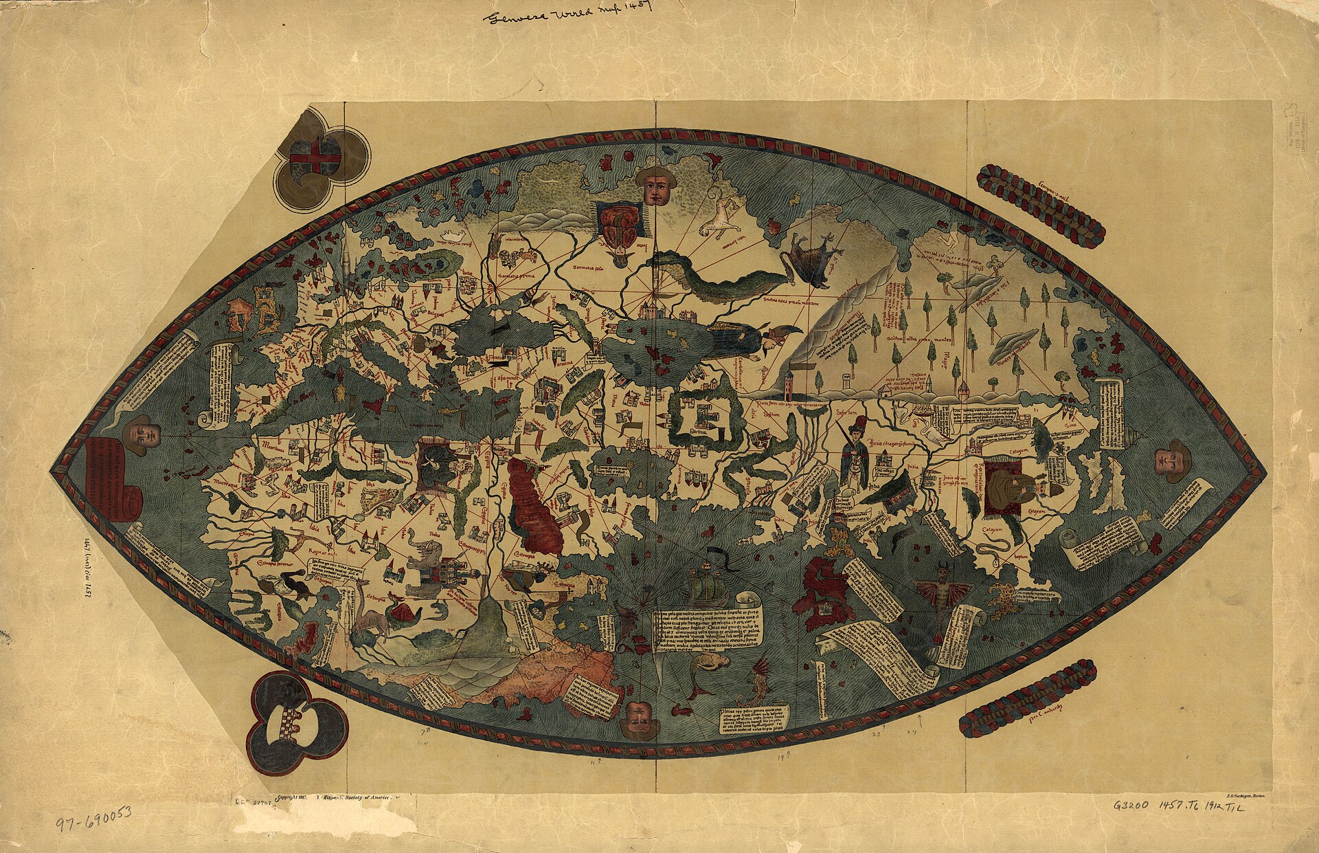
Edward Luther Stevenson's 1912 facsimile plate, reproduced from photographic negatives made in 1905 by the staff photographer of the Istituto Geografico Militare with the stated aim of fidelity to the original 'in every detail.' This is a photographic facsimile of the parchment held at the Biblioteca Nazionale Centrale di Firenze, not a hand-traced or artistic redrawing; verified against Stevenson's own account of the reproduction process before use.
| Artist | Anonymous Genoese cartographic workshop |
|---|---|
| Date | 1457 |
| Medium | Ink and tempera pigment in six colors, with gold-powder highlighting, on a single parchment sheet |
| Dimensions | 39.5 x 79.5 cm per the Biblioteca Nazionale Centrale's own 'Tesori svelati' catalogue entry and the Encyclopaedia of Portuguese Expansion (Universidade Nova de Lisboa); other secondary sources and later facsimile editions give different figures (75 x 37 cm; 82 x 41 cm) not reconciled in the sources consulted for this record, and possibly reflecting facsimile-sheet sizes rather than the parchment itself |
| Where it is now | Biblioteca Nazionale Centrale di Firenze (National Central Library of Florence), Florence, Italylast confirmed |
| Inventory number | Portolano 1, per the library's own 'Tesori svelati' historical-catalogue entry and the Encyclopaedia of Portuguese Expansion. Edward Luther Stevenson's 1912 study instead records the shelfmark then in use, 'Sezione Palatina No. 1, Planisfero Mediceo' - the map's older number under the Grand-Ducal Palatine Library before that library's later reorganisation within the Biblioteca Nazionale Centrale. |
| Attribution | UnknownNothing on the sheet names a maker. Full note |
| Object type | Map |
| Period | Italian (Genoese), mid-fifteenth century |
| Cases | Has a provenance gap |
| Inscriptions | A marginal inscription, translated by the Encyclopaedia of Portuguese Expansion as 'This is the true description of the cosmographers, drawn according to nautical maps, and rejecting frivolous and fantastic tales.' The sheet carries approximately 305 toponyms and 56 cartouches of explanatory text in a simplified littera textualis book hand, plus the coats of arms of the Republic of Genoa and the Spinola family. |
| Owners on record | 4 links3 documented, 1 unknown |
| Sources | 15 cited |
About this record Last verified · 15 sources cited · Change log
On this page 9 sections
ContentsClose
An anonymous world map on a single sheet of parchment, dated 1457 and named for the coat of arms of the Republic of Genoa and the Spinola family that appear on it, though the toponyms are lettered in Castilian orthography and nothing on the sheet names a draftsman. It sets a hybrid, almond-shaped image of the known world, part portolan chart and part Ptolemaic projection, against a Mediterranean drawn with navigational precision and an East and South Asia drawn from Ptolemy, from Arabic geography, and from the eyewitness account of the Venetian traveler Niccolo de' Conti as taken down in 1444 by the humanist Poggio Bracciolini.
It has belonged to Florentine princely and state collections since at least the seventeenth century, when it hung in the Uffizi's Stanza delle matematiche among the Medici's scientific instruments, and it has been at the Biblioteca Nazionale Centrale di Firenze, under one shelfmark or another, since that library's formation. Since the 1960s a genre of pseudo-historical writing about supposed pre-Columbian Chinese world voyages, of which Gavin Menzies's 1421: The Year China Discovered the World is the best-known modern example, has treated maps of exactly this kind - unexpectedly detailed, unexpectedly early - as proof of secret voyages for which no other record exists. This record sets out what is actually documented about how the map's Asian and African content reached Genoa, and why the documented paper trail leaves no gap for a hidden voyage to fill.
A search of Menzies's own book text for any reference to this specific map returned nothing; the record notes that finding rather than repeating an unverified claim of citation.
Provenance
Each link is graded. Documented: a cited source supports it. Disputed: the identification is argued but not established. Unknown: no owner for that span, and the gap is not smoothed into a narrative. The grades in the glossary.
- 1457 - 17th centuryUnrecordedunknown
No source consulted for this record documents where the sheet was, or in whose hands, between its execution in 1457 and its first documented appearance in the Medici collections. A gap of roughly a century and a half is simply unaccounted for.45
- by 17th century -Medici grand-ducal collectiondocumented
By the seventeenth century the sheet was among the Medici collections and was displayed in the Stanza delle matematiche of the Uffizi Palace in Florence, alongside the family's scientific instruments.4
- 17th century - 1861Biblioteca Palatina, Florence (Grand-Ducal, later Lorraine, library)documented
The map passed into the custody of the Palatine Library, the Medici and then Lorraine grand-ducal library, where it was catalogued as 'Sezione Palatina No. 1, Planisfero Mediceo' - the shelfmark Stevenson still records in 1912. The exact date this transfer occurred, as distinct from the map's display at the Uffizi, is not given in the sources consulted.3513
- 1861 - presentBiblioteca Nazionale Centrale di Firenzedocumented
In 1861 the Biblioteca Palatina merged with the Biblioteca Magliabechiana to form the library that was renamed the Biblioteca Nazionale Centrale di Firenze by 1885. The map passed to the new institution with the rest of the Palatine holdings; Stevenson's 1912 study still cites the old Palatina number, indicating recataloguing under the current mark 'Portolano 1' happened at some point after 1912.4513
Technical evidence
| Attribution note | Nothing on the sheet names a maker. The coat of arms of the Republic of Genoa and of the Spinola family identify a Genoese context of patronage or ownership, which is why the map carries the name it does, but that is a mark of sponsorship, not a signature. The Biblioteca Nazionale Centrale's own catalogue entry and the 2008 facsimile commentary by Angelo Cattaneo describe the toponyms as written in Castilian orthography, and propose that the drafting hand, or at least the scribe who lettered the place names, trained or worked in Castile rather than in Genoa itself. The finished object required more than one set of hands: a cartographer for the coastlines, rhumb network and coordinate grid, and a separate miniaturist for the heraldic banners, ships, sea creatures and gold-powder highlighting. |
|---|---|
| Support | A single sheet of parchment.5 |
| Dimensions | 39.5 x 79.5 cm per the Biblioteca Nazionale Centrale's own catalogue and the Encyclopaedia of Portuguese Expansion. Other secondary sources and facsimile-edition listings give 75 x 37 cm or 82 x 41 cm; these figures are not reconciled in the sources consulted and may describe facsimile sheets rather than the original.457 |
| Palette and highlighting | Six colors with manual retouching, plus gold-powder highlighting on heraldic banners and other decorative elements.5 |
| Script and content count | Approximately 305 toponyms and 56 explanatory cartouches, lettered in a simplified littera textualis book hand.5 |
| Format | An oval or almond-shaped world image set on the rectangular sheet, combining a portolan-chart rhumb-line network over the Mediterranean and Atlantic coasts with Ptolemaic coordinates for more distant regions.46 |
| Heraldry | The coat of arms of the Republic of Genoa and of the Spinola family appear on the sheet, identifying Genoese patronage or ownership rather than necessarily the cartographer's own origin.59 |
| Historic mounting | At some point before the twentieth century the parchment was mounted on four hinged boards, about half an inch thick, allowing it to be folded rather than kept flat - described by Stevenson in 1912 as 'very old' mounting already causing rubbing damage between the panels.3 |
| Condition as recorded in 1912 | Described as poorly preserved: pigment brilliant in places and almost entirely lost in others, with rubbing between the folded panels the main cause; most toponyms legible, some with difficulty, a few illegible. No later conservation record was found.3 |
Images
The record in full
Chapter 1What it is
A single sheet of parchment, roughly 39.5 by 79.5 centimeters, carrying a world image drawn inside an almond or oval outline rather than the rectangular frame of a working sea chart.
A single sheet of parchment, roughly 39.5 by 79.5 centimeters, carrying a world image drawn inside an almond or oval outline rather than the rectangular frame of a working sea chart. The Mediterranean, Black Sea and Atlantic coasts are drawn with the precision of a portolan chart, laced with color-coded rhumb lines radiating from compass points, while the more distant regions - sub-Saharan Africa, South and East Asia - are drawn schematically from written and secondhand sources rather than from direct survey.
It carries roughly 305 place names and 56 explanatory cartouches in a simplified gothic book hand, the coat of arms of the Republic of Genoa, and the arms of the Spinola family, a leading Genoese merchant house. It is a display object rather than a chart meant to go to sea: too small, too decorative, and built around an outline shape that a working navigator's chart never uses.
Chapter 2How it was made
The Biblioteca Nazionale Centrale's own catalogue description gives the palette as six colors with manual retouching, with gold powder applied for the heraldic banners and other highlights - work...
The Biblioteca Nazionale Centrale's own catalogue description gives the palette as six colors with manual retouching, with gold powder applied for the heraldic banners and other highlights - work distinct enough from the linework that the library's cataloguers describe a cartographer's hand for the coastlines, coordinate grid and rhumb network, 'assisted by a miniaturist and possibly a scribe' for the toponyms, cartouches, ships, sea creatures and city vignettes.
That division of labor is ordinary for an ambitious mid-fifteenth-century cartographic commission: the geometry and the decoration were not necessarily the same person's work, and nothing on the sheet identifies either hand. What the object insists on, in its own marginal inscription, is method rather than authorship: it describes itself, in the Encyclopaedia of Portuguese Expansion's translation, as 'the true description of the cosmographers, drawn according to nautical maps, and rejecting frivolous and fantastic tales' - a claim to have used real charts and rejected fable, made by a cartographer who otherwise says nothing about who he was.
Chapter 3A Genoese object with a Castilian hand
The map is called Genoese because of the arms on it, not because anyone has identified a Genoese cartographer.
The map is called Genoese because of the arms on it, not because anyone has identified a Genoese cartographer. The toponyms, according to the library's own catalogue notes and to Angelo Cattaneo's 2008 facsimile commentary, are lettered in Castilian orthography, which points toward a draftsman or scribe trained in the Iberian tradition working for a Genoese patron, rather than a native Genoese hand. Genoa and Castile were bound tightly in exactly this period by trade, banking and the transfer of nautical expertise, so a Castilian-trained cartographer producing a prestige object for Genoese patrons is unsurprising, but it means the map's name and its actual authorship point in two different directions, and this record keeps that distinction rather than collapsing it.
Nothing else is attributed to whoever made it. Unlike Piri Reis, who names himself and lists his sources, or Fra Mauro, a named Camaldolese monk with a documented workshop, this map's maker or makers have no other surviving work and no biography to reconstruct. The map is a singleton, and this record treats it as one rather than inventing a personality for an anonymous hand.
Chapter 4Reading the world it drew
The map's synthesis is documented rather than mysterious.
The map's synthesis is documented rather than mysterious. Analysis by cartographic historians finds that roughly 87 percent of its content for regions beyond direct European knowledge is drawn from Claudius Ptolemy's Geographia, translated into Latin by Jacopo Angelo di Scarparia in 1406 and rapidly influential in humanist Florence. The Mediterranean and northern European coastlines instead follow the portolan-chart tradition built up by generations of working navigators. For sub-Saharan Africa the cartographer drew on Isidore of Seville's Etymologiae and on Arabic geography associated with al-Idrisi, filtered through the same channels that fed other mid-century Italian mapmakers.
For India and Southeast Asia, the map's most striking source is the account of the Venetian merchant-traveler Niccolo de' Conti, who spent roughly twenty-five years traveling through the Middle East, India and Southeast Asia before returning to Venice in 1439. On his return he dictated his account to the humanist Poggio Bracciolini, secretary to Pope Eugene IV, who set it down in 1444 as Book IV of his De varietate fortunae. That account, not yet in print in 1457 but already circulating in manuscript in humanist circles, is the documented route by which South and East Asian place names and descriptions reached this sheet - the same account that, independently, also shaped the roughly contemporary Fra Mauro map in Venice. Marco Polo's much older thirteenth-century account is a secondary influence behind some of the map's Asian material, alongside Conti's newer and more detailed reporting.
The result includes at least one clearly anachronistic detail noted by multiple commentators: a three-masted European-style ship drawn in the Indian Ocean, a type of vessel that had not yet sailed there in reality, alongside sea monsters reflecting ordinary mid-century interest in the exotic edges of the known world. Both are decoration built on top of a documented information base, not evidence of any voyage that actually happened.
Chapter 5The almond and what it does not show
The map's outline is not a working chart's rectangle but an oval, sometimes described as an eye or almond shape.
The map's outline is not a working chart's rectangle but an oval, sometimes described as an eye or almond shape. The historian of cartography David Woodward classed the map generally as a 'transitory' mappamundi, synthesizing medieval mappae mundi, portolan charts and Ptolemaic geography into one hybrid image - a description of its content rather than an argument about the shape itself. Separately, commentary connecting the oval outline to the mandorla, the almond-shaped halo surrounding Christ and the Virgin in medieval religious art, has been proposed as a reading of the frame; that connection rests on the resemblance between shapes and is presented here as a proposal, not a documented intention, since no source consulted attributes it to a contemporary statement about this specific map.
What is a documented, checkable observation is what the map does not do. It has no Garden of Eden, no centered Jerusalem, and no divine figure presiding over the frame - the standard furniture of an explicitly religious medieval mappamundi. Whatever the oval outline is doing, the map's actual content is oriented toward navigation, trade and reported geography rather than toward salvation history, and that ordinary, secular emphasis is itself worth stating plainly rather than dressing the object up with a hidden program it does not carry.
Chapter 6The claim that will not die
Since the 1960s, and with particular force since Gavin Menzies's 2002 book 1421: The Year China Discovered the World, a genre of popular pseudo-history has argued that European maps showing...
Since the 1960s, and with particular force since Gavin Menzies's 2002 book 1421: The Year China Discovered the World, a genre of popular pseudo-history has argued that European maps showing unexpectedly early or unexpectedly detailed knowledge of Africa's circumnavigability or of East and South Asian geography must derive from secret Chinese voyages - most often the treasure-fleet expeditions of the admiral Zheng He - rather than from the documented European channels historians actually trace. Maps of exactly this map's type, precocious and hard to place at first glance, are the natural target for that argument.
This record checked the claim directly rather than repeating it. A full-text search of Menzies's own book, as archived, returns no occurrence of the word 'Genoese' anywhere in it, and no source consulted for this record - including the most substantial scholarly rebuttal of Menzies's thesis, the historian Robert Finlay's 2004 review in the Journal of World History - names this specific map as one of Menzies's exhibits. This record therefore does not repeat the unverified premise that Menzies cited this map by name; if a specific page reference surfaces later, it belongs here with a citation, not before.
What can be stated with confidence is the general and well-documented rebuttal of the reasoning this genre applies to maps like this one. Finlay's review shows that Menzies's chronology for a supposed Chinese circumnavigation - a claimed 1421-1423 gap in the documented itinerary of Zheng He's fleets - does not exist in the Ming naval record he is working from, that Menzies's own reproductions of source maps sometimes directly contradict the claims he builds on them, and that the argument throughout is circular: maps are read as proof of voyages that are themselves inferred only from the maps. Applied to this object, the actually documented explanation for its precocious Asian and African content is not a hidden voyage but a fully named and dated chain: Ptolemy's Geographia in its 1406 Latin translation, Arabic geography transmitted through Idrisi and Isidore of Seville, and Niccolo de' Conti's firsthand account as taken down by Poggio Bracciolini in 1444. Every link in that chain has a name, a date and a surviving text. A hidden Chinese source is not required to explain anything on this sheet, because nothing on this sheet is left unexplained by the sources that are already known.
Chapter 7From the Uffizi's mathematics room to the Palatine shelf
The map's institutional history is continuous rather than dramatic, and that continuity is itself worth recording because so much of this publication's other material concerns objects that were lost...
The map's institutional history is continuous rather than dramatic, and that continuity is itself worth recording because so much of this publication's other material concerns objects that were lost and rediscovered. By the seventeenth century this sheet was on display among the Medici family's scientific and cartographic holdings in the Stanza delle matematiche of the Uffizi Palace. At some undated point it passed into the Biblioteca Palatina, the Medici and later Lorraine grand-ducal library, where it was catalogued under the number Edward Luther Stevenson still cites in 1912: 'Sezione Palatina No. 1, Planisfero Mediceo.'
In 1861, as part of the political and institutional reorganization following Italian unification, the Palatina merged with the Biblioteca Magliabechiana, the public library founded in 1714 from the bequest of the scholar Antonio Magliabechi. The combined institution was renamed the Biblioteca Nazionale Centrale di Firenze by 1885. The map moved with the Palatine collection into the new library, and at some point after Stevenson's 1912 study - which still uses the old Palatina number - it was recatalogued under its current mark, Portolano 1, the shelfmark given today by the library's own historical catalogue and independently confirmed by the Encyclopaedia of Portuguese Expansion. No source consulted gives the exact year of that final recataloguing.
Chapter 8Condition, and how it was copied
Stevenson's 1912 study, drawing on the earlier work of the German geographer Theobald Fischer, describes the original as poorly preserved: 'not well preserved, a fact due in part to careless...
Stevenson's 1912 study, drawing on the earlier work of the German geographer Theobald Fischer, describes the original as poorly preserved: 'not well preserved, a fact due in part to careless handling, in part to its peculiar mounting which evidently is very old.' To keep the parchment from crinkling, it had at some earlier point been mounted on four boards of about half an inch thickness, hinged so the sheet could be folded like a book or a screen rather than kept flat. Stevenson reports that in some areas the pigment was 'yet brilliant, though softened with age,' while in others it 'almost disappeared,' with the worst losses caused by the folded panels rubbing against each other; most of the toponyms remained legible in 1912, some only with difficulty, and a few not at all.
The reproduction that made the map widely available outside Florence was produced photographically. Stevenson's text states plainly that the negatives were made in 1905 by the staff photographer of the Istituto Geografico Militare, Italy's military geographic institute, with the explicit aim of a reproduction 'faithful to the original in every detail.' That photographic campaign underlies the plates published in Stevenson's 1912 facsimile and critical text, issued jointly by the American Geographical Society and the Hispanic Society of America through the De Vinne Press in New York - the edition from which the Library of Congress's own copy, and the image used as the lead plate on this record, derive. A later, separate full-color facsimile edition, with commentary by Angelo Cattaneo, Juan Gil and Gino Benzoni, was published by the Istituto della Enciclopedia Italiana (Treccani) in Rome in 2008, in a limited run of 750 copies reproducing the sheet at full size. No source consulted for this record documents any conservation treatment of the original since Stevenson's 1912 description of its condition.
Chapter 9What must not be confused with it
This map sits in a small cluster of mid-fifteenth-century world maps that are frequently mixed up in casual accounts, and getting the distinctions right matters more than any other single fact in...
This map sits in a small cluster of mid-fifteenth-century world maps that are frequently mixed up in casual accounts, and getting the distinctions right matters more than any other single fact in this record.
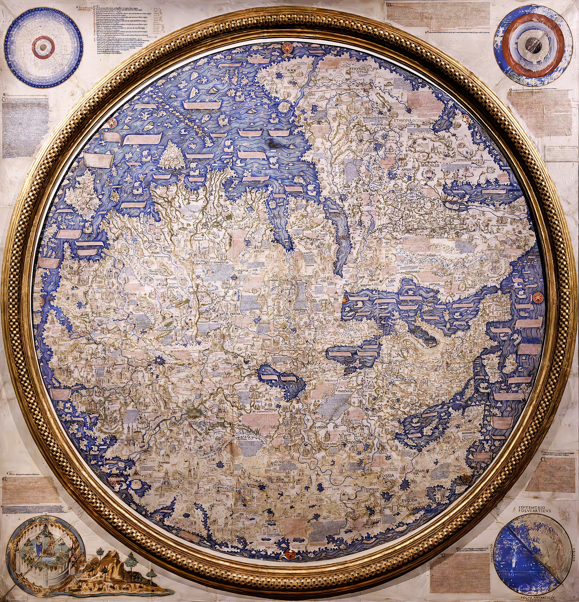
It is not the Fra Mauro World Map, a much larger (roughly two-meter) circular mappamundi of about 1450 made by the Camaldolese monk Fra Mauro, held at the Biblioteca Nazionale Marciana in Venice - a different object, by a named maker, at a different Italian library, already covered elsewhere in this archive. The two maps do share a documented source: both draw on Niccolo de' Conti's account as recorded by Poggio Bracciolini, which is exactly the kind of genuine overlap that makes the two easy to conflate.
It is not the 1424 Zuane Pizzigano chart, a Venetian portolan chart held at the James Ford Bell Library at the University of Minnesota, three decades earlier, unrelated in authorship, and notable for a completely different reason - it is the first known chart to show the phantom Atlantic islands of the Antillia group. It is not the Catalan Atlas of 1375, an earlier Majorcan-Catalan mappamundi sometimes cited alongside this map as an ancestor in the same hybrid portolan-and-mappamundi tradition, but separated from it by more than eighty years and a different cartographic school entirely.
It is also not connected, so far as any source consulted for this record shows, to Paolo dal Pozzo Toscanelli's 1474 letter and chart to the Portuguese court, later said to have been sent on to Christopher Columbus. That document is a wholly separate case: the original is lost, no map survives, and only a speculative nineteenth-century reconstruction exists of what it might have shown. A stray line in one low-quality secondary account of this map claims it, too, was 'sent to the Portuguese court in 1474 and then to Columbus' - a claim this record could not verify anywhere else and that looks very much like a conflation with the entirely separate Toscanelli episode. It is omitted here rather than repeated.
Chapter 10What is still argued
Scholarly disagreement about this map is real but narrower than the fringe literature's claims.
Scholarly disagreement about this map is real but narrower than the fringe literature's claims. The central published academic debate, carried most substantially by Gerda Brunnlechner's 2013 study in Peregrinations and a 2022 follow-up in Imago Mundi, is over how to characterize the map's place in the history of cartography: whether it is best read as a 'stepping stone' toward the fully modern, coordinate-based charts that followed within a few decades, or whether that framing imposes a tidy line of progress on a genuinely hybrid, ambiguous object that does not resolve cleanly into either the medieval or the modern camp. That is a debate about categories and narrative, not about where the map's information came from, and this record does not arbitrate it further than naming both positions and the scholar who has argued each.
The artist
Unidentified cartographic workshop, working under Genoese patronage, 1457
No maker's name appears anywhere on this sheet, and no source consulted for this record identifies one. What can be described is not a person but a working arrangement: a cartographer who laid out the coastlines, the coordinate grid and the rhumb-line network in a hand trained, on the evidence of the toponyms, somewhere in Castile rather than in Genoa itself, working for or alongside a Genoese patron whose arms, and the arms of the Spinola merchant family, appear on the finished object. A separate miniaturist's hand is visible in the heraldic banners, ships, sea creatures and gold-powder highlighting. This record treats that workshop, not an invented individual, as the maker.
Related works
| Work | Relation | Where it is |
|---|---|---|
| Fra Mauro's World Map Fra Mauro | Contemporary large Venetian mappamundi (c. 1450) drawing on the same Niccolo de' Conti account; a genuinely different object at a different library, frequently confused with this one Made by a named Camaldolese monk with a documented workshop, unlike this map's anonymous hand. | Biblioteca Nazionale Marciana, Venice (already a separate published record in this archive) |
| The Pizzigano chart Zuane Pizzigano | Earlier Venetian portolan chart (dated 22 August 1424) sometimes loosely grouped with this map in discussions of early Atlantic cartography Three decades earlier, unrelated authorship, and notable chiefly for the earliest known depiction of the phantom Antillia island group - it carries no East Asian content. | James Ford Bell Library, University of Minnesota, Minneapolis |
| The Catalan Atlas Attributed to the Majorcan cartographic school (Cresques Abraham workshop) | Earlier (1375) hybrid portolan-and-mappamundi world map, cited by historians as an ancestor of this map's synthesis of traditions Separated from this map by more than eighty years and a different regional school. | Bibliotheque nationale de France, Paris |
| Toscanelli's 1474 letter-map to the Portuguese court Paolo dal Pozzo Toscanelli | A wholly separate, non-surviving document occasionally and incorrectly conflated with this map in low-quality secondary accounts No source consulted for this record supports any link between the two objects. | Not extant; only a speculative 1898 reconstruction exists |
| The Kangnido map (Gangnido) Korean cartographic workshop, from a 1402 prototype | Cited by scholars, including Angelo Cattaneo, as a structural comparison illustrating mid-fifteenth-century global cartographic consciousness from the opposite direction Not a source for this map and not a version of it - a genuinely independent, contemporary East Asian world map included here only for comparison. | Ryukoku University Library, Kyoto (a 1479-1485 copy of the 1402 original, which does not survive) |
Open questions
- Who actually drew and lettered the map? The Castilian-orthography toponyms and the Genoese heraldry point in different directions, and no cartographer, scribe or miniaturist is named on the sheet or identified by any source consulted.
- Where was the map between its execution in 1457 and its first documented appearance in the Medici collections by the seventeenth century? No source consulted accounts for this gap of roughly a century and a half.
- Exactly when did the map pass from Uffizi display into the custody of the Biblioteca Palatina, and exactly when was it recatalogued from the old Palatina number to the current 'Portolano 1'? Neither transition date is given in the sources consulted.
- Which of the differing published dimensions (39.5 x 79.5 cm; 75 x 37 cm; 82 x 41 cm) actually describes the original parchment, and which describe facsimile-edition sheets? Not reconciled in the sources consulted.
- Has the original undergone any conservation treatment since Stevenson's 1912 description of significant pigment loss and rubbing damage? No record of one was found.
- Is there any actual textual basis for the claim, found in one low-quality secondary source, that the map was sent to the Portuguese court in 1474 and later to Columbus - or is this a conflation with the separate, non-surviving Toscanelli letter-map episode of the same year?
Questions about this object
What is The Genoese World Map of 1457?
The Genoese World Map of 1457 is a map, dated 1457. Medium: Ink and tempera pigment in six colors, with gold-powder highlighting, on a single parchment sheet.
Who made The Genoese World Map of 1457, and is the attribution settled?
The attribution to Anonymous Genoese cartographic workshop is recorded here as unknown. Nothing on the sheet names a maker. The coat of arms of the Republic of Genoa and of the Spinola family identify a Genoese context of patronage or ownership, which is why the map carries the name it does, but that is a mark of sponsorship, not a signature. The Biblioteca Nazionale Centrale's own catalogue entry and the 2008 facsimile commentary by Angelo Cattaneo describe the toponyms as written in Castilian orthography, and propose that the drafting hand, or at least the scribe who lettered the place names, trained or worked in Castile rather than in Genoa itself. The finished object required more than one set of hands: a cartographer for the coastlines, rhumb network and coordinate grid, and a separate miniaturist for the heraldic banners, ships, sea creatures and gold-powder highlighting.
Where is The Genoese World Map of 1457 now?
Biblioteca Nazionale Centrale di Firenze (National Central Library of Florence), Florence, Italy. Inventory number Portolano 1, per the library's own 'Tesori svelati' historical-catalogue entry and the Encyclopaedia of Portuguese Expansion. Edward Luther Stevenson's 1912 study instead records the shelfmark then in use, 'Sezione Palatina No. 1, Planisfero Mediceo' - the map's older number under the Grand-Ducal Palatine Library before that library's later reorganisation within the Biblioteca Nazionale Centrale.. Last confirmed 6 September 2026. Continuous documented custody within Florentine state and princely collections since at least the seventeenth century; owned today by the Italian state and held by the Biblioteca Nazionale Centrale di Firenze.
What is still unknown about The Genoese World Map of 1457?
Who actually drew and lettered the map? The Castilian-orthography toponyms and the Genoese heraldry point in different directions, and no cartographer, scribe or miniaturist is named on the sheet or identified by any source consulted.
Sources
- 1Wikimedia Commons, file description and Library of Congress catalog note for 'File:Genoese world map 1457. LOC 97690053.jpg' (LOC item 97690053), quoting: 'Title from Stevenson's text... In lower right corner: E.O. Cockayne, Boston... LC copy mounted on cloth and laminated.' commons.wikimedia.org/wiki/...
- 2Wikimedia Commons API (), license verification for the same file: LicenseShortName 'Public domain', justified on the file page as 'a faithful photographic reproduction of a two-dimensional, public domain work of art.' commons.wikimedia.org/w/...
- 3Edward Luther Stevenson (ed.), incorporating the studies of Theobald Fischer, Genoese World Map, 1457: Facsimile and Critical Text (New York: De Vinne Press, issued jointly by the American Geographical Society and the Hispanic Society of America, 1912) - full text via Internet Archive, for the photographic reproduction process (Istituto Geografico Militare, negatives of 1905), the map's 1912-era shelfmark ('Sezione Palatina No. 1, Planisfero Mediceo'), its condition, mounting on four boards, and sourcing notes on Marco Polo, Niccolo de' Conti and Arabic geography. archive.org/details/...
- 4Encyclopaedia of Portuguese Expansion (CHAM, Universidade Nova de Lisboa), 'Genoese World Map drawn in 1457' - for the current shelfmark Portolano 1, dimensions, inscription translation, Medici/Uffizi provenance, Castilian toponym orthography, Poggio Bracciolini/Niccolo de' Conti and Isidore of Seville/al-Idrisi sourcing, and the Kangnido comparison. eve.fcsh.unl.pt/en/...
- 5Biblioteca Nazionale Centrale di Firenze / Istituto dell'Enciclopedia Italiana (Treccani), 'Mappa Mundi 1457,' Tesori Svelati historical-catalogue entry - for dimensions, six-color palette with manual retouching and gold-powder highlighting, toponym and cartouche counts, littera textualis script, Castilian-origin cartographer attribution, Angelo Cattaneo's 2008 facsimile commentary, and iconographic inventory (ships, sirens, city views, heraldic banners, animals). treccani.it/istituto/...
- 6Cartography Unchained, '1457 World Map; Genoese, Yes! Draughtsmanship before History' - for the Ptolemaic-content analysis (c. 87 percent derived from Ptolemy's Geographia via Jacopo Angelo di Scarparia's 1406 Latin translation), the Genoa-centered longitudinal alignment, ancient sources (Periplus of the Erythraean Sea, Herodotus, Strabo), and comparison with the Fra Mauro map. cartographyunchained.com/cg1457
- 7Facsimile Finder, 'Genoese World Map of 1457' - for the 2008 Istituto della Enciclopedia Italiana (Treccani) facsimile edition details: limited run of 750 copies, commentary by Juan Gil, Gino Benzoni and Angelo Cattaneo, and an alternate published dimension for the original (75 x 37 cm). facsimilefinder.com/facsimiles/...
- 8Carleton College, 'Genoese World Map,' Mapping the World exhibit (HIST 231) - for David Woodward's 'transitory mappamundi' characterization, the proposed mandorla reading of the oval outline, the absence of Garden-of-Eden/Jerusalem-centered imagery, and details of a modern Treccani facsimile held in Carleton's own collection. hist231.hist.sites.carleton.edu/items/...
- 9Its uncorroborated claim that the map was 'sent to the Portuguese court in 1474 and then to Columbus' is explicitly NOT used in this record; see source 12 and the narrative section addressing likely confusion with the Toscanelli episode. en.wikipedia.org/wiki/...
- 10Used for Conti's travel dates and route, his 1444 dictation to Poggio Bracciolini, and the documented statement that his account shaped both the Fra Mauro map and this map. en.wikipedia.org/wiki/...
- 11Wikipedia, 'Zuane Pizzigano.' source, used for the exact date (22 August 1424) and current location (James Ford Bell Library, University of Minnesota) of the Pizzigano chart, for the purpose of distinguishing it from this map. en.wikipedia.org/wiki/...
- 12Wikipedia, 'Paolo dal Pozzo Toscanelli' (page title 'Paul Toscanelli'). en.wikipedia.org/wiki/...
- 13Wikipedia, 'Biblioteca Nazionale Centrale di Firenze' / 'National Central Library (Florence).' source, used for the library's 1714 founding as the Magliabechiana, its 1861 merger with the Biblioteca Palatina, and its renaming as the Biblioteca Nazionale Centrale di Firenze by 1885. en.wikipedia.org/wiki/...
- 14Robert Finlay, 'How Not to (Re)Write World History: Gavin Menzies and the Chinese Discovery of America,' Journal of World History 15, no. 2 (2004), as republished by History Cooperative - for the peer-reviewed rebuttal of Gavin Menzies's 1421 thesis: the absence of any 'missing years' gap in the documented Ming naval chronology, Menzies's mishandling of Niccolo de' Conti's itinerary, and Menzies's demonstrated misuse of the Piri Reis map as a methodological parallel for how he treats cartographic evidence generally. historycooperative.org/not-rewrite-world-history-gavin-me...
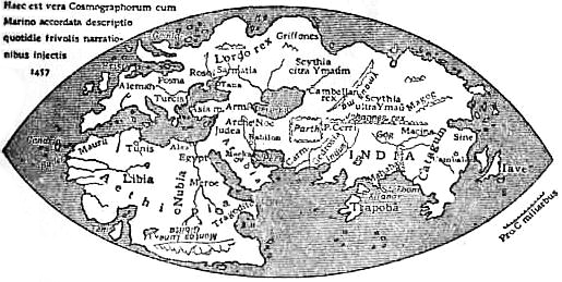
- 15Wikimedia Commons, 'File:EB1911 - Map - Fig. 24 - Genoese Map (1457).jpg' - source and license verification for the 1911 Encyclopaedia Britannica line-diagram reproduction used as a context image in this record. commons.wikimedia.org/wiki/...


.jpg)
Last verified · Published
Change log
6 September 2026 - Record created at the house standard: researched narrative, technical evidence, maker dossier, graded provenance chain, prices with hammer and premium separated, related works, open questions and sources.