Fra Mauro's World Map (Mappamondo di Fra Mauro)
Fra Mauro · c. 1450
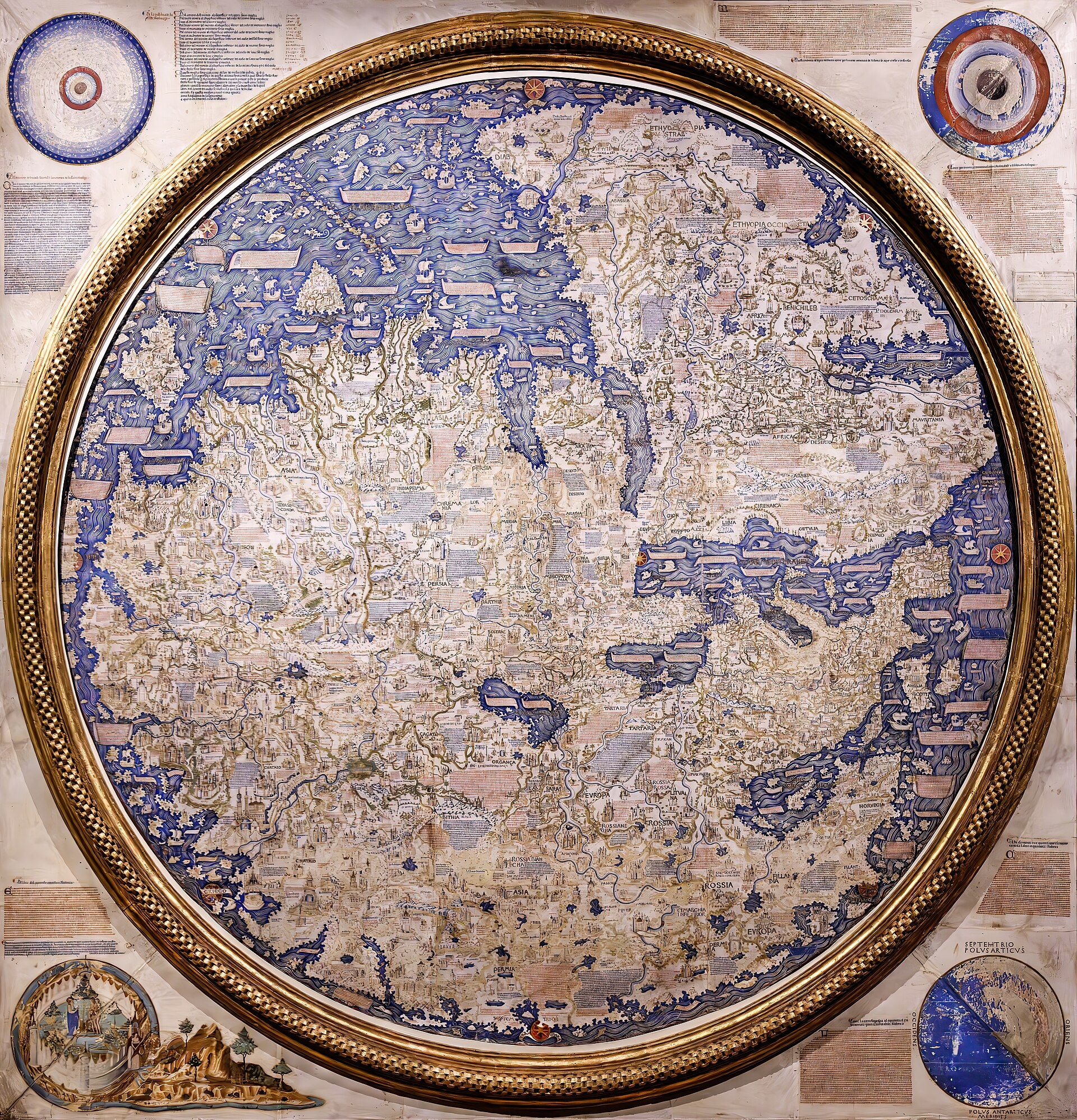
The complete map as it survives today at the Biblioteca Nazionale Marciana, Venice. Photograph by Didier Descouens, 2023. A flat photographic reproduction of a public-domain fifteenth-century object; Fra Mauro died 1464, so Section 68 UrhG applies and the Commons file is independently tagged Public domain.
| Artist | Fra Mauro |
|---|---|
| Date | c. 1450 |
| Medium | Ink, tempera and gold leaf on vellum (parchment), the sheets mounted on a wood-panel support, set within a wooden frame |
| Dimensions | Circular map approximately 196 cm in diameter, within a square wooden frame of approximately 223 x 223 cm; general sources commonly round this to just over two meters square |
| Where it is now | Biblioteca Nazionale Marciana, Venicelast confirmed |
| Inventory number | Not confidently established from the sources consulted; omitted rather than guessed |
| Attribution | AcceptedAuthorship is not disputed. Full note |
| Object type | Map |
| Period | Italian (Venetian), fifteenth century |
| Cases | Seized, looted or confiscated |
| Inscriptions | Approximately 2,991 descriptive legends in Venetian vernacular per the Museo Galileo digital edition; Piero Falchetta's critical edition separately transcribes 2,419 discrete place-names within this corpus. Several legends are picked out in gold leaf. |
| Owners on record | 6 links6 documented |
| Sources | 21 cited |
About this record Last verified · 21 sources cited · Change log
On this page 9 sections
ContentsClose
A large circular mappamundi made around 1450 in the Camaldolese monastery of San Michele in Isola, Venice, by the lay brother and self-taught cosmographer Fra Mauro, working with the sailor-cartographer Andrea Bianco and a Venetian workshop of writers and artists. Oriented with south at the top and carrying close to three thousand descriptive legends, it broke decisively with the schematic, Jerusalem-centered medieval mappaemundi that came before it, offering instead an empirically-argued geography whose rendering of Africa's shape anticipated, without yet proving, the continent's circumnavigability.
In 1457 the court of King Afonso V of Portugal commissioned a copy of the map from the same monastery, paying 28 ducats for work completed and dispatched to Lisbon by 24 April 1459. That Portuguese copy was housed in the royal palace at Sao Jorge Castle and disappeared after 1494; no part of it is known to survive. The commission itself is not in dispute among historians - it is a documented archival fact - only the object is lost. The map's African coastal detail is itself the subject of genuine, ongoing scholarly interest: the West African coast reflects real, near-contemporary exploration data reaching Venice through Italian merchants and travelers, while the far more speculative claim of a navigable route around Africa's south rests on a secondhand Indian Ocean account combined with a classical text, not on any actual Portuguese sighting of the Cape.
Only one Fra Mauro world map survives: the one described in this record, generally identified with the copy the Signoria of Venice commissioned and which Andrea Bianco completed after Fra Mauro's death. It remained at San Michele in Isola until the Napoleonic suppression of the monastery around 1810-11, passed into state custody, spent a period on display in the Doge's Palace, and has been held by the Biblioteca Nazionale Marciana since 1924, where it remains on public view today.
Provenance
Each link is graded. Documented: a cited source supports it. Disputed: the identification is argued but not established. Unknown: no owner for that span, and the gap is not smoothed into a narrative. The grades in the glossary.
- c. 1448-1450 -Fra Mauro and workshop (with Andrea Bianco)documented
Made at the Camaldolese monastery of San Michele in Isola, Venice; Fra Mauro left it unfinished at his death and Andrea Bianco completed it. This much is documented. What is NOT settled in the sources consulted is whether the surviving Marciana map is itself the copy the Signoria of Venice commissioned, or an earlier prototype from which both the Signoria's and the lost Portuguese copies were made; this record treats the Signoria identification as the working assumption most sources use, not as a settled fact (see open questions).123
- - 1464Fra Mauro, then completed by Andrea Biancodocumented
Fra Mauro died, by the most widely cited modern reckoning in 1464, while still at work on this copy; Andrea Bianco completed it after his death. A minority of sources place Fra Mauro's death earlier, around 1459-60.21
- 1464 - c. 1810Monastery of San Michele in Isola, Venicedocumented
The map remained at the monastery for roughly three and a half centuries, alongside Fra Mauro's other papers, which were themselves sealed in a chest at San Giovanni Battista on the Giudecca after his death and later returned to San Michele.138
- c. 1810 - c. 1811Kingdom of Italy (Napoleonic administration), then the Biblioteca Nazionale Marcianadocumented
Napoleon's suppression of religious orders in the former Venetian territories ended the Camaldolese community's tenure of San Michele in Isola; the map passed into state custody and was moved to the Biblioteca Nazionale Marciana.1
- c. 1811 - 1924Displayed in the Doge's Palace (rooms associated with the Venetian Great Council)documented
The map was shown in the Doge's Palace for an extended period before its return to the Marciana; exact dates within this century-long interval are not documented in the sources consulted.1
- 1924 - presentBiblioteca Nazionale Marciana, Venicedocumented
The map returned permanently to the Biblioteca Marciana in 1924 and remains there, on public display in the final room of the Sale Monumenti, reached as part of the shared Piazza San Marco museum circuit that also takes in the Museo Correr.19
Technical evidence
| Attribution note | Authorship is not disputed. Fra Mauro is documented as a lay brother of the Camaldolese monastery of San Michele in Isola, Venice, from 1409, and contemporary sources style him cosmographus incomparabilis for this and other cartographic work. The map was produced by a workshop under his direction, with the sailor-cartographer Andrea Bianco as his principal named collaborator, who completed the Venetian Signoria's copy after Fra Mauro's death. |
|---|---|
| Support | Sheets of vellum (parchment) mounted on a wood-panel support, set within a wooden frame.19 |
| Dimensions | Circular map approximately 196 cm in diameter, within a square wooden frame of approximately 223 x 223 cm; general sources commonly round this to just over two meters square.91 |
| Orientation | South-up, unusual for European cartography of the period. Fra Mauro justifies the choice by reference to contemporary compass convention and to Arab mapping practice.1 |
| Legends and inscriptions | Approximately 2,991 descriptive legends in Venetian vernacular per the Museo Galileo digital edition. Piero Falchetta's critical edition separately transcribes 2,419 discrete place-names within this corpus. Several legends are picked out in gold leaf.711 |
| Corner cosmological diagrams | Four roundels set outside the main circle: a Ptolemaic cosmological diagram, a diagram of the four classical elements, an image of the Garden of Eden painted by the illuminator Leonardo Bellini (nephew of Jacopo Bellini), and a globe showing the poles, equator and tropics.1 |
| Earth's circumference estimate | An inscription gives the circumference of the earth as 22,500 to 24,000 miglia (miles), with Fra Mauro explicitly flagging the figure as unverified since, in his own words, it has not been tested.1 |
| Absence of scale and rhumb lines | Unlike a portolan sea-chart, the map carries no distance scale and no rhumb-line network; only cardinal-direction labels and the corner cosmological notes provide orientation.9 |
Images
The record in full
Chapter 1What it is
The map is a circular planisphere approximately 196 cm across, painted in ink, tempera and gold leaf on sheets of vellum mounted on a wood-panel support, set within a gilded wooden frame of roughly...
The map is a circular planisphere approximately 196 cm across, painted in ink, tempera and gold leaf on sheets of vellum mounted on a wood-panel support, set within a gilded wooden frame of roughly 223 by 223 cm. It is oriented with south at the top, an arrangement Fra Mauro defends explicitly in the map's own text by reference to the south-pointing compass conventions of his day and to the precedent of Arab cartography.
Unlike a portolan sea-chart, it carries no distance scale and no network of rhumb lines; orientation is given only by cardinal-direction labels and by four cosmological roundels set outside the main circle, at the corners of the frame: a Ptolemaic cosmological diagram, a diagram of the four classical elements, an image of the Garden of Eden painted by the illuminator Leonardo Bellini (nephew of the painter Jacopo Bellini), and a globe showing the poles, equator and tropics. Close to three thousand descriptive legends are set into the body of the map itself, several of them picked out in gold leaf.
Chapter 2How it was made
Fra Mauro was not a university-trained scholar but a lay brother, recorded in the registers of San Michele in Isola from 1409, who had reportedly traveled earlier in life as a merchant and a soldier...
Fra Mauro was not a university-trained scholar but a lay brother, recorded in the registers of San Michele in Isola from 1409, who had reportedly traveled earlier in life as a merchant and a soldier with direct experience of the eastern Mediterranean and Middle East. His early professional work for the monastery was practical rather than theoretical: topographic surveys of its landholdings at San Michele di Leme in Istria, and hydrological engineering that included work on diverting the course of the river Brenta.
From about 1448-49 he turned his attention to world maps, and his contemporaries came to style him cosmographus incomparabilis, the incomparable cosmographer. The map itself was not a solitary achievement: it was produced by a workshop of cartographers, copyists and artists working under his direction, using costly pigments and gold leaf, over a production process that is estimated to have taken several years and to have cost roughly as much as a copyist's annual salary. Andrea Bianco, a sailor-cartographer who had already signed his own small nautical atlas in Venice in 1436 and a chart in London in 1448, joined this workshop as Fra Mauro's principal named collaborator.
Chapter 3The break with the T-O tradition
Medieval European mappaemundi conventionally followed the schematic T-O form: a disc centered on Jerusalem, oriented with east at the top toward the Earthly Paradise, organized to teach biblical...
Medieval European mappaemundi conventionally followed the schematic T-O form: a disc centered on Jerusalem, oriented with east at the top toward the Earthly Paradise, organized to teach biblical geography rather than to record observed fact. Fra Mauro's map abandons this scheme at several explicit points.
He removes the Earthly Paradise from its conventional place inside the inhabited world altogether, relegating it to one of the four external corner roundels rather than locating it as a real place at the eastern edge of the earth. He also displaces Jerusalem from the map's geometric center, and defends the choice in his own words: though Jerusalem might be central in latitude, he argues, in longitude the greater population of Europe justifies shifting the effective center to the west. This is a rare surviving case of a fifteenth-century cartographer stating outright that observed human geography, not scriptural convention, should govern a map's construction. The historian Jerry Brotton has described the map, on these grounds, as marking the point at which the medieval mappaemundi built on biblical schema began to give way to something else - an empirically argued geography rather than a theological diagram.
Chapter 4Venice as an information exchange
The map's Asian geography rests heavily on two named written sources: the travel account of Marco Polo, and that of Niccolo de' Conti, an Italian merchant who traveled through Asia between 1419 and...
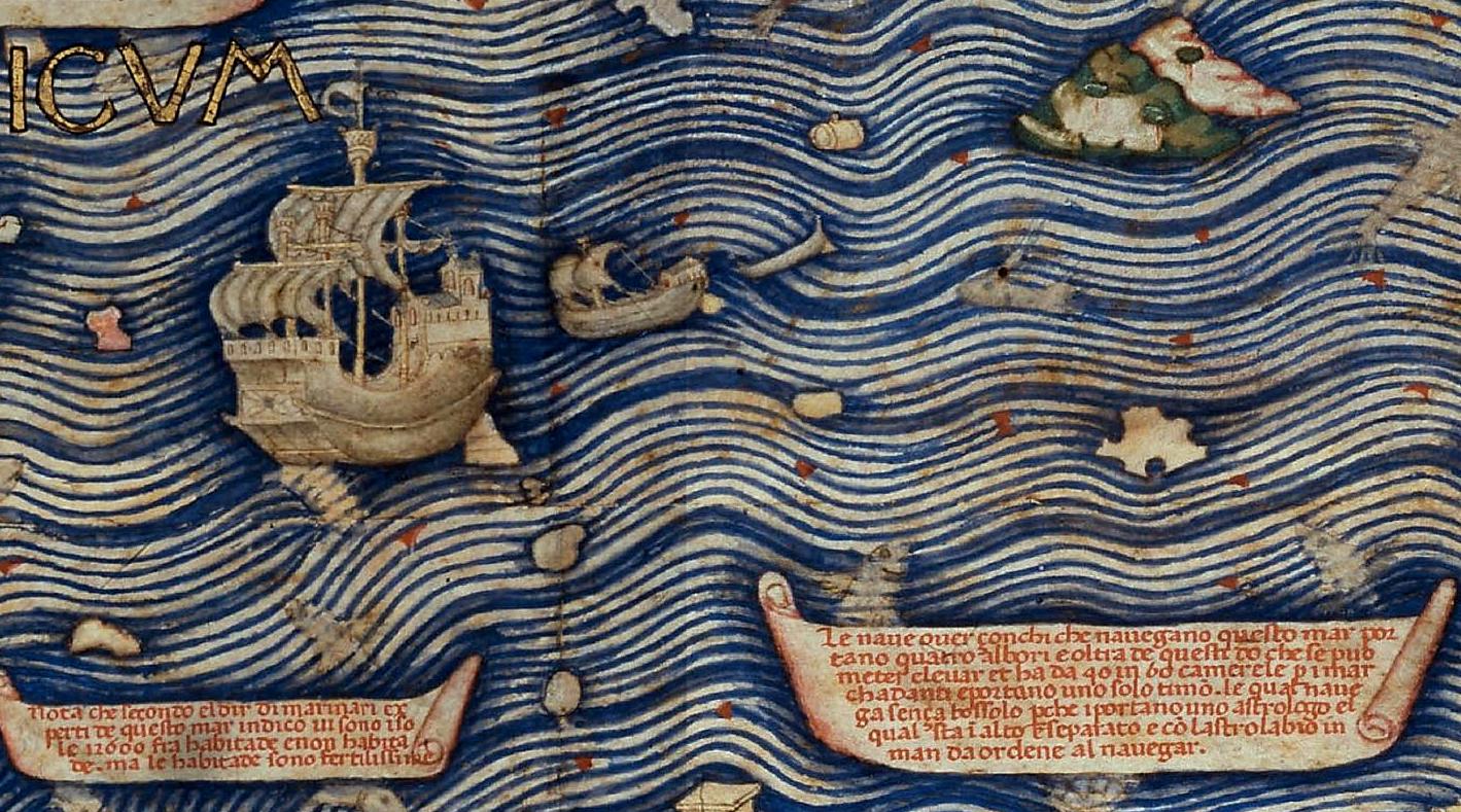
The map's Asian geography rests heavily on two named written sources: the travel account of Marco Polo, and that of Niccolo de' Conti, an Italian merchant who traveled through Asia between 1419 and 1439 and from whose account Fra Mauro appears to have drawn place names and passages close to verbatim, including material behind the map's inscription describing a large Indian Ocean vessel voyage of around 1420.
Beyond these two texts, Fra Mauro's own working method, as reconstructed by later scholarship, combined library sources with contemporary oral testimony gathered in Venice itself - a city that functioned as a clearing house for travelers, merchants and sailors returning from every part of the known world, whose accounts Fra Mauro appears to have sought out and cross-checked directly. Southeastern African detail is thought to derive substantially from an Ethiopian embassy that visited Rome in this period, and the map's south-up convention itself follows Arab cartographic precedent, most notably that of the twelfth-century geographer al-Idrisi.
Chapter 5The Portuguese commission, and its loss
In 1457 the court of King Afonso V of Portugal commissioned the monastery of San Michele in Isola to produce a copy of the map and its accompanying texts.
In 1457 the court of King Afonso V of Portugal commissioned the monastery of San Michele in Isola to produce a copy of the map and its accompanying texts. The surviving account records describe the task specifically as making a copy of a pre-existing world map, rather than as an original new composition - a detail worth noting precisely, since it raises an unresolved question about the relationship between this commission, the Signoria of Venice's own commissioned copy, and the map that survives today.
Between 1457 and 1459 the Portuguese court paid the monastery 28 ducats for the work. Fra Mauro spent roughly two years on it together with Andrea Bianco and unnamed Venetian writers and artists. The finished copy was completed and dispatched to Lisbon by 24 April 1459, entrusted to a messer Stefano Trevisan, possibly a Venetian patrician, whose exact role is not further documented in the sources consulted. It was housed in the royal palace at Sao Jorge Castle in Lisbon at least until 1494, after which it disappears from the record; no part of it is known to survive today.
This commission and payment are not, in themselves, disputed by historians: they rest on the monastery's own archival account records, referenced consistently in the Biblioteca Marciana's and the Museo Galileo's own published scholarship on the map. What is lost is the physical object, not the historical record of its having been made and paid for.
Separately, the Signoria of Venice commissioned its own copy of the map. Fra Mauro died, by the most widely cited modern reckoning in 1464 (though a minority of sources place his death as early as 1459-60), while still at work on this Venetian copy, and Andrea Bianco completed it after his death. This Venetian copy is generally identified with the map that survives today in the Biblioteca Marciana - though, as above, the precise relationship between an original design, the lost Portuguese copy, and this Venetian copy is not fully reconciled across the sources consulted for this record.
Chapter 6The scholarly debate over the African data
Two distinct claims about Africa need to be kept separate, because the evidence behind them is of a different order.The map's depiction of the West African coast, down to roughly the areas reached by...
Two distinct claims about Africa need to be kept separate, because the evidence behind them is of a different order.
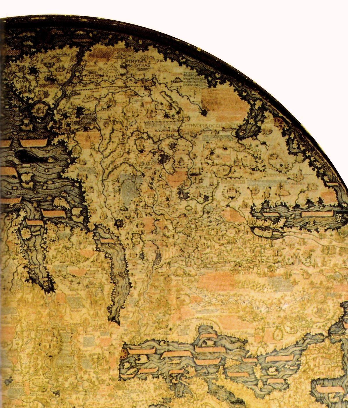
The map's depiction of the West African coast, down to roughly the areas reached by Portuguese-sponsored voyages through the 1450s, reflects real, near-contemporary exploration data. Portuguese captains active in these years, including Nuno Tristao in the 1440s, pushed exploration steadily down the coast, and the Venetian navigator Alvise Cadamosto, sailing in Portuguese service, is illustrated on the map beyond Cape Blanco following his voyages of 1455-56; Cadamosto's own account of these voyages, the Navigazioni, was later printed in 1507, but the underlying geographic information plainly reached Venice earlier, carried by the same merchant and traveler networks that fed the rest of the map. This part of the map's African detail is not seriously disputed as a record of genuine information in circulation, rather than of classical or literary compilation alone.
The far more speculative claim concerns the map's suggestion that Africa could be sailed around altogether. An inscription near the map's Cape of Diab, at the southern extremity of Africa, describes a large multi-masted vessel that reportedly sailed some 2,000 miles to the southwest over 40 days around 1420 before turning back, taking 70 days to return. Fra Mauro explicitly combines this secondhand account with the classical description, transmitted through Strabo, of Eudoxus of Cyzicus's supposed circumnavigation of Africa in antiquity, and concludes from the pairing that the Indian Ocean must be open rather than landlocked. This is not Portuguese exploration data: Bartolomeu Dias did not round the Cape of Good Hope until 1488, nearly three decades after Fra Mauro's death, so no Portuguese voyage could have supplied this claim. It is instead an inference built from a vague contemporary report and an ancient text, and mainstream historians do not treat it as evidence that anyone had actually sailed around Africa's southern tip by 1459. Non-scholarly claims occasionally cite this passage as proof of a pre-Columbian Chinese or Indian circumnavigation of Africa; that reading is not supported in the scholarly literature consulted for this record and should be treated as speculative overreach rather than an accepted finding.
The two standard modern authorities on the map do not, in fact, sit on opposite sides of a real-data-versus-classical-compilation divide. Piero Falchetta, long the curator of the Marciana's cartographic collections, produced the map's standard critical edition and catalogue in 2006, identifying and transcribing its source material place-name by place-name. Angelo Cattaneo's 2011 monograph situates the map within Venetian intellectual life of the period, showing it as a genuine synthesis: the classical and scholastic auctores veteres (Pliny, Solinus, Ptolemy) and later authorities (Albert the Great, Thomas Aquinas, Marco Polo, Niccolo de' Conti) combined with the composite contemporary networks of scholasticism, humanism, monastic culture, and mercantile and maritime practice. Both authorities converge on the same reading, differing in method rather than verdict: the map is neither pure inherited text nor pure fresh data, and the substantive scholarly work lies in tracing, inscription by inscription, which category each piece of information belongs to.
Chapter 7Survival: monastery, suppression and return
The map remained at San Michele in Isola for roughly three and a half centuries after its creation.
The map remained at San Michele in Isola for roughly three and a half centuries after its creation. Napoleon's suppression of religious orders in the former Venetian territories, decreed around 1810, ended the Camaldolese community's tenure of the island, and the map passed into state custody, moving to the Biblioteca Nazionale Marciana around 1810-11. It was displayed for a period afterward in the Doge's Palace, in the rooms associated with the Venetian Great Council, before returning permanently to the Biblioteca Marciana in 1924, where it has remained since.
Fra Mauro's own working papers and any other maps in his hand were sealed, after his death, in a chest kept at the Camaldolese house of San Giovanni Battista on the Giudecca, and returned to San Michele in Isola by 1464. By the eighteenth century this material had dispersed entirely; only the finished world map itself survived, in institutional memory and in fact.
Chapter 8Reproduction and modern scholarship
The first full scholarly study of the map, Giacinto Placido Zurla's Il mappamondo di Fra Mauro, appeared in 1806.
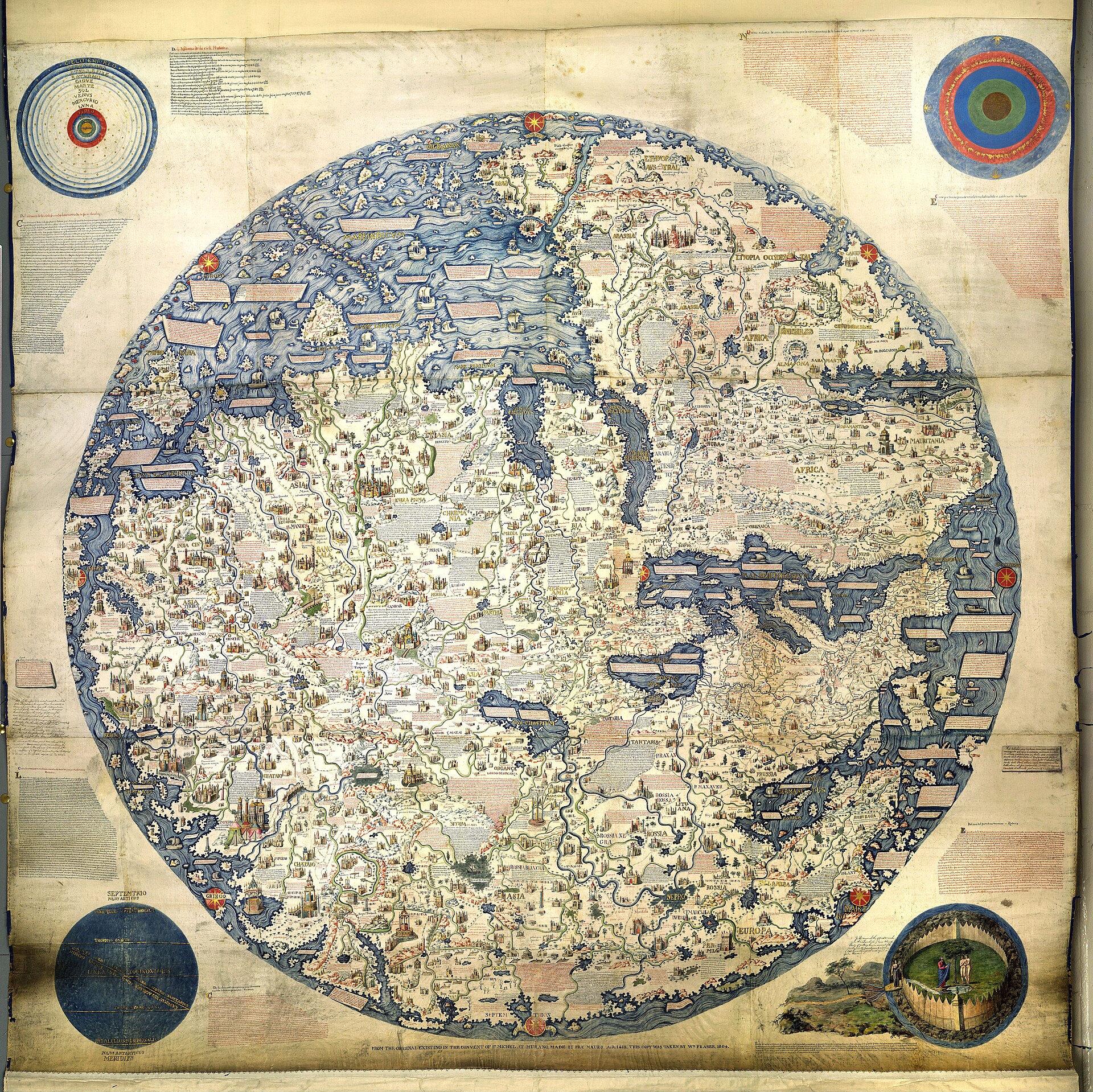
The first full scholarly study of the map, Giacinto Placido Zurla's Il mappamondo di Fra Mauro, appeared in 1806. In the same period the British cartographer William Fraser produced an exact vellum copy of the map, differing only in minor details from the Venetian original; that 1806 copy is now held by the British Library in London, and is a documented facsimile rather than an independent version of the composition.
The next full critical treatment did not appear until two centuries later: Piero Falchetta's critical edition of 2006, issued in the Terrarum Orbis series, paired a volume of scholarly commentary with a CD-ROM carrying a high-resolution image and cross-referencing software, and Falchetta followed it with a shorter history of the map in 2013. Angelo Cattaneo's intellectual-historical monograph appeared in 2011. In March 2022 the Museo Galileo, in partnership with the Biblioteca Nazionale Marciana and Nanyang Technological University in Singapore, launched an open-access digital edition of the map, curated by Filippo Camerota and Angelo Cattaneo and presented in Italian, English and Chinese, allowing detailed multimedia exploration of its roughly 2,991 legends.
Chapter 9What is happening now
The map remains on public display at the Biblioteca Nazionale Marciana, in the final room of its Sale Monumenti, reached as part of the shared Piazza San Marco museum circuit that also takes in the...
The map remains on public display at the Biblioteca Nazionale Marciana, in the final room of its Sale Monumenti, reached as part of the shared Piazza San Marco museum circuit that also takes in the Museo Correr. The Museo Galileo's open-access digital edition remains live.
No new conservation campaign, sale, litigation or export event was found in the sources consulted for this record. Since its return to the Marciana in 1924, the map has been institutionally stable, in continuous Italian state custody, its history over the past century one of scholarship and display rather than dispute - a plain finding rather than a gap in the research.
The artist
Fra Mauro (lay brother of the Camaldolese monastery of San Michele in Isola; no secular birth name is securely documented in the sources consulted)
Fra Mauro was not a university-trained natural philosopher but a lay brother of a Venetian monastery, whose authority in cosmography rested entirely on practical experience and self-directed study rather than on scholastic credentials. That an unlettered monk could be granted, within his own lifetime, the title cosmographus incomparabilis - the incomparable cosmographer - by a culture that otherwise deferred to university learning is itself part of what this record is about.
Related works
| Work | Relation | Where it is |
|---|---|---|
| Nautical atlas of 1436 Andrea Bianco | By Fra Mauro's principal named collaborator on this map; a small signed atlas of seven nautical charts plus a round world map and a Ptolemaic planisphere Bianco signed this atlas in Venice in 1436 and a further nautical chart in London in 1448, more than a decade before joining Fra Mauro's workshop; it shows the navigational and cartographic training he brought to the commission. | Biblioteca Nazionale Marciana, Venice |
| Genoese World Map (1457) Unknown Genoese hand | A separate, contemporary Italian mappamundi, NOT a version of this object Made in the same years as Fra Mauro's map but in an elliptical rather than circular format, and relying more heavily on Niccolo de' Conti's account and on portolan-chart precision than on the same broad Venetian informant network. Often invoked as comparanda; should never be captioned as a version of the Marciana map. | Held in Florence, per the general cartographic-historical literature consulted (not independently re-verified against a fetched primary source in this research pass) |
| Portuguese copy of Fra Mauro's map (lost) Fra Mauro, with Andrea Bianco and a Venetian workshop | The 1457-59 commission for King Afonso V of Portugal; a lost sibling object, not a surviving version Included here specifically to make its non-survival explicit, since it is easily confused with the map described in this record. | Unlocated; last recorded at the royal palace of Sao Jorge Castle, Lisbon, until 1494 |
| William Fraser's copy of the map (1806) William Fraser, after Fra Mauro | A documented nineteenth-century facsimile copy of the Marciana map, made during Placido Zurla's study of the original A copy, not an independent composition, and not the object described in this record; differs from the Venetian original only in minor details. | British Library, London |
| Latin copy of Fra Mauro's map (lost) Workshop tradition of Fra Mauro, commissioned a generation later | A further copy commissioned by Lorenzo de' Medici around 1480 Evidence that the map's design retained prestige well beyond Fra Mauro's own lifetime; this copy has not survived and is not itself an object described in this record. | Unlocated |
Open questions
- Is the map that survives today in the Biblioteca Marciana the Signoria of Venice's own commissioned copy (finished by Andrea Bianco after Fra Mauro's death), or an earlier prototype from which both the Signoria and Portuguese copies were made? The sources consulted for this record are not fully consistent on this point.
- What became of the Afonso V copy after it disappears from the record at Sao Jorge Castle following 1494? No later trace was found in the sources consulted.
- Who was messer Stefano Trevisan, the individual entrusted with carrying the 1459 copy to Lisbon, and what was his relationship to the Venetian or Portuguese courts? Not established beyond the possibility that he was a Venetian patrician.
- Does the Cape of Diab circumnavigation inscription preserve a genuine, if garbled, memory of an actual Indian Ocean voyage, or is it substantially a construction built from a vague contemporary rumor projected onto the classical account of Eudoxus of Cyzicus? This remains a live and unresolved question in the literature consulted.
- What is the precise, reconciled count of the map's legends and inscriptions? Sources consulted give figures of 2,419 (Falchetta's transcribed place-names), 2,991 (the Museo Galileo digital edition's legend count), and 'more than 3,000' (looser secondary accounts), and these have not been reconciled here.
- Where exactly was the map displayed, and under what conditions, during the century between its removal from San Michele in Isola around 1810-11 and its return to the Biblioteca Marciana in 1924? Only the two endpoints of this period are well documented in the sources consulted.
- Does any documentary trace of the lost Afonso V copy survive indirectly, for instance through later Portuguese cartographic works that might have consulted it before its disappearance? This was not examined in the sources consulted for this record.
Questions about this object
What is Fra Mauro's World Map (Mappamondo di Fra Mauro)?
Fra Mauro's World Map (Mappamondo di Fra Mauro) is a map, dated c. 1450. Medium: Ink, tempera and gold leaf on vellum (parchment), the sheets mounted on a wood-panel support, set within a wooden frame.
Who made Fra Mauro's World Map (Mappamondo di Fra Mauro), and is the attribution settled?
The attribution to Fra Mauro is recorded here as accepted. Authorship is not disputed. Fra Mauro is documented as a lay brother of the Camaldolese monastery of San Michele in Isola, Venice, from 1409, and contemporary sources style him cosmographus incomparabilis for this and other cartographic work. The map was produced by a workshop under his direction, with the sailor-cartographer Andrea Bianco as his principal named collaborator, who completed the Venetian Signoria's copy after Fra Mauro's death.
Where is Fra Mauro's World Map (Mappamondo di Fra Mauro) now?
Biblioteca Nazionale Marciana, Venice. Inventory number Not confidently established from the sources consulted; omitted rather than guessed. Last confirmed 15 August 2026. Transferred from the monastery of San Michele in Isola into state custody around 1810-11 following the Napoleonic suppression of religious orders; displayed for a period in the Doge's Palace before returning permanently to the Biblioteca Marciana in 1924, where it is on public view in the final room of the Sale Monumenti.
What is still unknown about Fra Mauro's World Map (Mappamondo di Fra Mauro)?
Is the map that survives today in the Biblioteca Marciana the Signoria of Venice's own commissioned copy (finished by Andrea Bianco after Fra Mauro's death), or an earlier prototype from which both the Signoria and Portuguese copies were made? The sources consulted for this record are not fully consistent on this point.
Sources
- 1Wikipedia, 'Fra Mauro map', consolidating physical description, sources, the T-O tradition break, the Cape of Diab inscription, and the survival/display history. en.wikipedia.org/wiki/...
- 2Wikipedia, 'Fra Mauro', for the biography, the 1457-59 and c.1480 commissions, and the death date. en.wikipedia.org/wiki/...
- 3Museo Galileo / Biblioteca Nazionale Marciana, 'Fra Mauro, Cosmographer' (Fra Mauro digital exhibition). mostre.museogalileo.it/framauro/...
- 4Museo Galileo / Biblioteca Nazionale Marciana, 'The Copy of the Map for the King of Portugal' (Fra Mauro digital exhibition). mostre.museogalileo.it/framauro/...
- 5Museo Galileo / Biblioteca Nazionale Marciana, 'Portuguese Expansion in Africa and into the Indian Ocean' (Fra Mauro digital exhibition). mostre.museogalileo.it/framauro/...
- 6Museo Galileo / Biblioteca Nazionale Marciana, 'Andrea Bianco' (Fra Mauro digital exhibition). mostre.museogalileo.it/framauro/...
- 7Museo Galileo news archive, 'The world map of Fra Mauro', on the March 2022 launch of the open-access digital edition with the Biblioteca Nazionale Marciana and Nanyang Technological University. www2.museogalileo.it/en/...
- 8Biblioteca Nazionale Marciana, 'Fra' Mauro's World map' (institutional page). bibliotecanazionalemarciana.cultura.gov.it/en/...
- 9Finestre sull'Arte, 'Fra Mauro's Mappamondo, a monument of late medieval cartography', for physical dimensions and the absence of scale/rhumb lines. finestresullarte.info/en/...
- 10Wikipedia, 'Piero Falchetta', for his role as curator of the Marciana's cartographic collection and author of the 2006 critical edition. en.wikipedia.org/wiki/...
- 11Isis (journal), review of Piero Falchetta, Fra' Mauro's World Map: A History (Bologna: Imago, 2013), for the place-name transcription count and Falchetta's standing as the leading documentary authority. journals.uchicago.edu/doi/...
- 12Isis (journal), review of Angelo Cattaneo, Fra Mauro's Mappa Mundi and Fifteenth-Century Venice (Brepols, 2011). journals.uchicago.edu/doi/...
- 13Speculum (journal), review of Angelo Cattaneo, Fra Mauro's Mappa Mundi and Fifteenth-Century Venice (Brepols, 2011). journals.uchicago.edu/doi/...
- 14Cadmus (European University Institute repository), listing and abstract for Angelo Cattaneo, Fra Mauro's Mappa Mundi and Fifteenth-Century Venice, for the book's argument and source analysis (auctores veteres and contemporary networks). cadmus.eui.eu/handle/...
- 15Encyclopaedia of Portuguese Expansion, 'Genoese World Map drawn 1457', for the comparanda object and its distinct format and sourcing. eve.fcsh.unl.pt/en/...
- 16Wikipedia, 'Alvise Cadamosto', for the 1455-56 voyages illustrated on the map beyond Cape Blanco and the later printed Navigazioni. en.wikipedia.org/wiki/...
- 17Wikimedia Commons, File:(Venice) Fra'Mauro's World Map - Biblioteca Nazionale Marciana.jpg, photograph by Didier Descouens, 2023, tagged Public domain. commons.wikimedia.org/wiki/...
- 18Wikimedia Commons, File:FraMauroMapAfrica.jpg, tagged PD-Art / CC-PD-Mark. commons.wikimedia.org/wiki/...
- 19Wikimedia Commons, File:FraMauroChineseShip.jpg, tagged PD-Art. commons.wikimedia.org/wiki/...
- 20Wikimedia Commons, File:Fra Mauro World Map, c.1450 (1806 copy).jpg, William Fraser's 1806 copy, British Library, tagged Public Domain Mark 1.0. commons.wikimedia.org/wiki/...
- 21Wikimedia Commons, Category:Fra Mauro map details, for the wider set of detail crops surveyed when selecting images. commons.wikimedia.org/wiki/...
_Fra%27Mauro%27s_World_Map_-_Biblioteca_Nazionale_Marciana.jpg)


.jpg)
Last verified · Published
Change log
15 August 2026 - Record created at the house standard: researched narrative, technical evidence, maker dossier, graded provenance chain, prices with hammer and premium separated, related works, open questions and sources.