The Ebstorf World Map (Ebstorfer Weltkarte)
Unknown maker, Benedictine nunnery at Ebstorf (traditionally Gervase of Ebstorf, disputed) · c. 1300 (dating disputed: between 1208 and 1250 on the early view; 1320s or early 1330s on the latest proposal)
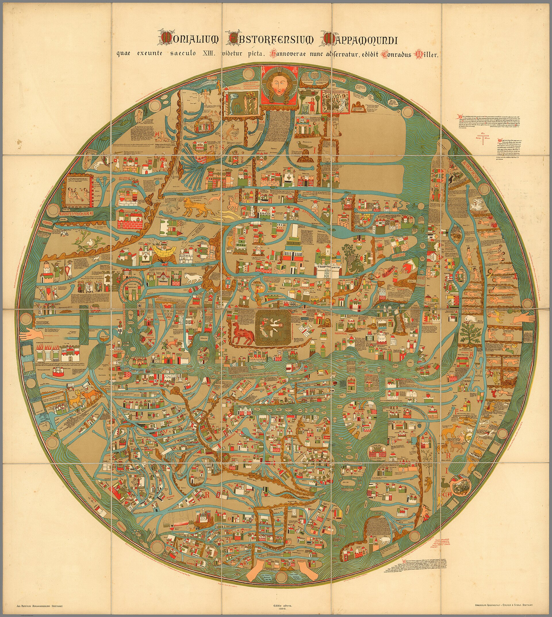
This IS the map described in this record, shown in a pre-1943 printed colour facsimile of the destroyed original (a chromolithograph by Eckstein and Staehle of Stuttgart after the map's 1891 photographic record). The original no longer exists; the colours and some details of this facsimile are its makers' reconstruction.
| Artist | Unknown maker, Benedictine nunnery at Ebstorf (traditionally Gervase of Ebstorf, disputed) |
|---|---|
| Date | c. 1300 (dating disputed: between 1208 and 1250 on the early view; 1320s or early 1330s on the latest proposal) |
| Medium | Ink and colour on parchment, thirty goatskin sheets sewn together (destroyed 1943) |
| Dimensions | About 3.57 m in diameter on a sewn square of thirty skins; sources give the area as about 13 square metres or as over 10 square metres (original destroyed; figures from published accounts) |
| Where it is now | Destroyed 1943. The original burned in the Hanover state archive in the bombing of Hanover of 8-9 October 1943. It survives only in photographs, printed facsimiles, four full-size replicas made from 1950 and modern digital reconstructions.last confirmed |
| Inventory number | None. No inventory number for the original was found in the sources consulted. |
| Attribution | DisputedThe map is unsigned. Full note |
| Object type | Map |
| Period | German, late thirteenth or early fourteenth century |
| Cases | Disputed attribution · Rediscovered · Has a provenance gap |
| Inscriptions | Latin legends throughout, numbering well over a thousand entries; counts differ between sources. Christ's head, hands and feet are drawn at the edges of the disc. Rome appears as a lion. |
| Owners on record | 5 links3 documented, 1 disputed, 1 unknown |
| Sources | 11 cited |
About this record Last verified · 11 sources cited · Change log
On this page 9 sections
ContentsClose
The Ebstorf World Map was the largest medieval world map known: a disc about 3.6 metres across, drawn on thirty goatskins, with Jerusalem at its centre, east at the top and the body of Christ laid around the edge of the world. Found in 1830 in a damp storeroom at the Benedictine convent of Ebstorf, it passed to the state archive in Hanover and was burned there in the bombing of 8-9 October 1943.
It no longer exists. Everything a reader can see today is a reproduction: a black-and-white photographic series of 1891, printed colour facsimiles of 1896 and after, four hand-coloured replicas of the 1950s, and the digital reconstruction by Hartmut Kugler published in 2007. This record separates those layers and says plainly which plate shows which.
Who made it, and when, is still argued. The old attribution to Gervase of Tilbury has been rejected by the editors who know the map best, and a date near 1300 or even the 1320s now has more support than the 1230s.
Provenance
Each link is graded. Documented: a cited source supports it. Disputed: the identification is argued but not established. Unknown: no owner for that span, and the gap is not smoothed into a narrative. The grades in the glossary.
- c. 1300 (date disputed) - 1830Benedictine nunnery at Ebstorf, Lueneburg Heathdisputed
Made, on the prevailing view, in or near the convent at about 1300 or later; the older view puts it in the 1230s. Maker and patron are unknown. A popular-science account says it probably lay in the storeroom since at least 1567. That is an inference, and nothing documents the map's location between its making and 1830.136
- 1830 - 1830Benedictine nunnery at Ebstorfdocumented
Found by the canoness Charlotte von Lassberg in a damp, windowless storeroom, rolled on two poles with altar cloths and processional gear. Mouse damage was already present; a piece of the India quarter was cut out soon after, while the map was on display in the nuns' choir. The 1843 date given in English Wikipedia is not accepted here. Georg Heinrich Pertz is not mentioned by any source consulted.3612
- 1830 - 1835Benedictine nunnery at Ebstorfunknown
Where the map was and who looked after it between the finding and the move to Hanover is not recorded in the sources consulted.1
- 1835 - 1943State archive, Hanover (now Niedersaechsisches Landesarchiv, Hanover site)documented
German Wikipedia says the map was kept at the archive from 1835. Documented only by that tertiary source; the terms of transfer, price and any acquisition act are not recorded. No source fetched places the map in a Hanover museum.1
- 8-9 October 1943 - 8-9 October 1943State archive, Hanoverdocumented
Burned in the bombing of Hanover. The archive's own leaflet records that the west wing was hit by incendiary bombs on 8-9 October 1943 and lists the Ebstorf map among the irrecoverable losses. A regional museum says it lay in a cellar and another says a bunker of the archive. Provenance ends here. The object has no later owner.53
Technical evidence
| Attribution note | The map is unsigned. It was long linked to Gervase of Tilbury and the Ebstorf provost Gervase on the strength of the uncommon name and a shared outlook. Juergen Wilke (2001) and Hartmut Kugler (2007) reject that link and date the map to about 1300, and Georg Hauser (2020) reads the depicted state of Cologne Cathedral as pointing to the 1320s or early 1330s. Armin Wolf (2012) argues that a map of c. 1300 would be a copy of an earlier map by Gervase. Ebstorf is accepted by most as the place of production, but the sources consulted call it probable, not proven. |
|---|---|
| Support | Thirty goatskin sheets sewn together into a square; parchment of sheep or goat is sometimes stated in secondary sources, but the regional museum and the Wieneke replicas point to goatskin.362 |
| Diameter | About 3.57 m (German Wikipedia) or about 3.6 m (regional museum and others).13 |
| Area | About 13 square metres (popular-science account) or over 10 square metres (regional museum). The sources do not agree.63 |
| Orientation | East at the top. Jerusalem at the exact centre. Asia upper half, Europe lower left, Africa along the right edge.13 |
| Damage before 1943 | Mouse damage along the left edge; a piece of about 66 x 50 cm (or 50 x 60 cm) cut from the upper right India quarter, never recovered; north-western Europe made unreadable by rolled storage.361 |
| Photographic record | 1891 black-and-white photographs of the individual sheets, retouched by Sommerbrodt into a 25-sheet atlas (Hanover, Hahn, 1891).46 |
| Replicas | Four full-size hand-coloured replicas on goatskin parchment by Rudolf Wieneke from 1950; at least three survive: Kloster Ebstorf, Lueneburg museum, Plassenburg at Kulmbach.364 |
| Modern edition | Kugler, Die Ebstorfer Weltkarte, 2 vols, Akademie Verlag, 2007: 61 segments, recoloured; estimated about 80 percent faithful to the original.3461 |
| Destruction | Hanover state archive, west wing, incendiary raid of 8-9 October 1943; the archive's own leaflet lists the map among the losses.5 |
Images
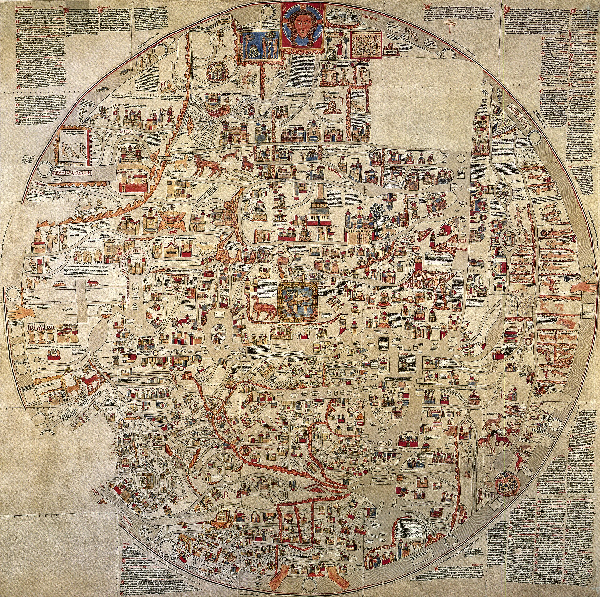
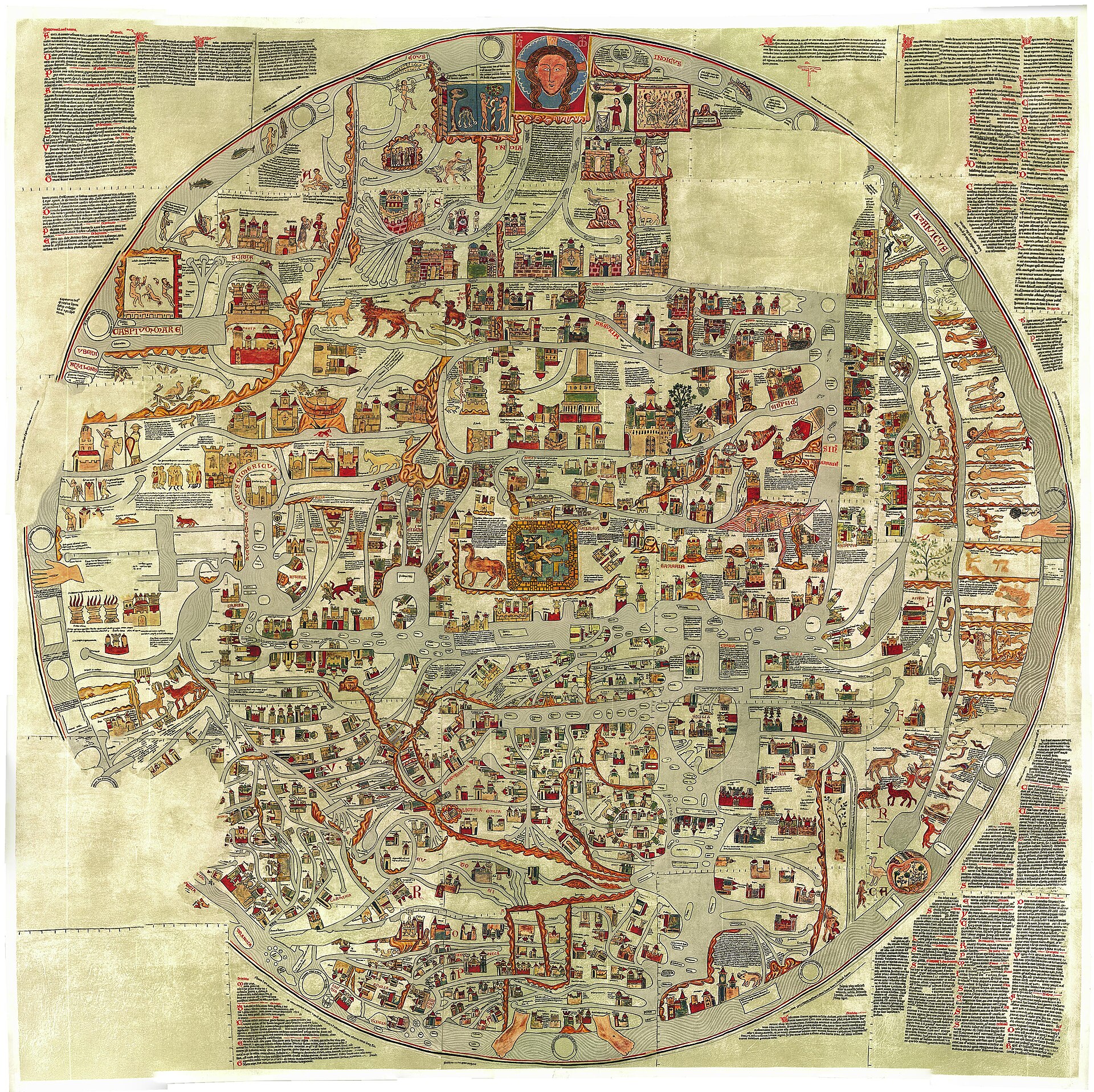
The record in full
Chapter 1A world drawn as a body, and gone
The Ebstorf map was a circular map of the world, east at the top, centred exactly on Jerusalem.
The Ebstorf map was a circular map of the world, east at the top, centred exactly on Jerusalem. Asia filled the upper half, Europe sat in the lower left quarter and Africa ran along the right edge. Around the rim the head of Christ appeared at the top, his hands at the sides and his feet at the bottom, so that the known world was drawn as part of his body. Scholars describe this as the key to the whole design: Pischke's 2014 review says Christ is part of the earth on the map and of central importance to it.
It was made of thirty goatskins sewn into a square and measured about 3.6 metres across. Published figures for its area differ, from over ten to about thirteen square metres. That scale is why it is called the largest map of the medieval world. It is also why it could not be moved or hidden in a crisis, and why a reader should keep one fact in view from the first line: the original was destroyed in 1943. Every image of it is a copy of a copy.
Chapter 2Found in a damp storeroom, 1830
In 1830 a canoness of the convent, Charlotte von Lassberg, found the map in the Benedictine nunnery at Ebstorf near Lueneburg.
In 1830 a canoness of the convent, Charlotte von Lassberg, found the map in the Benedictine nunnery at Ebstorf near Lueneburg. A regional museum account says she found it in a damp, windowless storeroom, rolled on two poles in a bundle of thirty sewn skins, lying with altar cloths and processional equipment from Catholic times. A popular-science account adds that it had probably lain there since at least 1567, when the convent became a Protestant women's foundation. That date rests on a single secondary source and is an inference, not a record.
Damage had already happened. Mice had eaten white gaps along the left edge, which de.wikipedia says included the depiction of Brandenburg. Poor storage left part of north-western Europe unreadable. Then someone cut a piece out of the upper right quarter, the part showing India, while the map was on display in the nuns' choir. Sources give its size as 66 by 50 centimetres (a regional museum and a popular-science account) or about 50 by 60 (de.wikipedia). The regional museum calls the culprit an unknown vandal. The piece has never been recovered.
The brief for this record named the Hanover archivist Georg Heinrich Pertz as the discoverer. None of the sources fetched mentions Pertz. Every source that names a finder names Charlotte von Lassberg. This record therefore does not credit Pertz with the discovery.
Chapter 3Hanover, the archive and 1943
German Wikipedia states that the map was kept at what is now the Niedersaechsisches Landesarchiv in Hanover from 1835.
German Wikipedia states that the map was kept at what is now the Niedersaechsisches Landesarchiv in Hanover from 1835. It is a tertiary source and the statement is not backed in the article by a named document, so it is graded accordingly. How the map left the convent, on what terms, and who arranged it are not recorded in anything fetched. The 1843 date in the brief appears only in the English Wikipedia lead, which says the map was found in 1843 and cites a 2003 conference volume. That date contradicts the 1830 found by every other source and is treated here as an error or as a different event; the sources do not say which. No source fetched places the map in a Hanover museum.
On the night of 8-9 October 1943 an incendiary raid hit the west wing of the state archive building in Hanover. The Lower Saxony state archive's own information leaflet counts the losses: 11,900 charters, 1,200 medieval cartularies, 800 manuscripts and 3,830 shelf-metres of files. It then says that the famous Ebstorf world map was also irrecoverably destroyed. Accounts differ on where in the building it lay. One regional museum says a cellar, another a bunker of the state archive. Sources agree on the year and on the archive. A single catalogue entry gives 1934 as the year of destruction, which conflicts with everything else and is treated as an error. Neither the Ebstorf map nor the loss of it has any market history: it was never sold.
Chapter 4What was drawn on it
The map carried a great many entries. German Wikipedia counts over 2,300 text and image entries; a further passage of the same article lists about 1,500 text entries, 534 cities, 500 buildings, 160...
The map carried a great many entries. German Wikipedia counts over 2,300 text and image entries; a further passage of the same article lists about 1,500 text entries, 534 cities, 500 buildings, 160 bodies of water, 60 islands and mountain ranges, 45 humans and mythical creatures and about 60 animals. A popular-science account gives lower counts for several of these categories. Counts differ because each author counted a different reconstruction of a damaged and unreadable original. They are not measurements of the lost object.
The content came from books. Kugler traced most of the text to Isidore of Seville's Etymologiae and Honorius's Imago mundi. The map mixes biblical and pagan history, shows Adam and Eve holding the forbidden apple, and draws peoples and beasts from the encyclopaedic tradition. Jerusalem is drawn as the centre of the world and the east, where Paradise lay, is at the top. The surviving accounts record no patron's contract and no description of how the nuns used it. Whether it hung in the choir, served for teaching, or was kept as a treasure is not established by the sources fetched.
The Christ-body design is an argued reading by modern scholars of how the disc is composed, not a statement recorded from the makers. The map has no hidden programme beyond the ordinary salvation-history geography of its age.
Chapter 5Who made it, and when
The map is unsigned. The older view put it in the 1230s and gave it to Gervase of Ebstorf, provost of the convent in the early thirteenth century, or to the jurist Gervase of Tilbury, author of the...
The map is unsigned. The older view put it in the 1230s and gave it to Gervase of Ebstorf, provost of the convent in the early thirteenth century, or to the jurist Gervase of Tilbury, author of the Otia Imperialia for Emperor Otto IV. The arguments for Tilbury are the rare name Gervase in northern Germany and a similar outlook. Other issues in dispute are the date and the age of Tilbury.
The editors of the Oxford Medieval Texts edition of the Otia, as quoted in Wikipedia, call the identification an attractive possibility but say it needs too many improbable assumptions. Evelyn Edson, quoted in the Wikipedia article on Gervase of Ebstorf, says the link can only remain hypothetical.
The later view comes from handwriting and content. Wilke (2001) argued from comparison of hands for c. 1300 and found no evidence linking the map or the convent to Gervase. Kugler (2007) agreed on c. 1300, found no demonstrable tie to the Otia, and suggested book models rather than a large-format original. Hauser (2020), reading the state of Cologne Cathedral drawn on the map, proposed the 1320s or early 1330s.
Armin Wolf set out the other side in Imago Mundi in 2012, in an article titled The Ebstorf Mappamundi and Gervase of Tilbury: The Controversy Revisited. The abstract says the date has been controversial for decades, with an early camp putting it between 1208 and 1250 and a late camp near 1300. It offers a compromise: if the surviving map is of c. 1300, it should be seen as a copy of Gervase's earlier map. German Wikipedia adds that Wolf has proposed an older template made for Otto IV and that this cannot be ruled out. Full text of Wolf's argument was not available for this record.
Chapter 6Photographs, facsimiles and replicas: how the map survives
What exists today is a chain of reproductions, and each link changes the object.1891.
What exists today is a chain of reproductions, and each link changes the object.
1891. Black-and-white photographic reproductions of the separate sheets were made. They were blurred and uneven, so the philologist Ernst Sommerbrodt went over the faint lettering in black ink and shaded the figures in grey. The result was a 25-sheet atlas published at Hanover in 1891. The 1891 plates are the best surviving record of the original and the base for almost everything after.
1896. A new edition was hand-coloured on the evidence of the original and printed in sixteen colours on a single sheet of about one square metre. A popular-science account says the editor took considerable liberties and the style departs from the original. The plate used as the lead image here is a Stuttgart colour lithograph titled Monialium Ebstorfensium mappa mundi, edited by Konrad Miller; its Commons record names the second edition of 1898 and the Rumsey catalogue entry gives a 101 cm disc. It is very probably this Stuttgart production family, but the sources consulted do not tie Miller's name explicitly to the 1896 entry.
1930. A roll map was painted in tempera over prints of the 1891 plates, with considerable losses of text and image. It now hangs in the Ebstorf agricultural school.
1950 onward. The graphic artist Rudolf Wieneke printed four full-size copies on goatskin parchment from the 1891 template and coloured them by hand. They are described in the sources as made in 1950 or between 1950 and 1953. One is at Kloster Ebstorf and one at the Lueneburg museum. One hangs in the Landschaftsmuseum Obermain at the Plassenburg above Kulmbach; the town of Kulmbach bought it in 1962 because the Plassenburg is the only castle the map shows. The fourth, according to the regional museum, was given by the Reemtsma firm to the Greek royal couple and is probably lost. German Wikipedia instead lists Hanover as a location. The sources conflict on this and this record reports both.
Digital. From the 1980s Martin Warnke at Lueneburg digitised the map and in the 1990s made a coloured version for the internet, now the Leuphana University project EBSKART. In 2007 the Erlangen Germanist Hartmut Kugler published the two-volume Die Ebstorfer Weltkarte (Akademie Verlag): an atlas volume and a volume of studies and commentary. He scanned the 1891 plates at high resolution, retranslated the texts, recoloured the map from several sources and divided it into 61 segments. He estimates that his reconstruction is about 80 percent faithful to the original.
Chapter 7What the plates on this page show
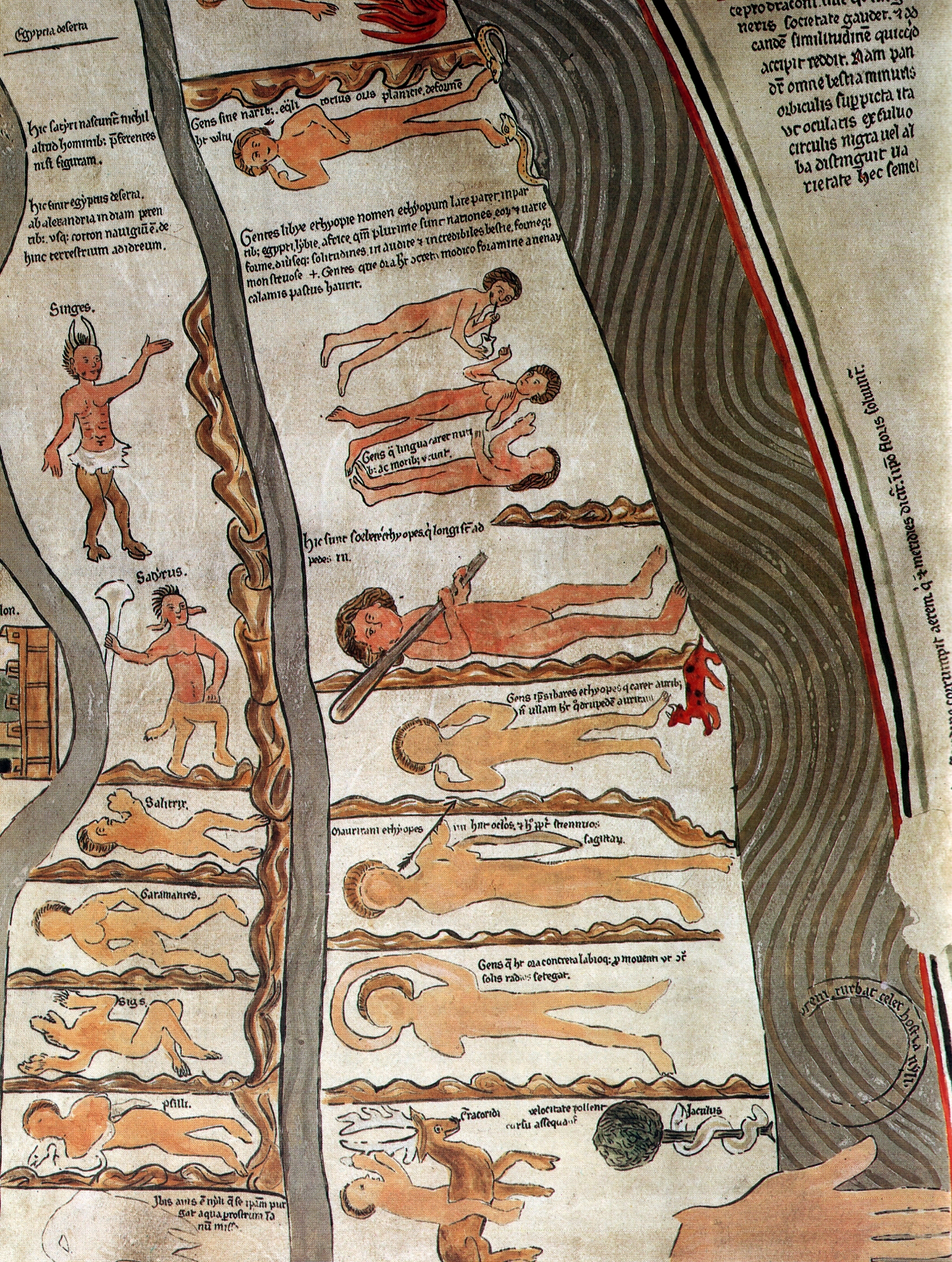
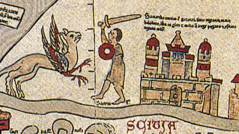
None of the plates shows the object. The lead plate is a printed facsimile made before the destruction.
None of the plates shows the object. The lead plate is a printed facsimile made before the destruction. The other plates are modern reproductions: images that Commons or the sites behind them describe as stitched from, or related to, the Leuphana digital reconstruction. A pale page or a clean, even colour in them is the reconstruction's colour, not the vellum.
The Hereford Mappa Mundi and the Psalter map are different objects. Hereford survives and has its own record on this site. Nothing on this page should be read as describing either of them, and the modern Ebstorf replicas are copies, not the original.
Chapter 8What is unresolved
Date, author and patron are open. The route from the convent to the state archive is undocumented in everything consulted.
Date, author and patron are open. The route from the convent to the state archive is undocumented in everything consulted. The destruction is certain, but the exact place in the building where the map lay is reported three ways. The piece cut from the India quarter has never been found, and the numerical counts of what the map contained depend on whose reconstruction is counted. The record ends on that line: the object ends in 1943 and the argument continues without it.
The artist
The Benedictine nunnery at Ebstorf and the unknown maker of the map
No name is signed on the map. What is known is the house it was found in: a Benedictine women's convent on the Lueneburg Heath, 25 kilometres or so south of Lueneburg, which became a Protestant women's foundation in 1567 and still exists as Kloster Ebstorf. Who inside or near it conceived the map is the open question of its scholarship.
Related works
| Work | Relation | Where it is |
|---|---|---|
| Hereford Mappa Mundi Unknown | A different object: the other great medieval world map, which survives Live on this site as hereford-mappa-mundi. Dated c. 1300 on palaeographic and dendrochronological grounds. Not to be confused with the Ebstorf map. | Hereford Cathedral, Hereford, England |
| Ebstorf replica (Wieneke, 1950s) Rudolf Wieneke | Full-size hand-coloured copy on goatskin parchment, from the 1891 plates One of four made from 1950. A copy, not the original. | Kloster Ebstorf |
| Ebstorf replica (Wieneke) at Lueneburg Rudolf Wieneke | Second replica of the 1950 set Named in two regional sources. | Lueneburg museum |
| Ebstorf replica (Wieneke) at the Plassenburg Rudolf Wieneke | Third replica; bought by the town of Kulmbach in 1962 The Plassenburg is the only castle drawn on the map. | Landschaftsmuseum Obermain, Plassenburg, Kulmbach |
| Die Ebstorfer Weltkarte, 2 vols Hartmut Kugler (ed.) | Scholarly reconstruction and commentary 61 segments; estimated about 80 percent faithful. | Akademie Verlag, Berlin, 2007 |
| Ebstorf roll map of 1930 Unknown | Tempera roll painted over the 1891 plates, with considerable losses Per the regional museum. | Ebstorf agricultural school (Landbauschule) |
Open questions
- Who conceived and drew the map, and for whom? Gervase of Ebstorf, Gervase of Tilbury and an anonymous Ebstorf nun have all been proposed, and the sources consulted contain no signature or contract.
- When was it made? The range runs from about 1208-1250 on the early view, through c. 1300 (Wilke, Kugler), to the 1320s or early 1330s (Hauser 2020). Wolf's compromise, a c. 1300 copy of an earlier map, has not been settled.
- How and when did it go from the convent to the state archive in Hanover? German Wikipedia gives 1835. The route, the terms and any receipt are not recorded in the sources consulted.
- Was the 1830 finder the only person involved? The brief for this record named Pertz; no fetched source mentions him.
- What was the 1843 date in the English Wikipedia lead? It conflicts with 1830 and 1835 and is unexplained.
- Where exactly was the map when it burned: cellar, bunker or another room? The archive leaflet names only the burning west wing.
- What happened to the fourth Wieneke replica, said to have gone to the Greek royal couple? German Wikipedia lists Hanover instead.
- Who cut the piece from the India quarter, when, and where is it?
Questions about this object
What is The Ebstorf World Map (Ebstorfer Weltkarte)?
The Ebstorf World Map (Ebstorfer Weltkarte) is a map, dated c. 1300 (dating disputed: between 1208 and 1250 on the early view; 1320s or early 1330s on the latest proposal). Medium: Ink and colour on parchment, thirty goatskin sheets sewn together (destroyed 1943).
Who made The Ebstorf World Map (Ebstorfer Weltkarte), and is the attribution settled?
The attribution to Unknown maker, Benedictine nunnery at Ebstorf (traditionally Gervase of Ebstorf, disputed) is recorded here as disputed. The map is unsigned. It was long linked to Gervase of Tilbury and the Ebstorf provost Gervase on the strength of the uncommon name and a shared outlook. Juergen Wilke (2001) and Hartmut Kugler (2007) reject that link and date the map to about 1300, and Georg Hauser (2020) reads the depicted state of Cologne Cathedral as pointing to the 1320s or early 1330s. Armin Wolf (2012) argues that a map of c. 1300 would be a copy of an earlier map by Gervase. Ebstorf is accepted by most as the place of production, but the sources consulted call it probable, not proven.
Where is The Ebstorf World Map (Ebstorfer Weltkarte) now?
Destroyed 1943. The original burned in the Hanover state archive in the bombing of Hanover of 8-9 October 1943. It survives only in photographs, printed facsimiles, four full-size replicas made from 1950 and modern digital reconstructions. Inventory number None. No inventory number for the original was found in the sources consulted.. Last confirmed 16 November 2026. Niedersaechsisches Landesarchiv, Hanover: the archive's own account of the October 1943 raid names the Ebstorf map among its losses.
What is still unknown about The Ebstorf World Map (Ebstorfer Weltkarte)?
Who conceived and drew the map, and for whom? Gervase of Ebstorf, Gervase of Tilbury and an anonymous Ebstorf nun have all been proposed, and the sources consulted contain no signature or contract.
Sources
- 1German Wikipedia, 'Ebstorfer Weltkarte'. To be replaced by Kugler's 2007 edition and Wolf's articles. de.wikipedia.org/wiki/...
- 2English Wikipedia, 'Ebstorf Map'. To be replaced by the cited publications. en.wikipedia.org/wiki/...
- 3Landschaftsmuseum Obermain pages, 'Die Ebstorfer Weltkarte' (regional museum site, Kulmbach): the finding in 1830, the damage, the 1891 to 1962 reproduction chain, the Wieneke replicas and the Plassenburg copy, and Kugler's 61 segments. Regional museum source; the page cites Kugler 2007 and Hahn-Woernle. landschaftsmuseum.de/Seiten/...
- 4Landschaftsmuseum Obermain, 'Ebstorfer Weltkarte - Links: Aus der Geschichte der Karte', dated list from c. 1300 to 2006, naming Wieneke, Warnke and Kugler and the 1943 loss in the archive bunker. landschaftsmuseum.de/Seiten/...
- 5Niedersaechsisches Landesarchiv, information leaflet on the Hanover site (building history), recording the 8-9 October 1943 incendiary hit on the west wing and the loss of the Ebstorf world map with 11,900 charters, 1,200 cartularies, 800 manuscripts and 3,830 shelf-metres of files. nla.niedersachsen.de/download/...
- 6wissenschaft.de, 'Die schoene Ebstorferin' (after Michael Zick, Bild der Wissenschaft 11/2007): the 1830 find, probable storage since 1567, the cut-out, 1891, 1896, 1930, 1950 reproductions, Kugler's edition and dating. Popular-science source. wissenschaft.de/artikel/...
- 7English Wikipedia, 'Gervase of Ebstorf'. To be replaced by primary scholarship. en.wikipedia.org/wiki/...
- 8Armin Wolf, 'The Ebstorf Mappamundi and Gervase of Tilbury: The Controversy Revisited', Imago Mundi 64(1), 2012, pp. 1-27, abstract only as relayed by a search result; full text not read. tandfonline.com/doi/...
- 9G. Pischke, 'The Ebstorf Map: tradition and contents of a medieval picture of the world', History of Geo- and Space Sciences 5, 155-161, 2014, abstract page only (Christ as part of the earth). hgss.copernicus.org/articles/...
- 10Medieval Histories, 'The Ebstorf map': a general account with the 1830 find, the Gervase question and the 1951-1953 reproductions. Secondary. medieval.eu/ebstorf-map
- 11Wikimedia Commons file pages for the plates (licences read from the Commons API: public domain for the lead, Ebstorfer Weltkarte 2, Ebstorfer-stich2, the south detail and the Samarcha fragment). commons.wikimedia.org/wiki/...
Last verified · Published
Change log
16 November 2026 - Record created at the house standard: researched narrative, technical evidence, maker dossier, graded provenance chain, prices with hammer and premium separated, related works, open questions and sources.