Tabula Peutingeriana
Unknown copyist, south German or Alsatian scriptorium · Copy: c. 1200 (a disputed alternative hypothesis proposes 1265). The lost Roman original it reproduces is of contested date; proposals in current scholarship range from an Augustan-era survey revised in the 4th-5th century, to c. A.D. 300, to a Hellenistic foundation revised as late as c. A.D. 435.
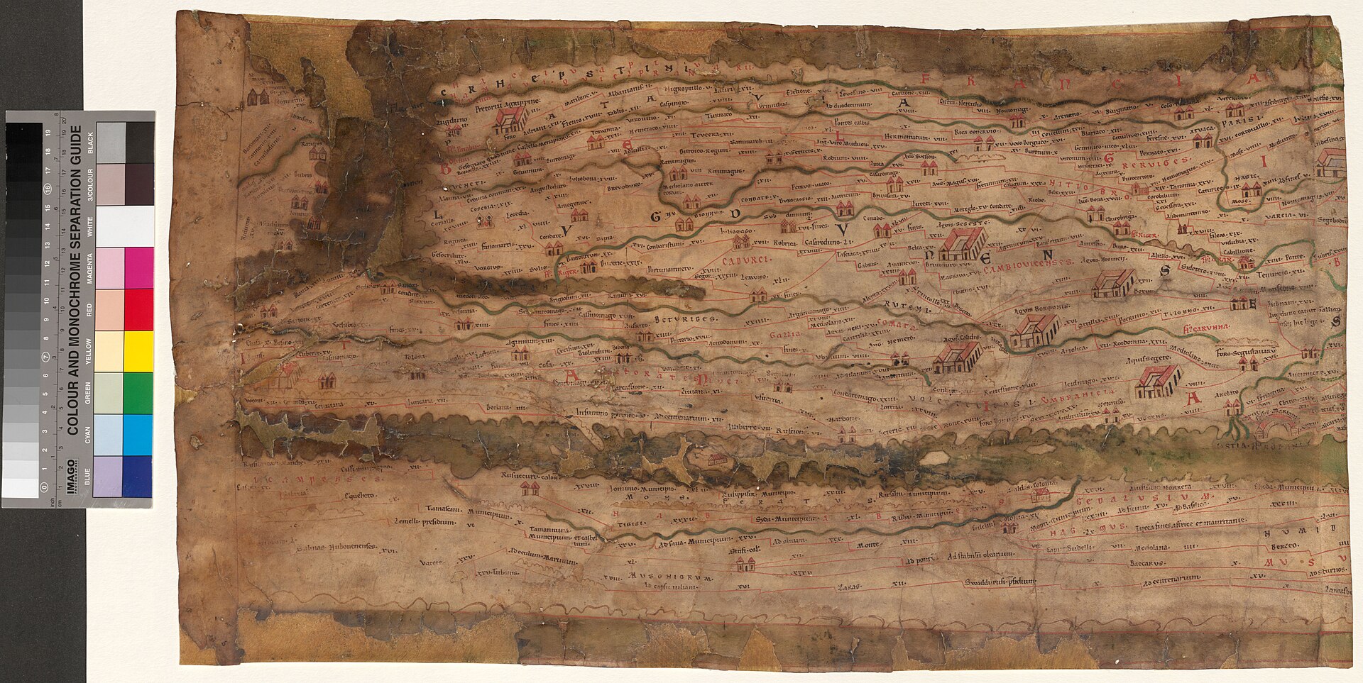
One of the eleven surviving parchment segments of the Tabula Peutingeriana, photographed from the Austrian National Library's own digitisation of Codex Vindobonensis 324.
| Artist | Unknown copyist, south German or Alsatian scriptorium |
|---|---|
| Date | Copy: c. 1200 (a disputed alternative hypothesis proposes 1265). The lost Roman original it reproduces is of contested date; proposals in current scholarship range from an Augustan-era survey revised in the 4th-5th century, to c. A.D. 300, to a Hellenistic foundation revised as late as c. A.D. 435. |
| Medium | Brown ink, with roads marked in red, on a parchment scroll of 11 surviving sheets (originally 12) glued end to end, now cut apart and mounted separately between glass |
| Dimensions | Approximately 675 to 680 cm long by 33 to 34 cm high across the 11 surviving segments; sources vary by a few centimetres in both figures |
| Where it is now | Austrian National Library (Osterreichische Nationalbibliothek), Vienna, Department of Manuscripts, Autographs and Closed Collectionslast confirmed |
| Inventory number | Codex Vindobonensis 324 (Cod. 324 HAN MAG) |
| Attribution | UnknownNo document names the person who made this copy. Full note |
| Object type | Map |
| Period | Medieval copy, German, c. 1200, after a Roman itinerary map of disputed date |
| Cases | Has a provenance gap |
| Inscriptions | Roughly 3,500 to 3,700 place names, distances and route notations in Latin, plus later annotations by early modern readers; no maker's signature or colophon survives |
| Owners on record | 8 links4 documented, 3 disputed, 1 unknown |
| Sources | 19 cited |
About this record Last verified · 19 sources cited · Change log
On this page 9 sections
ContentsClose
An eleven-sheet parchment scroll, roughly 6.8 metres long and about 34 centimetres high, copied around the year 1200 from a lost Roman map of the road network of the cursus publicus. It is the only substantially complete map to survive from antiquity in any form, in however many removes, and its westernmost sheet, which would have shown Britain, Iberia and Morocco, has been missing since at least the sixteenth century.
The map takes its common name from the Augsburg humanist Konrad Peutinger, who never made it, published it, or is even reliably documented as having sought it out; he simply inherited it, by gift, from the man who found it. It passed through his family for two centuries, was bought for Prince Eugene of Savoy in the early eighteenth century, and entered the Habsburg imperial library by 1738, where, as the Austrian National Library, it remains: kept in a safe, its date and purpose still argued over in print by named scholars who flatly disagree with one another, and its own Napoleonic-era history, a period every institutional account of it passes over in silence, left here as an open gap rather than filled with a guess.
Added to UNESCO's Memory of the World Register in 2007, it is currently the subject of an active multispectral imaging project that has already recovered at least one place name invisible to the naked eye, confirming a transcription made by a sixteenth-century reader four hundred years before the technology existed to check it.
Provenance
Each link is graded. Documented: a cited source supports it. Disputed: the identification is argued but not established. Unknown: no owner for that span, and the gap is not smoothed into a narrative. The grades in the glossary.
- 1st century BCE - 5th century CE (disputed) -Unknown; a lost Roman itinerary map, the ultimate source of this copydisputed
The date, authorship and purpose of the lost Roman original are all genuinely contested. Proposals in current scholarship include a map descended from an Augustan-era survey associated with Marcus Vipsanius Agrippa and revised in the 4th or 5th century; Konrad Miller's dating to A.D. 365-366, based on the map's emphasis on Rome, Constantinople and Antioch as the three imperial residences of that moment; Richard Talbert's 2010 case for a Tetrarchic display document of c. A.D. 300, made for a public space in an imperial palace rather than for practical travel; and Michael Rathmann's ongoing case for a Hellenistic foundational form, continuously revised down to about A.D. 435. No single position is the settled consensus.1510111215
- c. 1200 (disputed alternative: 1265) -Unknown copyist, probably working in the south German region or Alsacedisputed
The surviving manuscript is a copy of the lost Roman original made by a single unnamed individual, described by reviewers of the paleographic scholarship as an artist rather than a scribe, who copied the map layer by layer rather than by pricking or tracing. The best-supported dating is approximately A.D. 1200, in the south German region or Alsace; a more specific, disputed hypothesis assigns the work instead to a monk in Colmar in 1265. The twelfth, westernmost sheet was already missing by the time the map resurfaces in the documented record.515
- by 1494 or 1507 (disputed) - 1507-1508Conrad Celtes (1459-1508), humanist and university teacher, Viennadisputed
Celtes is credited with finding the scroll in a library, most often identified as Worms, though sources are not fully consistent and some instead describe an unspecified monastery library in southern Germany. Some modern scholarship treats the acquisition as an unauthorized removal rather than a legitimate discovery, as part of a wider pattern of manuscript acquisition associated with the circle around Emperor Maximilian I; this record notes that view without adopting it as settled fact. Celtes gave or promised the map to Konrad Peutinger in Augsburg in the summer of 1507 and confirmed the gift in his will, which took effect on his death in February 1508.71516
- 1508 - c. 1714Konrad Peutinger (1465-1547) and his descendants, Augsburgdocumented
The map remained privately owned by the Peutinger family in Augsburg for more than two centuries. Konrad Peutinger, Augsburg's town clerk from 1497 and a close associate of Emperor Maximilian I, was among the first German scholarly epigraphists; the map became permanently associated with his name and library even though he neither made nor published it. By the 1590s, family access had passed to the Augsburg patrician Marcus Welser, whose manuscript copies were engraved for Abraham Ortelius and published in Antwerp in 1598 by Johannes Moretus as the first printed edition, already titled from the Peutinger library. The manuscript itself was sold out of the family around 1714 by Ignaz Desiderius Peutinger, dean of the collegiate chapter at Ellwangen, to the book dealer Paul Kuz.47161718
- 1714/1715/1717 (sources disagree on the exact year) - 1736Eugene, Prince of Savoy (1663-1736)documented
The map was acquired for Prince Eugene of Savoy through the scholar and agent Karl Gustav Heraus, reportedly for 100 ducats, a figure repeated across secondary sources but not traced here to a contemporary receipt. It joined Eugene's library at the Winter Palace in Vienna, a collection of roughly 15,000 volumes by the time of his death.467
- 1736 - 1738Emperor Charles VI, for the Imperial Court Library (Hofbibliothek), Viennadocumented
Prince Eugene died on 21 April 1736. His library, the Bibliotheca Eugeniana, was purchased from his heir and incorporated into the Habsburg Imperial Court Library; the transfer was completed by 1738, the date the library's own records treat as the map's entry into what is now the Austrian National Library.3467
- 1738 - 1809-1815 (unresolved)Habsburg Imperial Court Library (Hofbibliothek), Viennaunknown
Every institutional source consulted describes the map's custody at the Hofbibliothek as continuous from 1738 onward, without mentioning any interruption. That silence is worth stating rather than passing over, because the library is separately and reliably documented to have lost manuscripts and books to French forces during the 1809 occupation of Vienna, when Napoleon's director-general of museums, Dominique Vivant Denon, personally selected material from the Hofbibliothek for removal to Paris, an episode substantial enough to be the subject of a dedicated early study (Ferdinand Mencik's dissertation on the removal of manuscripts from the Court Library by the French in 1809). At least one other named treasure of the same library, the Hours of Mary of Burgundy, is documented elsewhere as seized in 1809 and returned to Vienna in 1815 after Waterloo. No source consulted here states that the Tabula Peutingeriana was among the items removed in 1809, and none states affirmatively that it stayed in Vienna throughout. This record treats the period as an unresolved gap rather than asserting either outcome.346789
- 1815 (or, if no gap occurred, 1738) - presentAustrian National Library (Osterreichische Nationalbibliothek), Viennadocumented
Whatever the resolution of the 1809-1815 question, the map has certainly been part of the library's holdings, as Codex Vindobonensis 324, since at least the restoration of normal conditions after 1815, and the library's own current cataloguing and the UNESCO Memory of the World nomination file both describe it as in place today. It was divided into individually mounted segments in 1863 and has been stored between glass since 1937; it is kept in a safe in the manuscripts depot, with access normally restricted to the facsimile.13467
Technical evidence
| Attribution note | No document names the person who made this copy. Paleographic analysis points to a single skilled individual, described by reviewers of the modern scholarship as an artist rather than a scribe, working around A.D. 1200, probably in the south German region or Alsace. A more specific but disputed hypothesis, current in some secondary literature, assigns the work instead to a monk in Colmar in 1265. The lost Roman map this copy reproduces is itself of contested date and authorship; see the narrative sections below for the competing scholarly positions, none of which commands consensus. |
|---|---|
| Format | A parchment scroll (volumen), of 11 surviving sheets glued end to end (originally 12), now cut apart and mounted separately between glass. The choice of an archaic scroll format, at a date when the codex was the standard book form, appears to be a deliberate imitation of an ancient book's physical shape rather than only its content.134 |
| Dimensions | Approximately 675 to 680 cm long by 33 to 34 cm high across the 11 surviving segments. Figures vary slightly between the library's own sources and the UNESCO nomination file; this record gives the range rather than a single figure.13467 |
| Script and colour | Main text in brown ink; roads and some emphasis marked in red.7 |
| Copying method | Paleographic analysis indicates the map was copied layer by layer in a single sustained campaign, not assembled by pricking through a template or by tracing. Reviewers of this finding describe the copyist as an artist rather than a scribe.5 |
| Named features | Approximately 3,500 to 3,700 place names, rivers, mountains and other features are marked, the range reflecting different counting conventions used by the modern commentary project working on the map.1011 |
| Original extent | The scroll originally comprised 12 sheets. The twelfth, westernmost sheet, which would have shown Britain, Iberia and Morocco, was already missing by the time the gap was first noted, in 1526, and has never been located.14615 |
| 1863 conservation | The roll was divided into individually mounted segments, the first significant intervention in its physical form since it was made.6 |
| 1937 conservation | The individual segments have been stored between glass plates since this date.16 |
| Current storage and access | Kept in a safe in the manuscripts depot of the Austrian National Library. Access for researchers and the public is normally restricted to the facsimile.1 |
| Ongoing imaging research | Multispectral imaging, applied since 2022 in test form and expanded in a 2026 collaboration with the University of Hamburg, is recovering pigment that has faded or chemically corroded, including green copper-based ink used for water features.12 |
Images

The record in full
Chapter 1What it is
The Tabula Peutingeriana is a schematic map of the Roman road network, drawn in brown ink with the roads themselves picked out in red, on a parchment scroll made up of eleven sheets glued end to end.
The Tabula Peutingeriana is a schematic map of the Roman road network, drawn in brown ink with the roads themselves picked out in red, on a parchment scroll made up of eleven sheets glued end to end. Laid flat it runs to roughly 6.75 to 6.8 metres in length and only about 33 to 34 centimetres in height, a proportion so extreme that the landmass it depicts, stretching from Britain in the west to India in the east, is squeezed into a long, narrow band in which north-south distances are wildly compressed relative to east-west ones. It is not a map in the modern sense of a scaled projection of territory; it is closer to a diagram, more like a modern transit map than an atlas page, built to show connections and distances along routes rather than accurate shapes of coastlines or borders.
The choice of a scroll, rather than a bound codex, is itself a decision worth noticing. By the year 1200, when the surviving copy was made, the codex had been the standard form for a serious book in Latin Christendom for the better part of a millennium. A scroll was an antiquarian gesture, imitating the volumen format in which the Romans themselves would have kept such a document. Whoever made this copy chose to preserve not only the content of an ancient map but the physical shape of an ancient book.
Today it is not on public display. It is kept in a safe in the manuscripts depot of the Austrian National Library in Vienna, and the library's own risk assessment for its UNESCO nomination states plainly that access for researchers and the public is restricted to the facsimile. Apart from some damage to the parchment, it is described in that same nomination file as being in good condition.
Chapter 2How to read it
The map marks something on the order of 3,500 to 3,700 named features: towns, rivers, mountain ranges, provinces, and distances along the roads connecting them, all in Latin.
The map marks something on the order of 3,500 to 3,700 named features: towns, rivers, mountain ranges, provinces, and distances along the roads connecting them, all in Latin. A modern project working to re-catalogue every one of these names, described further below, gives the range as running to roughly 3,700 depending on how variant spellings and repeated entries are counted.
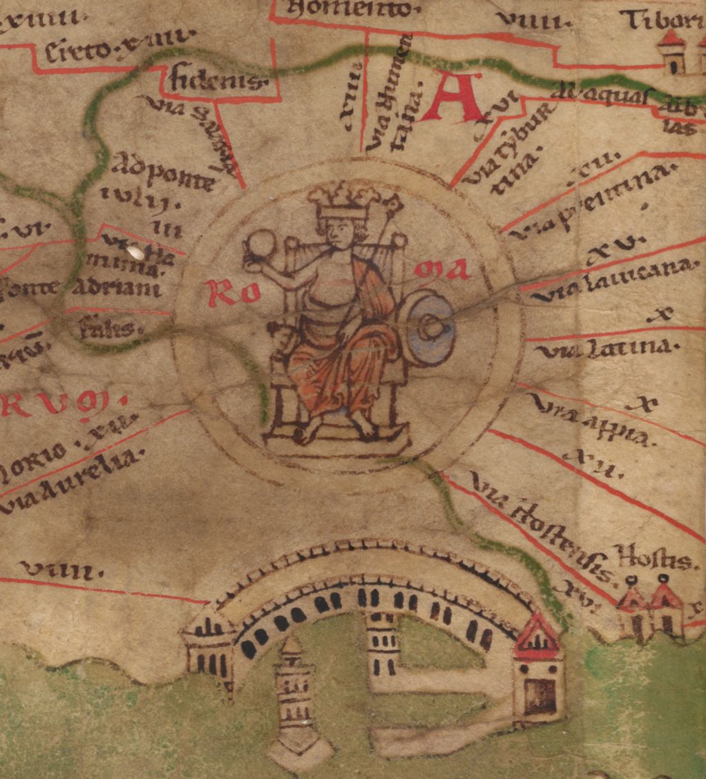
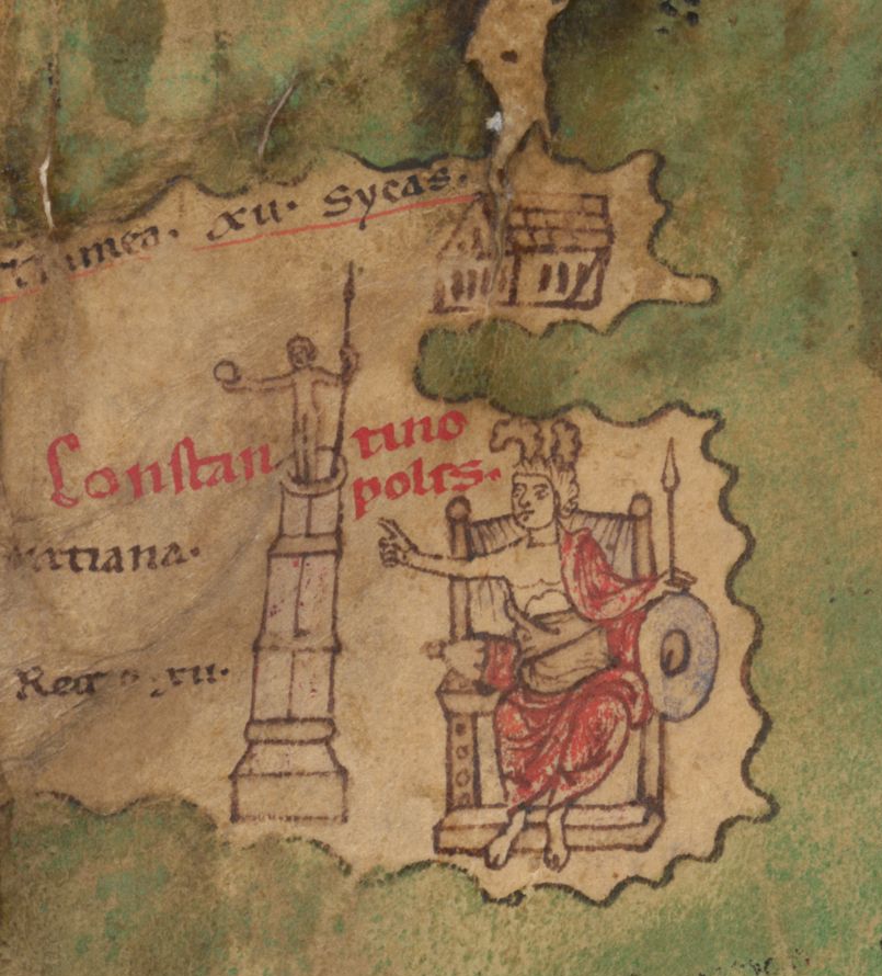
Most settlements are marked with a simple vignette, a small drawing of a building or a pair of towers. A handful of cities are given a different, more elaborate treatment: an enthroned, crowned figure, used for Rome, Constantinople and Antioch. Scholars on more than one side of the dating dispute over the lost original treat this detail as evidence for when that original was last substantively revised, because Constantinople did not exist under that name, and was not one of the empire's leading cities, until after Constantine founded it in the fourth century. Exactly what conclusion to draw from the detail, however, is contested, and is addressed in the next section.
Chapter 3The lost Roman original: a genuinely open dispute
Everyone agrees that the object in Vienna is a medieval copy of something older.
Everyone agrees that the object in Vienna is a medieval copy of something older. Almost nothing else about that older original is agreed. At least four incompatible scholarly positions on its date, authorship and purpose are current in print, and this record states them as a live dispute rather than picking a winner.
The older consensus, still repeated in general reference works, holds that the map descends from a survey associated with Marcus Vipsanius Agrippa under the emperor Augustus, revised at least once more in the fourth or fifth century to bring it up to date. Working within a similar framework in the early twentieth century, the German scholar Konrad Miller argued for a specific revision date of A.D. 365 to 366, reasoning from the prominence given to Rome, Constantinople and Antioch as the three imperial residences of that exact moment. Another early twentieth-century scholar, Wilhelm Kubitschek, argued instead that the underlying material was no later than the reign of Caracalla, in the early third century.
Richard Talbert's 2010 monograph, Rome's World: The Peutinger Map Reconsidered, argues for something different in kind, not just in date. Talbert dates the lost original to the Tetrarchy under Diocletian, around A.D. 300, and argues that it was never a practical aid for travelers or the cursus publicus at all, but a display document: part of a larger decorative scheme for a public space, probably an apse, inside an imperial palace, meant to celebrate the Tetrarchs' restoration of order across the empire rather than to help anyone find a road. Reviewing the book for the Bryn Mawr Classical Review, Renate Burri credited Talbert with a genuinely fresh reading of the evidence, while also noting that his case for centering Rome on the original map, on which several of his other conclusions depend, is treated as settled throughout the book without, in her words, ever being carefully argued with reference to evidence.
A further, ongoing position comes from Michael Rathmann's research group at the Katholische Universitat Eichstatt-Ingolstadt, which is engaged in a long-running, DFG-funded project to produce a full modern commentary on the map. That project's own published framing proposes a Hellenistic foundational form for the map, predating the Roman imperial period altogether, treats the surviving document as a knowledge repository and memory medium rather than a single finished composition, and understands it as a work in progress whose purpose changed as it was revised, down to a last substantive revision the project dates to around A.D. 435.
Finally, a 2014 monograph by Emily Albu takes yet another line, arguing that the map is substantially a thirteenth-century political production rather than a faithful copy of anything much older: a document made for the German Hohenstaufen court, part of an argument for the Hohenstaufens' own claim to inherit Roman imperial authority, notably against a rival papacy. A review of Albu's book notes that part of her case rests on the selective absence of major ancient cities, Alexandria among them, that a faithful Roman original would be expected to include.
None of this is resolved. A reader looking for a single settled date for the lost original will not find one in current scholarship, and this record has not tried to manufacture one.
Chapter 4The missing twelfth sheet
The surviving scroll has eleven sheets. Nearly every source consulted for this record agrees that it originally had twelve, and that the missing sheet, at the western end, would have shown Britain...
The surviving scroll has eleven sheets. Nearly every source consulted for this record agrees that it originally had twelve, and that the missing sheet, at the western end, would have shown Britain, the Iberian peninsula and Morocco. What is agreed stops there.
The earliest evidence that a sheet is missing is not a document describing its contents but an inference: the German humanist Michael Hummelberg, examining the map in 1526, observed that if the maker had intended to place Rome at the exact centre of the composition, as later scholars including Talbert continue to assume, the map as it survives is unbalanced, and would need three further sheets at the western end to be symmetrical. That is an argument from geometry, not a record of what was actually drawn there. No transcription, sketch or independent description of the lost sheet's actual content is known to survive.
In 1898, Konrad Miller produced a hypothetical reconstruction of the missing western sheet for his facsimile edition, restoring Britain, Iberia and Morocco to the map on the basis of comparison with other ancient geographical sources. That reconstruction is a scholarly hypothesis about what a lost sheet probably contained, built more than thirteen centuries after the sheet itself was likely lost; it is not evidence of what was actually there, and this record treats it as exactly that.
Chapter 5How the copy was made
The person who made the object now in Vienna left no name behind.
The person who made the object now in Vienna left no name behind. What paleographic analysis has established, and what Talbert's 2010 study makes a point of, is how they worked: the map was copied layer by layer, in a single campaign, rather than assembled by pricking through a template or tracing an outline first and filling in detail afterward. Reviewing this finding, Renate Burri summarized it as evidence that the copy was produced by a single individual, an artist rather than a scribe, working around A.D. 1200, supposedly in the south German region or Alsace.
That is the best-supported current view. A different, more specific hypothesis, current in some secondary literature, holds instead that the copy was made by a monk in Colmar in 1265; this record has not been able to verify that claim against the primary paleographic scholarship and flags it as disputed rather than adopting it.
Either way, the copyist chose to preserve the scroll format of an ancient book at a moment when nearly every other serious text in circulation was being copied into codices, and chose a technique, continuous layer-by-layer drafting, associated more with drawing than with routine text transcription. Both choices suggest someone who understood the object as a picture to be reproduced whole, not a text to be copied out.
Chapter 6Discovery, and a disputed theft
The map re-enters the documented historical record with the German humanist Conrad Celtes, a university teacher in Vienna.
The map re-enters the documented historical record with the German humanist Conrad Celtes, a university teacher in Vienna. Sources are not consistent about exactly where or when Celtes came across it: most name a library in Worms, though some accounts instead describe an unspecified monastery library in southern Germany. This record states that disagreement rather than resolving it in favour of one place.
Whether Celtes acquired the map legitimately is also disputed. Several modern scholars, working within a broader argument about how manuscripts moved into and out of German libraries during this period, treat Celtes's acquisition as effectively an unauthorized removal rather than a straightforward discovery, connected to a wider pattern of manuscript-gathering associated with the circle around Emperor Maximilian I. This record notes that position without adopting it as settled fact, since it rests on inference about intent centuries after the event, not on a document recording a complaint or a theft at the time.
What is better documented is the handover to Konrad Peutinger. Celtes gave or promised the map to his friend Peutinger, an Augsburg humanist, in the summer of 1507, and confirmed the gift in his will, which took legal effect on his death in February 1508. The map therefore left Celtes's hands for good within a year of his own life ending.
Chapter 7Konrad Peutinger, and how the map got its name
The map is named for a man who did not make it, did not go looking for it, and did not publish it in his own lifetime; he received it as a gift and kept it in his personal library.
The map is named for a man who did not make it, did not go looking for it, and did not publish it in his own lifetime; he received it as a gift and kept it in his personal library. Konrad Peutinger (1465-1547) was Augsburg's town clerk from 1497, a position that put him at the centre of the city's diplomatic and civic life and brought him into a close working relationship with Emperor Maximilian I, who employed him repeatedly on missions of a diplomatic and literary character. Peutinger was also, by most accounts, the first German scholarly epigraphist: his Romanae vetustatis fragmenta of 1505 and his Inscriptiones Romanae of 1520 were among the earliest systematic publications of Roman inscriptions by a German scholar. With his wife, Margarethe Welser, he assembled one of the largest private libraries north of the Alps.
The Peutinger map was one item within that larger library, and it stayed there, unpublished, for the whole of Peutinger's life and for generations of his descendants afterward. The name Tabula Peutingeriana is attested in written use as early as 1618, more than seventy years after Peutinger's own death, confirming that the association between the map and the family name outlived any individual owner and had become the map's identity in its own right well before it left the family.
Chapter 8First print, and two centuries in one family
The map itself remained a private manuscript in Peutinger hands for more than two hundred years, but it did not stay unknown.
The map itself remained a private manuscript in Peutinger hands for more than two hundred years, but it did not stay unknown. By the 1590s, access to it had passed within the extended family to Marcus Welser, an Augsburg patrician connected to the Peutingers through the same Welser marriage that had given Konrad Peutinger his wife two generations earlier. Welser supplied fresh manuscript copies of the map to the great Antwerp cartographer Abraham Ortelius. The engravings made from those copies, on eight plates across four sheets, were finished only after Ortelius's own death and were published in Antwerp in 1598 by the printer Johannes Moretus, under a title that already named the source: Tabula Itineraria ex Illustri Peutingerorum Bibliotheca, the itinerary table from the illustrious library of the Peutingers. The map was therefore known to European scholarship, in print, under the Peutinger name, for more than a century before the original manuscript ever left the family that gave it that name.
The original itself stayed with Peutinger's descendants until around 1714, when Ignaz Desiderius Peutinger, dean of the collegiate chapter at Ellwangen, sold it to the book dealer Paul Kuz. That sale ended more than two centuries of continuous family ownership.
Chapter 9Sale, and Prince Eugene
From the book dealer Paul Kuz, the manuscript was acquired, through the scholar and agent Karl Gustav Heraus, for Eugene, Prince of Savoy.
From the book dealer Paul Kuz, the manuscript was acquired, through the scholar and agent Karl Gustav Heraus, for Eugene, Prince of Savoy. Sources give slightly different years for this transaction, variously 1714, 1715 or 1717, and a price of 100 ducats is repeated across several accounts, though this record has not traced that figure to a contemporary receipt or inventory. The map joined Eugene's library at his Winter Palace in Vienna, a collection that by his death ran to roughly 15,000 volumes and was among the most important private libraries in Europe.
Chapter 10Into the Habsburg library
Prince Eugene of Savoy died on 21 April 1736.
Prince Eugene of Savoy died on 21 April 1736. His library, generally referred to as the Bibliotheca Eugeniana, was purchased from his heir by Emperor Charles VI and incorporated into the Habsburg Imperial Court Library, the Hofbibliothek, in Vienna. The transfer was completed by 1738, the year the library's own current records treat as the point at which the map entered what is today the Austrian National Library. It has been catalogued there as Codex Vindobonensis 324 ever since, and every institutional source consulted for this record, the library's own historical blog, its digital catalogue, and independent Austrian reference sources, describes that custody as continuous from 1738 to the present day, without qualification.
Chapter 11The Napoleonic question this record cannot close
That last claim, continuous custody from 1738 onward without qualification, deserves scrutiny rather than simple repetition, because it sits uneasily next to a separate and better-documented fact...
That last claim, continuous custody from 1738 onward without qualification, deserves scrutiny rather than simple repetition, because it sits uneasily next to a separate and better-documented fact about the same library. French forces occupied Vienna twice during the Napoleonic Wars, in 1805 to 1806 and again in 1809. During the second occupation, Napoleon's director-general of museums, Dominique Vivant Denon, personally travelled to Vienna to select paintings from the imperial gallery at the Belvedere, from aristocratic collections, and from manuscripts and books held by the Hofbibliothek itself, all of which were then removed to Paris. The episode was substantial enough to be the subject of a dedicated early twentieth-century study, Ferdinand Mencik's dissertation on the removal of manuscripts from the Court Library by the French in 1809. At least one other specific treasure of the same library carries a documented history of exactly this fate: the Hours of Mary of Burgundy, also held by the Austrian National Library, is recorded as having been looted by Napoleon's troops in 1809, taken to Paris, and returned to Vienna in 1815 following Napoleon's defeat at Waterloo.
Despite this, not one source consulted for the present record, not the library's own institutional blog, not its digital catalogue entry for Codex 324, not an independent Austrian historical reference source, and not the UNESCO Memory of the World nomination file, names the Tabula Peutingeriana specifically among the items removed from the Hofbibliothek in 1809. Every one of them narrates the map's custody as unbroken from 1738 to the present, with no gap mentioned at all. That silence could mean the map genuinely stayed in Vienna throughout the occupation, perhaps because Denon's selection prioritized illuminated and illustrated manuscripts of obvious visual splendour over a plain, functional-looking parchment roll of Latin place names. It could equally mean that a real gap in the record has simply gone unremarked in every secondary account this research could locate, in the way that a document's quietest years are often its least written-about ones.
This record does not resolve that question, because none of the sources consulted allow it to be resolved responsibly. It states the general fact, that the Hofbibliothek did lose material to French seizure in 1809 and that other named items from the same collection are documented as seized and returned, and it declines to extend that fact to this specific object without direct evidence. A gap honestly recorded is worth more than a smooth chain that assumes what it cannot show.
Chapter 12Cut apart to be preserved
The map's physical form has changed once since it reached Vienna, for conservation reasons rather than through loss or damage.
The map's physical form has changed once since it reached Vienna, for conservation reasons rather than through loss or damage. In 1863 the roll was divided into its constituent parts for the first time since it was made, separating it into individually mounted segments rather than leaving it as a single continuous scroll. Since 1937 those segments have been stored between glass plates for protection. The UNESCO nomination file describes the object today as being kept in a particular safe within the manuscripts depot, in good condition apart from some damage to the parchment, with access restricted to the facsimile for all ordinary purposes.
Chapter 13One day on public view, then UNESCO
The map was inscribed on UNESCO's Memory of the World Register in 2007.
The map was inscribed on UNESCO's Memory of the World Register in 2007. Contemporary Austrian press coverage of that inscription describes the original being presented, on a single evening, to what one report called a select public, in connection with the announcement; secondary sources give the date as 26 November 2007. This record treats the precise date as reasonably but not conclusively established, since the strongest source directly consulted confirms the fact of a one-time evening presentation without independently confirming the exact date against a primary institutional calendar.
Outside that occasion, the pattern is consistent across every source consulted: the original is not part of any standing exhibition, and what the public and most researchers encounter is the facsimile, not the parchment itself.
Chapter 14What is being learned from it now
The map is currently the subject of an active research programme rather than being simply archived.
The map is currently the subject of an active research programme rather than being simply archived. Since 2017, Michael Rathmann's Chair of Ancient History at the Katholische Universitat Eichstatt-Ingolstadt has run a project, funded by the Deutsche Forschungsgemeinschaft, to build a complete modern commentary on the map's roughly 3,500 to 3,700 place names; a public, searchable database of that commentary, with supporting geographic visualisation, has been available since 2019.
In 2026, that project moved into a new phase in partnership with the Centre for the Study of Manuscript Cultures at the University of Hamburg. A team including Rathmann, his colleagues Philipp Kohner and Adrian Karmann at Eichstatt-Ingolstadt, and the multispectral imaging specialist Ivan Shevchuk in Hamburg began applying multispectral imaging to the parchment, a technique that photographs the object across wavelengths beyond the visible spectrum to recover pigment that has faded, corroded or otherwise become invisible to the eye. Water features are a particular focus, because a green, copper-based pigment used for lakes and seas has chemically degraded on the original, taking many of their inscribed names with it. As Kohner put it in describing the project's aim, the point is to make visible details that have until now remained hidden.
The method has already produced one striking, checkable result. A test capture in 2022 recovered a label reading Antiochia for an island, on a part of the map where nothing was visible to the naked eye. That recovered label matches a transcription made by Marcus Welser in the sixteenth century, the same Welser who supplied Ortelius with the copies engraved for the first printed edition in 1598, meaning that a modern imaging technique has now confirmed, on the parchment itself, a reading a private scholar recorded from personal inspection more than four hundred years earlier. The full results of the 2026 collaboration had not been published in the sources available at the time this record was written.
The artist
The unknown copyist of Codex Vindobonensis 324
No document names the person who made the object now in Vienna. What is known comes entirely from examining the parchment itself: a single individual, working around the year 1200, in a technique closer to drawing than to routine scribal copying. This dossier covers that anonymous copyist and the physical evidence of their working method, rather than Konrad Peutinger, whose name the map carries but who received it as an inheritance, generations after it was made, and never claimed to have created it.
Related works
| Work | Relation | Where it is |
|---|---|---|
| Tabula Itineraria ex Illustri Peutingerorum Bibliotheca Manuscript copies by Marcus Welser, engraved for Abraham Ortelius, printed by Johannes Moretus | First printed edition of the map, 1598, made from copies supplied by the map's then family custodian Published after Ortelius's own death; already carries the Peutinger name in its title, more than a century before the manuscript left the Peutinger family. | Antwerp, 1598; copies held in multiple map libraries |
| Weltkarte des Castorius, genannt die Peutinger'sche Tafel Facsimile edition by Konrad Miller | Colour facsimile edition, 1887-1888, including Miller's own hypothetical reconstruction of the lost twelfth sheet The title reflects an old, now largely abandoned hypothesis attributing the lost original to a late Roman figure named Castorius. This is a printed reproduction, not the medieval manuscript itself. | Multiple libraries; digitised copies online |
| Peutingeriana tabula itineraria, ed. Franz Christoph von Scheyb (1753), reissued in facsimile 1824-1825 Franz Christoph von Scheyb; facsimile associated with Peter Katancsich | Earlier printed scholarly edition of the map, predating Miller's by well over a century One of the two major pre-Miller printed editions of the map's text and imagery. | Vienna, 1753; reissued Buda, 1824-1825 |
| Hours of Mary of Burgundy Unknown Flemish illuminator, 15th century | Not related in subject; held by the same library and cited here as the clearest documented case of a Hofbibliothek manuscript seized by French forces in 1809 and returned in 1815 Included as the comparandum for the open question, discussed in the narrative, of whether the Tabula Peutingeriana shared this fate. No source consulted confirms that it did. | Austrian National Library, Vienna |
| Kommentar zur Tabula Peutingeriana (online database) Research project directed by Michael Rathmann, Katholische Universitat Eichstatt-Ingolstadt | The current standing scholarly resource for the map's place names, publicly searchable Ongoing since 2017; incorporates the 2026 multispectral imaging findings as they are produced. | Online, hosted by KU Eichstatt-Ingolstadt |
Open questions
- Was the Tabula Peutingeriana among the Hofbibliothek manuscripts and books that Dominique Vivant Denon selected for removal to Paris in 1809, and if so, when precisely was it returned? No source consulted for this record names it specifically, though the same library's manuscript collection is separately and reliably documented to have suffered exactly this fate for other named items.
- What did the lost twelfth, westernmost sheet actually show? No copy, transcription or independent description of its content survives; Konrad Miller's 1898 reconstruction is a scholarly hypothesis built on geometric inference, not a record of what was drawn there.
- Where, precisely, and by whom was the surviving copy made? The best-supported view places an unnamed artist-copyist in the south German region or Alsace around A.D. 1200, but a more specific, disputed hypothesis names a monk in Colmar working in 1265, and this record has not been able to adjudicate between them against primary paleographic scholarship.
- Where exactly did Conrad Celtes find the map, and by what right? Sources most often name a library in Worms but are not fully consistent, and at least one line of modern scholarship treats the acquisition as an unauthorized removal rather than a legitimate discovery.
- What is the true date, authorship and purpose of the lost Roman original? At least four incompatible scholarly positions are current in print (an Augustan-derived map revised in the 4th-5th century; Konrad Miller's A.D. 365-366 dating; Richard Talbert's Tetrarchic display-document thesis of c. A.D. 300; Michael Rathmann's ongoing case for a Hellenistic foundation revised into the 5th century), and none is the settled consensus.
- Is Emily Albu correct that the map is substantially a thirteenth-century Hohenstaufen political production rather than a faithful copy of an ancient original? This record has seen only a secondary account of her argument, not the counter-arguments made against it in the specialist literature, and cannot adjudicate the claim.
- What will the Rathmann-Shevchuk multispectral imaging collaboration ultimately recover? Only a limited 2022 test capture had been reported in the sources available when this record was written; the fuller results of the 2026 phase of the project were not yet published.
Questions about this object
What is Tabula Peutingeriana?
Tabula Peutingeriana is a map, dated copy: c. 1200 (a disputed alternative hypothesis proposes 1265). The lost Roman original it reproduces is of contested date; proposals in current scholarship range from an Augustan-era survey revised in the 4th-5th century, to c. A.D. 300, to a Hellenistic foundation revised as late as c. A.D. 435.. Medium: Brown ink, with roads marked in red, on a parchment scroll of 11 surviving sheets (originally 12) glued end to end, now cut apart and mounted separately between glass.
Who made Tabula Peutingeriana, and is the attribution settled?
The attribution to Unknown copyist, south German or Alsatian scriptorium is recorded here as unknown. No document names the person who made this copy. Paleographic analysis points to a single skilled individual, described by reviewers of the modern scholarship as an artist rather than a scribe, working around A.D. 1200, probably in the south German region or Alsace. A more specific but disputed hypothesis, current in some secondary literature, assigns the work instead to a monk in Colmar in 1265. The lost Roman map this copy reproduces is itself of contested date and authorship; see the narrative sections below for the competing scholarly positions, none of which commands consensus.
Where is Tabula Peutingeriana now?
Austrian National Library (Osterreichische Nationalbibliothek), Vienna, Department of Manuscripts, Autographs and Closed Collections. Inventory number Codex Vindobonensis 324 (Cod. 324 HAN MAG). Last confirmed 13 August 2026. In the library's own institutional custody since 1738; the original is kept in a safe in the manuscripts depot and access for researchers and the public is normally restricted to the facsimile.
What is still unknown about Tabula Peutingeriana?
Was the Tabula Peutingeriana among the Hofbibliothek manuscripts and books that Dominique Vivant Denon selected for removal to Paris in 1809, and if so, when precisely was it returned? No source consulted for this record names it specifically, though the same library's manuscript collection is separately and reliably documented to have suffered exactly this fate for other named items.
Sources
- 1UNESCO Memory of the World Register, nomination form for 'Tabula Peutingeriana', submitted by Austria, Ref. No. 2006-12. media.unesco.org/sites/...
- 2UNESCO, 'Tabula Peutingeriana', Memory of the World Register. unesco.org/en/...
- 3Osterreichische Nationalbibliothek, 'Die Tabula Peutingeriana' (institutional blog). onb.ac.at/mehr/...
- 4ONB Digital, catalogue record for Cod. 324, 'Tabula Peutingeriana'. onb.digital/result/...
- 5Renate Burri, review of Richard J. A. Talbert, 'Rome's World: The Peutinger Map Reconsidered' (Cambridge University Press, 2010), Bryn Mawr Classical Review 2012.04.14. bmcr.brynmawr.edu/2012/...
- 6Wien Geschichte Wiki, 'Tabula Peutingeriana', City of Vienna. geschichtewiki.wien.gv.at/Tabula_Peutingeriana
- 7Austria-Forum (AustriaWiki), 'Tabula Peutingeriana'. austria-forum.org/af/...
- 8decaf-de / Literaturtirol, 'Die franzosische Besetzung von Wien 1805/1806 und 1809'. decaf-de.literaturtirol.at/wiki/...
- 9Wikipedia, 'Hours of Mary of Burgundy'. en.wikipedia.org/wiki/...
- 10Katholische Universitat Eichstatt-Ingolstadt (KU), Chair for Ancient History, 'Tabula Peutingeriana' research project page. ku.de/en/...
- 11Archaologie Online, 'Neue Datenbank zur antiken Weltkarte Tabula Peutingeriana' (2019). archaeologie-online.de/blog/...
- 12Archaologie Online, 'Antike Weltkarte in neuem Licht: KU-Forscher analysieren Tabula Peutingeriana mit innovativer Bildtechnik' (24 April 2026). archaeologie-online.de/nachrichten/...
- 13Geography Realm, review of Emily Albu, 'The Medieval Peutinger Map: Imperial Roman Revival in a German Empire' (Cambridge University Press, 2014). geographyrealm.com/medieval-peutinger-map-book-review
- 14Der Standard, 'Tabula Peutingeriana nun Weltkulturerbe'. derstandard.at/consent/...
- 15Wikipedia, 'Tabula Peutingeriana'. en.wikipedia.org/wiki/...
- 16Wikipedia, 'Konrad Peutinger'. en.wikipedia.org/wiki/...
- 17Cartographica Neerlandica, background note for Ortelius map no. 227 (the 1598 Welser / Ortelius / Moretus edition of the Peutinger map). orteliusmaps.com/book/...
- 18Barry Lawrence Ruderman Antique Maps, catalogue description of 'Tabula Itineraria Ex Illustri Peutingerorum Bibliotheca...' (Welser / Ortelius / Moretus, 1598). raremaps.com/gallery/...
- 19Wikimedia Commons, Category:Tabula Peutingeriana (ONB) and associated file description pages, used to verify image licensing and attribution. commons.wikimedia.org/wiki/...
Last verified · Published
Change log
13 August 2026 - Record created at the house standard: researched narrative, technical evidence, maker dossier, graded provenance chain, prices with hammer and premium separated, related works, open questions and sources.