The Selden Map of China
Unknown Chinese (probably Fujianese) chartmaker, working in Southeast Asia · c. 1607-1624 (window established by internal evidence; the Bodleian's own conservation project dates it to the 1620s, Robert Batchelor argues c. 1619, Timothy Brook argues c. 1608)
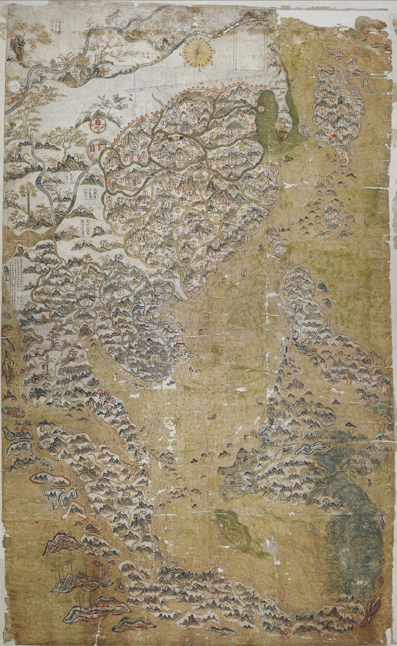
The object described in this record, MS. Selden supra 105, photographed after the 2011 conservation. Ink and watercolour on Chinese paper, c. 1608-1624, maker unknown. Bequeathed to the Bodleian Library by John Selden in 1659.
| Maker | Unknown Chinese (probably Fujianese) chartmaker, working in Southeast Asia |
|---|---|
| Date | c. 1607-1624 (window established by internal evidence; the Bodleian's own conservation project dates it to the 1620s, Robert Batchelor argues c. 1619, Timothy Brook argues c. 1608) |
| Medium | Black carbon ink, watercolour and mineral pigments on Chinese paper, multiple sheets joined |
| Dimensions | Approximately 158 x 96 cm (the Bodleian's own conservation project page rounds this to 1.6 x 1 m) |
| Where it is now | Bodleian Library, University of Oxfordlast confirmed |
| Inventory number | MS. Selden supra 105 |
| Attribution | UnknownThe map is unsigned and carries no title, maker's name or date. Full note |
| Object type | Map |
| Period | Late Ming dynasty, Chinese maritime Southeast Asia |
| Cases | Has a provenance gap · Rediscovered |
| Inscriptions | Chinese place names, route annotations and a legend in Chinese characters by the original hand; Latin marginal translations added in 1687 by the Bodleian's Thomas Hyde with the Chinese Jesuit convert Michael Shen Fuzong |
| Owners on record | 13 links10 documented, 1 disputed, 2 unknown |
| Sources | 15 cited |
About this record Last verified · 15 sources cited · Change log
On this page 9 sections
ContentsClose
A large hand-painted Chinese merchant chart of about 1608 to 1624, showing shipping routes with compass bearings radiating from a Fujian port across the South China Sea to Japan, the Philippines, Java, Sumatra and the Indian Ocean beyond. It is not the territorial, China-centred map its cataloguers assumed for three centuries; it is the earliest surviving record of a private Chinese maritime trading network that appears on no other map of the period, official or otherwise.
Bequeathed to the Bodleian by the lawyer John Selden in 1659, it was studied once in 1687, dismissed as inaccurate by Edmond Halley some time after, and then effectively forgotten in the stacks for roughly three centuries. Historian Robert Batchelor recognised its significance in January 2008; a major conservation campaign followed in 2011; scientific analysis of its pigments in 2016 proposed a origin far from where most scholars had assumed. Where exactly it was made, for whom, and when its compass rose and route grid were set down relative to the coastline beneath them remain open and actively disputed questions.
This record treats every one of those disputes as live, names who holds which position, and states plainly what has not been settled.
Provenance
Each link is graded. Documented: a cited source supports it. Disputed: the identification is argued but not established. Unknown: no owner for that span, and the gap is not smoothed into a narrative. The grades in the glossary.
- c. 1608-1624 -Unknown maker and, if Batchelor's hypothesis is followed, an unnamed merchant patron possibly connected to Li Dandisputed
Made by an unidentified Chinese, probably Fujianese, chartmaker working in the maritime trading world of Southeast Asia. Place of manufacture (Manila, Java/Banten, or Aceh) and exact date within the window are each argued differently by Batchelor, Brook and the 2016 Kogou pigment study, with no consensus reached.9845
- c. 1608-1650s - 1653Unknown intermediate holders, then an unnamed English commanderunknown
How the map left Chinese or Southeast Asian hands is not documented. John Selden's own 1653 will codicil states the map was 'taken both by an englishe commander', a word implying seizure, but does not name him. Timothy Brook's proposal that the captain John Saris obtained it in 1608 and brought it to England in 1609 is a scholarly inference, not a documented identification.12914
- by 1653 - 1654John Seldendocumented
The map, with an accompanying Chinese-made compass, is described in a codicil to Selden's will dated 11 June 1653. Selden, the jurist and author of Mare Clausum, died in 1654.129
- 1654 - 1659Selden's estate, in probatedocumented
The map passed to the Bodleian under the terms of Selden's will following his death in 1654; the library records its arrival in 1659.19
- 1659 - 1687Bodleian Librarydocumented
The map entered the Bodleian's collection in 1659. Its Chinese text remained untranslated and largely unread at Oxford for nearly three decades.19
- 1687 - 1687Bodleian Librarydocumented
Thomas Hyde, the Bodleian's librarian and an orientalist, worked with the visiting Chinese Jesuit convert Michael Shen Fuzong to add Latin marginal translations of the map's Chinese place names and legends.98
- early 18th century - 20th centuryBodleian Libraryunknown
Later secondary accounts describe the map on display in the Bodleian's Anatomy School by the early eighteenth century, and describe Edmond Halley dismissing its cartographic accuracy at some later point, a judgement credited with its subsequent neglect. Both claims are carried in this record only via a tertiary source (Wikipedia) and were not independently verified against a primary account for this record; they should be replaced with a primary citation before this provenance line is treated as settled.14
- 1919 - 2011Bodleian Librarydocumented
The map was remounted, apparently in 1919, with a thick paper border and cloth lining to permit wall-hanging display, causing severe cracking of the original paper support that worsened with each unrolling.1
- 2008 - 2008Bodleian Librarydocumented
Historian Robert Batchelor, working with the Bodleian's curator of Chinese collections David Helliwell, recognised the map's shipping-route network and its significance in January 2008. The map itself never left the Bodleian; what changed was its correct identification.910
- 2011 - 2011Bodleian Librarydocumented
Conservation led by Robert Minte and Marinita Stiglitz, with Keisuke Sugiyama (British Museum) and Mark Barnard (British Library), combined Western and Far Eastern paper-conservation techniques. The conserved map went on public display in the Bodleian's autumn 2011 Treasures exhibition (30 September - 23 December), with a one-day scholarly colloquium of about fifty specialists.110
- 2016 - 2016Bodleian Librarydocumented
A team led by Sotiria Kogou (Nottingham Trent University, with the Victoria and Albert Museum's science section) published pigment, binder and multispectral imaging analysis proposing Aceh, Sumatra as the map's place of origin.45
- 2019 - 2020Bodleian Librarydocumented
The map travelled outside Oxford for the first time in its documented history, shown jointly with the National Library and Asian Civilisations Museum, Singapore, alongside a parallel display at the Bodleian's Weston Library, both running into early 2020.9
- 2021 - presentBodleian Librarydocumented
The map remains at the Bodleian under shelfmark MS. Selden supra 105, accessible as a full zoomable image through Digital Bodleian and the dedicated project site seldenmap.bodleian.ox.ac.uk. Research continues, including Wesa Perttola's 2021 computational analysis of the map's routes against historical monsoon wind data. The map has never been sold; no export question has arisen, since it has not left institutional custody since 1659.6131
Technical evidence
| Attribution note | The map is unsigned and carries no title, maker's name or date. Every attribution offered since its 2008 rediscovery is a scholarly inference from internal evidence: place-name density, pigment chemistry, magnetic declination and the port network implied by the routes. No document naming a maker, patron or workshop has been found. Robert Batchelor's proposal that it was made for the merchant-pirate Li Dan is the most specific patron theory in print, but it is argued, not documented, and other scholars place the map's origin in a different port entirely. |
|---|---|
| Support | Chinese paper, several sheets joined to form the full sheet, prepared and painted in a landscape-painting technique.91 |
| Dimensions | Approximately 158 x 96 cm; the Bodleian's own conservation project page rounds this to 1.6 x 1 m.18 |
| Binding medium | Gum arabic, identified by non-invasive analysis in 2016. This is unusual for Chinese painting of the period, which conventionally used animal glue.45 |
| Green pigment | A mixture of indigo and orpiment together with a basic copper chloride consistent with atacamite, a combination the 2016 study associates with Persian and South and West Asian painting practice rather than the standard Chinese palette.45 |
| Compass rose and scale bar | A European-style compass rose and a graduated scale bar, features with no known precedent on any earlier Chinese map; the compass rose is tilted to magnetic rather than true declination.894 |
| Distance unit | Routes are scaled in geng (watches), a Chinese navigational time unit of about 2.4 hours, ten to a day, derived from the burning time of a length of incense.98 |
| Construction sequence | Surviving drafting marks show the bordered box was drawn first, then the scale bar at an angle to it, then the compass rose from a line perpendicular to the scale bar. Separately, the shipping routes were laid down before the coastline and decorative landscape elements were painted in over them.345 |
| Underdraft | A complete duplicate draft of the main Nagasaki-to-Pahang route, with hash marks for ruling distances, was found painted on the reverse of the sheet when the backing was removed in 2011.114 |
| 1919 remounting | A thick paper border and cloth lining applied to permit wall-hanging display, which caused severe cracking of the original paper support; removed during the 2011 conservation and replaced with materials suited to the object rather than to display.1 |
| 1687 annotations | Latin marginal translations of Chinese place names and legends, added by the Bodleian librarian Thomas Hyde with the Chinese Jesuit convert Michael Shen Fuzong. This is a distinct, dateable layer added after the map reached Oxford, not part of the original object.98 |
Images
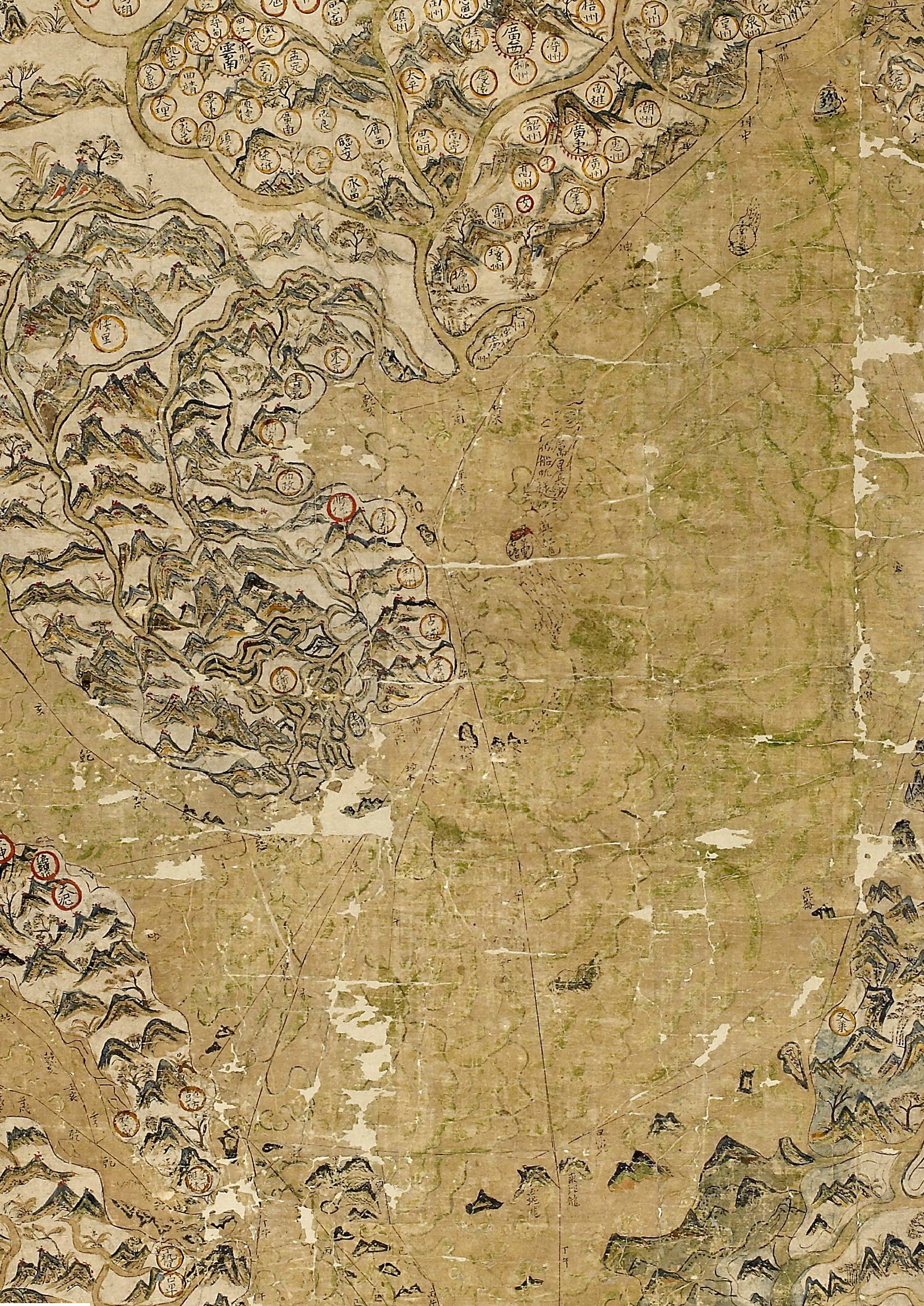
The record in full
Chapter 1A merchant's chart, not an empire's map
The Selden Map is a large sheet of Chinese paper, made up of smaller sheets joined together, painted in black carbon ink and watercolour and measuring approximately 158 by 96 centimetres.
The Selden Map is a large sheet of Chinese paper, made up of smaller sheets joined together, painted in black carbon ink and watercolour and measuring approximately 158 by 96 centimetres. For roughly three hundred and fifty years it sat in the Bodleian Library catalogued, in effect, as an oddity: an unusually large, unusually decorative Chinese map of no settled purpose. What Robert Batchelor recognised in January 2008, examining it shortly before returning to the United States, was that the faint lines he could see radiating out from a point on the Fujian coast were shipping routes, plotted with compass bearings, and that nothing resembling them survived on any other Chinese map of the period.
The distinction matters because it changes what kind of object this is. Official Ming cartography of the period is centred on China itself, with the rest of the world reduced to a thin decorative margin of tributary and barbarian lands. The Selden Map inverts that convention. China occupies less than half of the sheet. The map's true centre is the South China Sea, and its subject is not territory but movement: a network of named ports from Japan to Sumatra and the Indian Ocean, connected by a mesh of routes that a merchant, not a magistrate, would need to read.
Chapter 2What the routes actually show
The shipping lines radiate outward from a point near the neighbouring Fujian ports of Quanzhou and Zhangzhou.
The shipping lines radiate outward from a point near the neighbouring Fujian ports of Quanzhou and Zhangzhou. From there the primary routes run northeast to Nagasaki and southwest through Hoi An, Champa and Pahang, with further branches reaching Manila, Java, Aceh at the northern tip of Sumatra, and on toward the Persian Gulf and Red Sea. Distances along the routes are given not in linear measure but in geng, or watches: a Chinese navigational unit of roughly 2.4 hours, ten to a day, derived from the time it took a length of incense to burn. That is a mariner's unit, not a cartographer's, and it is one of the strongest pieces of internal evidence that the routes were compiled from real rutters, sailing directions accumulated voyage by voyage, rather than drawn from an existing map.
The port network the routes describe is not the network of the official tribute system. It is a private, commercial network, evidently built up by people who actually sailed it. That is the single fact that makes the map historically important: it is direct physical evidence that an unofficial Chinese maritime trading world existed at this scale in the early seventeenth century, at a moment when European accounts and most surviving Chinese sources describe a state actively restricting private overseas trade.
Chapter 3How it was made: materials and a working method now partly visible
The support is Chinese paper, several sheets joined to make the full sheet, prepared and painted using landscape-painting conventions, ink and mineral colour.
The support is Chinese paper, several sheets joined to make the full sheet, prepared and painted using landscape-painting conventions, ink and mineral colour. Scientific analysis carried out in 2016 by a team led by Sotiria Kogou at Nottingham Trent University, working with the Victoria and Albert Museum's science section, used non-invasive multispectral imaging alongside pigment and binder analysis and found some choices at odds with ordinary Chinese painting practice of the period. The binding medium identified was gum arabic rather than the animal glue conventional in Chinese painting; the green passages combine indigo with orpiment, a yellow arsenic mineral, together with a basic copper chloride consistent with atacamite, a pairing the team associated more closely with the Persian and South and West Asian painting tradition than with the Chinese one.
Two construction details recovered by later study bear directly on how the map was assembled rather than only what it depicts. Stephen Davies, analysing the surviving construction lines for the 2013 Imago Mundi special issue on the map, traced the drafting sequence of its framing elements: the bordered box was laid out first, then the scale bar at an angle to it, and only then the compass rose, built from a line drawn perpendicular to the scale bar. Separately, the 2016 Kogou team found that the shipping routes themselves were laid down before the coastline, cities and decorative landscape elements were painted in over them - the routes came first, the geography was fitted around them, not the reverse. Conservation work in 2011 confirmed the same point physically: when the nineteenth- and twentieth-century backing was removed, a full duplicate draft of the main Nagasaki-to-Pahang route, together with hash marks used to rule off distances, was found on the reverse of the sheet, matching the routes on the front.
Taken together, this is a map that was planned from its trade routes outward, revised as it was built, and finished with a European-derived compass rose and scale bar, drafted onto the sheet in a fixed internal order (frame box, then scale bar, then compass rose, per Davies) after the shipping routes had already been laid down over the coastline (per Kogou). Whether that sequence reflects one hand working in stages, or a second hand finishing what an earlier draftsman began, is not established by either study; see Open Questions.
Chapter 4The compass rose, the scale bar, and what they signal
Neither a compass rose nor a graduated scale bar of this kind is known from any earlier Chinese map.
Neither a compass rose nor a graduated scale bar of this kind is known from any earlier Chinese map. Their presence on the Selden Map is treated across the literature - by Batchelor, by Davies, and in the general secondary accounts that followed the 2011 conservation - as evidence that its maker had direct or indirect knowledge of European navigational chartmaking, most likely through contact with Portuguese, Spanish or Dutch shipping and the ports those powers used in Southeast Asia. That the compass rose is tilted rather than aligned to true north is itself informative: the tilt corresponds to magnetic, not true, declination, and its precise angle became one of the key pieces of evidence the 2016 pigment-and-declination study used to argue for a specific port of origin (see below).
What is not established, despite being an active line of inquiry, is whether the compass rose and the route grid belong to the same drafting campaign as the coastline and place names, or were added afterward, possibly by a different hand, once the base map existed. The construction-sequence evidence recovered by Davies shows a clear order of drafting marks for the box, scale bar and compass rose; it does not by itself establish whether that sequence took place within a single continuous campaign or after an interval, still less whether it was the same artist's hand throughout. No source consulted for this record states outright that a second hand added the compass rose or the route grid; the record's language matches the evidence, not the stronger claim.
Chapter 5Who it was made for: the disputed patron
No patron is named on the map, and the question of who commissioned it, and why, is unresolved.
No patron is named on the map, and the question of who commissioned it, and why, is unresolved. The most specific proposal in print is Robert Batchelor's: that the map was made for, or in the milieu of, the merchant-pirate Li Dan, patron of Zheng Zhilong (father of the Ming loyalist commander Koxinga) and a dominant figure in the Chinese trading diaspora of the 1610s and 1620s. Batchelor points to Li Dan's documented career - based first in Manila, later at Hirado in Japan after imprisonment by the Spanish - and to a cluster of bright red chrysanthemum motifs on the map near Hirado, a decorative detail unique on the sheet, as a possible marker of the patron's own base of operations. This is an argued case resting on circumstantial convergence, not a documented commission; Batchelor presents it as a hypothesis, and other scholars have not adopted it.
The more general and less contested reading, offered by multiple secondary accounts including the historian Hannah Theaker's, is that the map was made for an unnamed wealthy merchant, to be displayed - as the same accounts put it - in a reception hall or entrance, as a visible statement of the range of the owner's trading connections rather than as a working navigational instrument. Its scale, its decorative landscape painting, and the fact that its routes, while functionally derived from real sailing data, are laid out with an evident concern for visual balance across the sheet, all support a display object commissioned to be seen by visitors as much as read by a navigator.
Chapter 6Where it was made: three ports, no consensus
Three places have each been proposed in the scholarly literature as the map's place of origin, and none commands a consensus.Timothy Brook, in his 2013 book on the map, argues for a Java origin, on...
Three places have each been proposed in the scholarly literature as the map's place of origin, and none commands a consensus.
Timothy Brook, in his 2013 book on the map, argues for a Java origin, on the grounds that the southern half of the map, covering the archipelago, shows superior and more current geographic knowledge than the northern half. Batchelor, drawing on the port density around Luzon, Japan and Vietnam and on the Li Dan hypothesis above, argues instead for Manila or a source close to it. The 2016 scientific study led by Kogou proposed a third location entirely: Aceh, at the northwestern tip of Sumatra, based on a combination of pigment and binder chemistry unusual for the Chinese tradition but consistent with the Persian and South and West Asian palette that would have been available in a port with a substantial Islamic trading presence, together with the finding that Aceh is the only port marked on the map with a magnetic declination in the early seventeenth century matching the tilt of the compass rose. Aceh is also one of only six ports marked on the map with a red circle, a detail the same study reads as a possible sign of the map owner's principal base.
Each theory rests on a different category of evidence - documentary and geographic argument from Brook, patron biography and port density from Batchelor, hard material science from Kogou's team - and none of the three has been retracted or has displaced the others. This record treats the question of where the map was made as genuinely open, and lists it as such under Open Questions rather than adopting any one position.
Chapter 7Dating the map: 1608 or 1619
Internal evidence narrows the map's creation to a window between 1607 and 1624, but two scholars have argued for materially different dates within it.
Internal evidence narrows the map's creation to a window between 1607 and 1624, but two scholars have argued for materially different dates within it. Timothy Brook contends that the English East India Company captain John Saris obtained the map in 1608, while trading in Southeast Asia, and brought it to England in October 1609, which would place the map's creation at or before 1608. Robert Batchelor argues for a later date, around 1619, on the basis of the detail with which Taiwan is depicted, which he reads as reflecting geographic knowledge that only accumulated through the 1610s. The two datings differ by roughly a decade and rest on different kinds of evidence: Brook's on a specific proposed transmission event, Batchelor's on internal cartographic content. The Bodleian's own conservation project page, for its part, dates the map to the 1620s without adopting either scholar's argument directly. No single date is treated as settled in the literature consulted for this record.
Chapter 8How it reached England: an East India Company connection, but not a settled chain
John Selden's own words are the earliest documented reference to the map's presence in England.
John Selden's own words are the earliest documented reference to the map's presence in England. In a codicil to his will dated 11 June 1653, Selden describes bequeathing 'a Mapp of China made there fairly and done in colloure together with a Sea Compasse of their making and Devisione taken both by an englishe commander.' That sentence is the primary source for two facts and one open question: the map was accompanied, at least at one point, by a Chinese-made compass; and it was 'taken' - a word implying capture or seizure rather than purchase - by an English commander, whose identity Selden does not give. Brook's Saris hypothesis is the most specific candidate offered for that unnamed commander, tied to Saris's 1608 to 1609 voyage as chief factor of the East India Company's mission and his return passage to England, but Selden's codicil itself does not name Saris, and the identification is Brook's inference, not documented fact.
What is solidly established is the East India Company context generally: the map passed through hands connected to the Company's trading and shipping network in maritime Southeast Asia at some point between its creation and its appearance in Selden's possession by 1653. The precise mechanism of capture or acquisition, the ship involved, and the date it left Asian waters are not documented in any source consulted for this record.
Chapter 9Selden, the Bodleian, and three centuries of obscurity
John Selden, the jurist and maritime-law scholar best known for Mare Clausum, his rebuttal to Grotius's Mare Liberum, died in 1654.
John Selden, the jurist and maritime-law scholar best known for Mare Clausum, his rebuttal to Grotius's Mare Liberum, died in 1654. His library and his collection, including the map, passed to the Bodleian under the terms of his will, reaching the library in 1659. For nearly three decades afterward the map's Chinese text was simply illegible to anyone at Oxford. That changed in 1687, when Michael Shen Fuzong, a Chinese convert to Christianity travelling in Europe, visited Oxford and worked with the Bodleian's librarian and orientalist Thomas Hyde to add Latin marginal translations of the map's place names and legends - the only layer of annotation added to the map after it left its original maker's hands, and itself now a distinct historical layer worth reading as evidence of late-seventeenth-century European curiosity about China rather than as part of the original object.
After 1687 the map's documented trail thins. Later secondary accounts describe it on display as a curiosity in the Bodleian's Anatomy School by the early eighteenth century, and describe the astronomer Edmond Halley examining it and dismissing its cartographic accuracy at some point thereafter, a judgement credited with helping consign it to obscurity. Neither of these two claims was independently verified against a primary source for this record; both derive from the Wikipedia article on the map, which is flagged in Sources for replacement with a citation to Batchelor's or Brook's own account of the map's institutional history. What is certain is the outcome: by the twentieth century the map was mounted flat as a wall hanging, rather than stored and handled as a manuscript, a decision that would go on to cause serious physical damage, and it remained outside serious scholarly attention until 2008.
Chapter 10Rediscovery, January 2008
Robert Batchelor, an American historian, examined the map at the Bodleian in January 2008, shortly before leaving Oxford to return to the United States, working with David Helliwell, the library's...
Robert Batchelor, an American historian, examined the map at the Bodleian in January 2008, shortly before leaving Oxford to return to the United States, working with David Helliwell, the library's curator of Chinese collections. What Batchelor identified - the shipping-route network, the compass bearings, and the map's status as a document of private maritime trade rather than official territorial cartography - had gone unrecognised for the length of the map's time at Oxford. The rediscovery set off the research programme that produced Batchelor's own 2013 Imago Mundi article and 2014 book, Brook's 2013 book, Davies's construction study, and eventually the 2011 conservation project and the 2016 scientific analysis, none of which could have proceeded without the map first being correctly read for what it was.
Chapter 11Condition before conservation, and the damage a well-meaning remounting caused
By the time of its rediscovery the map was in poor physical condition.
By the time of its rediscovery the map was in poor physical condition. Bodleian conservation records describe it as having been remounted, apparently in 1919, with a thick paper border and a cloth lining intended to let it be displayed and handled as a wall hanging. That intervention, whatever its intent, caused severe cracking of the original Chinese paper support: fragments of the painted surface were falling away with every unrolling of the map by the time conservation work began in 2011. The 1919 remounting is a clear example of a well-intentioned repair actively harming the object it was meant to protect, and it is the single largest physical threat the map faced in its documented history.
Chapter 12The 2011 conservation project
Conservation ran across 2011, ahead of the map's public unveiling that September, led by the Bodleian's Robert Minte and Marinita Stiglitz, working with Keisuke Sugiyama of the British Museum and...
Conservation ran across 2011, ahead of the map's public unveiling that September, led by the Bodleian's Robert Minte and Marinita Stiglitz, working with Keisuke Sugiyama of the British Museum and Mark Barnard of the British Library. The project deliberately combined Western paper conservation with Far Eastern painting conservation techniques, on the reasoning that a Chinese paper support required treatment methods that a Western-trained conservator working alone would not have applied. Practically, this meant gradual humidification of the paper from both sides using traditional dahlia-style sprayers, which drew out historic discolouration and allowed the distorted sheet to be flattened; removal of the twentieth-century textile lining and thick paper border; and the application of new infills and a new lining suited to the object's structure rather than to wall-hanging display.
Removing the old backing exposed what conservation had not been designed to find: a complete draft of the main Nagasaki-to-Pahang shipping route on the reverse of the sheet, along with hash marks used to rule off distances, confirming that the routes were laid out methodically and checked, not painted freehand. This is the physical evidence behind the construction-sequence conclusions reached separately by Davies and by the 2016 Kogou team. Only the earliest paper border, carrying the 1687 Latin annotations, was judged original enough to retain; every later intervention was removed.
Chapter 13Unveiling, scholarship, and what conservation made possible
The conserved map went on public display for the first time in the Bodleian's autumn 2011 Treasures exhibition, running from 30 September to 23 December that year, alongside a one-day colloquium that...
The conserved map went on public display for the first time in the Bodleian's autumn 2011 Treasures exhibition, running from 30 September to 23 December that year, alongside a one-day colloquium that brought together around fifty cartographic and East Asian specialists to examine it directly. Contemporary reporting placed its insurance valuation at roughly four million pounds at that point, a figure reflecting institutional insurance practice rather than any market transaction; the map has never been sold and no export question has ever arisen, since it has remained in the Bodleian's custody without interruption since 1659.
The conservation project is also what made the 2016 scientific study possible: without the backing removed and the paper stabilised, the multispectral imaging and pigment sampling that underpin the Aceh hypothesis could not have been carried out. The map subsequently travelled outside Oxford for the first time in its documented history, appearing in a joint loan exhibition with the National Library and the Asian Civilisations Museum in Singapore that ran into early 2020, alongside a parallel display at the Bodleian's Weston Library.
Chapter 14What is happening to it now
The map remains in the Bodleian's permanent collection under its historic shelfmark, MS.
The map remains in the Bodleian's permanent collection under its historic shelfmark, MS. Selden supra 105, viewable in full through the Digital Bodleian platform and through a dedicated project site, seldenmap.bodleian.ox.ac.uk, both offering a zoomable IIIF-compliant image. It is not, so far as this research established, on continuous physical public display; access for study is through the digital surrogate and, for scholars, through the Bodleian's manuscript reading rooms by appointment.
Research on the map continues. In 2021 Wesa Perttola, of the University of Helsinki, published a computational study modelling the sailing durations implied by the map's routes against reconstructed historical monsoon wind data, using sequential least-cost path analysis - a modern maritime-archaeology method applied directly to the map's own encoded voyage data, testing whether its routes are navigationally plausible under real seasonal wind conditions rather than only visually coherent. The map has also acquired a documented afterlife in contemporary politics: it is cited, including by commentators critical of the practice, in discussions of China's historical claims in the South China Sea, precisely because it is genuine seventeenth-century evidence of Chinese maritime activity in those waters - evidence that nonetheless documents private merchant trade, not territorial sovereignty, and that an international tribunal at The Hague explicitly declined to treat as establishing modern historical rights when it rejected China's nine-dash-line claims in 2016. Citing the Selden Map in that debate uses it for a claim - sovereignty - that the map itself, a merchant's chart, was never made to support.
The artist
Unknown Chinese chartmaker, probably Fujianese, working outside China in the maritime trading world of the South China Sea
The map names no maker, and none has been identified. What can be said rests entirely on internal evidence: the cartographer's command of a specific, mariner-derived unit of measure, a working method reconstructed from the drafting marks and the underdraft found beneath the surface paint, and a set of material choices in the pigments and binder that several scholars read as evidence of contact with, or residence in, a trading community outside China proper. This dossier reports what the evidence supports about the maker's practice and milieu, not a biography, because no biography of this person exists or is likely to be recoverable.
Related works
| Work | Relation | Where it is |
|---|---|---|
| Shunfeng Xiangsong (Fair Winds for Escort) Unknown compiler | A separate Chinese maritime route book, not a map, held in the Bodleian's Laud collection (bequeathed by Archbishop William Laud). Comparandum for the same body of navigational knowledge in a different form. This is a distinct manuscript and a distinct object; it is not a version of the Selden Map and should not be confused with it. | Bodleian Library, Oxford |
| Wubei Zhi (Treatise on Military Preparedness), voyage charts of Zheng He Compiled by Mao Yuanyi, c. 1628 | Contains the best-known surviving Ming-era Chinese charts of Zheng He's early fifteenth-century voyages; a comparandum for official Chinese maritime cartography, against which the Selden Map's private, merchant character stands out. A different compilation from a different tradition (official naval record rather than merchant chart); not a version of this object. | Multiple surviving editions and copies; not held with the Selden Map |
| Dongxi Yangkao (Study of the Eastern and Western Oceans) Zhang Xie, 1617 | A printed contemporary treatise on the same shipping world the Selden Map depicts, giving textual sailing directions rather than a drawn chart; useful as an independent check on the plausibility of the map's routes and dates. A text, not a map, and a separate object from a separate author; not to be confused with the Selden Map itself. | Surviving in printed editions in multiple libraries |
| The Cantino planisphere Unknown Portuguese chartmaker, 1502 | Not from the same tradition and over a century earlier; included only as the likely source, at several removes, of the European compass-rose and graduated-scale convention that the Selden Map's maker adopted. A wholly separate object from a separate cartographic culture and century; the connection is conventional and indirect, not a claim of shared authorship, ownership or transmission. | Biblioteca Estense Universitaria, Modena |
Open questions
- Where exactly was the map made. Three ports have each been proposed on different kinds of evidence - Manila (Batchelor), Java or Banten (Brook), Aceh in Sumatra (Kogou et al., 2016, on pigment chemistry and magnetic declination) - and none has displaced the others.
- When exactly was it made within the 1607-1624 window. Brook argues c. 1608, tied to a proposed 1608-1609 transmission by John Saris; Batchelor argues c. 1619, from the density of Taiwan detail. The two datings differ by roughly a decade.
- Who commissioned it, and why. Batchelor's proposal of the merchant-pirate Li Dan as patron rests on circumstantial convergence (a unique motif near his documented base at Hirado) and has not been adopted by other scholars; no commission, contract or named patron is documented.
- Whether the compass rose and shipping-route grid belong to the same drafting campaign, by the same hand, as the coastline and place names beneath them, or were added afterward, possibly by a different hand. Construction-sequence evidence (Davies) establishes an order of drafting marks but not whether that reflects a continuous campaign or a later, separate intervention; no source consulted for this record confirms a second-hand theory outright, despite it being discussed as a live possibility.
- The identity of the 'englishe commander' named, but not identified, in Selden's own 1653 will codicil, and the precise circumstances - a word Selden himself renders as 'taken' - under which the map and its accompanying compass left Chinese or Southeast Asian hands. Brook's proposed identification of John Saris is an inference, not a documented fact.
- What happened to the map between the 1687 Hyde-Shen Fuzong annotation and its twentieth-century remounting. Its display in the Anatomy School and Edmond Halley's reported dismissal of its accuracy are carried only by a tertiary source (Wikipedia) in the research for this record and were not independently verified against a primary Bodleian or biographical source.
- Whether the rutters (sailing directions) that evidently underlie the map's route data survive independently anywhere, in Chinese, Fujianese-diaspora or European archives, or whether the Selden Map is the sole surviving trace of that specific body of navigational knowledge.
Questions about this object
What is The Selden Map of China?
The Selden Map of China is a map, dated c. 1607-1624 (window established by internal evidence; the Bodleian's own conservation project dates it to the 1620s, Robert Batchelor argues c. 1619, Timothy Brook argues c. 1608). Medium: Black carbon ink, watercolour and mineral pigments on Chinese paper, multiple sheets joined.
Who made The Selden Map of China, and is the attribution settled?
The attribution to Unknown Chinese (probably Fujianese) chartmaker, working in Southeast Asia is recorded here as unknown. The map is unsigned and carries no title, maker's name or date. Every attribution offered since its 2008 rediscovery is a scholarly inference from internal evidence: place-name density, pigment chemistry, magnetic declination and the port network implied by the routes. No document naming a maker, patron or workshop has been found. Robert Batchelor's proposal that it was made for the merchant-pirate Li Dan is the most specific patron theory in print, but it is argued, not documented, and other scholars place the map's origin in a different port entirely.
Where is The Selden Map of China now?
Bodleian Library, University of Oxford. Inventory number MS. Selden supra 105. Last confirmed 2 August 2026. In continuous institutional custody since John Selden's bequest reached the library in 1659; never sold, exported or deaccessioned.
What is still unknown about The Selden Map of China?
Where exactly was the map made. Three ports have each been proposed on different kinds of evidence - Manila (Batchelor), Java or Banten (Brook), Aceh in Sumatra (Kogou et al., 2016, on pigment chemistry and magnetic declination) - and none has displaced the others.
Sources
- 1Bodleian Libraries, 'The Selden Map of China conservation project'. bodleian.ox.ac.uk/about/...
- 2Robert K. Batchelor, 'The Selden Map Rediscovered: A Chinese Map of East Asian Shipping Routes, c.1619', Imago Mundi 65:1 (2013). Accessed via the author's Digital Commons deposit page. digitalcommons.georgiasouthern.edu/history-facpubs/...
- 3Stephen Davies, 'The Construction of the Selden Map: Some Conjectures', Imago Mundi 65:1 (2013). tandfonline.com/doi/...
- 4Sotiria Kogou, Sara Neate, Chris Coveney, Adam Miles, David Boocock, Lucia Burgio, C. S. Cheung and Haida Liang, 'The origins of the Selden map of China: scientific analysis of the painting materials and techniques using a holistic approach', Heritage Science 4:28 (2016). nature.com/articles/...
- 5Phys.org, 'Scientists unlock secrets of oldest surviving global trade map' (2017), reporting the Kogou et al. 2016 study. phys.org/news/...
- 6The Selden Map of China, dedicated Bodleian project site. seldenmap.bodleian.ox.ac.uk
- 7Digital Bodleian, object record for MS. Selden supra 105. digital.bodleian.ox.ac.uk/objects/...
- 8World Archaeology, 'Object lesson: Selden Map of China'. world-archaeology.com/world/...
- 9New World Cartographic, 'The Selden Map: A Ming Dynasty Maritime Marvel'. nwcartographic.com/blogs/...
- 10South China Morning Post, 'Selden seen', on the 2011 unveiling and conservation. scmp.com/article/...
- 11Hannah Theaker, 'The Selden Map of China', China Channel (Los Angeles Review of Books), 11 February 2021. chinachannel.larbpublishingworkshop.org/2021/...
- 12ChinaSage, 'John Selden's map of 1608'. chinasage.info/selden-map.htm
- 13Wesa Perttola, 'Digital Navigator on the Seas of the Selden Map of China: Sequential Least-Cost Path Analysis Using Dynamic Wind Data', Journal of Archaeological Method and Theory (2021). link.springer.com/article/...
- 14Wikipedia, 'Selden Map', consolidating institutional history including the Anatomy School display and Halley's dismissal of the map's accuracy. en.wikipedia.org/wiki/...
- 15Wikimedia Commons, File:Selden map.jpg, image record and licensing metadata. commons.wikimedia.org/wiki/...

Last verified · Published
Change log
15 August 2026 - Record created at the house standard: researched narrative, technical evidence, maker dossier, graded provenance chain, prices with hammer and premium separated, related works, open questions and sources.